
Facts
- Elevation: 2,450 m (8,038 ft)
- Prominence: 980 m
- Peak category:
 Spesial
 - Province:
 Jawa Barat (West Java)
 - Coordinates: -7.1624, 107.3992
- Rating:


 (9 votes) Add your rating
 Loading...
 - Other names: Sepuh, Malaya (ancient name)
Photos


Bagging It!
Gunung Patuha is just over 40km from Bandung city, near Sugih village in the district of Pasir Jambu. It is the highest peak in the large highland area between the Gede-Pangrango massif and the mountains of Garut. The word ‘patuha’ apparently comes from the words “Pak Tua” (old man), perhaps referring to it being the highest peak, looking out over a vast region of forested peaks south of Bandung. Just as we have the Old Man of Coniston in England’s Lake District, so West Java has the Old Man of Parahyangan.
It is known locally as Gunung Sepuh and its ancient name was Gunung Malaya. The mountain has considerable historical significance as the pilgrim in the Sundanese Hindu text Bujangga Manik written over 500 years ago ended his spiritual journey here, perhaps even in the old crater now known as Kawah Saat (saat = ‘dry’ in Sundanese).
It’s actually a twin volcano – with two summit craters of completely different character. The forest-covered north crater, Kawah Saat, is the highest of the two and has been dormant for many centuries. The south crater, known as Kawah Putih (white crater), is a leading local tourist attraction. The latter is incredibly popular with visitors at weekends and was written about by Dr. Franz Wihelm Junghuhn (1809-1864), a Dutch botanist from Germany.
He found that the high density of sulphur was making birds reluctant to fly over the crater. Locals still regard the area as haunted and the atmosphere is definitely one of eerie calm. During the 20th century, the Dutch built a sulphur mine which was later controlled by the Japanese military. Sulphur mine tunnels and the remnants of old buildings still exist to this day. There are also several ancient graves in the area and places where locals pray and make offerings.
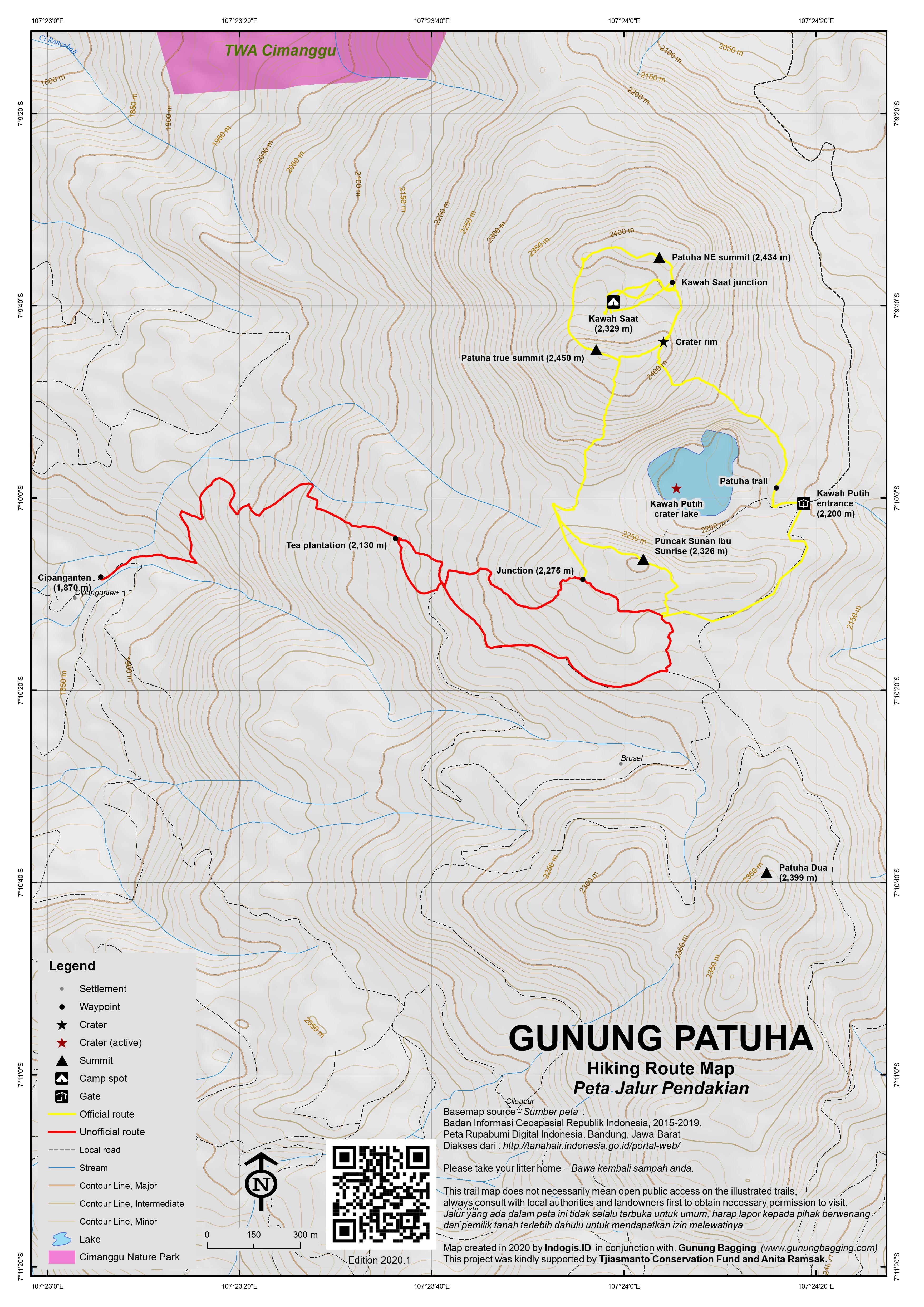
There are two main approaches to the mountain – one via Kawah Putih and one via the village of Cipanganten in the nearby tea plantations. Kawah Putih is by far the most popular, and is also the official route.
Route via Kawah Putih
The Kawah Putih car park is at an elevation of 2,200m so it’s a very easy climb to the top. Assuming you simply want to reach the highest peak and visit the edge of Kawah Putih lake, you can manage it in just two hours!
From Bandung, there are plenty of angkots serving the main road south-west to Soreang and Ciwidey and it is an easy day-trip from Bandung. However, you will have to change vehicle at least once so it is much better to avoid the waiting around and hire a taxi/private car. It takes approximately 90 minutes from the centre of Bandung to the top of the road at Kawah Putih but try to avoid weekends if you can due to the amount of traffic. Beyond Ciwidey, the road is lined with strawberry fields, plants for sale and related produce. From this point, Kawah Putih is well signposted and it is very hard to miss the entrance gates.
Since 1987 Kawah Putih has been an official tourist site and has an information centre and cafe. Prices have been rising in recent years and in 2020 entrance tickets are Rp75,000 for foreigners and Rp25,000 for locals. The main entrance on the main road is open from around 7am until 5pm (but possibly extended at weekends) and unless you want to pay Rp150,000 to drive your car up to the lake you need to take a minibus from the main road. Beyond the first entrance gates, the road climbs up over 5km through delightful eucalyptus plantation to the crater car park. There are several places worth stopping at briefly to admire the view of other forested peaks in the distance.
When you reach the top of the road and the proper Kawah Putih entrance, there is a large area for vehicles and small warungs (shops), and some excellent places for having a picnic. Kawah Putih itself is very impressive – a misty turquoise crater lake surrounded by white rocks and sand. There is a smell of sulphur but it is not overpowering. To reach the summit of Gunung Patuha, leave the car park at the stone tree trunk and continue up through the forest on a well-defined path to the right of Kawah Putih. The trail is very clear although not many Kawah Putih visitors hike this way.
After less than 30 minutes of ascent through the forest the edge of the old forested crater (‘Kawah Saat’) is reached. There is a flat area (2,430m) occasionally used for camping by locals who also make offerings here and hope for increased fertility. You may see eggs and coconuts left behind. This practice is very ancient, pre-dating Islam’s arrival in West Java. According to local people, this area was used in the past as a meeting place of the ancestors of South Bandung and it is certainly a great place for quiet contemplation.
From this point you can look down over the edge to the forested, dormant northern crater floor (which has an elevation of 2,284m according to the Bakosurtanal map but GPS readings suggest a bit higher at around 2,329m). Apparently there were eruptions here several hundred years ago. From the camping spot, follow the less well-defined path leading left (west / clockwise) through the forest along the edge of the crater.
The trail ascends and descends and ascends again before you reach another flat, open area suitable for camping. There is a small collection of rocks which could well be a grave of some sort. Beyond this is another knoll, on the south-western rim of Kawah Saat which is the highest part of the mountain (approximately 2,450m – GPS readings gave 2,452m/2,453m) and in 2020 there are three signs nailed to a tree. If you peer over the near-vertical side of Kawah Saat, you will see a relatively recent landslide from here right down to the crater floor.
It is less than an hour back down the same way to the car park, although it is actually possible to do a full circuit of Kawah Saat crater rim. There is also a great viewpoint over Kawah Putih from the south which is known as Puncak Sunan Ibu Sunrise (see below for information on both).
Route via Cipanganten, including descending into Kawah Saat
With the growing popularity (indeed, over-popularity on weekends) of Kawah Putih, hikers ought to know it is possible to hike Gunung Patuha from a small village called Cipanganten to the south-west of the mountain, avoiding the crowds and excessive charges of Kawah Putih. This leads up from near the Rancabali tea plantation and Cipanganten village itself is at an elevation of around 1,870m. Note that if you want to reach Cipanganten you will need a vehicle with high clearance as the plantation track is very bumpy. The alternative is to walk in from the main road, which would require an estimated 45 minutes extra.
Permission is required from the villagers, and from the guard at the geothermal plant, but this is usually no problem so long as you are happy to pay a little for parking your vehicle.
From Cipanganten, the plantation tracks lead up to more extensive tea plantations. Be sure to use a GPS if you hike up without a guide from the village, as there are several tracks, and numerous short-cuts through the plantation.
A couple of kilometres to the south of Gunung Patuha is a double-topped peak which is the second highest peak in the range and has plantation tracks more or less encircling it near Cileueur. This ‘twin peak’ is visible from the higher reaches of the tea plantation, as you reach the edge of the forest.
This mountain is un-named on the Bakosurtanal map but it gives an elevation figure of 2,399 metres, and local hiking enthusiasts call it Patuha Dua (Patuha Number Two). You could also call it Patuha Selatan (South Patuha). If you look carefully, you will see a large cluster of rocks on the north-western side of Patuha Dua. This is apparently an ancient crater but it appears not to be active now.
At the north-eastern edge of the tea plantation, near an artificial lake (2,252m), you will meet a wide track which comes up from Kawah Putih tourist area. There is a small entrance to some steps (2,253m) that lead up to the rim (2,286m) and then Puncak Sunan Ibu Sunrise (2,326m). This is indeed a wonderful place to watch the sunrise, or indeed simply take panoramic photos over Kawah Putih, and it can be accessed via the usual Kawah Putih route or via the tea plantations as described here.
At the top of the steps is a knoll with a roped-off area for locals to pray and make offerings. The panorama is incredible – take extra care here are the drop down to Kawah Putih is near-vertical. In good weather you can see Malabar, Papandayan and Cikuray in the medium-distance to the east and south-east, and Gunung Ciremai in the far-distance to the north-east near Cirebon.
To the east of is a vast area of rarely-explored forested ridges, including Gunung Urug (2,205m), Gunung Puncaklawang (2,187m), Gunung Dewata (1,840m), Gunung Waringin (2,035m), Gunung Karangtengah (2,157m) and countless more un-named peaks. This stretches all the way to Gunung Tilu near Pangalengan and is in complete contrast to the overly-popular Kawah Putih.
To the north is Gunung Patuha, and to reach the summit from Puncak Sunan Ibu requires reasonably good navigation skills. As you may see, in 2019 there was an extensive forest fire here, and this terrain is not often hiked except by ultra-keen local hiking communities. It is actually possible to miss out Puncak Sunan Ibu Sunrise and trek via the tea plantation directly to the col between Puncak Sunan Ibu Sunrise and Patuha, but this path is best used on your descent, so that you can enjoy the views on the way up.
From Puncak Sunan Ibu Sunrise, simply follow the edge of the rim as it drops down to the col (2,235m). In 2020, there are some hectometer marker posts (red and white) and occasional orange ribbon tied to branches. Be sure to take a right near the col, as a left turn at the junction near the col will lead you down instead of up.
The higher slopes of Gunung Patuha are a little overgrown, with a few places requiring you to crawl or at the very least take off your backpack for a moment. Once on the crater rim (2,434m), be sure to make a mental note of this important point assuming you plan to return the same way rather than descend to the tourist site of Kawah Putih (which may cause confusion if you haven’t bought an entry ticket there).
You can make a full circuit of Kawah Saat, either clockwise or anti-clockwise. If you simply want to reach the highest point, head clockwise (left) for just 5 minutes or so, to the point with 3 signs nailed to a tree near a landslide area. If you want to do the full circuit, and have the option of actually descending into Kawah Saat, anti-clockwise is recommended, saving the highest peak until last.
From the vague trail junction on the Kawah Saat crater rim, take a right and follow the trail via the third-highest peak (2,444m on GPS), followed by the Kawah Putih carpark trail junction (2,427m) and then the mystic peak where local people pray and make offerings (2,430m).
On the eastern side of the rim (2,412m) is a minor trail junction where there is an infrequently-used and rather challenging trail down in Kawah Saat. It takes around 25 minutes to descend and 20 minutes to ascend again afterwards. The middle section has some ropes, and there is considerable exposure in one or two places, but most keen hikers can manage it.
Down in Kawah Saat there is a tiled offering area ‘HALI’, possibly short for ‘Haji Ali’. Down here it is incredibly peaceful and it makes a great lunch spot or even camping area for groups keen on trying something new, but there is no water source and it apparently gets very cold at night. To be surrounded by the ancient crater rim walls is quite an experience, and it is amazing to think that Bujangga Manik almost certainly spent time here over half a millenium ago!
Once you are back up on the crater rim, continue anti-clockwise to the north-eastern peak (given a height of 2,440m on the Bakosurtanal map) before continuing to a small, pointy peak relatively free of vegetation on the north-western side of the rim. This is the second highest point on the rim (2,445m or even a couple of metres higher according to GPS) and has a cement pillar, and by far the finest views both to distant mountains and down into Kawah Saat. Visible through the trees to the north is Gunung Tikukur (1,960m) which is on the other side of the main road near Ranca Upas. In the distance you may even be able to see Gede-Pangrango from an unusual perspective.
From here you will also see the landslide area on the south-western side of the rim, which is the true highest peak and has the summit signs. However, the trail between the pillar peak (NW, 2,445m) and the sign peak (SW, the true peak, 2,450m) is quite vague and overgrown compared to the rest of the circuit, so do take care.
The true summit is not as good for photos as the pillar peak but you can peer over the edge at the landslide nearby. From here it is just 5 minutes to the vague trail junction leading up from Puncak Sunan Ibu Sunrise and the tea plantations. Once down at the col again, a trail leading to the right (2,266m) is a short-cut back to the tea plantations (2,288m) and avoiding the need to re-ascend Puncak Sunan Ibu Sunrise.
In terms of time required, including minor breaks, it takes around 1.5 hours from Cipanganten to Puncak Sunan Ibu Sunrise, 1 hour from there to Kawah Saat, 1 hour to descend into and ascend from Kawah Saat, 1-1.5 hours to do a circuit of the rim, and 1.5 hours to reach Cipanganten again from the Kawah Saat vague trail junction. In short, this great exploration of the mountain area can be accomplished in a single day, and if you set off before first light you can enjoy the sunrise and be back down in the early afternoon.
There are other peaks worth exploring on the other side of the main road. To the north-west of Kawah Putih, on the other side of Ranca Upas and the main road, are several other peaks rarely-hiked including Gunung Masigit (2,094m), Gunung Tambakruyung (2,000m), Gunung Tikukur (1,960m) and Gunung Cadaspanjang (2,066m).
Gunung Masigit is the highest in the cluster of forested peaks west of the main Ciwidey road but is not very easy to access nor very popular at the time of writing. It is, however, a very pleasant area to explore, deep in the heart of the Rancabali tea plantations. The starting point for the hike is the remote village of Indragiri (1,600m), which takes about 40 minutes along a bumpy tea plantation track from the main road south-west of Ciwidey.
Permission should be sought from the village head before starting the hike, and unless you are with a guide who has climbed it before, taking a local person with you is very much recommended. Follow the plantation track over a couple of bridges (1,610m) and up towards the mountain.
Once in the forest (1,750m) above the tea plantations and farm fields, the trail is very steep as far as the ridge (1,950m) just before the first peak (labelled 2,006m on the Bakosurtanal map) after which the ridge leading north to the true summit is an absolute joy. It drops down a little to a col (1,970m) before leading gently to the top of the mountain.
From just beyond the summit you may be able to see Gunung Gede in the distance. It largely depends how recently others have hiked the mountain as to how long it will take you. Best allow 3 hours up and 2 hours back down. Once down and back at the main road, you might want to consider a visit to the nearby hot springs at Cibuni Rengganis Crater on the slopes of Gunung Patuha.
Gunung Tambakruyung is not as high as some of the others in this area, but it’s the most accessible, more popular, and perhaps the best one for views. The trail starts in the village of Lebakmuncang (1,295m). There are various plantation tracks near the start so you may need to ask for help, but the key thing to remember is not to head into the valley beneath the mountain but rather stick to the good trail on the ridge to the right of the mountain, and to the right of the valley which is full of dense vegetation and old trails no longer used.
There are some great views back down and over to Gunung Tilu near Pangalengan here. Follow this ridge past the end of the coffee plantation (1,486m), into scrub and then nicer forest, all the way along to what feels like a small Pos (1,638m). At this point the trail and ridge changes direction and after a flatter sections gets steeper as it leads straight up to the peak itself.
At 1,900m you meet an old and less popular trail leading up from the left. Make a mental note of this spot so that you remember to turn on your return journey. This is the start of the summit ridge.
The place where there is a summit sign on a tree is indeed 1,994m high as the Bakosurtanal map suggests. However, make sure you continue beyond for another two or three minutes to reach the place which is clearly used as a camp spot (2,000m) and has brilliant views over to Gunung Masigit and the almost unspoilt-looking forests that are rather Kalimantan-esque!
This seems to be the true summit of Tambakruyung. From here you can also see Gunung Parang and Bongkok near Jatiluhur reservoir, Gunung Sanggabuana, Gede-Pangrango and others. It’s a splendid panorama.
Assuming you are on the correct trail, allow 2 to 2.5 hours up and 1.5 to 2 hours back down.
Bagging information by Daniel Quinn (updated in November 2020). The June 2020 expedition was kindly supported by Tjiasmanto Conservation Fund.
Trail Map
For a high quality PDF version of this and other trail maps, please download from our Trail Maps page.
Practicalities
- Getting there: For domestic flights from or to West Java, such as the airport in Bandung, we recommend Baolau. There are plenty of angkots serving the main road south-west from Bandung to Soreang and Ciwidey but you will have to change vehicle at least once. It is much better to hire a taxi/private car for the 90-minute journey. Kawah Putih is well signposted and it is very hard to miss the entrance gates.
- Guides and GPS Tracks: Want a PDF version for your phone? Looking for a guide? Need GPS tracks and waypoints? Gunung Patuha information pack can be downloaded here.
- Trip planning assistance: Would you like Gunung Bagging to personally help you in arranging your whole trip? Please contact us here.
- Permits: Entry fee payable at the entrance to the crater road.
- Water sources: Not safe to drink due to the sulphur but plenty of small shops near Kawah Putih.
- Accommodation: Try the Booking.com map above or use this link to search for suitable hotels, homestays, resorts and apartments for your trip.
- We recommend Safety Wing as travel insurance for overseas travellers and tourists hiking up to elevations not exceeding 4500 metres.
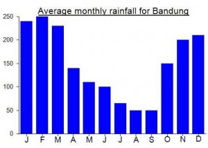
Local Average Monthly Rainfall (mm):
Location
Click on the blue arrow ![]() (top right) to see your current location on the map
(top right) to see your current location on the map
Origins and Meaning
Allegedly from ‘Pak Tua’ meaning ‘old man’ in Indonesian, referring to the fact that local legends tell of village elders meeting at the summit in centuries gone by. Also known to some local people as ‘Gunung Sepuh’ – ‘mountain of elders’.
Had a great but slightly extreme day out recently, exploring the hills on the western side of the Ciwidey road. We did both Masigit, the highest, and Tambakruyung, the most popular and best for views.
Just getting to Masigit is an adventure – ideally you need a trailbike or a 4WD. The tea plantation is quite beautiful, as usual first thing in the morning. The smell of tea as you pass the factory building is delightful. We were lucky with the trail because one of our team had been up there just a month ago so it was relatively clear, though the plantation fields near the forest entrance had already changed in just 4 weeks or so! If no groups have been up for months I imagine it would be quite tough until you reach the first peak, after which the trail is wide and clear and the vegetation up there simply doesn’t grow back as fast.
For Tambakruyung we had some navigation problems, as the old route from some years ago was blocked, and different people in the fields said different things and there were numerous unmarked junctions. After almost giving up one of our group found the new, and decent, trail up on the ridge to the right. This is clear and there are blue and occasionally red ribbons on branches. It’s easy to follow mostly and there are fabulous views!
Anyway we made it up in time and got back down before the rain started, so all was well. I definitely recommend these peaks to anyone who has done all the more popular ones. Thanks to Pepep and Abdul as usual!
Had an absolutely brilliant hike up Gunung Patuha yesterday. A full exploration of Kawah Saat, the highest crater, with Pepep and Abdul of the Gunung Institut in Bandung, experts on the history and mythology of the mountains in West Java.
We actually set off from Jakarta just after midnight, as I was determined to get some sunrise shots over Kawah Putih. Whereas Kawah Putih is a place where folk wander around and do pre-wedding photos, Kawah Saat, and the approach from Cipanganten in the tea plantations is a proper hike, although not official. Both access points are worth exploring, but the whole area is best avoided on weekends unless you love sitting in traffic!
We were at Cipanganten by around 4am and up at Puncak Sunan Ibu by 5.30am. This is not a popular approach so you really need local guides, especially when starting in the dark! The sunrise was incredible, and it was just us and a small group from Cirebon up there. It really is justifiably described as West Java’s Kelimutu when you are lucky with the weather.
We did a full circuit of Kawah Saat, an easy place to become lost in poor weather, so again a guide and GPS are very much advised. The weather was perfect and we spent half an hour down in the crater itself, chatting about Bujangga Manik. The contrast between that place and Kawah Putih just 1km away is stark! Very few who say they have been to Kawah Putih have any idea about this spot, a bit like the hordes who stomp up Kawah Ijen with no idea of Gunung Ijen-Merapi just 1km away.
Based on GPS readings, the south-west peak is the highest, at around 2,450m (GPS gave a little over that), but the finest viewpoint is on the north-west side where the cement pillar is.
We were back down in Cipanganten before noon. One of the best dayhikes in West Java, I think. Heading back to Jakarta was surreal with little sleep the night before and the weirdness of the new elevated toll road above us, like something post-apocalyptic, as the bright sun continued to burn across the sky, barely a cloud in sight all day.
It’s nice that things are slowly returning to normal, but travel by train from Jakarta remains a grey issue. The Primajasa buses to Garut and Tasik were certainly running again though, but the word is you have to pay double (nobody is allowed to sit next to another person so you’re paying for 2 seats).
(Done it in July 2015.)
Nice, easy but crowded on week-ends.
We climbed from the parking lot. You can find shortcuts in the forest between the shoelace road.
Note that the price for “foreigner” is now 75.000rp. 🙁
The area is frequently use as pre-wedding photography area. Entrance fee: Rp 150,000/car or Rp 5,000/motorcycle plus Rp.16,000 per person. Significant different entrance fee between car and motorcycle due to Forestry Administration discourage of using cars.
I quote it from http://wikitravel.org/en/Bandung at the last section (Get out), may be it useful for the readers.
Thanks for the informative article about Patuha. I’ll try to squeeze this one in to my java trip.
A very very easy one! One of the few peaks listed on the site that would be suitable for an adventurous family outing. From Jakarta I got a Cipaganti mini-bus to Bandung (just over two hours, they run approx from 5am til 9pm from various locations) and then an ojek for the 90 min ride via Ciwidey up to Kawah Putih. It’s a shame the peak has just under the required 1000m prominence to make it a Ribu – thanks to the fascinating Kawah Putih however it is definitely a worthy Spesial peak.