
Facts
- Elevation: 3,020 m (9,908 ft)
- Prominence: 2,427 m
- Ribu category:
 Sangat Tinggi
 - Province:
 Jawa Barat (West Java)
 - Coordinates: -6.7701, 106.9650
- Rating:

 (28 votes) Add your rating
 Loading...
 - Other names: Also called Gunung Agung in ancient times according to the Bujangga Manik Old Sundanese (Hindu) text.
- Eruptions: Gede 1747-48, 1761, 1832, 1840, 1843, 1845, 1847-48, 1852-53, 1866, 1870, 1886-88, 1891, 1899, 1909, 1947-49, 1956-57
- World Ribus ID: 69023
Photos


Bagging It!
This Ribu is one of the two peaks that form part of the famous Gede-Pangrango National Park. It is only 50 km drive from Indonesia’s capital city Jakarta, and is one of the most popular destinations in “The Puncak”, which is the area between Cisarua and Cibodas. Due to its proximity to Jakarta and Bandung, it sees over 50,000 visitors per year and there is actually a limit to how many climbers are allowed up each day. The most common starting point is at the entrance to the magnificent Cibodas Botanical Gardens where the Gede-Pangrango Park office is located (for permits, guides, porters and basic maps).
Most hikers’ destination in Gede-Pangrango National Park is actually Gunung Gede (2,962m), understandably so since the hike to Gede summit around the towering cliffs of its crater is a wonderful hiking experience, and offers extensive views of Pangrango, Salak, the Bandung area and on clear days you can see Gunung Karang in Banten Province, Jakarta, and the coastline of West Java. You can see Sumatra if you’re lucky. Pangrango itself is a dormant volcano with a forested summit, however for fit hikers a trek to both peaks can be done in a weekend with only one night’s camping. One Alfred Russel Wallace was certainly impressed, writing that ‘by far the most interesting incident in my visit to Java was a trip to the summit of the Pangrango and Gede Mountain’.
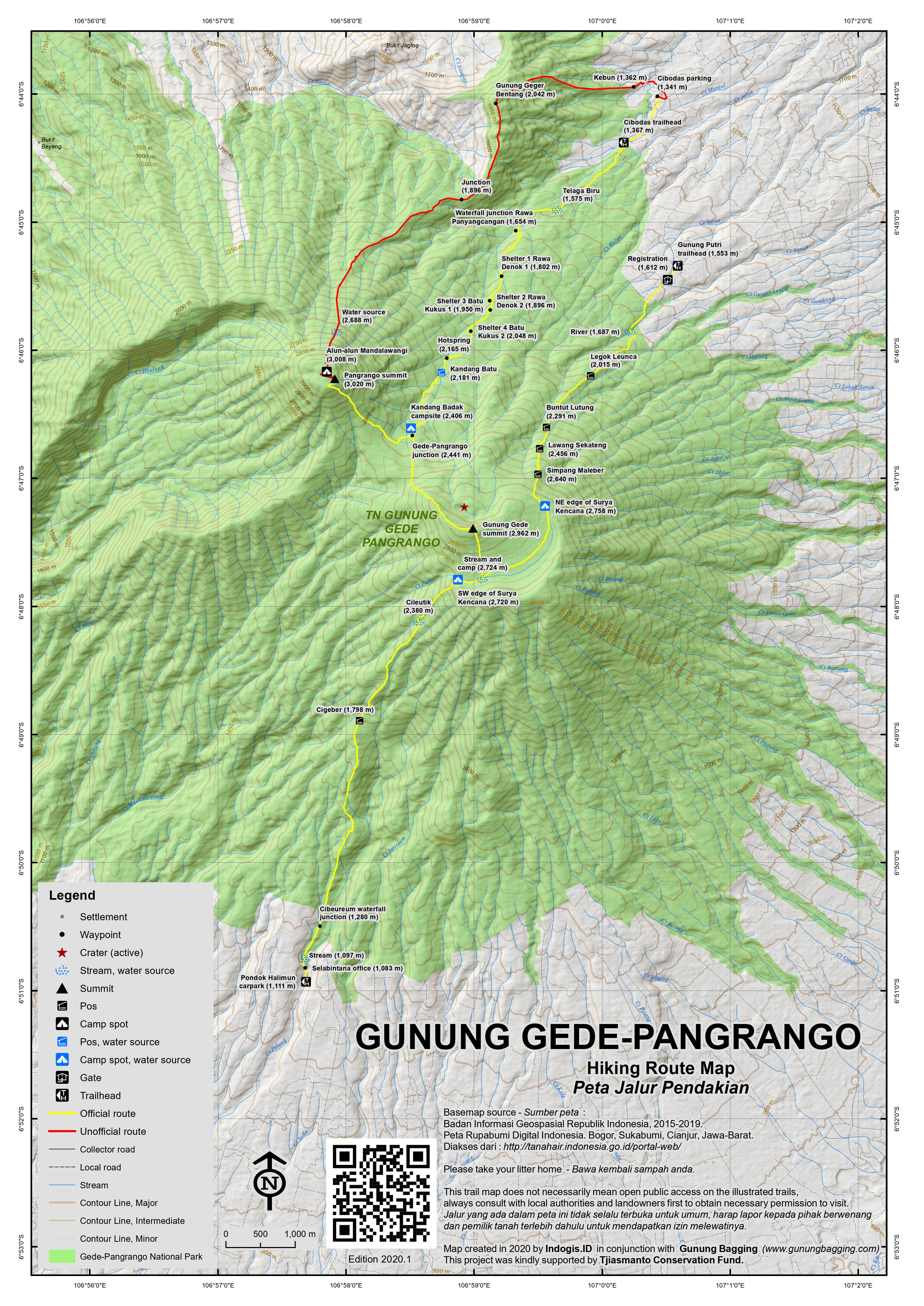
Cibodas route
From the National Park Office in Cibodas (1,250m), follow the track by the side of the botanical garden golf course to the gate post where the park staff check you have a permit and a guide or porter (1,367m). After 30 minutes from here along the track at 1,575m is Telaga Biru (blue lake) which lies to the left of the path.
Another 15 minutes and you will reach a large swamp area which has a wooden and concrete walkway across it. This is known as Rawa Gayonggong and it is good place for photos of Pangrango in clear weather. After that is a wooden hut and signposts known as Rawa Panyangcangan (1,654m) just before Cibeureum waterfall (which isn’t actually on the main path itself but makes a pleasant minor detour).
It is another 60-90 minutes from here via shelters Rawa Denok 1 (1,802m) and 2 (1,896m) and Batu Kukus 1 (1,950m) and 2 (2,048m) to the fantastic hot stream waterfall (2,165m), which you cross with the use of the rope and poles to hold onto. The water is incredibly hot even though it has travelled quite a long way already out of the crater. Just beyond the hot water is a rather unattractive cement hut and another steaming stream.
From the hot springs, it is about 15 minutes to reach the camping area of Kandang Batu (2,181m), which is an option for camping only for those who are novice hikers. It has a source of water, but really you should hike on another 30 to 45 minutes – via an impressive small waterfall called Panca Weuleuh – to Kandang Badak camping site (2,406m), which is a relatively flat forest area in the col between Pangrango (northwest) and Gede (Southeast). This is the most popular camping area, since it offer the option to climb both peaks and has a good source of water. There is even sometimes a small warung (snack stall) here. Total hiking time so far is about 3 hours for fit hikers, but perhaps 4 or 5 hours for those who are less regular hikers.
The recommended option if you want to climb both peaks in one weekend is to pitch your tent here, and then proceed directly to climb Pangrango. You can leave you porter or guide to look after your tent, although there are not likely to be any security concerns. It is approximately a 3 hour round trip to climb Pangrango from Kandang Badak. Just a few minutes on the path above the Kandang Badak campsite, you will reach a T- junction (2,441m) with the trail between Gede and Pangrango and a signpost (right for Pangrango, left for Gede). Take a right and follow the steep forested trail up to the top of Pangrango (3,020m). The trail is crossed by some large fallen trees and the path becomes rutted and it is easier to zig-zag up the trail with the lesser gradient rather than taking all the short cuts.
From the signposts it takes about 1.5 to 2 hours to reach the top where there is a wooden structure and cement pillar at the top and some reasonable views through the tree branches to the Gede crater. At 3,020m, Pangrango is just 58 metres higher than neighbouring Gunung Gede. The pillar is from the Dutch colonial era and constructed as part of early efforts to properly map Java and other islands. If you look on the back of it you will see it has a numbered marker – 142. The best place to camp on Pangrango is just five minutes beyond the highest point at a lovely, open grassy area called Alun-alun Mandalawangi, but there is no source of water. The main reason to camp here would be for the relative peace and quiet since most people prefer camping at Kandang Badak or on Gede.
After spending the night at Kandang Badak, you should get up early and complete the much easier climb to the crater rim and the summit of Gunung Gede (2,962m). From Kandang Badak, follow the obvious route onto the shoulder of Gede. You shouldn’t have problems if you stay to the trail because it is a very popular hike and there will be many other hikers around. As you start to climb higher in the forest, you reach a point where there are some metal posts with wire strung between them as the trail gets markedly steeper up a rocky outcrop. It’s easy to climb this initial part, but above that the rock slop is very steep and some people may not be comfortable hauling themselves up this steep section. If you don’t want to do this, just as you reach the start of the metal bars and rope, there is a path in a deep gully that curves off to the left of the trail. Take this route since it is an easy and safe alternative route. At very least, look out for this route on your descent.
The smell of sulphur becomes stronger and the trail nears the edge of the crater (on the left of the path). As you emerge from the forest you climb gently up along the crater rim and the views get better and better as you climb. Be careful not cross the roped path because the crater edge cliffs are high and sheer. There is a flag at the top and fantastic views in all directions – Gede is a much better viewpoint than the forested Pangrango peak. Many people camp on and around the summit of Gede, and at least there is no hike for sunrise, but there is also no source of water. From the summit to the south is the wonderful and atmospheric Surya Kencana meadow (2,750m, less than one hour beyond Gede summit), which is a great place for a second night’s camping if you have time (or your first night if you didn’t bother to summit Pangrango). On the other side of the meadow is the forested Gunung Gumuruh, at 2,927m the third highest peak in the area.
From Surya Kencana you can follow the long, significantly eroded trail round to Gunung Putri village (1,553m) and take an ojek (motorbike taxi) back to Cibodas. Allow 4-5 hours to reach Gunung Putri from Surya Kencana. The alternative is to simply return the same way, of course.
Gunung Putri route
The Gunung Putri route provides excellent access to Gede and Surya Kencana. The trail leads via Legok Leunca (2,015m), Buntut Lutung (2,291m), Lawang Sekateng (2,456m), Simpang Maleber (2,640m) before reaching the north-eastern edge of Surya Kencana.
Selabintana, Sukabumi route
There is also access to Gede-Pangrango from the south at Pondok Halimun (1,111m), Selabintana – near Sukabumi. Because it is further away from Jakarta, this is the least popular of the three routes and therefore far fewer people use the trail.
It is a long 11km from the National Park offices to Surya Kencana camping area below Gede summit and there are a lot of leeches on the lower part of this trail! It makes a great trip if you don’t mind driving that little bit further round to Sukabumi and also if you enjoy a bit more solitude.
The trail leads via Cigeber (1,798m) and Cileutik (2,380m) before reaching the south-west edge of Surya Kencana. Allow approximately 7-8 hours to reach Surya Kencana from the starting point.
Day-hikes
It is technically possible to hike either Gede or Pangrango as a long day-hike from the Cibodas entrance starting at 6am, and people are known to do this, although the legality of it is very much a grey area. Many locals visit the Cibeureum waterfall as part of a half-day out, and as this is one hour along the same trail as the peaks it is possible to simply continue up the mountain. However, this option is not mentioned on the National Park website which only mentions the 2 days and 1 night camping option. You could try asking about this in advance via email, as turning up on the day might lead to disappointment if they tell you it is not allowed (although some hikers just say they want to visit the waterfall).
In 2018, one-day tickets are not purchased at the main office where you sign in for a 2-day trek (see below) but a little further on at the ticket office at 1,400m. Rather oddly, the main park office for 2-day tickets doesn’t open until 8am, but the one-day office opens at 6am. Ticket prices are around Rp12,000 for locals or KITAS/KITAP holders (Rp18,500 on public holidays or weekends) or Rp150,000 for foreigners (Rp240,000 on holidays/weekends).
Bagging Information by Daniel Quinn and Andy Dean, (updated September 2018).
Unofficial Geger Bentang route
There remains another old trail up from near Cibodas which leads via Gunung Geger Bentang (2,042m) and after dropping down into a minor vallye, continues straight up the side of Pangrango. This trail is probably overgrown because it is now for researchers only and the National Park has banned normal hikers from using it.
Lesser peaks north of Puncak Pass
The ridge north of Puncak Pass running roughly north-west to south-east has a few peaks worthy of exploration as part of a half-day hike. The range is known as Pegunungan Mega Mendung but it could equally well be seen as a continuation of the huge Gede-Pangrango massif.
The most northerly (and most popular) is Gunung Kencana (1,803m according to some sources including the summit signs but 1,796m according to the Bakosurtanal map) which is a very easy 45-minute hike from the isolated Warung Mang Unang (1,530m) lying in the higher reaches of a tea plantation several kilometres beyond the village of Cikoneng. To get there from Puncak Pass, register and take the track at the junction near Telaga Warna.
It takes around 40 minutes to reach the warung along bumpy tea plantation tracks, passing the presumably artificial lake of Telaga Saat and Cikoneng village where there is a small school in the middle of the tea plantation. There is a supposedly shorter but steeper approach from lower down the Puncak Pass at Kampung Arab but it is not recommended because it is likely to be far too narrow for cars and may be tough to navigate.
From the warung, follow the plantation track as it continues for a few more hundred metres (or take the narrow short-cut crossing through the tea field) to the registration point at the foot of a curious wooden staircase known as Tanjakan Sambalado (‘Chili Sauce Climb’, 1,591m). Take real care here on the spicy wooden staircase up to the Pos 1 sign (1,636m) and use the ground-level path on your descent.
Pos 2 (1,715m) is soon reached and is a great place to have a short rest as it has a wooden seat. The trail then turns leftwards along the pleasant forest ridge.
The summit has great views to Gede-Pangrango and Gunung Salak, and the tea plantations are themselves incredibly photogenic, especially on a clear morning with Gede-Pangrango looming over in the background.
There are two other named peaks in this range, but both would need to be hiked separately. 1 kilometre south-east of Gunung Kencana is the lower Gunung Luhur (1,727m). However, the highest on the entire ridge line is Gunung Lemo (1,872.7m according to the Bakosurtanal map) but few people hike it and it is overgrown and therefore with less views. It’s a couple of kilometres further south-east near the main road and might best be approached from Desa Ciloto near Telaga Warna at the top of Puncak Pass.
Trail Map
For a high quality PDF version of this and other trail maps, please download from our Trail Maps page.
Practicalities
- Getting there: For domestic flights from or to West Java, such as the airport in Bandung, we recommend Baolau. From Jakarta, there are plenty of buses to Bandung which go via Puncak and Cibodas. Travelling back into Jakarta on a Sunday is not recommended as the traffic is horrendous. You could go back via Cianjur and Padalarang but it’s quite a detour.
- Guides and GPS Tracks: Want a PDF version for your phone? Looking for a guide? Need GPS tracks and waypoints? Gunung Pangrango information pack can be downloaded here.
- Trip planning assistance: Would you like Gunung Bagging to personally help you in arranging your whole trip? Please contact us here.
- Permits: There are lots of restrictions. You must apply for a permit from the park office in Cibodas between two months and 2 days before your hike, although if you are paying the higher, foreign rate you can usually get a permit on the day you arrive. Note the office does not open until 8am which is rather inconvenient for an early start. You can phone them on 0263-512776. According to https://booking.gedepangrango.org/ the price in 2017 for entry for 2 days and 1 night (the maximum allowed) is Rp 29,000 for Indonesians (Rp34,000 at weekends and public holidays) and Rp320,000 for foreigners (Rp 470,000 at weekends and public holidays). You need a photocopy of your passport too. Unfortunately, the Park is closed for hiking in January, February, March, August, Idul Fitri and at any time when the management think there is going to be bad weather. Guides are ‘strongly advised’ for foreigners according to National Park “policy” and cost Rp 350,000 (2 days and 1 night) in September 2010. Porters cost 400,000 (2 days and 1 night) in November 2011. If you can speak some Indonesian, you can hopefully persuade the Park staff that you do not need a guide and only want a porter – at least the porters do something useful and carry a bag. It is possible to arrange your porter in advance and then proceed to the Park staff already organised with your porter (although you will still pay the Park staff for the porter and not the porter directly). Porters can be arranged at the Warung Edelweiss, which is a small warung (cafe) in the corner of the public car park just below the Park office and carpark. Ask for Pak Obik, who is arguably the fastest porter in Indonesia.
- Water sources: Available at much of the Cibodas trail as far as Kandang Badak, and Surya Kencana and at Cileutik (approximately 2,380m on the Selabintana trail).
- Accommodation: Try the Booking.com map above or use this link to search for suitable hotels, homestays, resorts and apartments for your trip.
- We recommend Safety Wing as travel insurance for overseas travellers and tourists hiking up to elevations not exceeding 4500 metres.
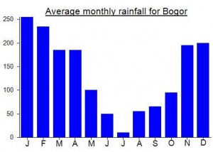
Local Average Monthly Rainfall (mm):
Location
Click on the blue arrow ![]() (top right) to see your current location on the map
(top right) to see your current location on the map
Origins and Meaning
(unclear). Rango could be a variant of an ancient word that suggests “panting” or “huffing and puffing” and thus pangrango might mean “that which huffs and puffs” i.e. emits smoke and ash during eruptions. (George Quinn, 2011)
Climbed Pangrango a few weeks ago on Saturday 4 October from Cipanas. Didn’t run, but aimed for a fast walk as wanted to do a decent pace and get it done in the morning. Started the hike a little after 3am once the overnight rain had stopped, and was surprised by how many groups were already on the trail. But there are plenty of passing opportunities on the wide stone trail and I and hit Pangrango summit around 630am. There were some good views of Gede from near the top, and the forest the whole hike is quite nice although the last 1.5km to the summit became fairly muddy (I suspect it was already muddy before the overnight rain). Coming down was fine, not much quicker than up for me as I always find descending stone paths to be hard on the knees and ankles. There were several warungs operating on the trail, with the highest at the pos below the hot springs (amazing they can carry so much stock that high up). Again a lot of people heading up the mountain as I descended, most heading to camp at Gede presumably. Was back down a bit before 10am and jumped on an Angkot to the main road to get to my hotel. At a reasonable pace one could definitely summit both Pangrango and Gede on the same day hike, but I wasn’t interested in doing that on this occasion.
The online booking page says that the hike is closed. Has it reopened yet?
As of 22 April 2025, the hike is opened again
Thanks for all the info on this page and in the comments! We hiked Gunung Gede on August 7, 2024; locals told us the park might close after the 15th or so. We are birdwatchers and weren’t planning to hike all the way, so we rather inadvertently avoided all the registration hassles — we entered the park at 5:20 am, but before the office opens at 6 no one seems to care if you start up the trail, quite a few people saw us walk through. Then the birding was slow so we decided to see how far we could get, made it up in 7 hours (with short birding stops) and down in 6, starting and ending in the dark with a flashlight. The day before we arrived a bit after six am and paid for both the Cibodas area tourism fee (12,000 for pedestrians at a gateway a bit before the park) and the day hiking ticket (165,000 rupiah for foreigners on a weekday), but missed a lot of bird activity starting after sunrise. We arrived at the park on Sunday and left Thursday — would say Tuesday/Wednesday /Thursday were much quieter than even Monday and definitely than the weekend. We’re active people in our 30s but not hardcore hikers — we just bike and walk where we live, maybe the world’s flattest country, and found this hike rather brutal. I hobbled down the last stairs and was relieved not to fall at any point, we both agreed it was the hardest hike we’d ever done. Worth it for the views and the very special volcano swiftlets at the top!
https://en.tempo.co/read/1773405/fire-burns-mount-gede-peak-hiking-trails-closed
Does anyone know if it’s reopened? The news page doesn’t even seem to mention there was a fire… https://gedepangrango.org/berita/
Fairly confident it will be open again by now. I would try booking in advance on the Park website. It will be closed in early 2024 as per usual though.
Info on the national park permissions and costs. We’re planning to hike Gunung Pangrango in a couple of days as a one day up and back thing, now that it has reopened. Fees are high. On weekends and holidays it’s Rp 470K for foreigners (including KITAS holders and diplomats) and Rp 34K for Indonesians. If you try to register on the website, they make you pay for two days (ie Rp 940K for foreigners), on the assumption you have to spend the night.
Chatting with the park and some basecamps, it’s OK to just do it in one day. They have to manually register us to only charge for one day, but it’s a flat fee of Rp 600K for foreigners and Rp 100K for Indonesians, including producing the good old health certificate. I wasn’t able to get anybody to budge on that price so I think it’s fixed, at least for now so soon after the reopening.
Great hike yesterday! Drastically cleaner than last year when I did Gede, thanks to the park only just reopening. And lovely that there were a relative handful of people out despite it being a public holiday.
We started at the Cibodas entrance and hiked up to the peak of Pangrango and then down the same way. Started at 6:30am, arrived at the peak at 12:00, and finished at 5:00pm. We had a fairly relaxed day overall though – 30 minute hangout at Kandang Badak, 60 minute lunch at the peak, 30 minutes chilling with our feet in the water at the hot stream (and another 30 minutes where we lost each other on split trails near the peak and had to mess around finding each other again!). So if we were aiming to get up and down as fast as reasonable, I think 8-9 hours is doable for a reasonably strong hiker who usually comes in close to GunungBagging’s times. There was also a group we ran into several times, who did both Gede and Pangrango peaks yesterday, taking about 9-10 hours in all. Definitely possible if you’re fit and experienced.
The permissions seem to be a bit wild after this reopening. We were fine because we paid the marked-up prices above and organized it in advance, but I did see that the local guide we organized it through had to hustle around several people and stations and pieces of paper much more than usual. I am told there are problems with the new registration system. The group that did both peaks said they arrived at the registration at 5:30am but were only finished with everything at 7am. Another group told us they spent two hours negotiating at the entrance and eventually managed to leave a deposit there in exchange for an assurance that their permissions would be taken care of when they got back down. Everyone in those groups was Indonesian and I believe they were trying to pay the official prices, so I’m guessing it was our overpaying that smoothed things over…
Still well worth it – it’s an incredibly beautiful park/trail. Just sharing info so people know what to expect!
During my searches for interesting places to visit near Sukabumi, I discovered a site on the edge of Gede-Pangrango, the south-west slopes of Pangrango at around 1,100m above sea level to be exact, called Konservasi Penangkaran Elang Jawa. Here is the grave – or at least a monument – for M.E.G Bartels (1871-1936) who gave his name to the Javan hawk-eagle (Nisaetus bartelsi).
re costs – they can charge what they like, its their land. Have you tried hiking up hills on private estates in Scotland or Australia? No way Jose. Gunung Gede-Panggerango is an extremely important biosphere reserve (https://en.unesco.org/biosphere/aspac/cibodas), which none of you seem to care about, & needs heaps of funding – not a place for idiots to cheat the locals by saying they are going to the waterfall then boast about how clever they were climbing the mountains.
Sorry but the developing world is not just a backyard for overpaid whiteys to swan around in & pass disparaging comments about local people’s religion and logic (in comments below). I can think of a heap of things to say about the logic and intelligence of people who voted for Boris or Donald, and none of them are complimentary. So please, enjoy the place and understand that you are very privileged to be where you are & do what you are doing. And help support these places that you like to run around in, instead of cheating them.
Thanks for your comment.
“The can charge what they like”‘. They, the authorities, can indeed charge whatever they want. Any figure at all. But the real question is whether they should.
“Have you tried hiking up hills on private estates in Scotland or Australia?” Yes I have. Hundreds of times. In Scotland free public access to all of the hills and mountains is enshrined in law. You are not charged a fee, discriminated against, made to feel unwelcome, perceived to have more chance of carrying Covid simply because you are not ‘local’, or forced to take a guide. You get to the mountain you want to climb and you climb it. Along with Scandinavia, Scotland has some of the most egalitarian access laws on Earth. And thus an Indonesian hiker would not be forced to take a guide and charged 30 times more than a Scotsman and then asked for a tip afterwards. As for Australia, I have no idea. Obviously with rights come responsibilities.
“Gunung Gede-Panggerango is an extremely important biosphere reserve…which none of you seem to care about, & needs heaps of funding” Yes it is and it does need caring for. But foreign feet do not cause more harm than Indonesian feet. Indeed, although things are slowly improving, the littering is still part and parcel of the Indonesian hiking experience. And the bureaucracy can be unnecessarily oppressive, again throughout Indonesia, particularly in National Parks. But the segregationist pricing policies are indicative of a deeply-held and harmful mindset based on stereotypes which doesn’t ultimately help either party or the relationship between them. It is especially hard on people who have lived locally for decades yet look ‘foreign’ and are therefore treated differently.
Spend a few months or years living in the place and you might change your tune when you witness discrimination based on skin colour or ethnicity, which you surely would – not just towards ‘foreign’ folk (who really are regularly seen as walking ATMs even if they are volunteers or low-paid English teachers) but also towards those from the eastern islands in Indonesia. The latter especially is horrendous and seems so ingrained it will take a long time to fix.
The other issue is being sure of where the money actually goes. I think many who have the means would be happy, not to be charged several times more than the local price which does create a segregationist atmosphere, but to donate a sum of their choosing towards the upkeep of the park. This includes wealthy Indonesians, of which there are many. The central issue though is that it is far from certain that the donated money would actually be spent properly on worthwhile projects. Funds for projects through Indonesia frequently vanish or get siphoned off. Again, this issue is widespread and will take a long time to fix. Just do some research on the issue and your jaw will drop. Logic does play a role, specifically the development of an education system that values critical thinking skills and teaches that stealing from the cash register might seem like a good idea right here and right now but will have a broader impact on many others over the medium-term.
” I can think of a heap of things to say about the logic and intelligence of people who voted for Boris or Donald, and none of them are complimentary”. Me too, feel free to fire away, preferably on a site relating to the impact of their policies.
Had a great quick hike up Gunung Kencana yesterday morning. Well worth a half-day out from Jakarta.
We were a bit concerned at first about the frequently diabolical traffic up Puncak Pass, especially with it being Idul Adha, but it turned out to be not too bad on the way up and almost empty on the way back down!
We set off from Jakarta at around 230am, reached Telaga Warna near the top of Puncak Pass at around 5am. There’s a security booth there and a tea plantation track with a barrier. The guard asked us to sign the book and charged us 50,000 total for the two of us and the car.
Almost immediately after turning off you feel you are a thousand miles from the Puncak Pass, with barely any signs of civilization. We saw a couple of luwak (civet cats) run across the track. There are a couple of places where the track is extra-bumpy, but a Fortuner could handle it all quite easily. Probably not a good idea during the rainy season though. How many kilometres is it? I would guess around 8 or so to the trailhead from the main road at Puncak, with the school at Cikoneng being past halfway.
We parked just beyond the warung – there’s plenty of space for motorbikes and perhaps enough space for 3 cars. Paid 25,000 for parking. From here it’s a 10-15min walk up to the end of the track and where you register and pay yet again (Rp20,000 each). They may ask you to leave your ID with them and pick it up on your return.
The wooden staircase thing is quite a feat of engineering, but you do need to take care here as naturally some sections of the wood are stronger than other sections. The view at the summit just after sunrise was superb for a place so close to Jakarta. There must be enough space for 20 tents or so, and there were about 5 or 6 tents up there – it is probably busier than this, especially over weekends.
A puppy at the summit followed us back down afterwards – presumably a farm dog! The view over the tea plantation to Gede-Pangrango is amazing, even from the track back to Puncak itself. Eary mornings recommended. From the main road we were back in Jakarta in under 90 minutes – a record for me. Nice to see cyclists out and about, enjoying a relatively traffic-free morning.
You really don’t need a guide for Gunung Kencana, but if you want to check it is open, call or WA the basecamp on 0857 2092 5972.
Climbed Gunung Gede Midweek . Wonderful hike 4.5 hrs up 3.5 down. Met a few monkeys half way up and at the peak we were the only 2 people. Absail down on the way back by taking alternitif route with fixed ropes… visited big waterfall on the way down for refreshing power shower
On entrance at 7 am we told the ticket chap we wanted to visit waterfall and he asked for 240 000 each. I said it’s mid week so should be 150000 each. Finally he offered us student tickets at 115000 each ….I was happy being over fifty,
Wonderful hike. Beautiful forest.
The trail is never too steep, still very efficient, much better than Cikurai or Buntur to name my recent experiences
The article was written last year. I just wanna ask if the price for KITAS holders are the same this year? Did they change any rate? Any idea. Thanx
Interesting correspondence from hiker and trail runner Mykhailo who explored some remote parts of the range recently including the southwestern side and Puncak Masigit. He saw large animal droppings (from the images probably a ‘big cat’ such as a panther) plus some pitcher plants which are increasingly rare on the mountains of Java.
Just back from a wander round the distant foothills to the north of Gede-Pangrango. There are a couple of minor peaks that folk mention from time to time that I have only today visited. The info below may be of some use for folk wanting to do something very easy near Jakarta, but neither is, in my opinion, special enough to have its own page on Gunung Bagging.
First up, Gunung Batu Jonggol, an 875m (apparently) rock cliff a fair distance south of Jonggol. It can be approached from either Bekasi or Citeureup (off the Jakarta-Bogor toll road). I took the latter option, getting a Grab all the way from Jakarta to the gunung. Rp225,000. As per usual, the Grab driver had no credit on his toll card. Eventually we agreed to just take the regular roads. This added 30 minutes to the journey so a good 2hr 30min total. The first stretch was horrible, the usual dirty, clogged chaos that is typical of West Java and takes an astounding lack of intelligence to create, but once we started climbing up into the hills it was lovely to see rice paddies and rivers and a few small hills. Jakarta has been the city with the worst air pollution in the world this summer, and today the haze was horrid too. Poor visibility. When Batu Jonggol suddenly came into view I was rather impressed – it is a very striking, steep cliff. There’s a car park and couple of warungs at about 630mdpl, so it isn’t very far to the top – probably less than an hour. Unfortunately, as per usual, there was a barrier in place (not a literal one, but one in the form of an Indonesian). Out jumped a character to inform that the trail was closed and I couldn’t climb it. He pointed at a small group of students who had also arrived wanting to climb but were either encouraged not to or outright denied entry. It turned out after some asking around that the trail was being cleaned. Well, that’s good, but no reason to close a trail, especially not on a weekend when the vast majority of visitors would come here wanting to hike. But, who am I to question a local person’s logic, or lack of? It’s very difficult to find this sort of information out in advance which is immensely frustrating for those who have spent time and money getting here to be told ‘tidak boleh’. So, I took a few photos and had a few taken of me by some cyclists from Karawang. Admittedly the sky was so hazy that the views would not be good on a day like today. Best time would be rainy season, after the rain has stopped.
So I got an ojek to Gunung Pancar. Not far as the crow flies but nearly an hour along narrow village roads. As agreed I paid the ojek guy Rp100,000 for this – a pretty fair deal, especially considering the fuel would be less than Rp20,000. But, naturally, he looks at the two Rp50,000 notes as if to say, ‘What is this? This is not what we agreed’. He asks for more. I refuse. He leaves. Another of Indonesia’s many take-take-takers.
At the highest point of the road, at around 600m, there are a couple of warungs, but no obvious sign for the trail to the peak of Gunung Pancar. It seems that almost everyone that talks about Gunung Pancar actually means the large cluster of warungs lower down on the west side where there are hot springs and camping spots and ‘hutan pinus’ (pine forest). I asked a guy in the warung and sure enough there is a trail up behind one of them to the peak of Gunung Pancar (a little over 800m, the Bako map suggests 854m). I presumed this was a secondary route and I would meet a more major trail coming up from another direction at the peak itself. It took only 35 minutes to reach the top, on a mixture of terrain, including some cement steps and bamboo rails. There were no other hikers, but halfway up there was a chap at a warung and at the top there was an old couple at another warung. The peak is covered in simple structures including a mosque. I was amazed to see no other hikers at all. Even more amazed to find that the trail I was on was indeed the main trail up. After a few photos (there are only a few partial views of the land below) I was back down in 25 minutes. I walked down the road to what everyone else calls Gunung Pancar (the main area of warungs etc) and got an ojek to Bojong Gede train station. I have to say it was great approaching Pancar from the east because it meant I didn’t have to argue with the ticket folk at the entrance booth over whether I should pay the local or foreign rate (something that sours nearly ever trip in Indonesia for us foreigners who live here and pay taxes here). Indeed, I paid nothing. Whether or not you would want to get a car up the Pancar road from the east or not is another question – steep, narrow and rocky in places.
In short, Batu Jonggol would be ok if you did it very, very early or got lucky with the haze. Pancar is alright too, being the closest bit of ‘proper nature’ to Jakarta, but less good for views. Not a bad day out from Jakarta, but obviously nowhere near as fantastic as the larger ones, or even Parang and Bongkok (which are stunning, and are bit further away from Jakarta’s disgustingly polluted skies).
Just back from a mission up Pangrango for the national holiday (11 Sept, 2018). We (Amy, Dan, Ben, Trevor, Rob) did a one-day, up-and-back mission (GPS track posted). Beautiful sunny day with dry-season conditions. Pretty much perfect. We started in the parking lot/park office area in Cibodas at about 7 am. There are plenty of warungs for food/water should you need it. Hiking past the ticket booth, we were flagged over for payment. We told them we were going to the waterfall, which, by all accounts is the thing to do. If you say you are going to the summit, that apparently complicates matters significantly. Just say you are going to the waterfall (most people there are going to the waterfall). With that as our premise, four of us have KITAS/KITAP status, so we paid the national rate of 18,500 Rp; one did not and paid the outrageous bule (foreigner) price of 240,000 Rp (not a typo). If you have a KITAS/KITAP, bring it with you!
Once on the trail, it’s straight forward, and virtually impossible to get lost. Absolutely no guide required. The first part of the trail leads to all points up: waterfall, summit of Gunung Gede, and summit of Gunung Pangrango. The waterfall is a popular casual hike, with most people around you doing that section. After the very obvious and signed intersection/turn-off (right = waterfall, left = Gede/Pangrango), there is a good long stretch until the next very obvious/signed intersection (left = Gede, right = Pangrango). Up to that point, the trail is rather civilized and quite enjoyable. After the turn-off to Pangrango, the trail gets much rougher and steeper and starts resembling a jungle-gym obstacle course – all doable of course, but does require some ability and stamina to climb around and over large roots, stumps, and logs. The trail for the most part is forested all the way (very nice forest!), with some nice views of Gede as you approach the summit.
The summit itself is forested as well, but has a great view of Gede. If you have the time and energy, a worthwhile side mission from the summit is to continue from the summit (look for a trail going down in the opposite direction to where you came up – or see GPS track), down a trail to an alpine meadow near the summit, known locally as Alun-alun Mandalawangi. It is less than 10 mins walk down to the meadow. Very nice spot to have lunch in the sun at 3000 m!
Hiking times: carpark to summit = 4.5 hrs, at summit = 1 hr, descent = 3.5 hrs; total car to car = 9 hrs. (these were the “average” times for 3 of us; one was much faster; one was much slower….so gauge accordingly; range could easily be 8 to 12 hours, all in, depending on fitness)
All in all, a great day hike on a nice day, but is moderately strenuous and requires decent fitness to enjoy. Parking lot = 1300 m, summit = 3019 m, meaning about 1700 m climb (and descent) – not a cakewalk by any means. The descent is classically hard on the knees, making it almost as exhausting as the ascent. Indeed the great Gunung debate: what is harder….the climb, or descent?
Tip: the traffic between Ciawi and Puncak is famous for being horrendous, and can add many many hours to your day. Do everything you can to avoid weekends, holidays, and peak traffic times. Starting in Jakarta/Bogor in the wee hours of the morning to arrive at the trailhead for 5 or 6 am is a good option.
A great hike indeed. I saw a Javan whistling thrush on the way back down. Very common but what a beautiful dark blue colour.
The traffic was hell as usual beyond Bogor, with two lanes trying to get into one lane. We also had an accident when one of our group dashed out for ‘buang air kecil’ and got hit by a motorbike coming on the inside of a bus. They were both fine, amazingly, but just shows you how you have to expect the unexpected on the roads at all times. If there are any rules they are all broken anyway!
Sad to see a couple of Saudi Arabian flags, both at the side of the road and being carried by trekkers. It was Islamic New Year, but quite why anyone sane would wish to emulate or support Saudi Arabian culture is utterly mystifying.
I last reached the peak here in 2009 when I was on a Java Lava group trip to Gede. I decided to quickly bag Pangrango before following them up Gede and then down to camp at Surya Kencana. A long day, but easily done if you start early. Nice to finally visit Alun-alun Mandalawangi which was a beautiful spot to lie down in the sun!
I went on top of Gede yesterday. At the entrance in cipodas someone asked where I want to go. I told him “national park”. He asked ” waterfall” and I said YES. So I got charged 165000 and no one told me I need a guide. So in would recommend, try the same! On the peak I decided to descend to cipanas, thanks to the map someone provided. Liked the hike! It is just painful to reach and leave that place. I guess it is what it is with that traffic here 😉
I don’t see any other comments so I thought Id share my thoughts about running Gede-Pangrango. My main two concerns were 1) Water and 2) distance. I can confirm that both of these are within reason. There are enough water stops on the route and at the camp ground before the Gede Pangrango intersection they have food, and hot tea and noodles!
The run from the entrance to Gede Summit and back is about 22km, I definitely wouldnt say its a good running route: the road is mostly rocks and there are lots of steps so its a bit too uneven for ideal running (turned my ankle more than once trying). The water stops are well marked and I would definitely recommend using the following map for the run https://drive.google.com/file/d/0Bz2T9yUCAtSGRmtRNTY4b2lqbVk/view.
Finally, I did set out thinking about running both summits. I think its doable in a day (I “ran” for about 5 hours to complete the single summit), I don’t however, think it would be much fun 🙂 The Pangrango summit appears to be completely closed canopy and its a pretty straight shoot up a very steep slope…
One last comment to those who keep bringing up the difference in park entry costs. 1) Its 240,000 which is at the time I write this about $20 so definitely not a big deal, and 2) more importantly is completely in line with the difference in incomes between Indonesians and say Americans (but you could pick any developed economy). Unless you’re about to gift the difference in your salary to a charity then stop complaining!
Thanks for your comment. However your insistence that differential pricing is not an important issue is perhaps a reflection of your own circumstamces and ignorance of what many ‘westerners’ actually live on – eg many folk from the west are especially saddled with student debt – debt pushed in their direction from their parents’ generation. Also not taking into account that it is local hikers that need to be cleaned up after rather than non-Indonesians.
I am British and many Indonesian tourists that visit the UK are richer than me. Is it therefore ok to force them to pay more to visit, say, the English Lake District? Answer : no it isn’t.
$20 is not a big deal for you but definitely not for most people in this world. Please don’t generalize. You sound like only people from America and developed countries are the ones who travel. Should other countries charge Indonesians 10 times more the ticket price when they come to their countries? Indonesia is the only country that I have ever been charges foreigners such ridiculous proportion.
According to https://booking.gedepangrango.org/ the price for entry for 2 days and 1 night is Rp 29,000 for locals (Rp34,000 at weekends and public holidays) and Rp320,000 for foreigners (Rp 470,000 at weekends and public holidays). Nothing like a bit of good old fashioned ‘us and them’ discrimination – something Indonesians would be rightly appalled at were they to encounter it in, say, London. That said, any foreigners with a KITAS and basic Bahasa Indonesia skills ought to be able to to get the local rate. It’s still ludicrous though, and may be indicative of increasing bureaucracy in Indonesia for something as simple as wanting to climb a mountain.
Climbed Gede yesterday. Up and back in a day. It was a Saturday, which ordinarily is not advisable because of the crowds, and the infamous Puncak weekend traffic chaos. However, we are in the middle of Ramadan, which resulted in virtually “no people”. We had the summit to ourselves, and traffic was a non-issue. We saw less than half a dozen people on the way up. In addition to few people, there were no rangers or officials of any kind anywhere, meaning no one stopped us for any reason (i.e., no permits, payments, etc). Highly recommended during this Ramadan period! Hiking stats: left parking at 6 am, at the top at 11 am, started descent at 11:30 am, back at parking 3 pm. Total time, up and down, all in: 9 hrs. It’s a big day, have to keep moving, hard on the knees coming down, but definitely doable in a day for fit hikers
Hi Rob,
Great to know about your hiker free experience during Ramadan. it is indeed a great season to hike peaks!
Do you have any idea of the rates applied if you want to stay the night, especially for Bule (I see you didnt see anybody, but maybe there was some published rates? I have heard they changed on May 1st… but i am not sure what the new tariff is.
Thanks in advance for your input. Happy hiking!
Hi Oriane, sorry, I have no idea. Like I say, we didn’t see or bump into any officials. all the posts and regular places you might see someone like that were boarded up. In terms of camping, again, there was no one running around collecting fees, so I would imagine if you go now, you wouldn’t pay anything even for camping. ??
Hi Oriane,
We are preparing for a climb soon, and we learned that they just hiked the rates for bules to 480,000! This is with or without a KITAS. Crazy.
Matt
Im not a big fan of hiring porters and guides and i often prefer the lesser traveled route even if its not quite as well kept or aesthetically pleasing. Would climbing from Pondok Halimun (1,100m) potentially overcome the needs for permit/guide/porters?
Will be in Jakarta with a friend and am thinking to do a budget trek up Gede and Pangrango on 1-2 April 2016. Anybody has a guide to recommend?
Thank you.
Hallo Paul,
Nice to see about your coming to Jakarta at the next April. Gede and Pangrango is good mountain for hiking, and close to Jakarta (about 3 hours). April is good time for trekking because the gate is already be opened at that time and still fresh. I can help you to manage your trekking there and I did for several times in manage the trekking trip in Mount Gede and Mount Pangrango. If you need information further, please contact me HP or WhatsApp +6282315243061 or my email edwardbalandua@gmail.com
rental perlengkapan camping di gunung, rental peralatan mendaki, rental peralatan gunung, rental camping and hiking,rental tenda gunung, rental hiking camping, cp : NICE CAMP 08128083576 pin bbm 2856ED42, please…
Just to confirm, the park is always closed in August? Went to the website but everything is in bahasa and I don’t understand bahasa
I climbed Pangrango over the weekend.Left jakarta midday saturday and arrived at Cibodas gardens at 5 PM .had a stroll around and a look at the mountain.
Checked into Ubud Bali Guesthouse (150,000) had tasty dinner of smoked chicken and fish and 2 Bintangs
Got up at 4 Am and drove up to the Cibodas car park ..Many people about and food stalls open . had a coffee and Nasi goring then hit the trail. Still dark but a bright half moon . soon found myself walking across a golf course and into a farmers field …Asked a workman and im going wrong way! back down the hill ..i missed the entrance a sharp right Before the golf club house.
reached park entrance at 5:30 Park rangers tried to sell me an entrance ticket for 150,000 and i noted locals were paying only 11,000 so I pulled out 65,000 from my pocket rangers seemed happy .( no need for permits, guides ,passport Blah Blah)
Trail very quiet for 2 hours only saw a few hikers and Wild birds until after the hot springs (watch it very slippery) were there was a huge campsite Kandang Badak which i reached after 3 hours . Lots of indonesian students eating noodles but all very friendly
2 more hours later i am at the Pangrango peak(less than five hour total from Park gate) Eat my tin of Tuna and Shared My Kendall Mint cake with other hikers and headed down . Took 3 hours back down to waterfall and a refreshing shower!!
A fair day hike for the average level of fitness gets very Rooty and lots of tree trunks to crawl under or climb over as you near the Peak but a damn good weekend escape from Jakarta and a Good time to do it before Rains start
Am i correct to understand that guides and/or porters are not mandatory if I’m doing the climb alone and within 1 day?
Update September 2013:
Gunung Putri is closed “at least until 2014”.
We only had to pay the special Westerners fee, nobody tried to force porters or guides on us.
I wish the two shifts of 4 pegawais doing nothing but collecting money would do something useful and stay at Badak or the peak at least on weekends. These beautiful places are garbage dumps that cast shame on Indonesia.
after a very rough start to my trip i managed to bag pangrango and also gede last friday and saturday.what a brilliant mountain range.i really enjoyed the hike up pangrango.and gede must be one of the nicer craters i have been to. so heres the details of my trip that i hope might help fellow travellers .
i flew into jakarta from hong kong where i live at 5.30am .basically to cut a long story short i found myself 2 hours later in ciawi just up the road from bogor needing to get money out. after trying numerous atm machines that didnt support a hong kong card and not having a money changer open that early in the morning i took a ankot 10 mintues down the road to a bank that would open soon. i get into the ankot and some local chap jumps in and pushes up against me.at the time i thought he was unusually very close to me but then in a ankot where its a 6 seater that crams 20 people i just assumed its normal.then this girl sitting opposite strikes up a a conversation with me and she seem very helpful telling me which bank to go to.during this 10 minute ride the guy gets off. then i arrive at the bank and put my hand into my beltbag that i had around my waist to find my money pouch and iphone was missing.then it all clicked.girl distracting me while very close guy slips his hand in my beltbag and take whatever he can get.as i realise i have just been scammed i start freaking out realising that i cant even call anybody and have very little money and no way of drawing money out. luckily he didnt steal my wallet with credit cards or passport. so totally fed up i get the next direct bus to the airport and i am prepared to catch whatever the next flight is out of there.after arrving at the airport i find a internet and mange to contact my wife through facebook to cancel my phone and luckily for me dan( gunung bagging founder) who lives in jakarta is online. so i end up staying the night with dan and after recovering my nerves i decide that i have to at least try and make the trip a success.luckily for me dan speaks bhasa well so we made a trip to the local police station to get a police report of my stolen items for travel insurance purposes.dealing with the indonesian police is something you should avoid but the only problems we had were they couldnt get my name right on the report. for some reason there computer wouldnt let them put the letter G on the end of my name which might end up costing me any chance of a claim.
i still had alot of hiccups after this. the usual getting ripped off because im white.totaly useless taxi drivers with dodgy meters( i think they are called jumping horse meters).they also almost never know where they are going.horrendous traffic in and around jakarta. i am happy to bag pangrango but i will never return due to the stress of getting there. that road from bogor up to puncak is almost gridlocked. after half an hour of not moving 1 meter i gave up and hired a ojek to take me back.be very careful with your money around ciawi junction. after talking to the locals up in cibodas they said its a notorious area for pickpocketing.even they have lost money there.
the hike itself was brillant.they have a quota system and you are supposed to book in advance but the park office told me that is only for locals and that foreingers will always be welcomed.which basically translates to ” theres no way we will turn down the chance to fleece you of your money”
avoid weekends up there. on the friday it was fine.but i counted over 50 tents( and 50 blaring radios) at kandang badak on the saturday and judging by the amount of people i passed on the way down i think their quota system might be faulty.
it took me 5.5 hours to reach the summit of pangrango and then another 3.5 hours to go back down and then back up to gede.i would make the extra effort to camp up on gede to get away from the noise from the local back at kandang badak.i hired a porter.his name was dede and hes the quickest i have even seen.he was great.also my guide was a nice chap.andre was his name.make sure you let them know in no uncertain terms that you are paying to climb both mountains and not one.they will try the 2 mountains must pay twice trick.you are already paying way over the local price so dont give them more.
i had to go up and down the cibodas route because the putri route is closed for restoration.
i have been to indonesia alot and this trip has me thinking if the joy of standing on top of a volcano is worth all the crap you have to put up with.nothing comes easy in indonesia.i get the feeling that just going down the road to buy milk would likely ruin your day. i think dan deserves a medal for sticking it out and going to all these remote places.you wont find a more beautiful and yet frustrating place than indonesia.trying to go it alone without speaking the language is near impossible.still give me that over china anyday.
The ideal route to take is from Gunung Putri to Cibodas, not the contrary to it. Why? Gunung putri is the village that quite far away from main/province road, thus almost impossible to find the bus or any public transportation, unless you want to spend more time to walk down to town (Cipanas) for another +/- 7Km. Secondly, you will get a “full package”; More challenging track (waterless, steeper, no “stair-like” stepping stone), but you will get a shorter track, because you just have to stop at Suryakencana savanna, a huge camping area (50 hectares) to make a tent, rest, enjoy the savanna & valley’s view before you get to the Gede peak in the next morning then go down to Cibodas entrance.
If you start from Cibodas, chances are you build a tent at Kandang Badak, not a large place although it has plenty of water, struggling with tiny space between someone else’s tent right next to yours. You won’t find a great view since the place surrounded by high trees. If you want to skip this, you won’t find any comfortable area to make a tent until you get at Gede peak (+/- 3 hours distance). Some hikers make the peak as a final destination since they don’t want to spend more energy to go down to Suryakencana and get back to the peak to go home via the same track.
Does anyone know if the Cibodas entrance is still closed for renovation?
Both TNGP entrance (Cibodas & Gunung Putri) are closed from January until March and also whole month of August every year.
The Gunungputri approach is less attractive for it is water-less, forest all around and steep almost all the way up. Until you get into the Suriakencana savanna valley. Plenty of water and literally good for hundreds of tents. Experience a full moon over there and you would come back. The famous G Gede peak is 40 minutes further up.
reached the summit of Gede on 8th Dec 2012. Went up by the Cipanas route and came down by the Cibodas route “quietly”.
The Cipanas route(Gunung Putri) started with a walk through farms and it was very pleasant. My guide called it a bonus :).
The Cibadas route while passing through hot spring and waterfalls at the upper reach, involve a one hour walk on stone pathway at the lower reach(entrance) which is tiring and you need walk carefully as it may get slippery.
Went there on Thursday, got the permit issued on the following morning and started the hike up. just have to pay the guide and the porters – They provide their own tent and equipment for their own use.
Apparently, the Cibodas entrance is currently closed for hiking until April 2013 for renovation. However, it is still open to the public for recreation at the waterfall but not beyond it.
Anyone have contacts for guides for Gede? I’ve used Latif before but his number/email don’t seem to be working. Any help is much appreciated!
Hi Paul. Apparently Gede-Pangrango is closed at the moment due to the risk of forest fires.
I’m going to hike Gede/Pangrango on July 2012 after SIMAK UI , anyone wanna join?
Latif – who is also a guide for Salak – is now a guide for Gede/Pangrango. Similar price to the official Taman Nasional guides. He has a relationship with the Park authorities so you might want to take Latif and his friends as your guide instead of a random guy at the park office. They know all 3 main routes. Check the guides page (look under ‘P’) for contact details…
Thanks Dan for the information. I didn’t see this comment earlier but saw Latif’s information on the ‘Guides’ section of the website. I highly recommend him and his friends – I just went up and down with Widi on a long single-day hike on Saturday to the Pangrango summit.
Glorious weather and we did it in just under 12 hours including some breaks. Heavily forested summit so we didn’t see much except a glorious view of Gede. That was nice to have an opposite perspective from our Gede ascent a year earlier. All in all a good day out from Jakarta and happy to have officially bagged the Gede-Pangrango summit!
Dan I see above that you did it in 10 hours – that’s a pretty good fast pace! Well done!
Any thoughts on climbing Pangrango as a single (long) day climb – ie early early Saturday up and down? Possible to be back down in time to get the last bus/train from Puncak to Jakarta?
i’ve done climbing gede in a single day trip. this is my journal but with bahasa –> http://fajarprasetyo.blogspot.com/2011/06/catper-solo-trekking-gunung-gede-2-juni.html
maybe it works with pangrango too..
actually there are 24 hours bus from cibodas to jakarta (kampung rambutan bus terminal).
and from there you can get a taxi back to home..
Thanks Fajar for the information – definitely looks possible now!
Summitted Gede this past weekend. Weather was outstanding and the views phenomenal!
As a foreigner, I do not mind paying a little extra, as long as the park is well maintained. Unfortunately, this is not always the case at this park. The trail is in decent condition for most of the way. However, the amount of trash on the trail is disturbing. It demonstrates lack of environmental ethic by park visitors and lack of commitment by park staff to educate. Also, there are no pit toilets at the camping areas. With the high use, this creates an atmosphere lacking sanitation. The drinking water source at Kanang Badak needs to be better maintained as well.
Despite all that, its still a great hike.
FYI
Additional information re porter and guide. For you who wants to take guide and porter (esp. foreigner) please know that you have to prepare all gear camp for porter, such as tent and stove. If u don’t have, they have rental for gear camp. I’m so surprise with this and makes me avoid Gede-Pangrango. Especially the fact that we have to prepare camp gears for porter up on 350k for 2D 1 N (maybe, also chocolate bars? victory drink??) and they have rental for gear camp in case we can’t prepare it for porter..!! Yup! it’s a good way to make money dude. Foreigners are milking cow!
I agree entirely Gita. The policies are racist, pure and simple. Not only do foreigners have to pay more for entry, they are also FORCED to take expensive guides and porters. What is it about non-Indonesians that makes the National Park staff think they are more stupid? Perhaps, as you point out, it is simply that they think they can charge a higher rate from that tedious stereotype of ‘rich bule’. I hope that if/when the people responsible for these racist policies ever go to England they have to pay 10 times the price to visit the Tower of London and have an expensive guide for a climb of Helvellyn. Then perhaps they will know how it feels. It’s pathetic – like an inversion of apartheid. I too generally avoid this mountain due to the management policies.
just to add little information: there are a spring in the middle of alun-alun mandalawangi..
so you can get the water source there..
maybe the management should put some barb wire fence around the massif and put a alien restaurant at the entrance and a black letterbox and call it area-52
For reasons of safety and in order to implement excellent services it has been decided that no person in Java may leave his or her bedroom during the month of October due to the weather forecast. Two rebellious individuals from the Kemang area left their homes last weekend and got dangerously damp and disorientated. Therefore it is necessary to SHUT FOR PUBLIC the entire outside world for one (1) month.
After having been closed for January, February, March, August and Idul Fitri, Gede-Pangrango is once again shut for a whole month! Aren’t National Parks wonderful? The management here are obviously some of the most intelligent beings in Java. Closed for half the year. This mountain is fast becoming one of the most difficult Ribus in Indonesia.
Based on the monitoring of weather of Climatology Meteorology & Geophysics Agency (BMG) and LAPAN in October 2010, in West Java region is expected to enter extreme weather (the potential for heavy rain accompanied by lightning and strong winds). Also seen in 2 (two) last week have some climbing accident (lost and sick) that occur in National Parks of Mount Gede Pangrango (TNGGP). In connection with this matter, that in order to implement the service excellent and the efforts safety of visitors, it is necessary to SHUT FOR PUBLIC climbing activities in the region TNGGP for 1 (one) month with the Decree of the Head of Central Park of Mount Gede Pangrango Number: SK. 104/11-TU/3/2010 Date 28 September 2010 About Closure Climbing Activities in the Framework Anticipate Extreme Weather in the Area of Mount Gede National Park Pangrango (TNGGP).
Why isn’t Gede classified as its own peak? its at least 2900m++ – doesn’t that merit its own entry?
Hi Paul, Gede is considered ‘part’ of Pangrango, as Pangrango is higher and Gede is not separate enough in terms of prominence. They’re both part of the same mountain massif and it is obviously worth visiting both.
Paul, we actually use Gede and Pangrango as a “case study” in explained the concept of prominence, which is used to define a Ribu – see https://www.gunungbagging.com/ribu-methodology/ There is an argument that Gede should be a “Special” even if it does not have 1,000 m prominence, but at the moment we think Pangrango-Gede merit one entry, and Pangrango is the Ribu.
about time we have something like this!! i wonder how people trek mountains in indonesia where u can’t really buy ordnance survey-like maps? i’ve asked some people who simply replied “we used no maps! just follow the trail” to my horror!!!
a lot of accidents happened and i think it’s down to the lack of basic/essential information, esp when you’re trying to climb an active volcano!
@Adeline: i heard if you want to climb mountain in java just follow the trail of rubbish..you wont get lost
One of a kind! If you’re living in Jakarta, you should climb this mountain 🙂 … Awesome view at Surya Kencana
Gede is another rewarding day hike to the summit, with lot’s of great places to stop and take a break including small lakes,waterfalls, and hot springs to the summit. You can also go camping at the top of Pangrango one night and then summit Gede the next putting 2 summits under your belt in one swoop!
I just got back from the GPUM (Gede Pangrango Ultra Marathon), where I completed the 40k race. The route was from Cibodas – Pangrango – Gede – Mt Putri Gate, Gede, Cibodas. I must say the whole area is absolutely amazing. The way to Pangrango summit is definitely the toughest part with the trail mainly been over fallen trees and roots. As it was a Saturday, there were hundreds, if not thousands of Indonesians coming up from Mt Putri. It seems this way is by far the most popular as people can camp at Surya Kencana, then hike 20 minutes to Gede summit vs the farther hike from Kadang Batak. Apart from other competitors I didn’t see a single other foreigner at all on the trail. If you are into longer trail races there are many events around Indonesia where you can combine bagging a gunung and making great new friends from the races.