
Facts
- Elevation: 2,370 m (7,776 ft)
- Prominence: 771 m
- Peak category:
 Spesial
 - Province:
 Sulawesi Tengah (Central Sulawesi)
 - Coordinates: -1.2554, 120.1666
- Rating:


 (4 votes) Add your rating
 Loading...
Photos


Bagging It!
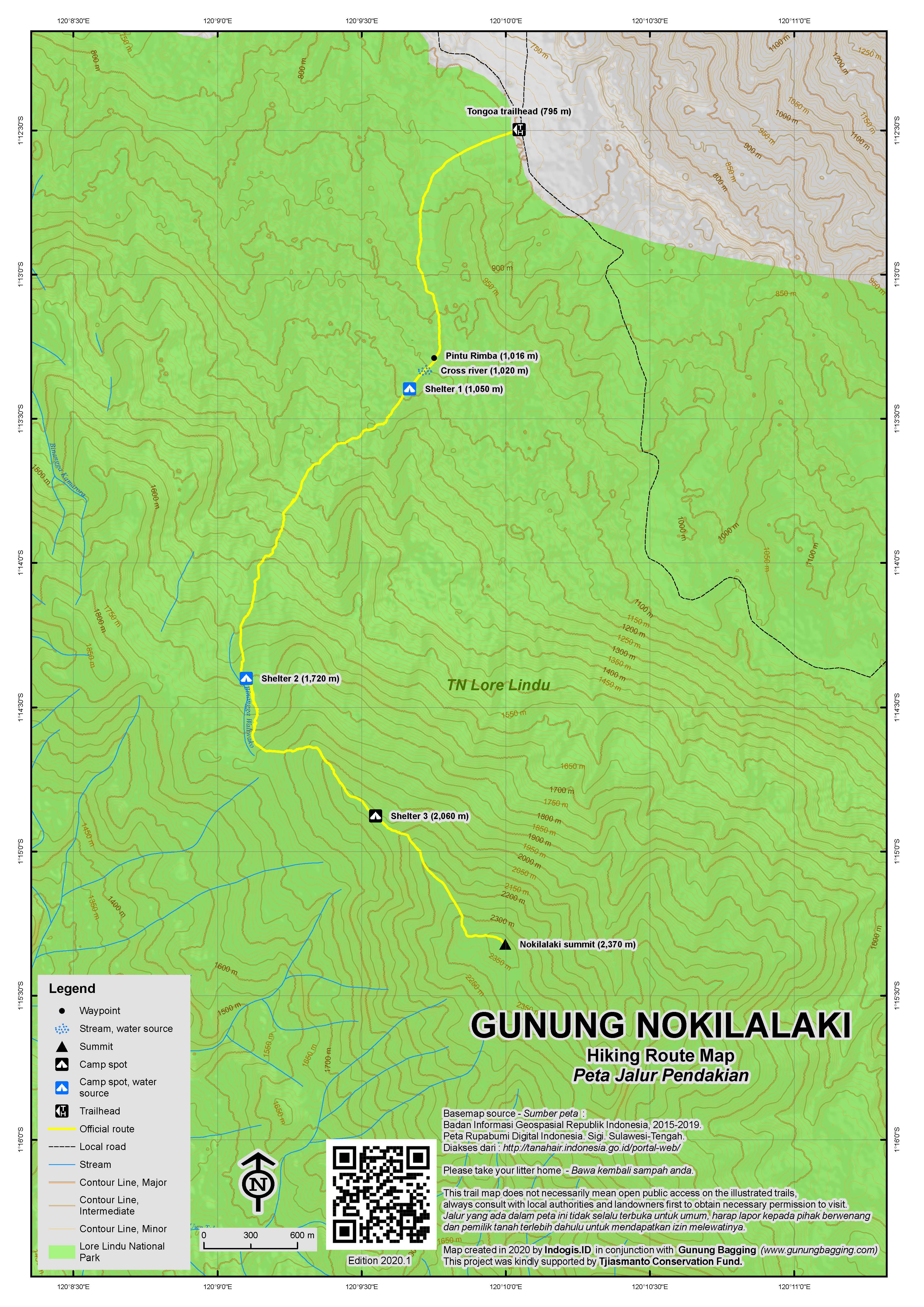
Gunung Nokilalaki is a very attractive-looking forest peak in Lore Lindu National Park and has the most straightforward trail in Central Sulawesi.Whereas many of Sulawesi’s mountains are arduous affairs, Nokilalaki is a delight, with clear signs at Shelter/Pos 1, 2 and 3, and a large cement triangulation pillar at the summit. This is a great mountain for bird-watchers but those looking for panoramas of distant mountains may be disappointed as the views are pretty limited. Nokilalaki makes a good warm-up hike for something much tougher, or a great one or two-day hike in its own right. If you started hiking at 6am you coud just about complete the hike in a single day (12 hours or so) but most people like to spend at least one night camping in the forest.
The main trail up Nokilalaki starts beyond the attractive rice paddies of Palolo and Desa Tongoa at a warung (795m) on the right side of the road. It takes about 2 hours to reach here by car or motorbike from Palu, and though the Nokilalaki trailhead sign is severely faded (in 2017) most locals will be able to point you in the right direction.
Follow the stony track up through cocoa plantations and then veer to the right after 45 minutes and enter forest near a river. Just ten minutes more and you will be at the lovely Shelter 1 (1,050m) which consists of four basic wooden shelters next to a very pleasant river. Each shelter can accommodate one tent and there is some additional space available to camp on the ground near the river itself. The temperature here is lovely and this is the ideal place to camp if you made a late start from Palu. Listen out for hornbills.
Beyond Shelter 1, the trail gets much steeper, but is very easy to follow as it leads you higher and higher up the mountain. Fit hikers should be at Shelter 2 (1,720m) in 2 hours from Shelter 1. Alas, there are no actual shelter structures at Shelter 2, but plenty of space for tents and a stream for water just 2 minutes on the right. Watch out for bees here – best keep your shirt tucked into your trousers to avoid them following the smell of your sweat a little too closely!
Beyond Shelter 2, the trail continues steeply up the mountain. After about one hour, you will be on a fairly narrow, airy forest ridge, with glimpses of Lore Lindu lake down to the right and obscure forested hills to the left. This is almost the only opportunity for panoramic photos. After another 15 minutes you will be at Shelter 3 (2,060m), which again has no actual shelters but is a tiny spot on the ridge with enough space for maximum two small tents.
From Shelter 3 to the summit takes another hour. There are some views to the fields of Desa Palolo on the left about halfway between Shelter 3 and the summit. Most sources, including summit signs, suggest that Nokilalaki is 2,355m high. However, based on GPS data, SRTM data, and one of the more offocial signs, we think the real height is closer to around 2,370m.
There is a much less popular trail beyond the summit pillar leading all the way down to Lore Lindu lake, but apparently this takes 3 days or so. The adventurous might consider doing a traverse, but those with limited time can be back down at the Tongoa/Palolo trailhead in 5 hours or so.
Bagging information by Dan Quinn (January 2018)
Trail Map
For a high quality PDF version of this and other trail maps, please download from our Trail Maps page.
Practicalities
- Getting there: It takes about 2 hours to reach from Palu where there is an airport.
- Guides and GPS Tracks: Want a PDF version for your phone? Looking for a guide? Need GPS tracks and waypoints? Gunung Nokilalaki information pack can be downloaded here.
- Trip planning assistance: Would you like Gunung Bagging to personally help you in arranging your whole trip? Please contact us here.
- Permits: There is no official entry booth and in reality very few local hikers pay to enter Lore Lindu National Park. As usual, foreigners are supposed to be charged over 10 times the local price (foreigner price Rp150,000 per day in 2017) just for being there, but there is no booth at the main trailhead (in 2017).
- Water sources: Available at Shelter 1 and Shelter 2.
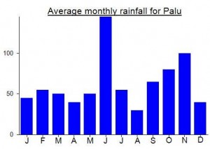
Local Average Monthly Rainfall (mm):
Location
Click on the blue arrow ![]() (top right) to see your current location on the map
(top right) to see your current location on the map
After success on the reasonably tough Bulu Nti, Nokilalaki was a lovely. relatively simple follow-up. That we took 3 days over it meant that my feet could have a break on Day 1 (which was just 45min from trailhead to Shelter 1). Day 2 was up to the peak with its huge presumably Dutch trig pillar (would love to do some research on the history and process of constructing these many pillars across the archipelago) and then camping at the tiny Shelter 3 (which the locals found very cold being at over 2,000m). On Day 3 we were back down by 11am at the trailhead warung. Thus you can easily accomplish this hike in two days, or even 1 if you have no interest in camping and can start the trek at 6am or so.
Several other groups on this trail over the holidays and it is obvious why…. it’s easy but not popular enough to be spoiled with too much litter. Strong families could do this one. There are a lot of sweat bees – I got stung on the back at Pos 2 when one got into my shirt. A little painful and a swelling but no nausea.
One thing to bear in mind, however, is the terrorist threat in the province which is reduced from previous years but still not as low as other Sulawesi provinces. Nokilalaki was closed for a while a couple of years ago as the authorities searched for Santoso and his men. Well, the leader is no more, and the group is apparently down to less than 10, but the mountain areas they live and train in are allegedly those to the west of Poso, stretching as far west as Gunung Rore Kautimbu / Torenali which lies further southeast from Nokilalaki and remains officially closed (at least overnight camping is very much advised against). The last thing you want it to be asked for a selfie by some guy brandishing an AK47. The key is to check local information (such as with Taman Nasional Lore Lindu) at the time of your planned hike, but the group seems in decline thankfully and Nokilalaki is a fair bit further west than the main areas to absolutely avoid. It’s a terrible shame as the province has some brilliant peaks with little information, but large areas remain rather dangerous to go trekking in.
Masetro Pizza was open once again upon arrival back in Palu so I had a great afternoon there before getting reading for my trip to the Togean islands and Gunung Colo.
Actually no special basecamp, only warung before hiking route. From main road (Desa Tongoa), it will take around 1km walking (1 hour) to 1st shelter. There is small river just flow next to 1st shelter. Continuing our hiking, next shelter (2nd shelter) can be reached in 1.5 hour (fast walking) and could be 2.5 hour (relax walking). The route is very exhausting since it continuously ascend without any “flat bonus”. The route consists of mud and root and always wet. Arriving at 2nd shelter, there is big enough field for 5-6 tents. There is small river near this shelter. From 2nd shelter to 3rd shelter will need 2-3 hours walking. Same condition and very exhausting due to unstopped ascend. Shelter 3rd no water and very small. It can only be used for 1 tent. Suggested to go directly to peak if still possible. From 3rd shelter to peak will take you around 1-1.5 hour walking. The route is less ascend than before. You can camp near the summit and also the summit area since they are quite flat. There is place for more than 10 tents near summit and at summit. The summit itself has one concrete small tower. The condition of summit is very damp and wet. You can not see the scenery freely since the summit is very forested.