
Facts
- Elevation: 435 m (1,427 ft)
- Prominence: 435 m
- Peak category:
 Spesial
 - Province:
 Sulawesi Tengah (Central Sulawesi)
 - Island: Una-una
- Coordinates: -0.1778, 121.6111
- Rating:


 (3 votes) Add your rating
 Loading...
 - Eruptions: 1898-1900, 1938, 1983
Photos


Bagging It!
Gunung Colo on Pulau Una-una is Central Sulawesi’s only active volcano. It is perhaps the most isolated of the Togean Islands group in the Gulf of Tomini, but access is fairly easy given how popular the islands are with divers. The volcano has only erupted three times in recent history, but the most recent one in 1983 devastated the island, permanently altered the shape of its rivers, and forced all residents to evacuate. If using a motorbike (or a guide with one) Gunung Colo is an easy half-day excursion from Nino’s Homestay or Sanctum Resort on the same island.
Una-una itself is about 10 kilometres across and the main volcanic activity and highest points of the island are fairly central. To reach the island, most travellers first get to Wakai on a slow public ferry from Ampana or Gorontalo or speedboat from Ampana (much faster – just 90 minutes). If you are staying at Sanctum divers resort then you will normally be taken across directly to Una-una from Wakai (Rp800,000 one way for a boat with two motors, taking just 90 minutes, arranged in advance). Otherwise, you should be able to charter a slower boat in Wakai for around Rp500,000-Rp600,000 one way (just under 3 hours using just one motor).
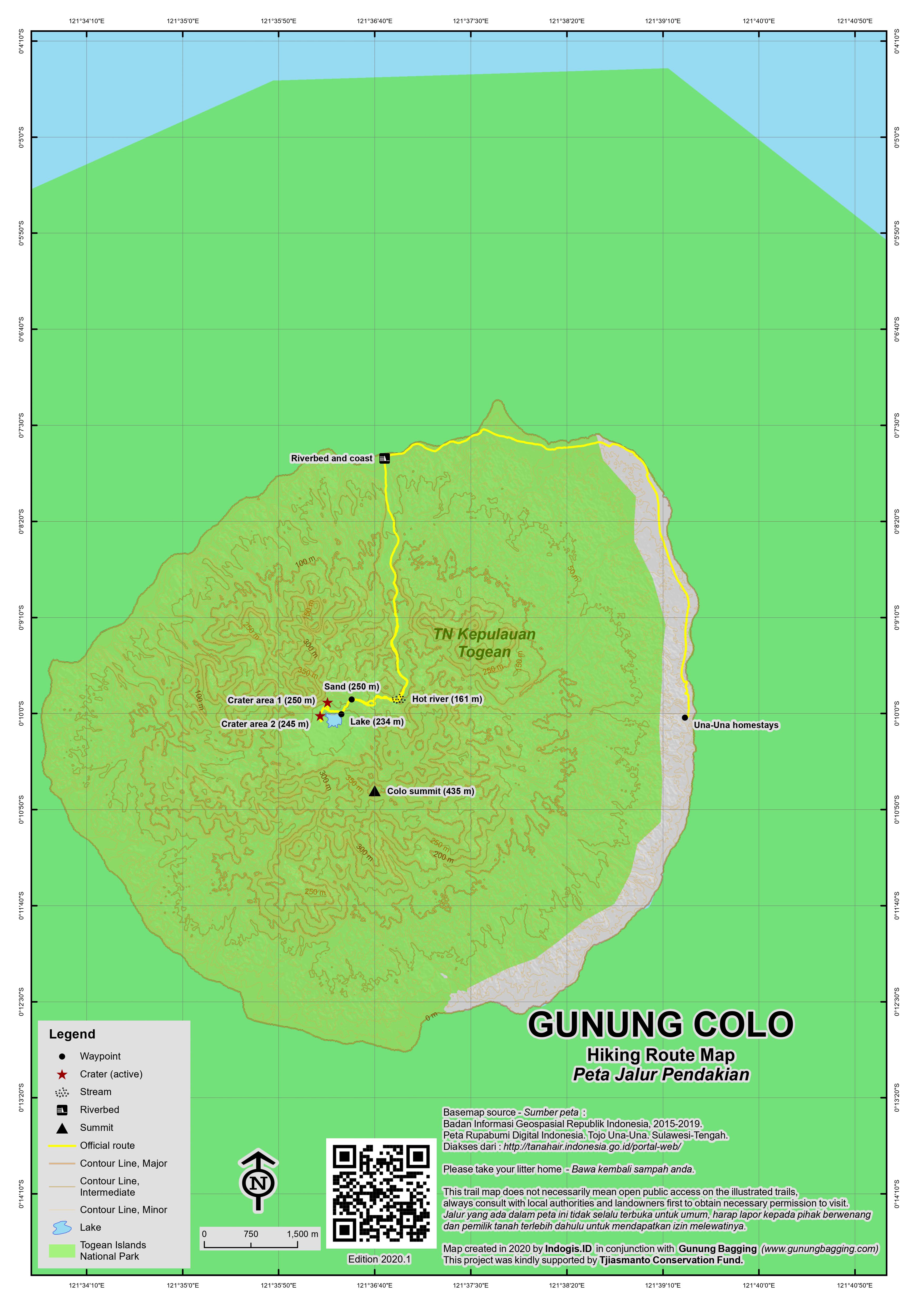
The divers resort, homestays and village on Una-una are on the east of the island. The volcano can be approached from this side via dense jungle (supposedly 3 hours each way), but it is becoming more common to head up to the north by motorbike (anti-clockwise) and up a wide, dry, sandy river (one hour) as far as the motorbike can realistically go (usually only a kilometre or two). From here it is only 90 minutes or so to the craters, so if you set off at 7am you can easily be back at your accommodation for lunch.
The usual spot that motorbikes are left at is at about 80 metres above sea level. The scenery is already rather fascinating, as it is obvious that something huge must have occurred to create such an unnecessarily wide river bed for such a tiny river. Indeed, it would appear that this riverbed was greatly widened by pyroclastic flows in 1983 when the volcano last erupted.
Your guide will probably point out that the little river here is no ordinary river but flowing with hot water (161m). From here, follow the riverbed as it slowly leads up into the interior of the island! After half an hour or so you will reach a fork in the river – cold water flows down from the left and hot water flows down from the right. Take a right here into denser jungle and a short, steep, roped section. The path is quite clear beyond the roped section, as it leads through dense foliage to a dry area of volcanic sand (250m). It should have taken you about one hour to reach this point. You may be able to smell sulphur. The trail leads down a little to the left to an unexpectedly large lake (234m). Look out for herons and kingfishers here waiting to catch the many fish that inhabit this lake.
From the edge of the lake you will see beyond to the left the densely forested highest tops of the island that apparently nobody visits and there is no trail to. Over to the right, on the far side of the lake, you will probably notice some volcanic emissions rising above the trees. It takes just 5 or 10 minutes to walk round to the first of two separate sandy craters. The activity in the first one is at the edge, at the bottom of a rocky cliff. The second one, another couple of minutes walk, has emissions in numerous places and can get quite noisy, like a fry pan that has been left on the hob for too long!
Some internet sources give a height of 507m for the volcano (or rather the highest peak of the island 1.3km from the craters). It could certainly be possible that Colo was once 507m high and a huge eruption brought it down to the approximately 435 metres elevation that the island is now, but given US Army maps from the 1950s give a spot height of 401m (an underestimate perhaps), I am inclined to think that either the 507m height is simply a large error, or that perhaps the volcano looked very different prior to the 1938 eruption during which it lost over 50 metres. Either way, it certainly wasn’t the 1983 eruption that was responsible for the markedly different published figures.
According to both Google Maps and 1950s US Army map data, the highest point in the Togean islands is on Pulau Togean/Togian itself at around 542m. Like the higher slopes of Pulau Una-una, this is likely to be covered in dense vegetation and with no trail.
From the Colo crater areas it is just over one hour back down to the bike, and then another 45 minutes by bike back round to Una-una village and the main accommodation.
Bagging information by Dan Quinn (January 2018).
Trail Map
For a high quality PDF version of this and other trail maps, please download from our Trail Maps page.
Practicalities
- Getting there: Lots of tourists visit the Togean islands for diving. There are boats from both Ampana in Central Sulawesi and Gorontalo. The easiet way to reach the Togean islands is to fly with Wings from Palu to Ampana’s Tanjung Api airport (daily in 2017, 09.20-10.10), take a bentor to Ampana pier and book a fast ferry (usually 2 a day – Hercules at 9am and Manakarra at 12noon or 1pm) for around Rp130,000 to make the 90-minute crossing to Wakai. Then charter a boat to Pulau Una-una or arrange in advance via local accommodation. There is actually an early morning public boat between Wakai and Una-una and back again (Rp30,000 each way in 2017) but this only makes 3 trips in each direction per week (check with Sanctum or your homestay for the latest timetable) so may not fit in with your schedule.
- Guides and GPS Tracks: Want a PDF version for your phone? Looking for a guide? Need GPS tracks and waypoints? Gunung Colo information pack can be downloaded here.
- Permits: Not required.
- Water sources: Carry enough with you (one 1.5 litre bottle per person should be sufficient).
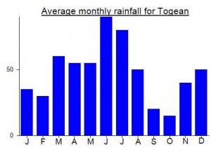
Local Average Monthly Rainfall (mm):
Location
Click on the blue arrow ![]() (top right) to see your current location on the map
(top right) to see your current location on the map
The new airport at Ampana with daily flights to/from Palu has made things a lot easier with regards to getting out to the Togean islands. I woke up in Palu and was on Pulau Una-una by 4pm the same day. Just Rp30,000 for a bentor from the airport to the pier, and then the lunchtime fast boat which is cramped and has no toilet but is indeed fast. It usually calls at a few other places before the main destination of Wakai, incuding Bomba divers etc etc. The slower boat (Rp65,000) takes around 4 or 5 hours. Most local folk in Ampana are friendly and helpful and should be able to give you contact numbers or updated information.
From Wakai to Una-una, the public boat leaves around 7 or 8 am on Sunday, Tuesday and Thursday and travels in the opposite direction on Saturday, Monday and Wednesday. There is no public boat from Wakai to Una-una on Fridays. Generally, if there are a few of you, you might aswell charter a boat over. I was lucky as there were some divers going over to Una-una on the Sanctum boat waiting for them at Wakai so I paid a quarter of that price (800,000 for the boat meaning Rp200,000 per person) and they dropped me off right at the front of Nino’s Homestay. According to Andri of Sanctum Resort, most travellers still come from the north at Gorontalo (despite the longer distance), but perhaps this will change over time.
The Una-una beaches may be a little less beautiful than those at the resorts on Pulau Togean and Pulau Batudaka and surrounding islands (the main group) but the remote and friendly Una-una atmosphere is fabulous. Nino’s is a great place to stay…. Rp150,000 per night including 3 meals a day, and vegetarians can be catered for pretty easily as long as you tell them. Dolphins playing just ten or twenty meters out in front of the cottages at first light. You can also walk to the Sanctum resort in about 15 minutes where there are likely to be other foreigners sitting around if you feel like having a chat. Best bring any special supplies or food favourites to the islands with you are everything has to be shipped in meaning less choices and higher prices. Beer is available to non-residents at Sanctum but is Rp40,000 per small can.
My guide for Colo was Pak Aziz (Asis?) from the house behind the Nino Homestay. At Rp200,000 for the half-day trip including the motorbike ride for just under an hour each way I think this is excellent value. Most folk out this way are ready to help for a very reasonable price.
Phone reception is very poor on Una-una (fine for many networks in Wakai though) so try to make arrangements for being collected again in advance. I tried to contact a chap in Wakai called Pak Lapipi via SMS (082347134553). He can arrange basic slow boat transportation to and from Una-una at around Rp600,000 per trip (expensive for one person, but fine if a group). However, having got no response, I thought it best to ask locally in Una-una. A boatman a couple of houses down from Nino’s agreed to Rp500,000 so I agreed to that – good value for a 2hr40min crossing. Amazingly, when the morning came, Pak Lapipi had sent someone over to collect me (!) so I was worried there were 2 boatmen waiting for me. However, Lapipi’s friend had already smoothed things over with the local boatman (most of the islanders know each other very well indeed) so there was no problem and I just paid the Rp500,000 as agreed.
I got what may have been the last ticket in the fast boat back to Ampana on New Year’s Eve so ask your resort to reserve ahead if possible. There was a poster saying you will be able to book these tickets online soon but somehow I can’t see this turning into reality for quite a while!
One thing to bear in mind when on the boat back to Ampana is that there are two different harbours a couple of kilometres apart! We got dropped off at Pelabuhan Belanda (Dutch Harbour) and had to clamber through numerous other vessels trying to find a way onto dry land!