
Facts
- Elevation: 1,275 m (4,183 ft)
- Prominence: 743 m
- Peak category:
 Spesial
 - Province:
 Nusa Tenggara Timur
 - Island: Flores
- Coordinates: -8.6152, 119.9763
- Rating:

 (5 votes) Add your rating
 Loading...
 - Other names: Golo Beliling
Photos


Bagging It!
Gunung Mbeliling is the westernmost significant mountain on the island of Flores. Probably because of its proximity to Labuan Bajo – where many tourists stay before or after visiting Komodo island – a Mbeliling hike has in recent years become part of the ecotourism options available to visitors to West Flores and has featured prominently in tourism literature for the area.
It is actually located just a few kilometres to the north of the ancient 3-kilometre wide Wai Sano caldera which contains Sano Nggoang crater lake, the largest in Flores. There are apparently two solfataras on the south-eastern shore of the lake. Gunung Mbeliling is not an active volcano but rather a cool and shady forest ridge popular with birdwatchers.
Back in 2013, there were promotional signs for Mbeliling by the side of the road and at the airport and, during the high season, foreign tourists climbed it on a fairly regular basis from the village of Roe, which is one hour from Labuan Bajo.
Roe is at about 600 metres above sea level, so it’s not much of a significant climb to the top of Mbeliling for those who are accustomed to hiking in Indonesia. The recommended trek includes one night camping at or near the top and a visit the following day to Cunca Rami waterfall. If you have the time, the sunset and sunrise are very nice indeed, but the hike can easily be done in a single day trip or even as a half-day outing if you prefer.
Fast forward to 2020, and Roe is no longer the starting point of choice, although the hike remains possible from there. Now, Dusun Cecer, Liang Ndara is the recommended trailhead, with friendly and informative guides who are also happy to show you around the plantations and tell you about the unique culture of the area. There is even a homestay if you fancy a simple night in a village in the hills.
Dusun Cecer has another advantage over Roe which is that it is slightly closer to Labuan Bajo, requiring just 40 minutes to get there. At 620 metres above sea level, the hamlet has great views to the coast and apparently you can even sometimes see Sangeang Api volcano island in the distance in clear weather.
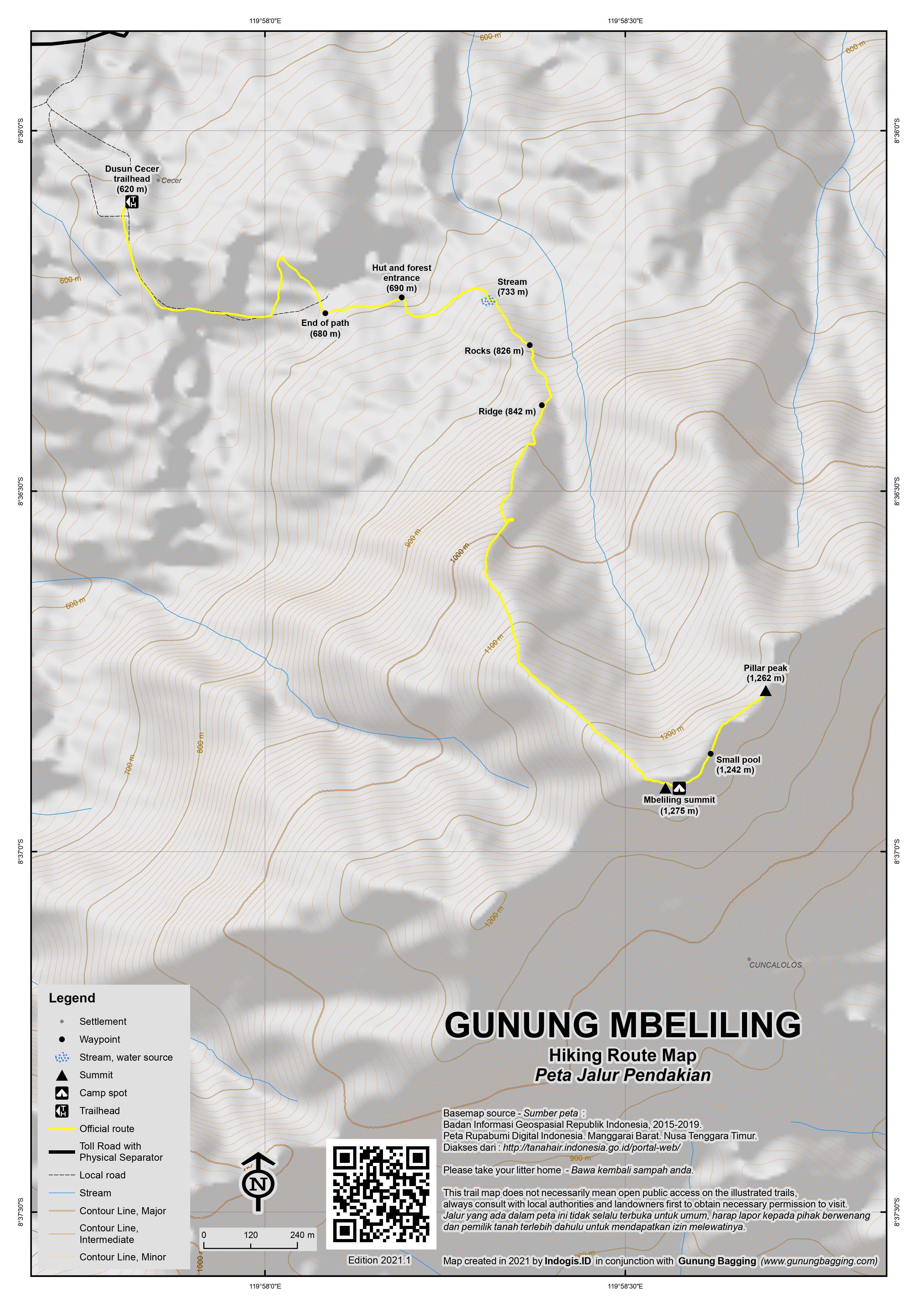
From the village, the paved track leads through pineapple and coffee plantations before reaching a wooden hut at the edge of the forest (690m). Soon after entering the forest you will see a black water pipe and shortly afterwards a narrow stream (733m). This is the only reliable water source on the trail but be careful as you cross it as the gully is quite deep. Also watch out for leeches are they are quite common in the Mbeliling rainforest.
The trail at this point is quite vague and thus a guide is pretty essential. The terrain becomes steeper with big boulders (826m) before a narrow ridge (842m) is reached with a pleasant small rock to rest on. From here the trail follows the ridge roughly southwards and at an elevation of around 900 metres there are some great views back down to the village and further away to the coast and the islands off the coast of western Flores.
The trail continues to follow the forest ridge until the vegetation changes and becomes more dense and then suddenly you find yourself at a grassy, open area with no signs but great views in clear weather. To the west you can look towards Labuan Bajo, the airport runway, and the Komodo islands. It should have taken fit hikers no more than 2 or 2.5 hours to get here from Dusun Cecer.
The Bakosurtanal map labels the peak “Golo Beliling” with an elevation of 1,266m, with a second 1,251m spot height for a point just a couple of hundred metres to the north-east. Based on GPS readings, these figures are slightly under the true elevation. First of all, this grassy, open area is the true summit with an approximate elevation of around 1,275m. It is also the best place for camping to enjoy the sunset or sunrise views if you have opted for a two-day trek.
The view south is also especially good, with Sano Nggoang lake often partially visible and a significant peak behind it. Indeed, the highest peak in this far western end of Flores is actually about ten kilometres south of Gunung Mbeliling and labelled Poco Sesok (1,335m) on the map, supposedly also known as Gunung Cerak, which is just to the south-east of Sano Nggoang lake. There is virtually no information on Poco Sesok available online, so it is unlikely there is a trail to the summit at present. However it has around 925 metres of topographic prominence so is likely to be a pretty good mountain to explore in its own right.
What of the second peak on the Bakosurtanal map? Well, if you continue to follow the trail from the true summit of Gunung Mbeliling as it drops down via a small muddy pool before ascending again, you will in just 15 minutes be at the slightly lower north-eastern peak. According to GPS this peak is around 1,262m above sea level.
This lesser peak is well worth a visit as the old Dutch-era triangulation pillar is here, labelled P27. Apparently views to the east at sunrise are great from here. Beyond this secondary peak, a currently less well-used trail continues down to Roe.
Back to the true summit and camping spot takes a similar amount of time and after enjoying a bit of cooler air you can be back down in Dusun Cecer in just 2 hours or so, meaning a round trip of around 5-6 hours so roughly 7-8 hours in total including travel time from and back to Labuan Bajo.
Bagging information by Dan Quinn, October 2020
Trail Map
For a high quality PDF version of this and other trail maps, please download from our Trail Maps page.
Practicalities
- Getting there: Mbeliling can be climbed from Dusun Cecer and Roe which are both on or near the Trans-Flores road between Labuan Bajo and Ruteng. From Labuan Bajo, allow 40 minutes to Dusun Cecer, or about one hour to Roe. Labuan Bajo has plenty of flights, mainly to Denpasar plus one or two per day to Jakarta and Surabaya.
- Guides and GPS Tracks: Want a PDF version for your phone? Looking for a guide? Need GPS tracks and waypoints? Gunung Mbeliling information pack can be downloaded here.
- Permits: Not required but take a copy of your passport photo page just incase and register with the local village head.
- Water sources: There is a small stream at 733m on the trail from Dusun Cecer.
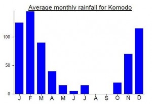
Local Average Monthly Rainfall (mm):
Location
Click on the blue arrow ![]() (top right) to see your current location on the map
(top right) to see your current location on the map
Origins and Meaning
‘A place to seek protection’ from Mbau (place) and iling (shady).
I remember back in 2013 being somewhat frustrated and annoyed at not bagging Mbeliling, the last peak on my trip list. In recent months I started looking at it again, but after contacting folk in Roe, even connected to the earlier promotional campaigns to lure tourists away from the coast and up into the hills, it felt as though the interest in Mbeliling had dwindled somewhat. Nobody seemed all that interested in naming a price for a day-hike from Roe. Was it due to the whole Covid thing, and me being a foreigner? Not sure.
Anyway, after looking around more online it appeared that Cecer, Liaang Ndara was at least as good a starting point for Mbeliling if not even better. And indeed it is! Brilliant folk and very welcoming to tourists. One of the best guides I have ever had. They even have a dual-language information board about tourism and local cultural information, and you can buy local coffee and other souvenirs. And there’s a simple homestay too, with a great view out to the islands. I was really impressed. They even gave me a breakfast before the hike, as it was still quite early.
I can see why the mountain is popular with birdwatchers… this is good quality forest once you get into it and the local community knows that and seems determined to encourage visitors to the area to enjoy it. It’s certainly a real change from the roasting hot coastline – a good place to cool down a bit.
Alas the weather wasn’t perfect, as the summit was draped in a blanket of cloud, but intermittent views to the coast were very pleasant. No view of the lake to the south this time however. Based on GPS, the pillar peak 15 minutes beyond the camp spot peak is around 10-15 metres lower. This would be the first peak visited if hiking up from Roe. A traverse would be interesting.
I was just about back in Labuan Bajo in time for lunch! 100% recommended for those with a bit of extra time before or after a Komodo trip.
This was to be my final hike of the NTT trip. I arranged with Pak Alfons of Roe directly in advance. Unfortunately he initially wanted a ridiculous Rp600,000 for what is a dayhike up the hill at the back of his village. Alas, due to the huge tourism overflow from Bali to Komodo during June July August, the prices are somewhat preposterous and you should avoid paying the ‘foreign price’ as much as you can.
Why international agencies have encouraged this overcharging is an interesting question. According to Lonely Planet, the whole Mbeliling thing is an attempt to get tourist money into the local villages as opposed to it all being spent in Labuanbajo and Komodo.
I managed to bargain him down to Rp300,000 for the dayhike, which is the absolute maximum anyone should pay for a guide for a dayhike in Indonesia. If such a guide made 300,000 per day, the monthly salary would be a whopping Rp9,000,000 – more than most earn, even really skilled and experienced professional staff in Jakarta. So bear it in mind and fight against the overcharging, particularly of foreigners.
In actual fact I would prefer to climb this simple mountain alone. I wonder if this would cause a problem with the locals. After all, all they really need to do is stick up a sign or two and you wouldn’t need a guide at all. The two-day hiking option is definitely trying to milk it a bit – far better would be to climb at night in time for sunrise. It can’t be more than 3 hours to the top from Roe.
Anyway, after agreeing on a price, Pak Alfons also found one of his sons to pick me up from Labuanbajo on his motorbike at 6.30am prompt. It would costs Rp150,000 for the return journey. Be ready before 6.30am, he said.
Well, I was sat outside Chez Felix at 6.15, doing up my boot laces, ready for the final hike of the trip. 6.30 came and went. At 7 I went and had a coffee and admired the views over the bay from the Chez Felix dining area. Finally, Alfons texts to say his son was stung by a bee last night so I would have to find my own way up there.
With this being a very hot part of Indonesia I had wanted to set off hiking as early as possible. Now, even if I could haggle and debate with ojek guys in Labuanbajo it was going to be at least 8.30 before we got started hiking. And I was thoroughly knackered and quite keen to sample some more Italian food on the waterfront, after so many days of rice and basic vegetables.
More than that, I was understandably annoyed that they hadn’t told me in advance. If I had been informed the night before I would have found a different ojek. But, as it was, they kept me waiting around for a motorbike that was not on its way at all. So I told Alfons to forget it. I would climb another time. If he didn’t possess the manners to tell me in advance then I really couldn’t be bothered. Why spend ‘tourist money’ in the villages if they can’t even arrange basic transport to/from the mountain that you are paying handsomely for?
So Mbeliling will have to wait for another time. Labuanbajo was great foodwise, but I must say I have never seen so many miserable looking foreigners. Not the friendliest of places – enough foreigners there that instead of greeting each other, they simply try to avoid eye contact, for the most part. Much better to visit outside of the high season, I would say.
So a final day of eating pizza and pasta before heading back to Jakarta it was.