
Facts
- Elevation: 1,581 m (5,187 ft)
- Prominence: 701 m
- Peak category:
 Spesial
 - Region:
 Sabah
Sabah - Division: Bahagian Pantai Barat
- Coordinates: 5.7760, 116.9487
- Rating:

 (2 votes) Add your rating
 Loading...
Photos


Bagging It!
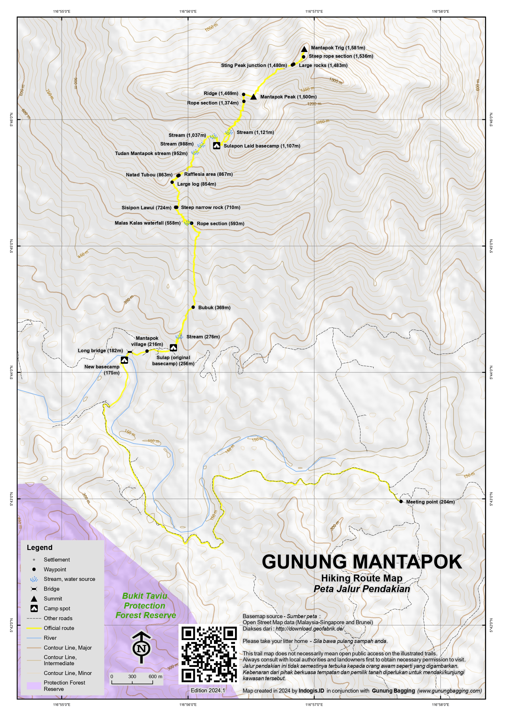
Gunung Mantapok is one of Sabah’s finest and most memorable mountain treks. It is located very close to a higher peak, Gunung Monkobo, which does not yet have a trail. The Mantapok trek usually takes 2 days and 1 night, though it is technically possible to do it in a single day if you can arrange to start just after midnight.
The meeting point (204m) in Kampung Miruru for Mantapok Nature, the local group who arrange guides and permits here, is well signposted on the left side of the road. From here you will take a 4WD approximately 9 kilometres along a bumpy track which unfortunately does not gain any elevation and drops you off at a large sign (175m) for Mantapok Nature near a large shelter, private dwelling, and, most excitingly of all, a 200 metre long bridge across the Sungai Labuk river.
To get started on the trek itself you need to cross that bridge over the river and it is quite a nerve-wracking experience! Just look forward and concentrate on making progress! Local people use this bridge on a daily basis but to others it may appear like something out of an Indiana Jones film.
Once on the other side, follow the path up to Mantapok village (206m) and Sulap (256m) which is a wooden building which was the original basecamp. It is no longer used by hikers but is a key point on the trail. There is actually an information board with distances to numerous points of interest on the trail ahead.
The trail crosses a stream (276m) before leading up to Bubuk (369m). The trail then continues to ascend up the hillside before a short and steep descent (593m) with a rope for assistance down to the very scenic Malas Kalas waterfall (558m). This is a perfect place to have a short break.
After the waterfall, the trail is very steep indeed and some care is required here. After a narrow rock section (710m) is negotiated, another rest spot is reached, known as Sisipon Lawui (724m). After this, Natad Tubou (863m) is the next point on the trail and just before the section where you are most likely to spot Rafflesia.
Next up is Tudan Mantapok (952m) which features a pleasant stream. Another couple of streams are then crossed (at 988m and 1,037m) before reaching Sulapon Laid (1,107m) which is known as ‘Basecamp 2′ is a large wooden structure suitable for groups of hikers to use. This makes it unnecessary to cary a tent up here with you. There is even a small cooking area, complete with cutlery and gas, a toilet located a short walk away, and a separate small shelter for local guides. The elevation means that the temperature here is incredibly pleasant, neither too hot nor chilly. You may also get a partial view between the trees from just beyond the guides’ shelter. It should have taken around 4-5 hours to reach here.
If you started your hike early in the morning you will most likely have the afternoon to relax and enjoy here before making a very early start towards the summit the following morning.
On Day 2, the trail does not start steeply, crossing a stream (1,121m) first. Once you do reach the steeper parts of the trail you will be at a rope section (1,374m) and then what feels like the ridge (1,469m). From here it is a short push to what is known as Mantapok Peak (around 1,500m). This is not the highest part of the mountain but in clear weather there are great views to Kinabalu on one side and down to the long bridge at the trailhead on the other side.
From Mantapok Peak, it is still a bit of a distance to the other two peaks, Sting and Trig. The mossy forest terrain makes fast progress nearly impossible and you need to drop down a little first before ascending again to the base of the cliffs of Sting Peak where there is a junction (1,480m) where hikers heading for Sting would turn left off the main trail. In 2023, Sting Peak is closed due to renovation work being required on the ropes and ladders which provide access up what looks like near-vertical terrain!
The trail continues on to Trig Peak by skirting round the base of large rocks (1,483m). There is a rope section (1,536m) where care is required and then eventually you will emerge on top of one of the precarious boulders which mark the highest point of Mantapok Trig Peak (1,581m). Because of the size of the boulders and the inability of tall vegetation to grow on the top of them the view is superb up here. This place is named Trig for a very good reason, as there are actually two trigs, with both a cylindrical cement pillar and the basic triangular metal frame of what Malaysians from Semenanjung Malaysia (West Malaysia) call a ‘beirut’. The panorama here includes Tambuyukon, Kinabalu, Sinsing and Trusmadi. In effect, all the highest peaks of Sabah. There are also countless lesser peaks on show, many of which are obscure.
The route back down is the same as the ascent, returning to Mantapok Peak to admire the view to Kinabalu and down to the Labuk river, then back to the wooden shelter for a drink and snack before descending and crossing the bridge a second time. Your 4WD should be waiting for you there.
Bagging report by Dan Quinn (August 2023)
Trail Map
For a high quality PDF version of this and other trail maps, please download from our Trail Maps page.
Practicalities
- Getting there: For Malaysian domestic flights and flights within Southeast Asia, for example to Kota Kinabalu or Kuching, we recommend Baolau. Sandakan is the closest city with a major airport. From there it is around 3 hours to the meeting point in Miruru which is not far from the main Ranau-Telupid road. Ideally you need private transport.
- Guides and GPS Tracks: Want a PDF version for your phone? Looking for a guide? Need GPS tracks and waypoints? Gunung Mantapok information pack can be downloaded here.
- Permits: Arranged by Mantapok Nature.
- Water sources: Plenty available as far as Sulapon Laid, also known as Basecamp 2 and where most hikers will spend the night.
- Accommodation: Try the Booking.com map above or use this link to search for suitable hotels, homestays, resorts and apartments for your trip.
- We recommend Safety Wing as travel insurance for overseas travellers and tourists hiking up to elevations not exceeding 4500 metres.
Location
Click on the blue arrow ![]() (top right) to see your current location on the map
(top right) to see your current location on the map
After a night near Ranau I was ready at 4am to drive round to Kampung Miruru where the meeting point is, at the house of the Mantapok Nature manager Mr Yukili for a 6am start as planned. There is, or used to be, accommodation nearby at Rumantai Guest House but it was closed in summer 2023. Worth a try in future to see if they have reopened.
The gravelly road down to Miruru from the main Ranau-Sandakan road is a bit rough but not too steep, you just need to drive slowly. The 4WD was waiting so we set off on the very rough track to Sungai Labuk (Labuk River) which is where the trail starts. It is supposed to be about 9km from Miruru and takes 30 minutes or so.
I was then given a waiver form to sign by a girl from the house by the river. A waiver just before crossing what appears to most ‘city’ people to be a rather rickety bridge, and one that stretches 200 metres across the Sungai Labuk. I just looked ahead, avoided looking down, and made my way across. It was quite a relief to get to the other side, but of course you have to do the same thing on your return if you want to go home!
Then through the kampung and past the original Basecamp 1 with a useful sign re checkpoints on the trail, and onward the via gorgeous waterfall and up to Basecamp 2 at 1100m ish, large enough for 30 people, built in 2016, the same kind of setup as Gunung Sinsing with gas, cutlery, piped water, a toilet block and so on. No need for a tent. About 3hr40 to here going slowly. The plan was a long relax with Alex the excellent guide and start the hike to Mantapok peak and trig – apparently the highest – at 2am from here. Lots of hornbills and very young Rafflesia near Natad Tubou.
It only took us 1hr20 to Mantapok peak, and it was obviously still dark. The figure given on the Mantapok Nature hiking certificate for Mantapok Peak is 1,481m but my GPS read 1,493m and 1,520m on the way back down, so I think more likely to be in the region of 1,500m. We didn’t wait long there, as no view at this time in the morning. It took us another 1hr40 to Mantapok Trig, moving slowly through mossy terrain and a small number of roped sections. There was some light rain but by the time we reached the trig pillar on the summit rocks and the remains of the metal Beirut it had stopped raining and the view was obviously going to be excellent in all directions as the light grew. The 1,581m was matched by my GPS.
The third peak, lying between Mantapok Peak and Mantapok Trig, called Sting Peak is currently closed due to repair work on the final ascent, which is basically near-vertical up ladders and rope. The Mantapok Nature hiking certificate states that Sting Peak is 1,581m too. From the trig is is clear that there are some trees that are a tiny bit higher than the trig, but it is impossible to tell if Sting Peak is higher without some better evidence. At present, i would say probably not, probably a handful of metres lower. But I am open to be told I’m wrong in my assumption.
The view to the higher Monkobo, plus Kinabalu, Tambuyukon, Trusmadi, Sinsing, and so on, means that this is one of the finest views in all of Sabah and we spent a while enjoying it before descending.
It only took 1hr back to Mantapok Peak and the view behind the wooden sign to Kinabalu was just beautiful. Also the view down to the Sungai Labuk river. This is also a great spot for a couple of fdifferent species of pitcher plant. And we were back down to Basecamp 2 in just 55 more minutes.
After packing up and having a coffee it took just 2 hours back down, going fast, to the bridge and the wooden building by the river which is the new ‘Basecamp 1’. I asked Alex if many hikers had been too scared to cross the bridge at first, and he confirmed that plenty had been nervous and even screamed! Certainly no more than 5 people should be crossing it at once for weight reasons.
It cost me RM750 total including RM150 for the 4WD return. A bit expensive so go with friends if you possibly can. Another good eco tourism initiative that deserves to be supported.
This was my last Sabah hike, and a great one to finish with, probably the best views I had. I then drove to Sepilok for a night at a resort on the edge of the forest and very popular animal sanctuaries. I actually had the entire dorm to myself as most folk who stay here prefer a private family chalet or similar. And the next day, dropped the car back off at Sandakan airport after it had served me well on this big Sabah circuit via Lahad Datu, Tawau, Keningau, Tambunan and Ranau over 2 weeks. I had to laugh when I saw one western family notice a leech had dropped off one of their legs onto the airport floor, a fair bit of blood! Must be quite a common occurrence in Sandakan airport.
Then I flew to KL, hired another car and headed north to Ipoh for Gunungs Korbu and Gayong.