
Facts
- Elevation: 1,070 m (3,510 ft)
- Prominence: 302 m
- Peak category:
 Spesial
 - Region:
 Peninsular Malaysia
 - Malaysian state: Selangor
- Range: Banjaran Titiwangsa / Main Range
- Coordinates: 3.5432, 101.7210
- Rating:
 (1 votes) Add your rating
 Loading...
 - Other names: Formerly known as ‘Treacher Hill’.
Photos


Bagging It!
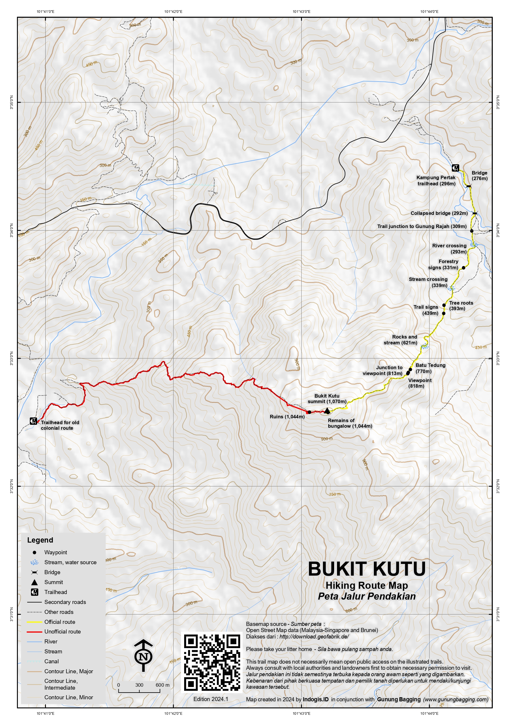
Bukit Kutu is one of the most popular hikes near Kuala Lumpur and used to be a hill station in the colonial era. Its name means “flea hill” but was also known a century ago as Treacher Hill after William Hood Treacher, British Resident of Selangor. It takes around 3 hours up and 2 hours back down and is now most commonly hiked from Kampung Pertak, Kuala Kubu Baru which lies to the north of the range. However, the original route one hundred years ago led up from the other side directly from Kuala Kubu Bharu (or KKB as it is often abbreviated by local people) via a 15-kilometre bridle path.
The summit offers great views from some precarious-looking boulders and even though the hill is not especially prominent – due to it being in the same large mountain range as the higher Gunung Rajah (1,685m) and also Ulu Kali (1,772m) at Genting Highlands – it is an absolute must for all hikers in Malaysia because there are so many interesting things about it. Be aware that dogs from the village are likely to follow you all the way up and all the way back down again.
Bukit Kutu was first established as a minor hill station in 1893, with two bungalows being constructed in 1895 and 1904. Each apparently had a telephone, fireplace, telescope and there was also a tennis court. The bridle path was regarded as poor quality and ultimately the hill station fell into disuse, being mere ruins by 1935. The hill was also bombed by the Japanese during the Second World War. By the mid-twentieth century the hill station was a ghost town. And in 2023, a chimney above a fireplace, entrance steps and two wells is all that remains of one of the two bungalows near the summit.
The following describes the route up from Pertak.
From the Pertak trailhead (296m) where there is plenty of space to park vehicles alongside the Pertak river, the trail leads via a bridge (276m) over a pleasant river, then a damaged and collapsed bridge (292m) which just about makes it possible to get across safely except after incredibly wet weather (the same kind of conditions which must have led to its collapse) and then an unmarked trail junction for Gunung Rajah (309m) on the left. Continuing right, there is another river crossing (293m) and this time you must wade through. This has been known to be too deep to cross safely on a few occasions so do be careful. It is worth considering whether to keep your shoes on or not as beyond this point there are no more major rivers to cross where you feet will get wet.
After some standard forestry warning signs (331m), there is a minor stream crossing (339m) before reaching some very impressive tree roots (393m) which appear to cascade across the path from a nearby tree. It’s one of several good spots for photographs. Not long after this there are a couple of trail signs (439m) at an obvious rest point.
Next, you will find yourself near some rocks and another stream (621m). After this is the spectacular Batu Tedung (770m)which means ‘cobra rock’ in English, not because of there being lots of cobras in the area but because the huge boulder resembles the head of a cobra from certain angles. It is a genuinely enormous boulder and a wonderful point of interest on the trail. Once round the side of the rock, there is actually a minor junction on the left to a little viewpoint (813m with the viewpoint itself just a couple of minutes beyond at 818m).
The trail is very pleasant from here and eventually you will reach the remains of the bungalow (1,044m) which are primarily comprised of the fireplace and chimney, plus the steps to the door a few metres away. There are also two wells which have unfortunately been used by irresponsible hikers as a litter bin for their plastic drink bottles.
The Bukit Kutu summit boulders are just a few minutes beyond and above the bungalow chimney. Most online sources state an elevation of 1,053m but this seems to refer to the ground at the base of the boulders where there is a cement block, possibly once used for map-making. Based on GPS readings the true elevation at the top of the rocks appears to be in the region of 1,070m. Take real care on the boulders, which are a cluster of smooth egg-like rocks with ladder sections tied with rope to them. From the top you should be able to see beyond the Selangor river reservoir below to the peaks of the Titiwangsa Range northwards near Bukit Fraser (Semangkok, Twin Peak, Pine Tree Peak, Gunung Gap, Gunung Ulu Semangkok) and eastwards towards Gunung Rajah.
About 300 metres beyond the summit, or less than five are the ruins (also 1,044m) of a taller structure than a bungalow, also with well-preserved steps. These ruins are also well worth visiting though the original use is not clear.
Several black and white photographs of the bungalow near the summit of Bukit Kutu are available online, once of which has been colorised. These images date from 1921 and the bungalow appears very similar in design to those found on Bukit Larut, or Maxwell Hill, near Taiping. One, taken outside, shows a man relaxing on a seat on a lawn in what back then was a garden. Hills can be seen in the background, and the front door steps to the bungalow are some of the few remaining relics still exisiting up there a century on. According to a local Malaysian blog post written in July 2011 by Shiek, the man on the chair is the grandfather of an Englishman named Tony Wright from Plymouth who happened to be hiking Bukit Kutu on the same day as the blogger in 2011.
A second photo is equally fascinating and is taken inside the bungalow, with a small table and some wicker chairs in front of a fireplace. The same fireplace and chimney column is the one which forms the main remains of the bungalow on Bukit Kutu today. It’s incredible to see how quickly the jungle takes back the work of humans, although it is not clear to what extent the bombing by the Japanese impacted the buildings here or if the British destroyed the buildings as the Japanese forces advanced.
Tony Wright also mentioned the existence of a sanatorium, or building for helping those who are sick, and this could potentially refer to the ruins on Bukit Kutu which exist around 300 metres away and are definitely not the ruins of a single-storey bungalow but a taller structure. Or it could be that the ‘sanatorium’ refers to Bukit Kutu hill-top in its entirety as a place of recuperation away from the stifling heat down at sea level.
Bagging information by Dan Quinn (August 2023)
Trail Map
For a high quality PDF version of this and other trail maps, please download from our Trail Maps page.
Practicalities
- Getting there: For Malaysian domestic flights and flights within Southeast Asia, for example to Kuala Lumpur, we recommend Baolau. About 90 minutes by car from KL. There is also a train station in Kuala Kubu Bharu but you will need onward transportation arranged to get to the trailhead.
- Guides and GPS Tracks: Want a PDF version for your phone? Looking for a guide? Need GPS tracks and waypoints? Bukit Kutu information pack can be downloaded here.
- Permits: Required, along with an official Selangor mountain guide.
- Water sources: Several rivers and streams as far as 621m on the Pertak route but best to take enough of your own.
- We recommend Safety Wing as travel insurance for overseas travellers and tourists hiking up to elevations not exceeding 4500 metres.
Local Average Monthly Rainfall 
Location
Click on the blue arrow ![]() (top right) to see your current location on the map
(top right) to see your current location on the map
Hi Dan. Just found your blog post about Bukit Kutu. I am really pleased to know that the ‘then and now’ pictures (my grandfather’s ‘then’ and yours now) were so useful and informative in your hike up the hill. Sheik Stone’s account is very good, isn’t it. He was a local hiker I met on my day there. I also shared my grandfather’s pictures with a local historian, Jimmy Chew, who’s written a very interesting history: https://www.jimmychew.com/Outdoor/Non-Camping/Remembering-Treacher-Hill-2012/i-vqdWF4D
Maybe you’ve already seen this, but I thought I’d mention it.
Happy hiking!
Hi Tony. Great to hear from you, and thanks for the link to Jimmy Chew’s site. I will send you an email later today. Season’s greetings! Dan
There’s a brief mention of Bukit Kutu in Spencer Chapman’s ‘The Jungle Is Neutral’ when he describes a journey in 1943 in which he ‘struck the foot of the wide path leading to the remains of the stone rest-house on the summit of Bukit Kutu (3,454 feet), which has been flattened by gunfire from Rawang during the Japanese advance’.
Despite its low prominence, Bukit Kutu is a great day-hike. Not only is the trail interesting, it also has great views at the top and historical significance. It took us just 2.5 hours up, and 2 hours back down. My guide warned me that even at 6:45am on a Monday there would be an Orang Asli ‘roadblock’ where you are required to pay for parking. 1 ringgit is fine in 2023, but have your note ready.
There are loads of parking spaces, and this probably shows how busy it could get on a weekend, or rather how busy it used to get before a permit and guide were obligatory. One of the funniest things was that 4 village dogs joined us just after the second bridge and followed us all the way to the peak. They were waiting for food, but on this particular day they didn’t get any! There were no other hikes up there, but a few camping down near the trailhead.
Looking at the ruins at the top, and comparing them with photos from a hundred years ago, it is tempting to consider if the same fate will ever befall Genting Highlands and its casinos and malls!
After the hike I drove into KL and started looking at short hikes I could do, like Bukit Lagong and Bukit Broga. Unfortunately, the permit situation has made all of this much more complicated, if you want to follow the rules and not be at risk of a massive fine.
After a good breakfast, I decided on a visit to Pejabat Hutan Daerah Selangor Tengah to ask what’s what regarding Lagong and Broga. It took nearly an hour to get there, parking was difficult and the tiny office was not easy to spot. A little room for customers with a counter space in wall to the office far too low for standing customers but perfect for staff sitting down on the other side of the counter… everything was to suit the workers rather than the hikers.
Anyway, I was informed that even for Broga Hill I would have to print out a physical sheet of paper to give them to request permission to go for a walk. They had a printer but would not let me use it or give me a print out. I told them I was staying in hotel. I was told to go to a print shop, and I tried to find it but couldn’t. I asked him if he had any interest in making it simple for customers but I think I was wasting my time, especially as a foreigner. This is the system, so we must follow it. The usual.
In short it could take you 3 hours to sort out the admin for a hike that lasts less than 3 hours. Bukit Lagong is allegedly ‘already closed’, even though many locals still hike it, clumsy use of English but got me thinking that that really was the aim… to close them one by one! Not yet closed or already closed being the only options!!!
It was a terrible experience. So I opted for some lesser hills not requiring permits. For Bukit Saga it was near impossible to find the trailhead and upon checking Google maps reviews it appears the usual route is now forbidden. Another one ‘already closed’. As is the nearby hill to south called Bukit Apek. So I went to Bukit Dinding. Quite a nice stroll up an access road, an island of green amongst Kuala Lumpur. Watch out for the ‘Fukuyu’ bike track for bikers only, definitely a ‘fukuyu to hikers’! The true summit is a few metres inside the compound, inaccessible, and you can see the old Beirut poles. The highest spot outside the fence, just a metre lower or less, is a MTB launch pad in 2023.
Then I went to Bukit Kiara. Very pleasant, easy parking, well looked after, a model park for the others. It would be easy to come up with a great list of 10 or 12 KL hills to promote and protect but there are too many bureaucratic hurdles that at any one time at least a third would be shut.
I then had a quick trip down to Port Dickson, hiked out to Bukit Batu Putih, a lovely little rock promontory on the coastline, less than an hour roundtrip. I also visited a couple of very interesting and lesser-known megalithic sites near Tampin. Datuk Tua is the best and easy to find just metres from the main road in a special enclosure. Issues with my rental car continued and the engine just would not start after cutting out in the middle of a journey. Luckily I was near Pulau Sebang police station, so I managed to just aboout roll it down the hill and into the police station car park! The local garage came to pick it up and discovered that someone had rewired the stereo in a dangerous way that was pulling way too much power from the battery and that is why it kept cutting out. Not safe at all. I was happy to give it back to the rental company at KLIA in one piece.
And then it was home, back on Saudia to Manchester, trying to ignore the flight safety invocation and the image on the screens of a crazed man holding a coffee jug in an almost threatening manner.
And I’ll be back next year for more, assuming they haven’t all been closed.
A fascinating story and images… https://shiekblog.blogspot.com/2011/07/bukit-kutu-interesting-story-from.html