
Facts
- Elevation: 1,357 m (4,452 ft)
- Prominence: 1,357 m
- Ribu category:
 Kurang Tinggi
 - Province:
 Maluku Utara (North Moluccas)
 - Island: Makian
- Coordinates: 0.3189, 127.3911
- Rating:

 (1 votes) Add your rating
 Loading...
 - Other names: Mailoa, Mailowa, Solimongo, Powate
- Eruptions: 1550, 1646, 1760-61, 1861-64, 1890, 1988
- World Ribus ID: 69105
Photos


Bagging It!
Gunung Kie Besi is the volcano of the island of Makian, which lies in the volcanic chain off the west coast of Halmahera – Ternate, Tidore, Moti, Makian and Bacan. Like Gn Gamalama (Ternate) and Kie Matubu (Tidore), Kie Besi dominates the entire island leaving only a narrow coastal strip and the lower slopes for plantations. Coconut, nutmeg and cloves are the dominant tree crops with some canari and cinnamon. Wild pigs are feared for their size and ferocity, and are known to have killed people working in the plantations. In 1975, fearing a major eruption, the government transmigrated Makianese to Kao in northern Halmahera. The resultant disputes over land between the Makianese and the local Kao people became the spark that fuelled intercommunal-religious clashes throughout Halmahera in 1999-2000. The 1988 eruption generated a 10 km high plume with pyroclastic flows.
Makian is reached by speed boat from Bastiong port of Ternate. The trip by a chartered ‘speed’ takes about 1.5 hours. Otherwise, regular public ‘speeds’ take longer stopping enroute at Pulau Moti, in which case you will almost certainly need to stay overnight in a homestay on Makian. There is no official accommodation on the island, but it will not take you long to be offered accommodation by local residents.
Like Gamkonora (Halmahera) and Kie Matubu (Tidore), the active crater of Kie Besi lies at the southern end of the volcano complex. Crater walls/ridges extend towards the north forming a valley with its opening towards the coast. Most Makianese know the eastern ridge as ‘Kie Besi’ and the western as ‘Solimongo’. Accordingly, if you ask for the true summit of Kie Besi they will refer you to a crag on the eastern ridge when, in fact, the highest point most likely lies on the southern end of the western Solimongo ridge.
Do note, however, that as is common in more remote areas, it is perfectly possible to hear two completely different opinions on the namings of the various peaks. Indeed, various maps offer various names on the range including Mailoa / Mailowa and Solimongo. And to add to the confusion, according to the US Army map, the highest peak at 1,357m is ‘G. Powate’.
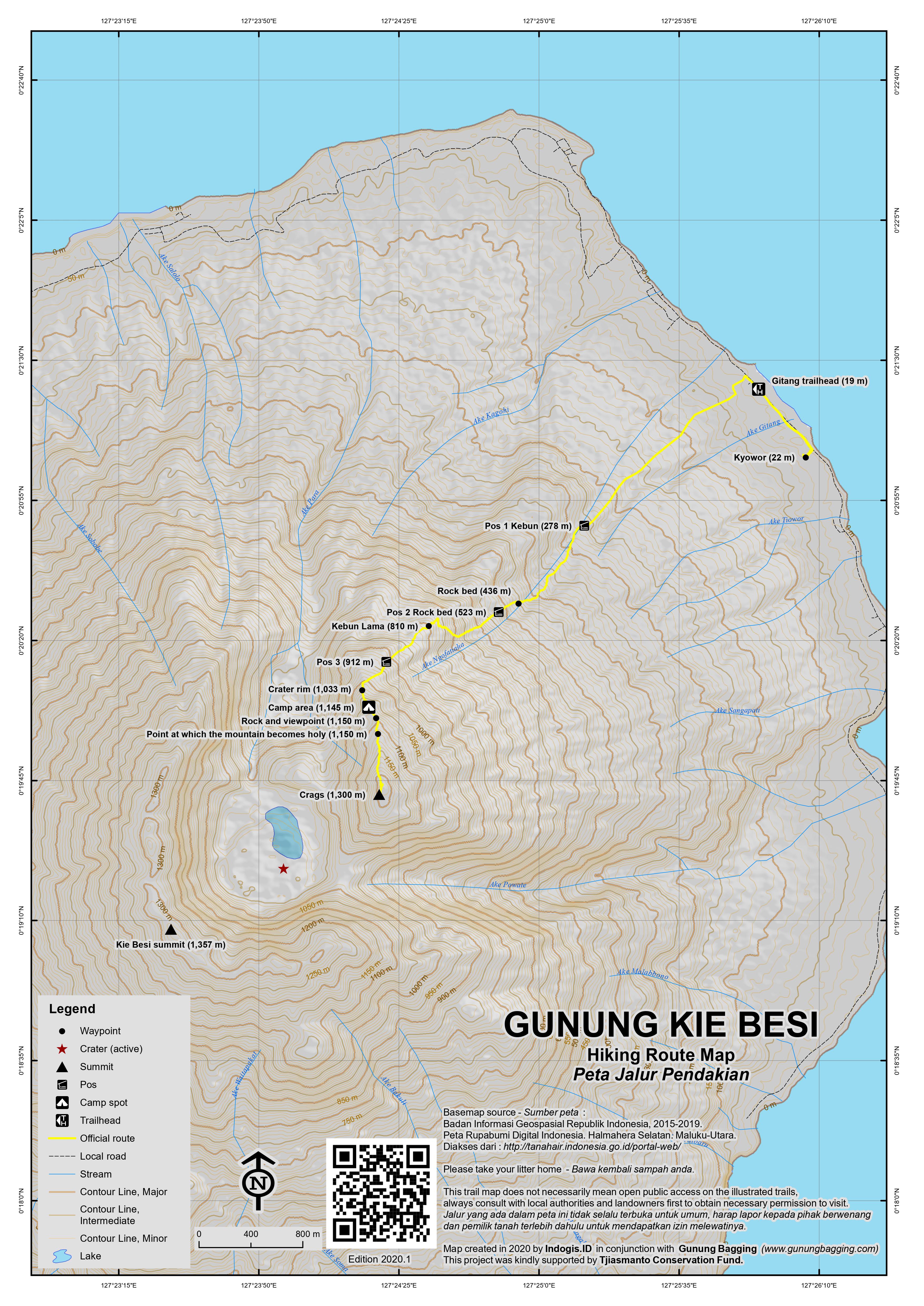
The Indonesian Volcanology agency informs that there are two routes up the mountain: one up the Solimongo ridge from the village of Sibelai to the north-west, and the other up the Kei Besi ridge from the village of Gitang to the north-east. Gitang is by far the most popular starting point and if there is a route up from the other side at Sibelai, it is likely to be very infrequently used.
Permission for the climb can be sought from the Gitang Village Head (or in neighbouring Kyowor) but larger groups may first be referred to the local Kecamatan (sub-district) office as “the Kei Besi ridge belongs to the Kecamatan, not the village”. Permissions are readily granted and the Village Head will depute guides. Guides tend to be village lads who may be keen to practice their English with you.
Makian is known to be a hot island, even by Indonesian standards, and the fact that the trail starts in the east means that the typical morning ascent requires most folk to take more water than they might expect to need. Ojeks can be used as far as Pos 1 (278m) which is at the end of a cement path in the kebun / plantations and where the trail properly starts. Ojeks will save you over half an hour and mean that you don’t have to start all the way down at sea level.
The climb follows the usual routine for these mountains – plantations (to about 560 m) then forest to the crater rim (at about 1,033m). The trail is fairly steep but well defined for the most part. Two areas of slippery rock are passed early in the hike (at 436m and 523m) – the second is regarded as some local hikers as Pos 2, although there is some confusion as to the numbering with different hiking club signs using different systems! Both of these rock areas can be either bone dry, contain small pools of water, or turn into streams, all depending on the weather. An old cocoa plantation (‘kebun lama’) is reached at about 810m. This is also known as Pos Persinggahan, and is soon followed by what at least some hiking clubs regard as Pos 3 (912m).
The climb from Gitang to the crater rim is, in total, about 4.8 kms and takes about 3.75 hrs. Cane grass, ubiquitous to the interface between the forest zone and the bare upper slopes of mountains in Halmahera, covers the entire rim making it difficult to see the mountain and crater except from several viewing points. However, many people have climbed the mountain recently and a well cut/trodden path now exists through the dense cane grass.
Around 20 minutes beyond reaching the rim, is a small camp area (1,145m) which is by far the best camp spot on the trail although there are some fairly flat areas back down at Kebun Lama. There is also a large rock (1,150m) protruding over the crater rim offering the first views of the mountain/crater. The mountain becomes ‘holy’ at this point and no urination is allowed beyond here.
The view itself is already excellent. “The crater is impressively deep (at least 400m), sharply indented around the rim, open on the north side and mostly cloaked in green, except for a small zone of gently puffing fumaroles on the southwest flank.” (John Hargreaves). The ‘active’ crater is currently rather quiet. The area surrounding the vent shows the remains of a recent volcanic mound, about 600 m across, that had apparently build up but then failed to erupt.
Many hikers only hike as far as this point, in order to take photos at the viewpoint, and some guides may think hikers only want to come this far. The trail beyond is a little more overgrown as a result.
Beyond this point, due south, two crags provide even better views. The first crag is at about 1,300m and takes about another hour to reach through heavy cane grass. The climb involves a very steep pitch of some 10-12 meters achieved by pulling oneself up on live cane grass stems. These aids will be depleted soon so local ingenuity with surely find an alternate route or fix a rope. The second, final crag is marginally higher than the first and another 30 minutes beyond. This crag offers the best views of the mountain/crater, of Pulau Moti and of Kiematubu on the island of Tidore across the ocean to the north, and of, what we believe to be, the true summit. It is possible to descend into the crater area from the ‘Kie Besi’ ridge beyond the two crags but this requires camping one night on the mountain, either at the protruding rock (1,150m) or down in the crater itself.
There are at least two possible contenders for the true summit. One shapely, pointy peak lies on the southern end of the Solimongo ridge (Google Earth) and appears quite steep to climb. An experienced local climber/guide informs that an Indonesian university group has attempted it but failed. The other contender is the flatter section of crater rim to the south-west, as per the US Army map. The best approach to these higher peaks would appear to be from the ‘Kie Besi’ ridge, crossing somehow to the ‘Solimongo’ ridge near the ‘active’ crater and exploring from there. Some technical climbing would almost certainly be required.
The descent from the ‘Kie Besi’ ridge to Gitang takes about 4.5 hrs.
Nicholas Hughes, October 2015, updated by Dan Quinn, October 2021.
Trail Map
For a high quality PDF version of this and other trail maps, please download from our Trail Maps page.
Practicalities
- Getting there: Speed boat from Bastiong port in Ternate. In 2021, there are two daily services, leaving Bastiong at 6am and also in the afternoon, and returning from Makian at 6.30am and 9am. Therefore there is no way to get back to Ternate after your hike without chartering or simply waiting until the following morning. Note also that you probably won’t be able to get started hiking before 9am if you take the regular speed from Bastiong at 6am.
- Guides and GPS Tracks: Want a PDF version for your phone? Looking for a guide? Need GPS tracks and waypoints? Kie Besi information pack can be downloaded here.
- Permits: Ask the Village Head at Gitang or Kyowor to refer you to the Kecamatan (sub-district) office to report/register before climbing.
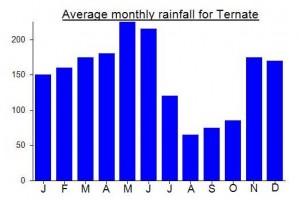
- Water sources: None except after rainfall; in dry season carry at least three 1.5 litre bottles.
Local Average Monthly Rainfall (mm):
Location
Click on the blue arrow ![]() (top right) to see your current location on the map
(top right) to see your current location on the map
There’s not a lot of info online about getting to Makian. The only boat schedules appear to be the slow ferries heading down to Bacan via Makian, taking about 4 hours from Bastiong to Makian. So it came as some relief when I got to Bastiong at 5am to find that yes there was still a daily speed boat leaving at 6am to Makian. Indeed, there are two, with one leaving in the afternoon and returning again the next morning from Makian.
Quite bizarrely, when I told a guy at Bastiong that I was going there to hike Kie Besi he started go on about ‘Mister John’ from Jakarta! With no prompting whatsoever. Whether this man had an incredible memory, or there is another Mister John out there who likes hiking Kie Besi, or simply that so few foreigners go to Makian that it becomes an immensely memorable occasion is unclear!
On this occasion, the boat was not overloaded at all, with only about half the seats taken. Perhaps it depends which day of the week it is. One young woman was reading a book on feminism!
Two stops on Pulau Moti, as expected. The second one allows great views to Makian and the various peaks on the rim. We arrived at the first pier on Makian at 0813, but there are so many piers that it depends on what your plan is as to where you get off. There’s even a small pier for Gitang itself. I got off at the second stop, before Gitang, as it looked like the main place, with a cluster of folk hanging around.
The first ojek chap who offered his services ended up providing me with accommodation in his home and providing me with his son and friends as guides. As has been noted, you probably won’t get just one guide but two or three and they will all want paying. Not a huge sum, but best err on the low side in negotiations instead of later having to fork out three times as much when it turns out you need to pay all three whatever money you mentioned initially!
It may take some time for guides to be found and be ready, so best try to arrange by phone in advance so they can meet you at the pier of choice and start immediately. Ojeks through the pleasant kebun is very much recommended so you can start up near 300m rather than sea level. It’s roasting hot here as noted, and we didn’t get going until 0950! Not ideal.
Makian is also known as Pulau Kenari, as many kenari trees grow here, sort of similar to a walnut or almond. Indeed, one of the speedboats is called Pulau Kenari. You may also note a few other interesting things like the size of the papaya fruits here. Absolutely enormous. Very few foreigners visit so expect to be photographed…. a fair bit indeed. Friendly locals.
The trail itself was fairly well defined except in the middle section before Kebun Lama. A few fallen trees meant finding a new route round and up the steepest bit of trail. This was manageable on the way up but we had torrential rain on the descent and this section became treacherous! Hopefully it will get easier as this particular section becomes better defined.
Up on the rim we got a view from the protruding rock just before low cloud swirled in. Very hot up there in direct sunlight, but suddenly chilly when the cloud comes in. Easy to see the higher peak that Nick H and friends explored back in 2015.
The guides sat and ate and the weather worsened. At one point a flash of lightning almost hit us, with one lad putting his finger in his ears and running for cover! As it was already late, the weather was deteriorating, and the views were limited because of cloud, we reluctantly decided against heading to the higher crags, as there would have been no views up there anyway. But it’s the place you want to be if you want to see Tidore and other islands in the distance.
None of the guides had heard of a trail up the other side of the volcano, and naming of different peaks was unclear. But they often go down to the crater floor, meaning 1 night camping on the mountain. Recommended…. If you have time to do so.
The next morning I got the boat from the Gitang pier. 0640, and leaving from the bigger pier further north (not the one which serves the really big ferries) at 0707. On the way back, the speed only called at the southern end of Moti, then heading up the west coast and direct back to Bastiong.
Being a group of eight, we hired a speed boat for a full day returning the same evening, at the cost of Rp 5,000,000. This amounted to about twice the regular fare on public boats but was well worth it to make the climb and return to Ternate in one day. We paid the three guides, deputed by the Gitang Village Head, Rp 100,000 each and boys who helped to carry out day packs including three large bottles of water Rp 50,000 each.
Our attempt to bag Kie Besi ended in frustration, as the promised “puncak” turned out to be only a protruding crag on the northeast crater rim, 200m below the actual summit.
Getting to Makian Island requires you to be at the Bastiong port in Ternate at 5 a.m. After an hour or so of loading up passengers and a two hour journey, with stops at Moti, the speedboat will reach Makian Island. (Both going and returning our boat had too many passengers, too few lifevests and a disturbing roll in even the gentlest of swells, so check the weather forecast before you set out!) I got off at the first port in Makian, which locals call “kecamatan”. Finding a house to stay in and a guide was easy, but your guide will insist on bringing a friend to help clear the trail.
Our 9 a.m. start time was undesirably late, but we were able to save time by taking ojeks through the lovely spice gardens for 3 km inland, giving us a starting altitude of 200m. Even so, this hike is extremely hot, so double your normal water supply.
The trail is a steep but mostly well-defined plantation and forest trail up to an abandoned nutmeg orchard at 860m. After this, the machete work is almost constant, especially after you enter a sosa reed area higher up the ridge. Dwarf-like stature and a tiny backpack would be advantageous here. Definitely don’t take up a tent, as there are no pitches anyway.
At 1150m, you emerge on the crater rim on a boulder that offers views all the way around the crater, provided that the mist lifts.
The crater is impressively deep (at least 400m), sharply indented around the rim, open on the north side and mostly cloaked in green, except for a small zone of gently puffing fumerolles on the southwest flank.
It’s hard to identify visually which of the several peaks around the crater rim is the true summit, but on the google map it’s shown as being in the southwest corner. You could try asking in villages on the west side of the island if there is a way up to the true summit; villagers in the north deny that there is any such trail.
For the route we did up to the crater allow at least 3 hours up and a similar time down.
The boat back to Ternate leaves at about 7 a.m., but be sure to board as early as possible before the overloading starts.