
Facts
- Elevation: 1,715 m (5,627 ft)
- Prominence: 1,715 m
- Ribu category:
 Kurang Tinggi
 - Province:
 Maluku Utara (North Moluccas)
 - Island: Ternate
- Coordinates: 0.8091, 127.3330
- Rating:

 (9 votes) Add your rating
 Loading...
 - Eruptions: 1510, 1538, 1561, 1605, 1635, 1643, 1648, 1653, 1659, 1676, 1686-87, 1737, 1739, 1763, 1770-75, 1811-12, 1814, 1831, 1833, 1835, 1838-47, 1849-50, 1862, 1864, 1868-69, 1871, 1895-98, 1907, 1911, 1918, 1923, 1932-33, 1938, 1962-63, 1980, 1983, 1988, 1990, 1993-94, 1996, 2003, 2007-08, 2011-12, 2015, 2018
- World Ribus ID: 69056
Photos


Bagging It!
Gunung Gamalama is the volcano of Ternate, which lies in the volcanic chain off the west coast of Halmahera – Ternate, Tidore, Moti, Makian and Bacan. Like Kei Matubu (Tidore) and Kei Besi (Makian), Gn Gamalama dominates the entire island leaving only a narrow coastal strip and the lower slopes of the mountain for plantations. Coconut, nutmeg and cloves are the dominant tree crops. The Sultanate of Ternate grew powerful through control of the clove and nutmeg trade throughout the eastern region and, often in conflict with the Sultanate of neighbouring Tidore, entered into intrigues and conflicts with European powers – Spanish, Portuguese, Dutch and English – over the spice trade from the 16th century onwards.
Gamalama is highly active, erupting most recently in 2015. The 1770s eruption created what is now Danau Tolire Besar, a large crater lake on the north-western side of the volcano. The 2015 eruption has changed the face of Gamalama’s volcanic cone with a large vent appearing on the face that climbers normally ascend to the crater rim. Not surprisingly, the mountain is sometimes closed due to volcanic activity and it would be very unwise to ignore local warnings.
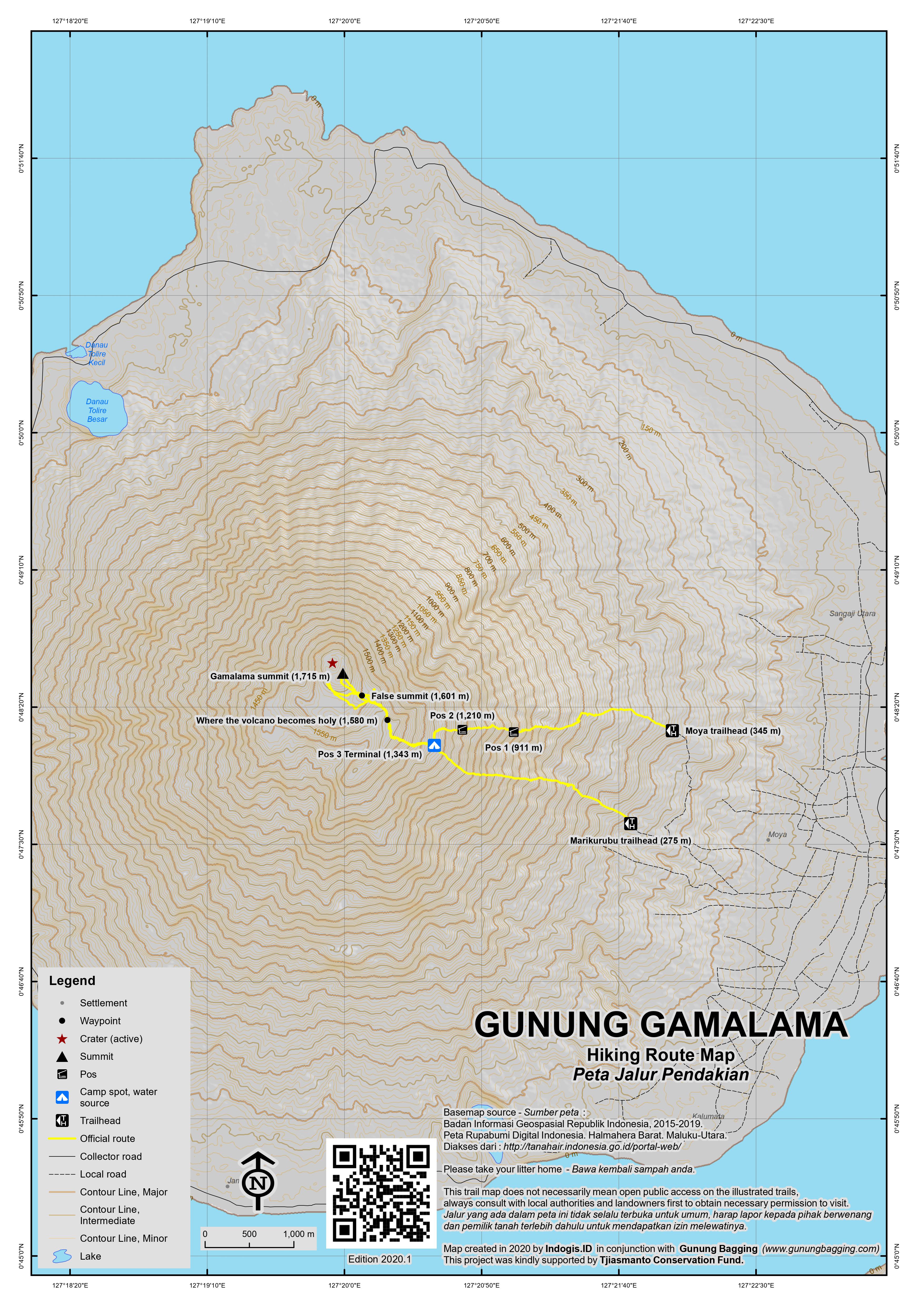
There two routes up Gamalama from the town: from Marikurubu (about 275 m) and Moya (about 345 m). The Marikurubu track is steep initially and easy to become lost on the descent – although you will invariably end up somewhere near the start point. The Moya route may be a bit longer but has a much more clearly defined track used by villagers to work their plantations, is a much steadier climb, and passes through lovely, old cinnamon, durian, nutmeg and clove plantations. Finding a guide at Moya should be no problem. Hikes do not get much more fragrant than this.
The climb from Moya to an open camping area, known as ‘Terminal’ (1,343 m), takes about 3 hrs. The trails from Marikurubu and Moya meet at this point. Thereafter, the trail ascends to the point at which the mountain becomes ‘holy’ (about 1,580 m, 1 hr). Several steep ravines are crossed in the process.
Most mountains in Halmahera have a point where they become ‘holy’ – perhaps from earlier animistic beliefs! While your guides may not be able explain the origins of these beliefs, they do take them seriously so be respectful. Urinating beyond the ‘holy’ point is forbidden. Gamalama’s ‘holy’ point is at a high point in heavy cane grass from where one gains a first view of the mountain’s volcanic cone.
From this point, the trail descends and passes through heavy cane grass until emerging onto a ridge that looks directly onto the volcanic cone of Gamalama. Several graves, whom locals believe are of earlier sultans, are on this ridge.
Subject to Gamalama’s level of activity, you can walk down into the small valley below and begin the climb of the cone to the crater rim. Since the 2015 eruption and formation of a vent on the southern face, the ascent would have to be up the western face. This ascent takes about 45 minutes climbing up very sharp, often loose rocks. The edge of the crater is very hot underfoot and the crater very active. Sulphur gas blows across the peak continuously.
In good conditions the views are fantastic. The perfect cones of Kie Matubu (Tidore) and Jailolo (Halmahera mainland) and other small islands nearby are visible.
The descent to Moya takes about 3-4 hours. At ‘Terminal’, take the left-hand track to Moya – the right-hand track leads to Marikurubu, which is not preferred.
Bagging information by Daniel Quinn, updated Nicholas Hughes, October 2015
Trail Map
For a high quality PDF version of this and other trail maps, please download from our Trail Maps page.
Practicalities
- Getting there: There are plenty of flights to Ternate island from Jakarta (usually via Manado and/or Makassar).
- Guides and GPS Tracks: Want a PDF version for your phone? Looking for a guide? Need GPS tracks and waypoints? Gunung Gamalama information pack can be downloaded here.
- Trip planning assistance: Would you like Gunung Bagging to personally help you in arranging your whole trip? Please contact us here.
- Permits: None required but take a photocopy of your passport photo page just incase.
- Water sources: Water is available at ‘Terminal’ but better to be self-sufficient; take sufficient supplies with you.
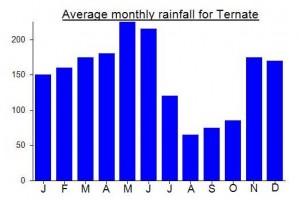
Local Average Monthly Rainfall (mm):
Location
Click on the blue arrow ![]() (top right) to see your current location on the map
(top right) to see your current location on the map
I just climbed the volcano today and had absolutely fabulous views all around.
Started from moya where it is probably possible to get an ojek from a local up through the plantations to make it almost all the way to Taman Love. Which is a newish campsite for locals at the weekend. Where apparently it gets busy. Today (a Thursday) there was nobody there. In my view this was the hardest part of the trek from moya. Could perhaps cut 300 meters of elevation by taking an ojek.
Taman love to pos 1 is very slippery even in the dry. Rain seems to have washed the sleep path smooth. There are very little places to step and I cannot imagine doing this is the wet.
Pos 1 – 2 gets a little better but after pos 2 the climbing was sleep but easy.
A very pleasant but tough hike. 5 hours to the summit from moya and around 4 hours down for me today.
Cheers
Instagram Sam_indowild
Hi Sam, I am in Ternate and would love to climb Gamalama. Do you by any chance have a telephone number of the guide you went with?
Thank you very much!
Francien
Apakah anda ingin mendaki, kalau gitu kita barengan no 082346519667
Hiked up Gamalama from Moya under very stormy conditions. The path was littered with broken branches, fallen trees and bamboos, and a thick carpet of leaves. Very slippery as a result. Completely in the clouds from the altitude of 700m onward, no views whatsoever. One of us ventured to the top of the cone where he was very lucky to experience a short window of a few seconds of clear weather, but at the rim it was 10-20m visibility at most. As with most mountains in Malut, a lot of garbage all along the path.
I climbed this mountain in Nov 2016.
The day after arriving from Jakarta I took an ojek up to the village of Moya to find a guide. We ended up riding around the village for about an hour asking people for directions to the guide’s house. Once there we found that the guide had already left for the peak with other climbers. I arranged to engage the guide the next day. The next morning, however, it was raining. The day after was fine but I couldn’t locate my ojek driver or the guide. I began to climb Gamalama myself but lost the path at a ravine near where the clove trees stopped and the jungle started. After this I called it quits for the time being.
I decided to head across to Tidore on the ferry. I headed for the village of Gurabunga, where I met the headman, Abdullah, who gave me permission to climb Mt Kiematubu but couldn’t get a guide. I set off up the path at the back of the village and before long got lost in the long grass. Some local guys wielding machetes, who were working collecting cloves I guess, helped me get back on the path – but further up I got lost in the jungle several times and cut my leg open on some rattan. I gave up and went down to the village. Gurabunga itself is worth the trip with green and purple cloves and red mace left out to dry. After visiting a couple of the Portuguese forts on Tidore I headed back to Gamalama. I managed to find my ojek driver and guide and made it up Gamalama. The walk up is steep but not difficult, it took around three and a half hours at the most. At the top there is a plateau of long grass and then a two hundred metre rocky hill which contains the crater – my guide, in his sixties with no shoes, didn’t accompany me on this final bit. The crater was belching sulfur and there was only one other climber up there. Clouds had rolled in robbing me of views of Tidore, Makian and Halmahera. However, I enjoyed the experience – in the afternoon I went to the Sultan’s Kraton, where among othe rthings you can see 16th century Portuguese Armour.
The forts, graveyards, villages etc on Ternate were all worth visiting for those interested in history. The food wasn’t bad either, there is even a mall – but be aware that prices are much higher then Java as everything has to be imported. Tidore seems to have its own micro-climate and was way hotter than Ternate. The way to get around Tidore is Benkor rather then ojek. The ‘city’ of Ternate I liked but Soasio the main town of Tidore doesn’t have much going for it.
My advice for visitors is to plan ahead on getting guides – I ended up staying a week between these two islands (which I was happy to do) and only got up one of the mountains. Also it’s a place where you’d be best to speak some Indonesian.
Hi,mr.frank apa kabar?saya suka dengan cerita anda tentang maluku utara.yaitu ternate dan tidore.
Baik baik aja Basri…Apa Kapar? Anda masih mendaki gunung Gamalama?
Hello,mr.Frank when you want to come in indonesia again?i always waiting for your coming really.
Hello,Mr.Frank how are you?i am Basri.now i want to tell you about my new phone number and my address now,if you want to come here again,i always waiting for you are.we ever climbed the Gamalama Mountain.
This is my hpone number 082190654149 if you want to call me or whatsapp me.
I climbed Gamalama last Thursday morning with fantastic views from the top over the “four mountains” with blue sky and some light layers of morning mist over the seas.
I found it an absolutly amazing view over a stunning archipelago, one of the best I´ve seen and can only highly recommend it.
As I used this fine informative site to find inspiration and information beforehand, I would like to update a few infos I would have liked to have.
I stayed at Nusantara Hotel, good place though over my usual pricerange. Cheaper accomodation seemed hard to find in Kota Ternate, but on our drive down from Marikurubu we passed a homestay that should be cheaper and is in a nicer, more quiet location.
Basri´s phonenumber in John´s post is not active anymore, but staff at the hotel managed to put me in contact with him.
As Basri was busy with work the day I intendet to climb, he put me in contact with a friend named Idod who also climbed Gamalama several times and went with me the next morning.
He picked me up at 5:30 at my hotel and we were walking from Marikurubu village shortly after.The first half hour we used a torch before there was enough “daylight”.
About half way up we had fantastic views of Tidore in the early morning light.
As I was concerned about potential clouds rolling in, I raced ahead and reached the caldera behind the high grass after 2 hrs. The views were absolutly amazing.
From there, after a short descend, we started the final ascend at the less steep looking left side of the cone.
I found ascending the ravines where the water has washed out the loose soil easier and more stable to get up on. It is a good idea to stay close together as it is steep enough for some rockfall if you break out some of the bigger rocks you want to hold onto.
Gamalama was definetly active, smoking and smelling, but didn´t seem dangerous.
Total climbing time was about 2,5 hrs but I was completly sweaty wet and do climb quite a lot of mountains regulary.
Try to be up there as early as possible to avoid clouds and enjoy the morning light.
We stayed for about 1,5 hrs and took a lot of pictures.
To contact the guides, Basri (HP 082395443843 or 085757447488, mail bastonthebumi@yahoo.com ) and Idod (HP 085340762013, mail Idodmaudjud@gmail.com )it is a good idea to give a few days notice as the both study and work.
I climbed with Idod, a very nice and knowlegeable guy who speaks very good english.
They also have climbed most, if not all the other volcanoes in the region, including Halmahera should you be interested. I will definetly return with some more time.
If “gunungbagging” moderators are interested in some more pictures for the gallrey, let me know.
Mr.Steffan this is my phone number 082190654149 if you want to call me or wharsapp me.
Halo pak Basri, apakah masih Aktif mendaki? Saya hubungi nomornya bapak sepetinya sudah tida aktif. Apakah bapak bisa jadi guide untuk gunung kie Matubu Tidore?
Despite newsworthy eruptions in December 2011 and September 2012, Gamalama was open as usual for summit hiking in December 2012. With guide Basri (HP:085696422533) we started from the village of Moya (altitude 341m). Moya is up a separate road from Marukurubu, but still only about a 20 minute ojek ride from Kota Ternate. The hike is slightly longer but the gradient is gentler.
After registering with the local village chief and donating a pack of cigarettes, we set out on a steep but manageable plantation and forest path. At a clearing at 1360m, marked during our visit by a pile of campers’ trash waiting to be burned, the trail from Moya joins up with the trail from Marukurubu. About 10 minutes further up the trail passes an illegible warning sign and enters an area of reeds, as described in Dan’s report. However, the “sharp black volcanic rocks” Dan describes must have either moved or disintegrated during a recent eruption. The false summit is now easily reached at the top of a sandy ridge (alt. 1601m); unless you’re planning to geothermally heat your camp dishwashing water, you can leave your rubber gloves at home!
The final cone presents a dilemma. An ascent straight up the east side looks dauntingly steep. An easier approach is to move around to the south and walk up along the crater rim, but you might have more sulfurous gas blowing over you than you feel comfortable with. But there’s less gas as you move higher up the rim toward the summit, which stood at 1736m altitude on our GPS- perhaps it has grown!
According to Basri, the crater has altered substantially, with a large gash in the southwest corner, and new areas of gas emissions around the crater floor.
Views were good toward Halmahera, but not toward Tidore. We descended via the direct and steep route to Marukurubu. An advantage of this route is that if you missed the Tidore view from the summit, you get a second chance to see it through the trees, with Moti and Makian lined up behind.
Ascent time was 4h30m and descent 4h.
GAMALAMA ERUPTS. heres a report i found in the jakarta
post.http://www.thejakartapost.com/news/2012/09/17/volcano-erupts-e-indonesia-spewing-ash-lava.html
Java Lava climbed Gama Lama September 09 2011.Would expect a little more time 4.5hrs up, 3.5 dowm for most climbers.On descent as trail re-enters clove/nutmeg forest, esy to get on the wrong ridge and have to backtrack, so useful to have guide/use GPS at this point
Dan – an irrelevant but interesting fact for Muslims who may wish to pray in the ancient mosque of the Sultan of Ternate … Those who wish to enter the mosque are obliged to wear celana (trousers) rather thann sarong, as is customary for Friday prayers throughout Indonesia. The reason, as explained by the ulama, is that fishermen wear sarongs at sea and would return to the mosque for prayers in unclear garments. As the wearing of celena in mosques is quite unusual, the tradition may also have its origins in early Portugues-Spanish influence. Further research required!
Ternate and Tidore were the original and only source of cloves, bringing the Portuguese and Spanish and later the Dutch and English to these islands. The history of these islands and European powers’ attempts to exercise influence over the spice trade is recorded in “Turbuoent Times Past in Ternate and Tidore, Willard A. Hanna and Des Alwi, 1990, Yayasan Warisan dan Budaya, Banda Naira.
Visitors to Ternate should try to obtain as copy of this book locally if it is still in print.