
Facts
- Elevation: 1,259 m (4,131 ft)
- Prominence: 356 m
- Peak category:
 Spesial
 - Province:
 Maluku Utara (North Moluccas)
 - Island: Halmahera
- Coordinates: 1.6933, 127.8941
- Rating:

 (8 votes) Add your rating
 Loading...
 - Other names: The highest peak in the immediate area is known to locals as Karianga
- Eruptions: 1550, 1719, 1868, 1901, 1933-present
Photos


Bagging It!
Gunung Dukono is the northern-most volcano in the chain of volcanoes along the western side of Halmahera – from the south, Jailolo, Uno-Ranu, Gamkonora, Ibu, Dukono – and one of the most persistently active in Indonesia. Since 1933, the mountain has been erupting almost continuously. It is certainly one of the most spectacular active craters in all of Indonesia, and is very well worth the effort of travelling to northern Halmahera just to peer into its awesome crater and experience its violent activity.
The mountain complex has a low profile with multiple craters sometimes covered in deep ash creating a surreal moon-like landscape. The active crater Malupang Warirang emits violent roars every minute or so, like a dozen jet planes taking off, with plumes of ash billowing hundreds of metres upwards. With extreme caution and staying up-wind of the plumes, one can peer over the rim into Dante’s Inferno (Abandon all hope, ye who enter here), even into the vent itself from where the eruptions emanate far below the earth’s surface.
The usual route up the mountain starts at Desa Mamuya (only 13 metres above sea level), which lies on the coastal highway between Galela to the north (about 10 kms) and Tobelo to the south (about 14 kms). A guide is essential, not so much for finding ones way through the plantations as on other mountains in Halmahera, but for navigating through the surreal moon-like, sometimes ash-covered, landscape of ancient lava flows to the active crater rim, and for anticipating wind changes to avoid heavy ash falls. Contact the Volcanology Post or Village Head’s office opposite the trailhead junction at Mamuya for guides. Sign the visitors’ book as a precaution to record your presence on the mountain. Masks are advisable and can normally be purchased in warungs at Mamuya (where the villagers themselves occasionally experience ash falls). Protect cameras etc. from fine ash.
A jeep track passes through the plantations to ‘Terminal’ where the trek begins (about 8 kilometres, one hour on motorbikes, 370 m) although some guides say that ‘Terminal’ is further on at a large Pos (619m) on the trail itself. Either way, there are two main wooden shelters in the kebun, one at 319m (where your guide may check on the durian growing there) and one at 370m, and motorbikes can only go as far as the second. You can either walk this long section, or take an ‘ojek’ (motorbike) or plantation vehicle. An ojek is very much recommended as it will save you around two hours in each direction and most local village guides will offer it as included in the guide price. Note you may need to get off the motorbikes for some of the steeper sections.
The trek from ‘Terminal or Shelter 2’ is a steady climb to the initial crater rim (3.5 kilometres and around 3.5 hours or less) except for some eight small creeks/ravines to be crossed, notably at 647m and 795m where after rain or during the rainy season water is likely to be found. The forest zone is reached at around 500 metres and the ubiquitous dense, cane-grass zone in the mountains of Halmahera, at the interface between the forest and the bare mountain top, at around 800 metres. Views back down to the smaller Gunung Mamuya (933m) and the coast near Tobelo are possible from around 838m. Be careful in this area as there are a few minor junctions with no signs, so be sure to ask your guide to wait for you at junctions rather than marching on and leaving you guessing!
Finally, the outer rim (940m) is reached. On a small hill to the left you will see volcanology sensor equipment. This little peak is Gunung Dilekene. Down below is a plain of black volcanic sand, rather like a miniature version of Bromo’s sea of sand. Indeed, this outer rim is known as Tanah Lapang. Crossing it just takes a few minutes and it is from here that the first view of Dukono’s active crater, with its ash plumes and roars, is gained.
The trek to the active crater rim is about another one kilometre and takes between 1 hour and 90 minutes, depending on how much ash there is. From the other side of Tanah Lapang sand plain is a large expanse of ancient lava flows, jagged in places and smooth in others. When covered in very deep ash, the landscape here below the active crater is completely surreal. When there is no ash around, such as after heavy rain or during the rainy season, the landscape is perhaps less surreal but utterly unique and remarkable.
The higher up you get, the finer the views are back to the peaks of Gunung Gogodom (1,102m) and Gunung Bale-Bale (923m). You should be able to see the small islands off the coast near the town of Tobelo and perhaps even the large island of Morotai in the distance. Finally, you will emerge at the Dukono crater rim at about 1,150m. The crater is almost circular and funnel-shaped – about 400 m across and 200 m deep (guestimate!) It is possible, with care, to crawl up to the edge of the rim and peer inside – awesome, stupendous, fearful, frightening – as the vent roars and issues enormous clouds of ash. With extreme care, peering over the rim, one see directly into the vent from which the eruptions emit from the bowels of the earth below. A ‘selfie’ pole would be useful for extending the reach of your camera over the rim for photos direct into the vent below.
Ash plumes are emitted every minute or so rising some 500 m above the rim to be swept away gently in the direction of the wind. The sight of ash clouds being emitted from the vent below precedes the sound of the roars from the vent itself (sound travels slower than light). In 2015, two types of plumes were emitted, mostly pure white but also dark brown – the white plumes were accompanied by a roar like jet planes taking off, while the brown plumes were accompanied by a much more throatier, guttural sound. The latter produce much heavier ash falls that feel like light showers of rain trickling down on your head and body. No sulphur dioxide was smelt while on the active rim in 2015.
Many trekkers camp on the mountain, usually at the initial crater rim mentioned above or at a Pos (946m) on the crater side of the sand plain, to see the fireworks display within the active crater in the dark. In 2015, we descended at sunset, which proved to be a sensible move on that occasion, as the wind had dropped and ash from the plumes began falling across the entire area.
Reaching the highest point of the rim is dangerous and not advisable. Indeed, it is not the highest peak in the area anyway. A scan of Google Earth suggests that the highest peak near Dukono is known as Puncak Karianga (see below) which lies to the south-east of the active crater rim, and is not visible from the trek from Mamuya.
The descent from the active crater rim to the motorbike at 370m took about 3.5 hours, plus another one hour on motorbikes back to Mamuya.
To reach Puncak Karianga, it is possible to trek in from Desa Ruko on the main road between Mamuya and Tobelo, although this is a completely different trail and is likely to be less spectacular compared to the traditional Mamuya trail to Dukono crater. Furthermore, the Karianga trek is usually done as a two-day trek with one night camping on the saddle between Dukono and Karianga. Most local hikers do not visit Dukono crater rim from this side, or even go to the top of Karianga, but rather simply camp in the saddle between. It appears another 1200m+ peak lies several kilometres further south of Karianga, and could be a little higher than Karianga itself. The US Army map lists a Gunung ‘Kariang’ as 1,198m (likely an underestimate unless it refers merely to the saddle), Gunung Mede at 1,335m (likely a considerable overestimate – 1,235m looks closer), and may refer to what locals now call Puncak Karianga) and further south a Gunung Togohi (1,233m) which is probably densely forested and with no trail.
Bagging information by Nicholas Hughes and Remy Lanz (October 2015), updated by Dan Quinn (September 2021)
Trail Map
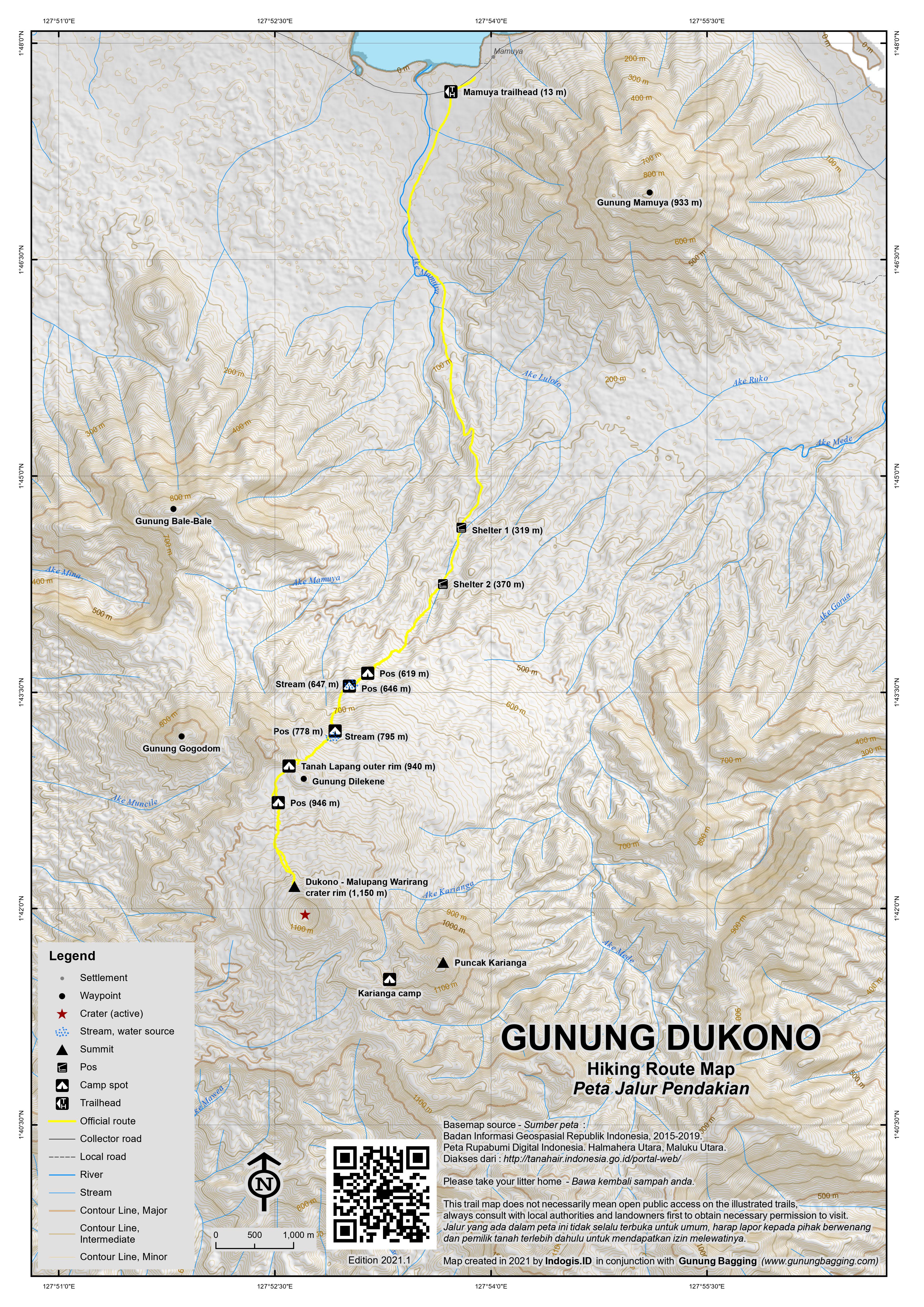
For a high quality PDF version of this and other trail maps, please download from our Trail Maps page.
Practicalities
- Getting there: The climb to Dukono crater rim starts at Desa Mamuya on the coastal highway between Galela to the north (about 10 kms) and Tobelo to the south (about 14 kms). From Manado, fly to Kao, the latter being 2 hours by road south of Tobelo. If starting from Ternate, speed boat to Sidangoli on the Halmahera mainland then 3.5 hours by car to Tobelo. The less interesting trek to Karianga starts a little closer to Tobelo at Desa Ruko.
- Guides and GPS Tracks: Want a PDF version for your phone? Looking for a guide? Need GPS tracks and waypoints? Gunung Dukono information pack can be downloaded here.
- Trip planning assistance: Would you like Gunung Bagging to personally help you in arranging your whole trip? Please contact us here.
- Permits: Register with the Volcanology Post or Village Head at Mamuya or the Village Head at Desa Ruko.
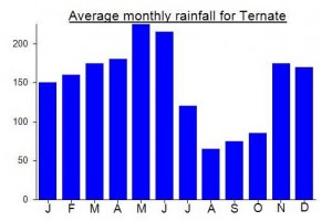
- Water sources: Enquire with guides. None available in the dry season; carry at least three 1.5 litre bottles if day trip; more if camping on the mountain. Water may be available in mountain streams in wet season.
Local Average Monthly Rainfall (mm):
Location
Click on the blue arrow ![]() (top right) to see your current location on the map
(top right) to see your current location on the map
Sad news: https://www.bbc.co.uk/news/live/c0k2g11j2plt Three hikers have died after Indonesia’s Mount Dukono volcano erupted this morning
Rescuers have found all the survivors from a group of 20 hikers who went missing after the eruption. Most have been evacuated from the mountain, though two have remained to assist in locating the bodies
Officials say the group – which includes nine Singaporeans – was hiking up the volcano despite a climbing ban
Mount Dukono erupted at 07:41 local time (22:41 GMT Thursday), sending a 10km column of ash into the sky, according to the Volcanological Survey of Indonesia
These guys were extremely lucky to make it back down alive.
https://www.dailymail.co.uk/news/article-13760711/Heart-stopping-moment-climbers-cheat-death-run-lives-volcano-erupted-8-000ft-tower-ash-reached-crater-summit.html
As all flights to Halmahera (i.e Manado to Kao – as Galela airport no longer serves Wings Air) are cancelled until October, I had to get a boat over from Ternate. For the west coast at Jailolo and Gunungs Gamkonora and Ibu, the pier you want is Dufa Dufa, not far from the airport. But for the east coast (Tobelo) you are better off making the shorter crossing to Sidangoli from a tiny little pier near a waterfront mosque. The speedboat owners will wait for 10 passengers usually, which could take some time, but the boy quoted me just Rp300k for the 30min crossing so I thought to save time I would charter. Once over at Sidangoli take an ojek for 3 minutes to the transport terminal where there are cars waiting to fill up for journeys on to Sofifi or Tobelo. 150k per seat to Tobelo. I waited quite a while but no other passengers showed up so once again I ended up chartering a car and driver up to Tobelo for Rp600k though I think you could bargain down to Rp500k assuming the car was a small one. The roads are not too bad so it only took 3hrs and 15min up to Tobelo. There are a few army/police checkpoints, presumably due to religious conflicts many years ago but none needed any extra time and all the guys manning the posts were friendly.
The first hotel I tried was (unbeknownst to me!) a quarantine hotel for covid-positive patients and the second one was full, but Hotel Johana, third one I tried, was fine and a short walk from an Alfamidi. Alfamidis and Indomarets are springing up on the east coast of Halmahera it would appear. Tobelo is fairly featureless and hard to recommend, and the hello misters got quite tiresome quite quickly, as usual shouted from across the street by random folk who would surely be mortified were they subjected to something similar whilst away from home!
I had hoped to arrange a Dukono guide in advance but had gotten nowhere. Finally I got a number for a local boy who has done it several times. He came round to the hotel but said he was too busy to guide himself but his friends in Desa Ruko could do it. The suggestion was Karianga, the highest peak near Dukono plus Dukono itself, but when most folk hike up to Karianga, they merely camp on the col between Dukono and Karianga, visiting neither. Anyway, the thing that made this a non-starter was the price of Rp1.5jt, a typical bule price, found often in Halmahera, presumably due to the volcano tour groups who visit and pay too high a price. This chap was trying to speak English to me, another ‘warning’ sign as it usually precedes an attempt to charge 3 or 4 times what an Indonesian would pay. They wouldn’t negotiate on price.
So, the next morning I got a car up to Desa Mamuya (Rp150k as it was still dark, maybe Rp100k would be doable during daylight hours), the traditional starting point for Dukono, though clearly there was going to be no realistic chance of bagging Karianga from this side, given the steep, dangerous edges of Dukono crater rim. Pak RT near the volcanology building at the far end of town was very helpful and soon found me a guide, Sadang, a local chap who works in the kebun, ideal. Strong and knows the terrain. Note the angkots seem to operate from around 6am between Tobelo and Mamuya and Galela so public transport is certainly possible. We agreed Rp500k for a dayhike, plus Rp100k for him to take me back to my hotel in Tobelo afterwards.
When we got the outer rim, he proclaimed it to be the ‘puncak’ and that if I wanted to go further I would have to pay more. I’ve encountered this a handful of times before, and when a guide says something like this, it is really hard to feel anything positive, especially given that no trekker would only want to visit the outer rim! Reluctantly I agreed to pay another Rp100k, meaning Rp600k for a dayhike, a considerable sum several times what he would be earning in the kebun, but perhaps indicative of the bule price charged to tourists. Obviously it’s a lot easier if there is a small group of you rather than just a single visitor!
And yet….. it is completely worth it as Dukono is one of Indonesia’s finest volcanoes and the experience of listening to the powerful sound of the eruptions, and peer down into the crater, is an incredible one! It is a bit of a hassle getting out here but completely worth it. Might be good to combine with a few days of relaxation on Morotai (2 hours by speedboat from Tobelo) which has a small airport with flights 2 or 3 times a week to either Manado or Ternate.
Tough to reach but thoroughly recommended.
We agree with C. Jung: Dukono indeed is one of the most spectacular craters of all volcanoes in Indonesia that I have climbed, now some 60! We climbed Dukono in October 2015, at the height of the dry season, departing Mamuya about mid-day and returning same day late night. We contacted vulcanologist Iwan (0852 40620660) the evening before to enquire about guides/fees, and received most unhelpful information from a guide that Iwan introduced us to and wanted to charge us Rp 600,000 per guide. Clearly, this guide was attempting to fleece ‘bules’ to the maximum. He even told a blatant lie that motorbikes were not available in the village and that we would need to take a plantation vehicle at Rp 1,000,000 to ‘Terminal’. In the end, we simply took a local taxi to Mamuya (Rp 300,000 return) and hired two guides at Rp 500,000 each inclusive of riding pillion on their motorbikes to ‘Terminal’. Try to insist on more powerful bikes with good tread for negotiating sandy slopes and workable headlights if descending in the dark. Share your headlamps with the drivers to see the track if necessary.
I climbed Dukono yesterday. I didn’t do a booking in advance, I just asked at the vulcanology office and they recommended me a guide. the cost wer 600Rp. for a 2d 1n trip. it was definately worth the money. without a guide it’s almost inpossible to find the right path. there is very very very much ash in the air so protect your camera and your important belongings. The most important thing is to bring a diving mask with you! otherwise it will be horrible to climb the summit because the ash in the air is very aggressive to your eyes. if you miss the mask, you will remember these words if you climb it, i promise you! i didn’t have a mask with me and i missed it so much. the crater is the best i’ve ever seen. so active! i climbed also merapi, marapi, kerinci, bromo, ijen, anak krakatau, rinjani soputan, lokon, karangetang and gamalama in indonesia and dukono was definatly my favorite! its a hard tour, but worth all effort!