
Facts
- Elevation: 2,085 m (6,841 ft)
- Prominence: 2,085 m
- Ribu category:
 Tinggi Sedang
 - Province:
 Maluku Utara (North Moluccas)
 - Island: Bacan
- Coordinates: -0.7370, 127.5244
- Rating:

 (1 votes) Add your rating
 Loading...
 - World Ribus ID: 69032
Photos


Bagging It!
Buku Sibela is the highest point of the island of Bacan and lies within Gunung Sibela Nature Reserve. It is also the highest peak in North Maluku province. Until quite recently, very few hikers had heard of it, but it is slowly growing in popularity and the superb views from the summit ridge make it well worth the effort getting to.
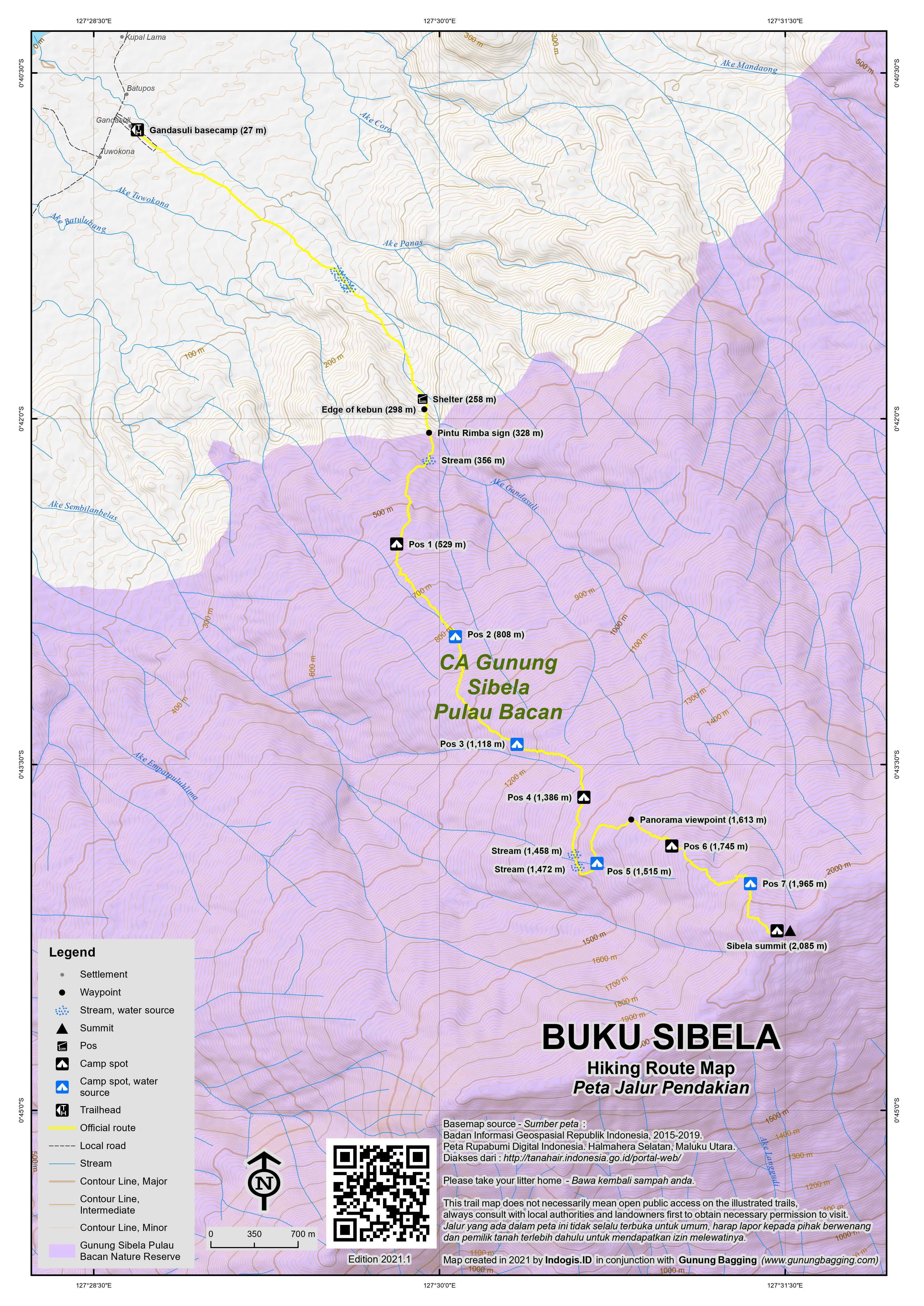
It takes most hikers at least 11-12 hours to reach the summit and 9-10 hours back down again so it is usually spread over three more manageable days, typically with the second night spent camping at the summit itself. Friends of your guide will usually take you by motorbike from the village basecamp (27m) in Gandasuli up a plantation track to an elevation of around 138 metres. From here, the trek properly begins through kebun, crossing a small stream four times, passing a wooden shelter with a couple of seats outside (258m) before a steep and overgrown section between the kebun and the Pintu Rimba (forest entrance, 328m). There are some reasonable views just before the start of the forest trail.
It is still a considerable distance to Pos 1 (529m) but there are many, many hornbills in this area so you have a very good chance of seeing them flying above you. Pos 1 is large enough for several tents and the forest here features some wonderful trees with huge buttress roots. The trail continues gently up to Pos 2 (808m) which you should have reached in around 4 hours. A source of water is down to the left. Beyond Pos 2 is an area of old kebun apparently from Dutch times. Ask your guide to show you what the colonialists planted here.
Pos 3 (1,118m) is next and there is a water source down to the right. Pos 4 (1,386m) is next, before the trail crosses two streams (at 1,458m and 1,472m). The trail here winds round to Pos 5 (1,515m), sometimes known as Camp Rusa due to the many deer in the area and with a very good stream for water. There’s even a small clearing just before the Pos with a citrus tree. If you have made it here on Day 1 then you have done pretty well.
The vegetation begins to change after Pos 5 and the first excellent viewpoint known as Panorama (1,613m) is soon reached. This is a great spot for some photos down to the ocean below. The trail then leads up to Pos 6 (1,745m) which is a lovely spot with even better views. Beyond Pos 6, the vegetation gets less dense, and the views improve. There are some pitcher plants in this area too. Ahead of you are the higher slopes of the mountain, and the steep cliff when it comes into view looks like it might present some serious challenges. Thankfully, it is not as difficult as it looks, as the trail drops down a little way to the left before a steep section with some ropes to hold onto before reaching Pos 7 (1,965m) which is a lovely small grassy spot with an old tree stump.
There is water down to the right just before Pos 7, but it may not be easy to find without guides and it is advisable to bring as much as you can up with you from Pos 5. It may not look too far from Pos 7 to the summit but there is a bit of up and down to be negotiated, plus some slippery logs to traverse, so it takes about 30 minutes.
The summit is well-marked and obvious; a grassy area with incredible views in all directions. It takes around 7-8 hours to reach the summit from Pos 2, but hopefully you managed to camp higher up on the previous night. The summit is a wonderful spot to camp and you should be able to see the town of Labuha below, including the little airport, the shapely Gunung Amasing, and right to Buku Rica, Bacan island’s other much more obscure Ribu. In the distance to the north it is sometimes possible to see Kie Besi on the island of Makian and Kiematubu on the island of Tidore, most usually in the early morning just after sunrise. To the south you may be able to see the remote island of Obi. The ocean glitters in many different directions. These views make Buku Sibela a truly worthy provincial highpoint, and there is no higher land until you reach either Sulawesi or Seram.
To descend by the same way is a long day’s trek of at least 9-10 hours. Hopefully you will have motorbikes waiting for you on the plantation track to take you back to the village basecamp.
Bagging information by Dan Quinn (September 2021)
Trail Map
For a high quality PDF version of this and other trail maps, please download from our Trail Maps page.
Practicalities
-
- Getting there: Turboprop to Labuha airport from Ternate, or the nightly boat between Bastiong (Ternate) and Babang (Bacan) which takes 8 hours.
- Guides and GPS Tracks: Want a PDF version for your phone? Looking for a guide? Need GPS tracks and waypoints? Buku Sibela information pack can be downloaded here.
- Trip planning assistance: Would you like Gunung Bagging to personally help you in arranging your whole trip? Please contact us here.
- Accommodation: There are several hotels in Labuha but it is recommended you book in advance to avoid having to stay at one of the less decent ones.
- Permits: Register in Gandasuli with your local guide.
- Water sources: Available as far as Pos 7, although Pos 5 is the last truly reliable spot.
Local Average Monthly Rainfall (mm):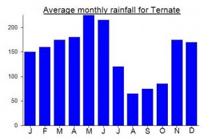
Location
Click on the blue arrow ![]() (top right) to see your current location on the map
(top right) to see your current location on the map
Up until quite recently it was very difficult to find information on hiking this mountain. Thankfully it is now fairly easy and the local guides on the outskirts of Labuha are very friendly and competent. I wasn’t the first Westerner to get to the top, however. Another British chap, living in Malaysia, visited a few years ago, according to the guide’s father, who was the guide in previous years.
My original plan had been to visit Halmahera first, but there are absolutely no flights to Halmahera this month due to travel restrictions and presumably lack of demand given the expensive PCR tests required. But there is still a flight one day per week from Ternate to Labuha on Bacan, usually several times a week in normal times. The flight was perhaps only a quarter full. Upon landing there was heavy rain, and a lack of umbrellas meant that a truck came to pick up passengers two-by-two to take them to the little terminal building. I had a coffee there, and was charged a ridiculous Rp25k for it. Harga bule?
No Labuha hotels show up on Traveloka so I thought I would just find somewhere when I arrived. This turned out to be a mistake, as they all seemed to be full! I finally found somewhere to rest my head, but it was so dirty and dodgy that I ended up leaving after a few hours and trying again at Hotel Janisy, one of the better ones, where thankfully a room was finally found!
The next day we got started early, but heavy, persistent rain meant we only got as far as Pos 2. The best itinerary is to get as far as you can on Day 1, ideally anywhere from Pos 2 to Pos 5. Then up to the summit on Day 2 and a long hike back down on Day 3. There was a small earthquake down near Labuha which we felt quite strongly as we sheltered in the rain at Pos 2!
As it was not clear quite how long it would take us from Pos 2 to the summit, we started at 3am. The guides were fine with this suggestion of mine…. quite keen to do things according to my plan rather than some rigid idea of their own which is sometimes the case with Indonesian guides.
The forests here are teeming with hornbills, especially below 1000 metres elevation. In decent weather you hear them frequently. We were up at Pos 7 by about 930am, going fairly fast and having very few rests. This is the last spot for water, though the exact location is off the trail to the right but your guide will know. The last 30 minutes on to the summit is energy sapping, but the views are often fabulous, especially at dusk and dawn. Although Pos 7 has enough space for a couple of small tents, the summit itself is much better for views and for space. There’s even a phone signal, with very occasional 4G (if you are lucky!) The summit is also referred to as Pos 8. Despite old maps suggesting a height of 2111m, GPS readings suggest around 2085m. There’s another top further on to the east, but although it looks a similar height due to the tall trees on it, it is about 15-20 metres lower.
The trek back down took 9 hours and was quite exhausting, not least because my boots were starting to fall to pieces, but also because of the bouldery terrain in parts of the kebun. Most folk will want to have a proper rest before heading onward to their next destination but I decided to get the night boat to Ternate from Babang (Rp130k for a ticket and place to lie down, departing 9pm or a bit after, arriving 8 hours later meaning 5 or 6am). There’s apparently a boat from the Labuha side too, but it seems Babang is a better bet (30min away by motorbike), and has a new, spacious terminal building. Proof of vaccination is required, but no antigen or PCR as Ternate is in the same province. You can board as early as 7pm though it’s hot with no AC turned on until 9pm.
The boat was quite busy, so I’d recommend booking in advance. Bear in mind though that they will most likely think you want a ticket for the same day that you book on so double check it. I had to get him to write it out again as he didn’t listen to me the first time. And even after this, when I boarded the boat, it turned out the boy had sold two tickets for the same seat/mat number!
When you get to Ternate, it’ll be Bastiong pier, which is for Tidore, Makian and other southern islands. There are tons of piers in Ternate, so you may well need to get an ojek elsewhere if, for example, you are going to Halmahera.
Hello Ben Dowson,
i am Aisha from Bandung, Indonesia. My Team and I have plan to hike this Mountain, Buku Sibela on August. because you’ve been there,
may i have your personal E-mail? i would like to discuse several things about this mountain.
Best Regards
Aisha Safira
Hi Aisha…. I just saw your message – only two years too late! Did you make it to Buku Sibela? I would love to try again…. My email address is bendowson1966@gmail.com
I arrived in Penambuan village, 10 km south of Labuha, Bacan’s capital, looking to climb this peak. After chatting with the villagers there, however, it soon became clear that none of them had ever been to the top. They told me of one guy who did know the way, but he died a few years ago. Many of the villagers do head up the mountain with their dogs to hunt, but apparently there is a sheer cliff just below the summit that makes it impossible to reach the peak – at least from the west side. The villagers also told stories of monster snakes and other demons that guard a mysterious lake in the crater itself.
Later I was told that the summit is easily reached in half a day from the village of Makeang, near Labuha, but this makes no sense either. It may – or it may not – be possible to reach the summit from the eastern approach in the vicinity of Wayaua. I’ll leave it to others to find out.
If you are trekking in these parts, it is wise to triple-check all information for consistency. On the rare occasions that the islanders meet foreigners, they are naturally inquisitive, and often suspicious, and will demand to know what your ‘purpose’ is. Telling them that you simply want to climb to the top of a mountain just for the hell of it just doesn’t cut it. It is much better to have a cover story at the ready.