
Facts
- Elevation: 1,971 m (6,467 ft)
- Prominence: 1,005 m
- Ribu category:
 Kurang Tinggi
 - Province:
 Sulawesi Selatan (South Sulawesi)
 - Coordinates: -3.2137, 119.8034
- Rating:
 (2 votes) Add your rating
 Loading...
 - Other names: Benteng Ambeso, Ambesu
- World Ribus ID: 69217
Photos


Bagging It!
Tana Toraja is one of Indonesia’s most beautiful regions, and the little-known Gunung Ambeso is Toraja’s most fantastic half-day hike. Surrounded by karst ridges, fascinating local architecture and very friendly people, it may only be a matter of time before this mountain becomes much more famous.
At present, Ambeso is climbed a handful of times a year by local students from the southern part of the Toraja region. Anyone flying in to the new Toraja airport will be able to see Ambeso in clear weather and as flights become more frequent it is quite possible that interest in it will grow.
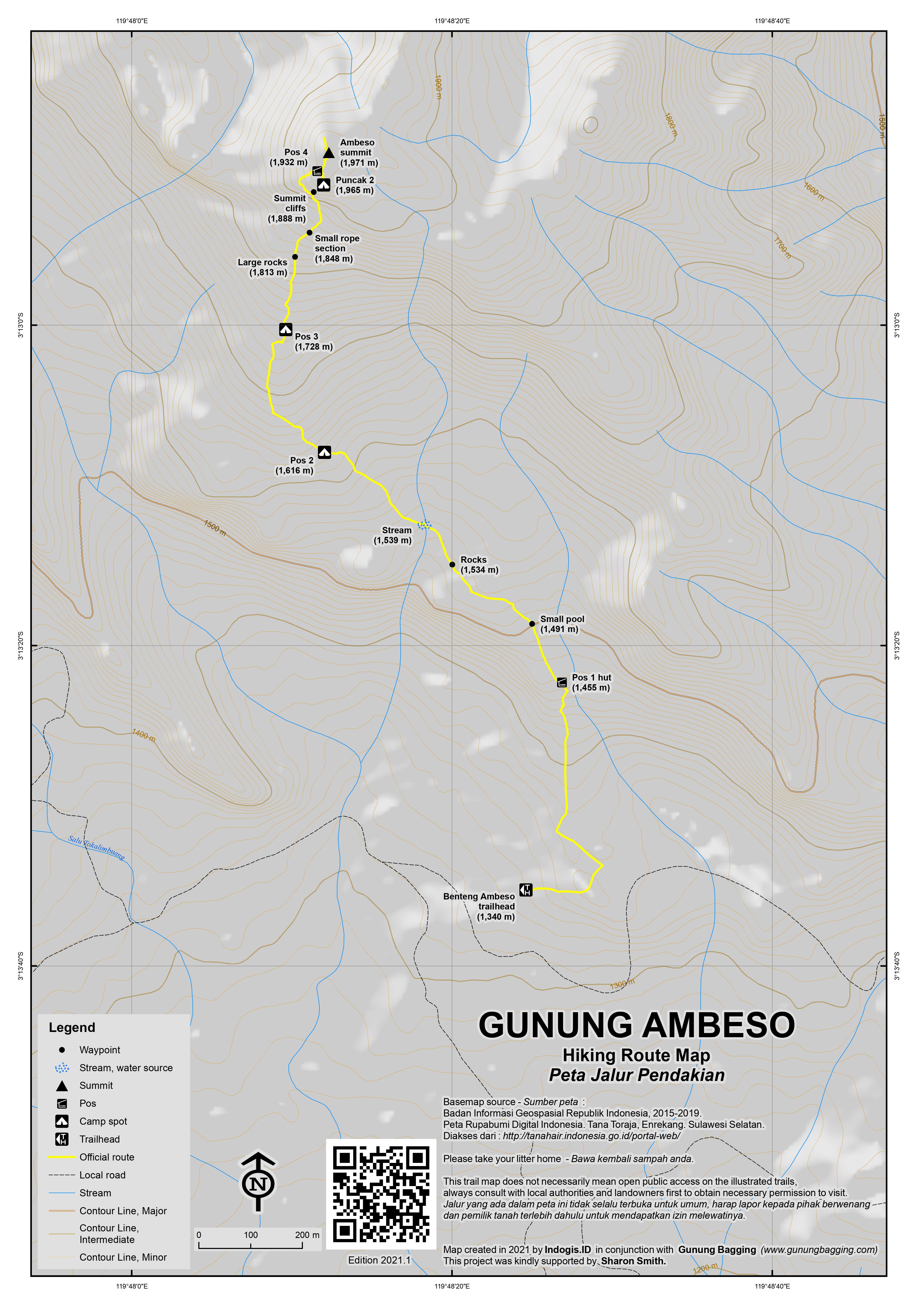
From the main road south of the airport, take a turning for Gandang Batu Silanan. Despite what map applications may suggest, it is best just to stay on the main asphalt road all the way to Benteng Ambeso rather than try any short cuts along narrow tracks. The scenery here is stunning, with karst ridges dominating the skyline in several directions. Like many parts of Toraja, this place is renowned for its high quality coffee.
At an elevation of around 1,300m, you need to take an unsignposted right turn and an immediate left up to where the road turns into a stone track. Motorbikes can be parked here at an elevation of around 1,340m. Follow the stone track up to a junction and take a left (1,369m). Soon afterwards, take a right behind a large wooden house (1,379m) which is ultimately the proper trailhead but has no signs.
Follow this path through coffee plantations before reaching a small wooden hut (1,455m). This is assumed to be Pos 1. Beyond the hut is a small pool of water (1,491m). Local hikers have tied bits of blue and green plastic to branches which help with navigation. Next is a rocky area (1,534m), which looks like an accidental walled garden of some sort. The views here to hills on the other side of the valley are great.
A small stream with a water pipe (1,539m) is the only place to top up water bottles, but given the shortness of the trek it is far from essential. Beyond the water pipe is Pos 2 (1,616m), at which point the trail has already entered proper forest. Pos 2 is a small, flat spot with enough space for a couple of small tents. Pos 3 (1,728m) is similar to Pos 2 in every respect.
Beyond Pos 3, the terrain gets rockier with large boulders (1,813m) and then a very short rope section (1,848m) on a steep section of trail, which marks the end of the forest and the start of truly stunning scenery as you near the top. Do take real care, as there are some deep holes and crevasses which are not always easy to see between the rocks and vegetation.
The vertical summit cliffs to the north are now in plain sight, and they need traversing round to the left. Pos 4 (1,932m) is not suitable for camping at and is really just a minor trail junction between Puncak 1 (the true summit) and the lesser Puncak 2 (1,965m).
The true summit really does feel like a fortress, with what appear to be stone walls at the top. The view is staggering and in clear weather includes countless karst ridges, the Pango Pango hill-top viewpoint to the north-east above the town of Makale, and the Latimojong mountains in the distance to the south-east. Most hikers will be up here in under 2 hours, and the view is a superb reward for such a short hike.
The Indonesian Bakosurtanal map lists this peak as ‘Buntu Ambeso’ with an elevation of 1,949m but the American AMS map (which labels it as Bulu Ambeso – both Bulu and Buntu are local words for hill) and GPS devices are more accurate, with 1,971m meaning that it is indeed a Ribu rather than a Spesial! The peak just over 1 kilometre to the west is Buntu Sangbuah (1,866m) and the peak around 2 kilometres to the south-west is Buntu Kuku (1,910m).
After enjoying the amazing panorama at the true summit, some may wish to visit the lower top known as Puncak 2. This is not essential but is only a couple of minutes from the Pos 4 trail junction. If you decide to visit Puncak 2, you will probably need a hand on the first scramble. This is the trickiest bit on the trail and needs concentration.
Most hikers can be back down at the trailhead in 90 minutes or so.
Gunung Sesean (2,160m)
The most popular short trek in the Toraja region is Gunung or Buntu Sesean (2,160m). This ridge is located in Toraja Utara (North Toraja) just a few kilometres north of the town of Rantepao which is the real heart of Toraja.
The hike can easily be accomplished in half a day as the starting point near Batutumonga is at an elevation of around 1,425m, not far from the very interesting megalithic site called Bori Kalimbuang, one of Toraja’s countless essential visits. On the main village road there’s a sign for ‘Sesean 4KM’ and motorbikes can be taken a little further up and left at resident’s houses for a small parking fee.
From here, continue up the wide track as far as the end where there is a house where you register and pay Rp10,000 for a ticket (1,463m). From here, take a left up stone steps. There is a sign for Pos 1 (1,476m) next to a couple of wooden shelters. Continue to follow the stone steps and admire the view back down to the rice terraces of the Rantepao plains. At 1,615m, a lovely ridge is reached and ahead you can see the higher slopes of Sesean, and over to the south-west the various popular viewpoints on the Lolai ridge.
A large flat rock (1,647m) is a particularly good viewpoint. Sadly, beyond here the trail meets an unnecessarily wide and unsightly vehicle track (1,657m) on the left presumably approved by the authorities but not in keeping with the environment at all. Thankfully, this construction site track is left behind (1,715m) fairly soon after, as the trail continues to follow the mountain ridge on the right of the wide track. However, it is not immediately obvious where to leave the wide track so, as usual, a guide is very much recommended to prevent confusion.
In this area, high up the mountainside, you are likely to encounter farmers and their buffalo, and there is a small wooden shelter (1,790m) where food for cattle is often left. Just beyond here the trail crosses a very small stream (1,800m) before reaching a junction where there are two tiny caves beneath overhanging boulder (1,810m). Take a left here and in just a moment you will be at a large flat area where local hikers camp at weekends. There is also a new wooden shelter.
For many hikers, this camping spot is the ‘top’ of Sesean, and though it is not by any means the highest point it is a good viewpoint if you can ignore the vehicle track scarring the landscape on the western side! Most hikers will have reached this point in 90 minutes or so.
It is recommended to continue higher up the mountain for another 20 or 30 minutes. The first interesting spot is a mini summit with a large stone on it (1,877m). This is a grand viewpoint. The trail then drops down a little way to a col before leading up to what from this angle looks to be the rocky knoll summit of the mountain. Near the col is a forestry map sign next to a large boulder (1,883m).
The trail enters mossy forest (1,914m) before leading steeply up to a mini ridge (1,980m) where the trail emerges from the forest behind the rocky knoll. Take a left on the ridge and follow the trail for just a few minutes to a large rock where there is a sign for Puncak Sesean 2,100m. Be very careful on this rock, because on the other side is an immense vertical drop! Despite what the sign says, this spot is around 2,013m high. However, it is a very worthwhile point to reach.
Beyond this sign summit is a higher top, just two minutes away but less people venture there as it looks a little dangerous to access. In actual fact, the Sesean ridge itself has two higher tops. The higher southern peak at 2,160m is still over 1 kilometre from the sign summit (2,013m). Further on is a northern top at 2,142m around 1.5 kilometres further north beyond a col at 2,055m according to the Bakosurtanal map. However it is not likely that either of these are visited regularly.
Most hikers can be back down in Batutumonga from the sign summit (2,013m) in less than 90 minutes. There is a very pleasant cafe overlooking the rice terraces and hills towards Rantepao.
Bagging information by Dan Quinn (April 2021)
For a high quality PDF version of this and other trail maps, please download from our Trail Maps page.
Practicalities
- Getting there: Makale is the nearest town on the main road between Enrekang and Rantepao and is about 1 hours from the trailhead. The new Toraja airport (Buntu Kunik) is just 30 minutes from Makale and in April 2021 has flights from Makassar most days of the week (Citilink and Wings). From Rantepao to the trailhead would take between 90 minutes and 2 hours.
- Guides and GPS Tracks: Want a PDF version for your phone? Looking for a guide? Need GPS tracks and waypoints? Gunung Ambeso information pack can be downloaded here.
- Trip planning assistance: Would you like Gunung Bagging to personally help you in arranging your whole trip? Please contact us here.
- Permits: Not currently required but it is best to take a local guide with you as route-finding at the start is a bit tricky.
- Water sources: There is a stream (1,539m) before Pos 2.
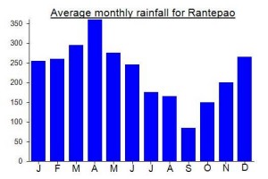
Local Average Monthly Rainfall (mm):
Location
Click on the blue arrow ![]() (top right) to see your current location on the map
(top right) to see your current location on the map
Just back from a five-day trip to Tana Toraja. Absolutely brilliant – probably within the top 5 regions in Indonesia that I would heartily recommend. And not only is Gunung Ambeso fairly easy and staggeringly beautiful, it is also a Ribu, having checked with my GPS and referred to the old AMS maps to double-check.
The new airport makes things much easier. It was officially opened a few weeks ago by Jokowi, and there are now several flights a week. The old airport, Pongtiku, whilst closer to Rantepao, could only handle very small aircraft due to the length of the runway. Buntu Kunik is fine for ATR 72s.
Ambeso can be seen on the left (west) on the descent and as you look down at the traditional Torajan houses it’s clear you are entering a very special area.
The airport doesn’t have any decent restaurants yet, but there is already a DAMRI minibus meeting flights and with seats at just Rp30,000 per person as far as Rantepao (or Makale if you prefer to get off there) it is great. The driver, Edy, can be contacted via WA on 085242636988.
Our Day 1 was just getting to Rantepao and getting some rest after a 1am start from Jakarta. Day 2 began with a short hike up Sesean, the most popular mountain hike in Toraja. Stunning area, but what a shame that the authorities have allowed a vehicle track up one side of the hill. The whole Sesean area is incredibly sceneic and has some of the best examples of traditional houses and standing stones. Note there are a few dogs milling around as is common across the Toraja region but I didn’t have any issues with them, especially having taken a guide.
After the hike we visited some of the really fascinating spots like Lemo and Londa – grave sites in cliffs, human skulls, tau-tau effigies. Sadly as covid has totally destroyed the international tourist trade, most of the nicer looking restaurants in Rantepao appear to have closed down, at least temporarily.
Note that many of the banks and schools and the Rantepao post office are constructed with the tongkonan traditional house frontage. Absolutely brilliant artistry.
After a second night in Rantepao, a morning trip to Lolai hill-top viewpoint, a visit to the museum, and a hike up Buntu Singki (the hill on the outskirts of town with a cross at the top – only 15 minutes to the top) we headed to Makale for two nights.
Makale is perhaps a little less interesting that Rantepao but there is what is allegedly the largest Jesus Christ statue in the world at 40 metres or so. Another must-see, if only for the viewpoint. At present, the road is blockaded, and you must take an ojek Rp10k each way to the statue itself. It would be good if this money is providing locals with much needed income, but is it as simple as that or is this cash all handed over to someone else at the end of the day?
The next day was Ambeso. My original guide could not be contacted, so my Sesean guide came down for it, and despite never having hiked it before we managed well with a combination of map applications, my GPS, and asking a couple of locals. The hardest bit is finding the trail behind the house where there are no signs. You will probably need to ask!
As I wrote above, the scenery is stunning. Ambeso is better than Sesean, yet almost completely unknown except by local student hiking clubs. Once back down, we called off at a warung in the village for some ballo(k), which is the local Toraja palm wine. Bitter, citrusy flavour. A small water bottle full (provide your own empty bottle) is just Rp10,000.
If you are staying in the Makale area, an early morning trip up Pango-Pango hill (1,700m) is apparently well worth it for the views – a bit like a higher alternative to Rantepao’s Lolai ‘negeri di atas awan’ (land above the clouds).
I could go into more detail regarding the local culture, but there is simply so much of interest with regard to the architecture and belief systems that many many books have been written on it over the years. Now that the new airport is operational, this fantastic region is a little more accessible (for those of us lucky enough to be ‘stuck’ in the country during the pandemic).
Well, yet another failure to get to this mountain in South Toraja!
After what has been an absolutely horrible year for almost everyone, a Sulawesi trip over the Xmas and New Year period was planned, many months ahead, with some optimism that it would be possible and that the corona situation would be a little more in control by the end of the year.
Within just a week or two of booking Lion cancelled the flight and didn’t give us any alternatives so I had to phone and get us moved to the Batik air flights instead! I had been waiting since August to do anything longer than a weekend trip, entirely because of my employer, a school, and despite working from home. No annual leave as a teacher (a serious downside of the profession) and due to the term dates nothing possible beyond a weekend trip between late August and…. December 24th, the first day of the end of year holidays, and hopelessly close to Christmas Day to the point that all staff are going to have trouble flying internationally or domestically, quite aside from the added issue of coronavirus.
Indonesian authorities made matters much worse by changing the domestic travel rules for the holiday period at the very last minute, and then failing to communicate them effectively. Indeed, they barely communicated them at all, perhaps preferring to create inconvenience for hundreds of thousands of people who quite rightly as human beings might want to visit relatives after months of enduring a deeply non-pleasurable existence. They appear to want to reduce corona transmission by making it hard to travel domestically with the newly-required health documents, despite having cancelled airport tax to encourage the purchase of tickets (!), but when you end up with masses of people queuing up to get the test done, or waiting hours in an environment in which social distancing is impossible, just to check in (seemingly not possible online anymore) then the health benefit becomes rather unclear.
On Dec 15th, word trickled out that rapid antibody tests were no longer sufficient, and that even to go to Bandung by bus or train you would, from Dec 18th need a rapid antigen, which very few had even heard of. Even Kereta Api, the train company, could not give any clear information, until after being bombarded with thousands of tweets and cancellations they eventually said they were just sticking to the old rules for the time being, until they received sufficient updated guidelines from the relevant authorities. Hardly confidence-inspiring. Like most people, I would prefer to have travelled outside of the busy season, but like for most people my job would simply not allow such flexibility.
Fast forward to Dec 22, and Kereta Api were now offering this quick antigen swab test at many stations (a queue of 1000 at Gambir apparently!) but the validity for travel in Java or out of and back into was just 3 days! Previously it was 14, which made a decent trip and return journey possible. By this time, my workplace had demanded that everyone do a PCR test in school on the last day of term – Dec 23rd, the same day we booked independently to get an antigen swab for our trip. The PCR result would not be available until Sat Dec 26th – far too late to be of much use to staff travelling over the holidays! So I ended up doing the mandatory workplace PCR and then a rapid antigen the same morning. 2 nasal swabs for one day is quite enough.
We headed off to the airport at 10pm on the 23rd, and despite the roads being fairly normal, the queues at the airport were horrendous, even approaching midnight, and barely moving. No faster check-in line for Batik ‘tanpa bagasi / without baggage’ so we just stood there waiting, in an environment where social distancing is impossible. Apparently a group of Papuans ahead of us had been ordered to write a letter of apology to the airport after getting angry because of the new travel rules which were so poorly communicated to those travelling. This was causing an extra delay. Much could be said about this incident.
Our flight, due to take off at 0130, was listed on the information screen as departing at 0000. Quite a worry. These Soekarno Hatta information screens ought really to be called misinformation screens, given how inaccurate the information actually is. Whoever is in charge of this is doing a very bad job of it, but whoever you complain to just blames someone else. Very few members of staff to ask, aside from waiting another hour or so to actually get to the front of the queue. I asked a security guy but was just told to queue up and ask Batik. Finally I found a Batik representative. He checked and said it was indeed 0130 and that the screen was ‘error’. Yes, like on most days then. Why do you people not fix the damn information? Occasionally check-in staff shout out for certain flights (last call) but even for Indonesians it is almost impossible to hear what they are shouting if you are near the back of the queue.
We had been checking for the latest information online but even those living in Sulawesi in the queue could not tell us how many days the test was valid for out there, something essential to know as we were planning on multiple destinations. It was already likely that we would need a second antigen test to be allowed back in to Java (!) but beyond that, for travel within Sulawesi it was not clear. Old rules of 14 days (from the antibody test era which finished about 7 days ago) were apparently still being implemented, but with rocketing covid rates in Makassar and Toraja, tourist sites were being closed, no celebrations were to be permitted (as in most countries worldwide) and Lampung province over in Sumatra had seemingly just implemented the 3-day only validity rule, same as all of Java (big difference from 14 days!) Perhaps Makassar would be next.
At the best of times travel can be unpleasant and stressful, but in Indonesia during corona as a foreigner, and with the almost traditional lack of clear and accurate information it is highly unpalatable. So we decided to come home instead and just have a quiet holiday period at home, rather than be stressed that we would get stranded in Makassar with anywhere interesting to visit closed to visitors or have to spend however much more on extra tests, new flight tickets and the like.
As an Englishman, I cannot complain as much as usual this week, as our government has shown themselves to be utterly inept with a prime minister who personally I would not trust to do a paper round, let alone run the country. The ‘macet’ with the lorries in Kent this week is worse than the macet in Indonesia!
Well, we at least made it as far as the airport! We did buy a very nice mango coconut thai tea drink before getting a taxi back home again! And at least our fridge is clean! But…. what a rubbish end to a rubbish year.
So, once again Ambeso is postponed. Let’s hope there is an end to this covid-era soon instead of the ongoing sacrificing of everyone’s lives and sanity, and that we can begin to enjoy the world of travel once again.
After the trouble with guides for Gandangdewata I still hoped to follow the second part of the planned itinerary from West Sulawesi to Tanah Toraja to hike Gunung Ambeso / Ambesu and then Buntu Puang. I had found a nice young chap called Ridwan (0823 4809 8714), a member of ART – Anak Rimba Toraja, a local hiking club. He told me it takes about 4 hours to hike to the top and the trailhead is 90 minutes by motorbike from the nearest town of Makale. He was happy to help and I was looking forward to it.
I had booked accommodation in Makale, but things didn’t go to plan. After my diversion to Samarinda, Derawan and Berau, I had planned to fly from Balikpapan to Mamuju (same 6am Wings Air flight as I had been due to fly on the previous week but had cancelled after the Gandangdewata guides decided to cancel!) Plan was one night at a shariah hotel, the closest accommodation to Balikpapan airport so I could walk there easily at 5am for the flight. This was the same hotel I had booked previous, non-refundable, but cheap. Anyway, I didn’t end up staying a second time (!) so the owner must think I’m a complete idiot.
Why didn’t I stay? Well, I had been searching for info on the bus timetable from Mamuju to Toraja, so I could explore Mamuju and West Sulawesi (my final province to visit) before heading to Toraja. It was immensely difficult, as was finding any accommodation in Mamuju other than D’Maleo (the most expensive one) that actually responded to Facebook or WhatsApp messages or provided proper contact details. Pretty hopeless. None except D’Maleo on Traveloka.
One of Ridwan’s friends, Andi in Mamuju, offered to help with transport information, and I asked him about Mamuju to Makale a good 2 weeks prior to the day of travel. He was keen for me to use a car and driver, presumably as he would make some profit from this, but I said I was alone and wanted bus or travel (shared car) only. Well, he didn’t help much but sounded vaguely confident there would be a bus. Finally the day before I was due to fly to Mamuju he sent me a message saying there is no transport to Toraja on 29th and I would have to go on 30th. Obviously no good as 30th was the day of the hike after which I had accommodation booked and paid for in Rantepao.
Eventually he got in touch with a travel company about a seat in a shared car for 28th (150,000 per person – fine) as I had asked for 2 weeks ago. They were full for the next couple of days. I asked him why he hadn’t given me their number when I asked him originally over 2 weeks ago. No proper answer. So, his help turned out to be the opposite of help. The alternative was car and driver which would be a ridiculous 1.7jt. Cheaper to fly to Makassar and then to Palopo and back down a little.
Whoever is responsible for tourism in West Sulawesi deserves some criticism too. There is no website and almost no information whatsoever, even for someone who speaks Indonesian and spends several hours asking around! If they want people to visit, they will need to do a hell of a lot more than this to make it easier. You can book bus tickets from Makassar to Toraja online quite easily. Going there from Mamuju is less popular, but if there was even a little initiative it could be a great route to use. At present, don’t bother – it’s easier to ignore West Sulawesi and simply use the normal Makassar to Toraja route.
I decided 1.7jt was ridiculous to have to pay to get to Toraja from Mamuju and was so sick of all the problems with Sulawesi (including lack of info for the final mountain Buntu Puang) that I decided to fly back to Jakarta from Balikpapan and get some partial refunds on whatever tickets I could. Andi said ‘Okay Mr Daniel’, perhaps relieved that he would not have to pretend to assist me any longer. When you spend half your holidays just trying to get basic info like bus timetables and transport options and are expected to pay millions of rupiah as a solo traveller then the hassle far outweighs any enjoyment. A real shame that I didn’t get to hike Ambeso / Ambesu with Ridwan….
Hopefully next time but via Makassar or Palopo. Again, best avoid Christian holidays around Toraja as people may be too busy to help – annoying as most tourists have to use public holidays for their trips and the Xmas one is one of the key breaks each year.