Facts
- Elevation: 2,635 m (8,645 ft)
- Prominence: 1,093 m
- Ribu category: Tinggi Sedang
- Province: Nanggroe Aceh Darussalam
- Google Earth: kml
- Rating:
- Other names: Previously listed as ‘Burniklieuteun’. Written as Klieten on the Bakosurtanal map.
Photos
Bagging It!
Bur ni Kelieten is the most significant mountain near Takengon and Danau Laut Tawar. The whole Gayo highlands area is famous for its coffee and the temperature here is slightly cooler than down at sea level in Aceh’s coastal towns. The hike to the top and back can be completed easily in two days and in good weather the views of Danau Laut Tawar and over to Bur ni Telong and Geureudong are sublime. Furthermore, near the top of the mountain is a large area of beautiful, jagged karst rocks.
This Ribu is not climbed as often as nearby Bur ni Telong but is more challenging and perhaps more rewarding trek as it feels rather more remote. The starting point is Desa Kejuruan Syiah (1,260m) which is on the road along the souther shores of Danau Laut Tawar and takes less than an hour to reach from Takengon. It may not be easy to find a local guide at the village, so best speak to a university hiking club from the region well in advance (Mapala Alaska from Bireuen are recommended).
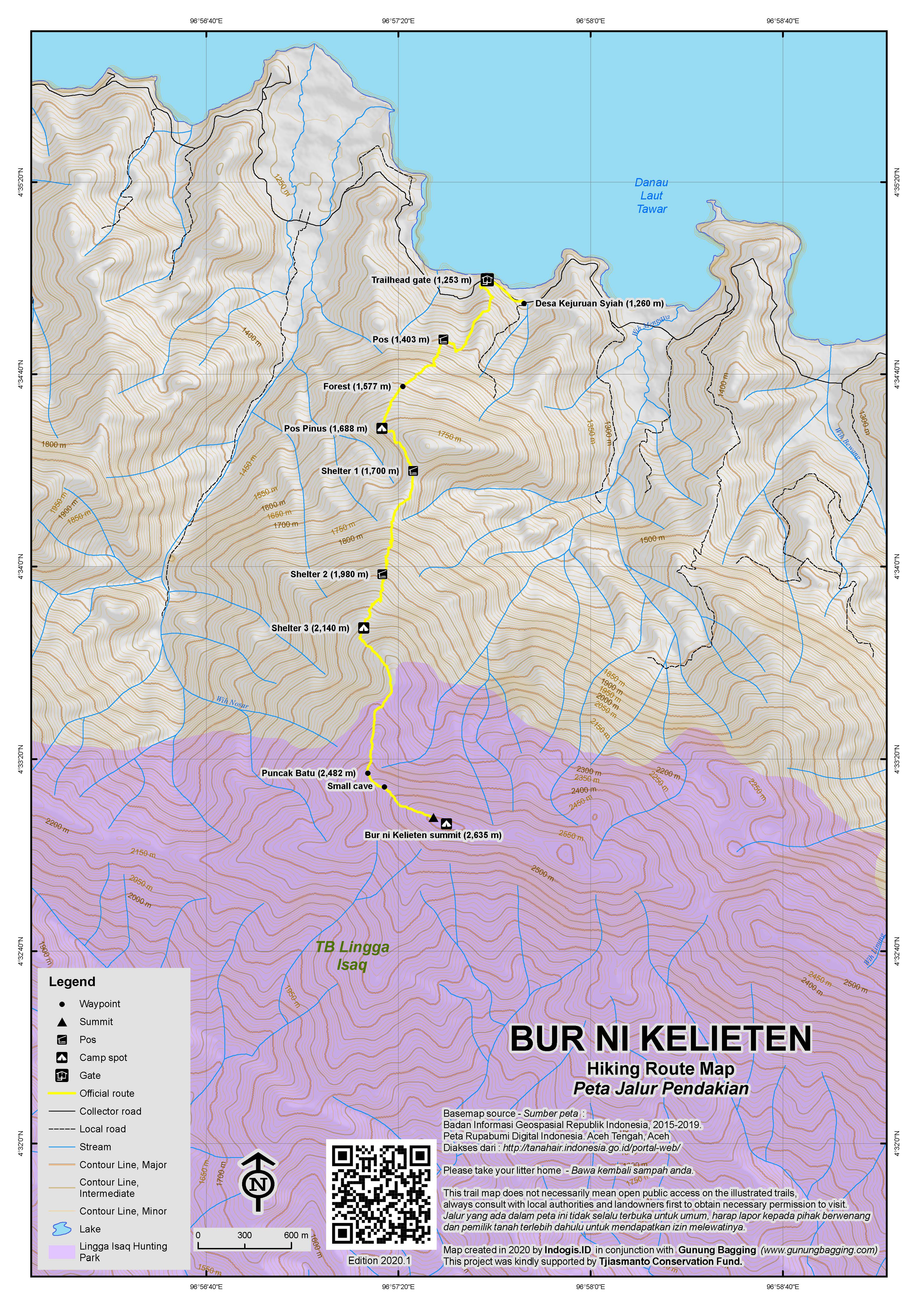
The trail at first is rather vague, heading up through bracken and pine trees, and despite the elevation this is a hot section of trail to begin with. Unlike Bur ni Telong, there are no signs however views back down to the lake are very pleasant indeed and you may also see eagles soaring above. Depending on how much gear you are carrying you should have reached denser (and cooler) forest at around 1,577m in about 60-90 minutes. Look out here for wild pigs (‘babi hutan’) as there are many here. Another 30 minutes and you will be at Pos Pinus (‘pine post’) at approximately 1,688m which has a very simple water collection device near some attractive rocks plus enough space for 2 or 3 tents. This is a decent enough spot to camp, but it really depends what time you set off and whether or not you are happy to set out very early the following morning to reach the summit.
Less than 10 minutes beyond Pos Pinus is an important junction where you must turn right. The trail drops down a bit here and is rather narrow. Shelter 1 (around 1,700m) is reached after about 25 minutes from Pos Pinus but as normal there is no actual shelter here and it is not as good a spot to camp as Pos Pinus. It is basically the obvious contour col on Google Maps (should you be using that app in addition to a GPS). Shelter 2 (1,980m) is reached in just under a further hour. Look out for enormous mountain frogs here!
Unsurprisingly, Shelter 3 (2,140m) is next and it should have taken you a total of 2 hours to get here from Pos Pinus. This is the best of the shelters for flat ground suitable for camping. The trail continues to climb sharply and soon you will find yourself on a pleasant moss forest ridge (2,280m) that undulates slightly. Eventually you will reach a small patch of mossy ground where one tent could fit (2,350m). There are partial views here to distant peaks but the best is very much yet to come. There are also pitcher plants from here all the way to the true summit (Nepenthes aff. lavicola, according to Alastair Robinson).
From this point on, the number of shapely rocks (presumably karst) on the trail gradually increase in number before you reach an open area with a tall flagpole and jagged karst rocks both large and small. This is Puncak Batu (‘rock peak’, 2,482m). The views to the right from here are brilliant on clear mornings, with the pyramid-like Bur ni Telong visible over the other side of Danau Laut Tawar below. Even when the weather is not so great it is incredibly atmospheric, with clouds drifting around forest ridges both near and far and the sharp karst rocks offering great photo opportunities from every angle. Sadly there is also a fair bit of litter from previous hiking groups. There is just about enough room between the rock outcrops to pitch a tent or two.
From Puncak Batu, the real peak is a further 500 metres away. This doesn’t sound like a lot but it actually takes about one hour. This terrain is very tough and occasionally dangerous, especially in wet weather, as you have to thread between knife-edge karst boulders that are very sharp indeed, and hop over deep chasms. Gloves very much recommended here. The scenery is pretty similar to the top of Gunung Mekongga in Southeast Sulawesi.
Finally you will reach a small clearing with a smaller flagpole and flag and a pile of rocks including the remants of a triangulation pillar. There are no views here but at around 2,635m this is the true summit of Bur ni Kelieten! Just beyond the summit is an area suitable for 3 or 4 tents. The Bakosurtanal gives a summit elevation of 2,638.6m.
It takes a similar time (one hour) to get back to Puncak Batu and a further 3 hours down to Pos Pinus. From there to the lake road is a further hour. When you add up all the times you can see that it woul technically be possibly to do this as a day-hike if you set out before first light. However, best weather for good views from Puncak Batu is likely to be early to mid-morning.
Bagging information by Dan Quinn (April 2018)
Trail Map

For a high quality PDF version of this and other trail maps, please download from our Trail Maps page.
Local Accommodation
Practicalities
- Getting there: The closest airport is Takengon’s Rembele airport which (in 2018) has a daily Wings Air flight from Medan. From here you are about 40 minutes from Takegon town from where it is a further 40 minutes to the trailhead at Desa Kejuruan Syiah.
- Guides and GPS Tracks: Want a PDF version for your phone? Looking for a guide? Need GPS tracks and waypoints? Bur ni Kelieten information pack can be downloaded here.
- Permits: Take a photocopy of your passport photo page or ID card andregister with the local village head. For a group of 3 hikers in 2018 it cost Rp50,000 total including leaving two motorbikes overnight.
- Water sources: None available on the trail except very small amounts from rainwater. Be sure to take more bottled water than you think you will need as the first part of the trail is surprisingly hot.
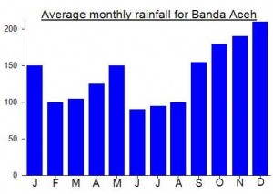
Local Average Monthly Rainfall (mm):


 (2 votes) Add your rating
Reached 70 (Ribus not years!) a few days ago on this pleasant mountain in Aceh. Thanks to the very knowledgeable Bang Dipa and Jepri from Mapala Alaska in Bireuen.
We’d just come down from Bur ni Telong and went straight from that peak to this one. The village head was not around so we spoke to him by phone and left an ID card and registration payment with the motorbikes. The village shop is not always open so buy your supplies in Takengon.
Despite starting at over 1250m this trail is absolutely roasting to begin with, especially for someone who is re-acclimatising from the UK climate and is carrying a big backpack with him! It took us 2 hours to reach Pos Pinus, but in cloudy or cooler conditions I can imagine 90 minutes is sufficient.
Puncak Batu is by far the highlight of this trek and you want to be there as soon after first light as possible. We were there around 8 or 9 ish, but there was already a fair bit of cloud. Nice views, but no distant panoramas or Bur ni Telong etc. Never mind… it was pleasant enough as it was.
Real care needed not to do yourself an inury on the narrow trail between Puncak Batu and the true summit. Lots of holes and painfully sharp rocks. Beautiful scenery though.
Had imagined that it would be easy to find a hotel room for the night back in Takengon but the first two were full up so I would definitely recommend booking in advance via email or phone. Plenty of options.
As for getting to Takengon’s Rembele airport from Takengon, there is apparently an airport shuttle bus which leaves every morning at 0720 from Paya Ilang terminal. I was up earlier than that, and wanted to get photos of Bur ni Telong from near the airport anyway, so I got a motorbike-becak thing for Rp150,000. Not cheap but it is over 40 minutes away and it was worth getting there early as the sun was coming up and starting to illuminate Bur ni Telong.
Next Aceh trip….. probably either Leuser or Peuet Sagoe.