
Facts
- Elevation: 1,448 m (4,751 ft)
- Prominence: 892 m
- Peak category:
 Spesial
 - Region:
 Peninsular Malaysia
 - Malaysian state: Perak
- Range: Banjaran Bintang
- Coordinates: 4.8591, 100.8154
- Rating:


 (2 votes) Add your rating
 Loading...
 - Other names: Formerly known as ‘Maxwell Hill’.
Photos


Bagging It!
Bukit Larut – or Maxwell Hill, as it was originally known – was founded by the British as a hill station at least as early as 1884 (1870 according to one local sign at the foot of the hill). It was primarily used as a retreat to avoid the hotter and unhealthier climate down below near sea level and also as an observation post for local tin-mining activity. It got its original name from the administrator of British Malaya, George Maxwell, in the early twentieth century and was officially renamed as Bukit Larut in 1979.
Unlike some other hills stations of Malaya such as Bukit Kutu, Bukit Larut was extensive and has also actually been well-preserved so many of the old buildings used as vacation houses are intact and even used as guesthouses sometimes. The buildings were renovated after local government discussions in 1997. Some of the trees that were planted here during the colonial era seem to have done very well over the decades and it makes for a very photogenic and fascinating area. Taiping is well-known locally as being the wettest place in Malaysia, receiving around 230 inches of rain per year, so best take a raincoat even if the weather forecast looks promising. Bukit Larut is also the location for the annual North Face Malaysia Mountain Trail Festival.
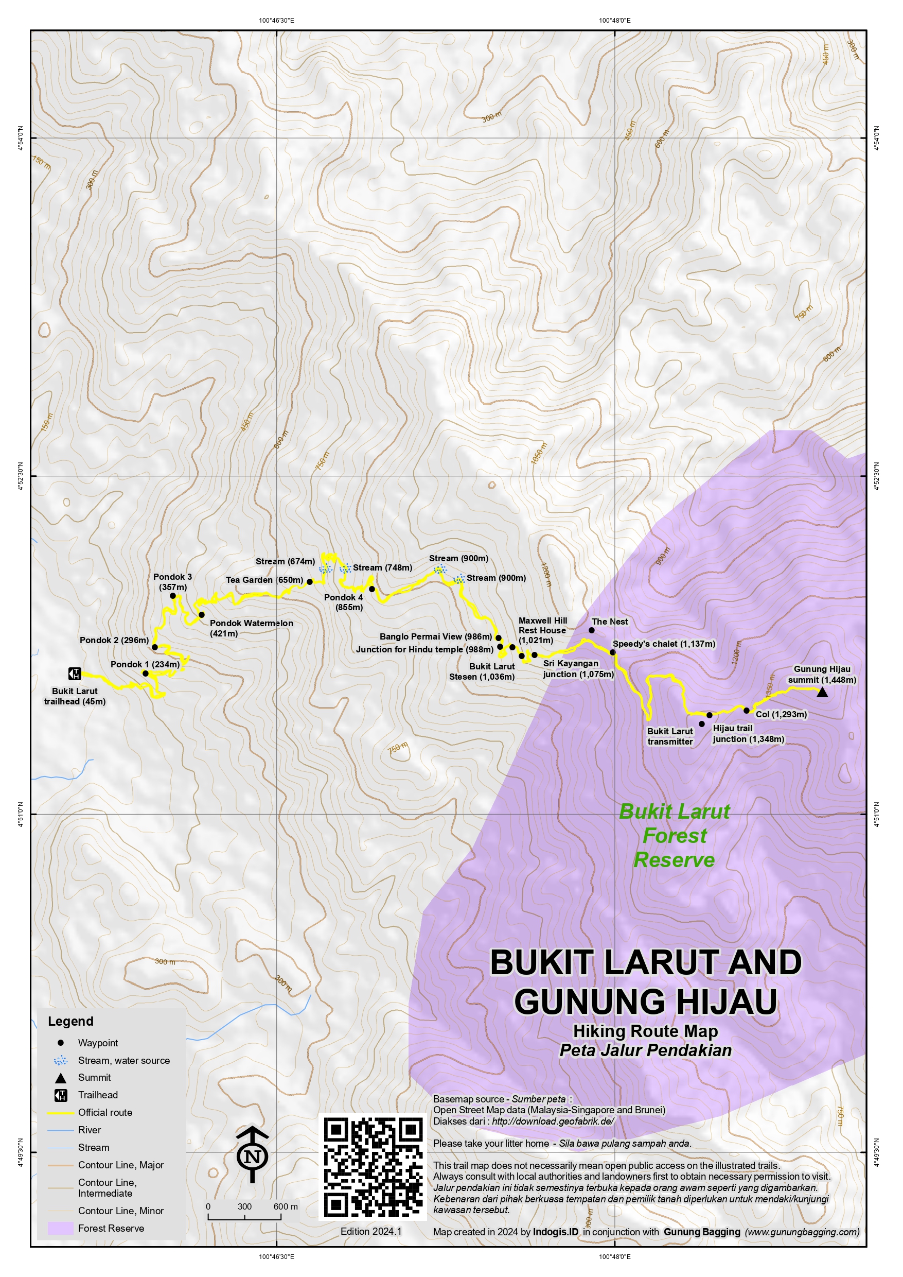
At present the 12-kilometre single-track road to the telecommunications towers beyond the centre of Bukit Larut is undergoing infrastructure improvement work but normally it is possible to pay for a seat in a regular timetabled jeep or 4WD from the base of the hill on the edge of Taiping as far as Bukit Larut ‘Stesen’ (1,036m). It is hoped that the road will be ready for vehicle use again in 2026 but until then visitors will have to walk all the way up from the start. There are some alternative paths in the forest lower down, but these are often overgrown due to lack of use and only cover part of the way to Bukit Larut, so it is actually easiest to simply follow the road, even if it is harder on the soles of your feet. The forest here is also notorious for the number of leeches it hosts!
The trailhead is at the edge of Taiping and is a popular place for local joggers, especially early in the morning when you may even find it difficult to park your car in the main parking area by the entrance and restaurant (45m). The road leads up via numerous Pondok, namely Pondok 1 (234m), Pondok 2 (296m), Pondok 3 (357m) and Pondok Watermelon (421m) which is a brightly-coloured rest area with a continually-running tap for joggers and hikers to fill their water bottles.
The next major landmark after Pondok Watermelon is Tea Garden (650m), which in 2023 is the farthest you are allowed to hike without a permit and guide. There is nothing left of the tea plantation now but the large building is impressive. The road crosses over a couple of streams (674m and 748m) before finally reaching Pondok 4 (855m). More streams follow (900m) before Banglo Permai View (986m). This is just prior to the junction (988m) for the old Hindu temple. The road then snakes round past the lookout (997m), Maxwell Hill Rest House (1,021m) and reaches Bukit Larut ‘Stesen’ (1,036m) which is the centre of what remains of Maxwell Hill and is also the point that the 4WDs usually drop people off and pick them up.
Beyond the centre of Bukit Larut is a junction (1,075m) for Sri Kayangan and then a collection of old rest houses including Speedy’s Chalet (1,137m). The track continues up the mountainside and eventually you will see the first telecommunications tower (1,316m) on the right. Shortly after that is the junction (1,348m) with the trail for Gunung Hijau. If you continue straight along the road you will simply meet a locked gate at the higher telecommunications tower. Taking a left, however, is where the jungle trail properly begins. It may only be a short distance from the access road to the peak of Gunung Hijau, and with only a fairly small descent in-between (down to 1,293m) but this place is notorious even after dry weather for the sheer number of leeches that are here!
Gunung Hijau summit is a humble grassy area and does not offer any incredible views. It is ultimately a bagger’s peak more than a tourist atrraction of its own. But given its close proximity to Bukit Larut it is a nice option for the adventurous.
Fast hikers should have made it to the top of Gunung Hijau in about 4-5 hours, but the descent is a little quicker at 3-4 hours. Once the jeeps are back in action you could feasibly hike from Bukit Larut to Gunung Hijau and back in around 3 hours but you will almost certainly still be required to have a permit and take an official guide with you.
Bagging information by Daniel Quinn (August 2023)
Trail Map
For a high quality PDF version of this and other trail maps, please download from our Trail Maps page.
Practicalities
-
- Getting there: For Malaysian domestic flights and flights within Southeast Asia, for example to Kuala Lumpur, we recommend Baolau. Very accessible, lying on the edge of Taiping which has a train station and regular buses to and from KL and Penang.
- Guides and GPS Tracks: Want a PDF version for your phone? Looking for a guide? Need GPS tracks and waypoints? Bukit Larut (Gunung Hijau) information pack can be downloaded here.
- Permits: You can register and pay for an e-Permit online from the Forestry Department of Malaysia website. A Perak guide is required for Gunung Hijau, but you can go as far as the Tea Garden on your own simply by registering on the day at the foot of the hill. When Bukit Larut re-opens to the jeeps then it will be a much easier trip.
- Water sources: The best spot is probably Pondok Watermelon (421m) where a tap is left running. The highest streams are at an elevation of around 900m, though you may be able to find a tap at Bukit Larut Stesen.
- We recommend Safety Wing as travel insurance for overseas travellers and tourists hiking up to elevations not exceeding 4500 metres.
Local Average Monthly Rainfall 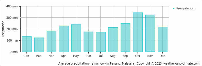
Location
Click on the blue arrow ![]() (top right) to see your current location on the map
(top right) to see your current location on the map
Well, this mountain is just fascinating from a historical perspective, even if the transport option is not available until, allegedly, 2026. Being part of the same mega-range or immense mountain chain as Gunung Bintang and Gunung Bubu, two of the worst leech mountains in Malaysia, it comes as no surprise that if you wander far off the asphalt you will delight the many leeches that live there and long for your blood!
It is actually possible to trek in the jungle instead of heading up the access road for at least the first couple of hours, but given the ferocity of the leeches, I would say ‘go ahead, but perhaps wear two pairs of leech socks’ or some sort of impermeable body suit’.
It is quite a trudge at first up the access road, and there is a fair bit of work going on with renovation, so expect to see nice forest and cement mixers and bored-looking construction workers! If you don’t have a guide you are only supposed to hike as far as the Tea Garden.
My guide Syaher was absolutely right with his predicted timing for us… it took precisely 8 hours return from ‘Kaki Bukit Larut’ to Hijau, maybe 4hr20min up and 3hr40min down. We saw monkeys, hornbills, huge centipedes, a dead snake, and lots of birdlife. Hijau itself was very underwhelming, and is certain only a bagger’s peak as there is no view possible. Many locals are scared of Gunung Hijau and claim it is haunted. Apparently this is because there is the grave of a westerner up there somewhere. Or so the story goes.
Once back down my feet were utterly knackered, not due to the length but rather the terrain, hard asphalt. Syaher tole me i should check out Gunung Semanggol nearby sometime, an easier and lower hill but with great views.
I then drove to Brinchang, Cameron Highlands. The plan had been Gunung Irau but Malaysian Forestry bureaucracy had basically put up a barrier to all of my attempts at getting permission to go for a walk in the forest there. The tourism and forestry agencies must be at real loggerheads these days as the former are out promoting hiking, as they should be, and the latter appear to view hikers with suspicion and make their lives difficult by requesting permit applications to be done weeks in advance which is just ridiculous and almost abusive.
My hire car was showing signs of being quite a bit dodgy by this stage, stalling for some unknown reason for the third time, no power. I thought it might be the battery, but later I found out differently! I was lucky to make it up to Cameron Highlands and sensible to arrive there on a weekday rather than suffer the traffic jams that are normal on weekends.
Perhaps I’ll be back to the Bukit Larut mountain range to check out Bukit Wray 1020m which is a former tin mine to the south. There is not much information on this but Cik Fizi is the man to ask.