Facts
- Elevation: 670 m (2,189 ft)
- Prominence: 400 m
- Ribu category: Spesial
- Province: Sumatera Selatan (South Sumatra)
- Google Earth: kml
- Rating:
- Other names:Serelo, Telunjuk
Photos
Bagging It!
Bukit Jempol is one of the best-known landmarks in Sumatra due to its steep and impressive summit cliffs and its location close to the main road near the town of Lahat. It is so well known and striking, in fact, that it has at least three names: Bukit Jempol (‘thumb hill’), Bukit Telunjuk (‘index finger hill’), and Bukit Serelo. The trek to the base of the summit cliffs is fairly easy (but slippery in the rainy season) and it makes a pleasant half-day hike.
South Sumatra has a reputation for being slightly more dangerous than most of Indonesia – apparently the risk of having something stolen or being held up on a public bus is a little higher, especially at night. For this reason, you might have trouble finding a local guide willing to climb in the early hours of the morning in time for sunrise near the top. Local nature lovers tend to stay one night in one of the huts over the shoulder of the mountain (see below for more information) even though the hike is a pretty short one.
If you have a driver, or someone who can look after your motorbikes or car, you can ask them to wait for you on the asphalt road that snakes around the base of the hill. Note that there are no signs whatsoever, so you will definitely need to ask local people for directions unless you have a GPS. From the road at the base of the hill you could be up and down in less than 3 hours and perhaps wanting more. Given that there is a fabulous tradition bridge crossing the wide Lematang River between the main road and the hill it is recommended that you add an extra couple of kilometres of easy hiking on to your day and start at the village of Ulak Pandan (80m), which on the main road between Lahat and Muara Enim, less than 20km from Lahat (35 minutes or so by motorbike). You could leave your motorbike there if you take a local chap as your guide.
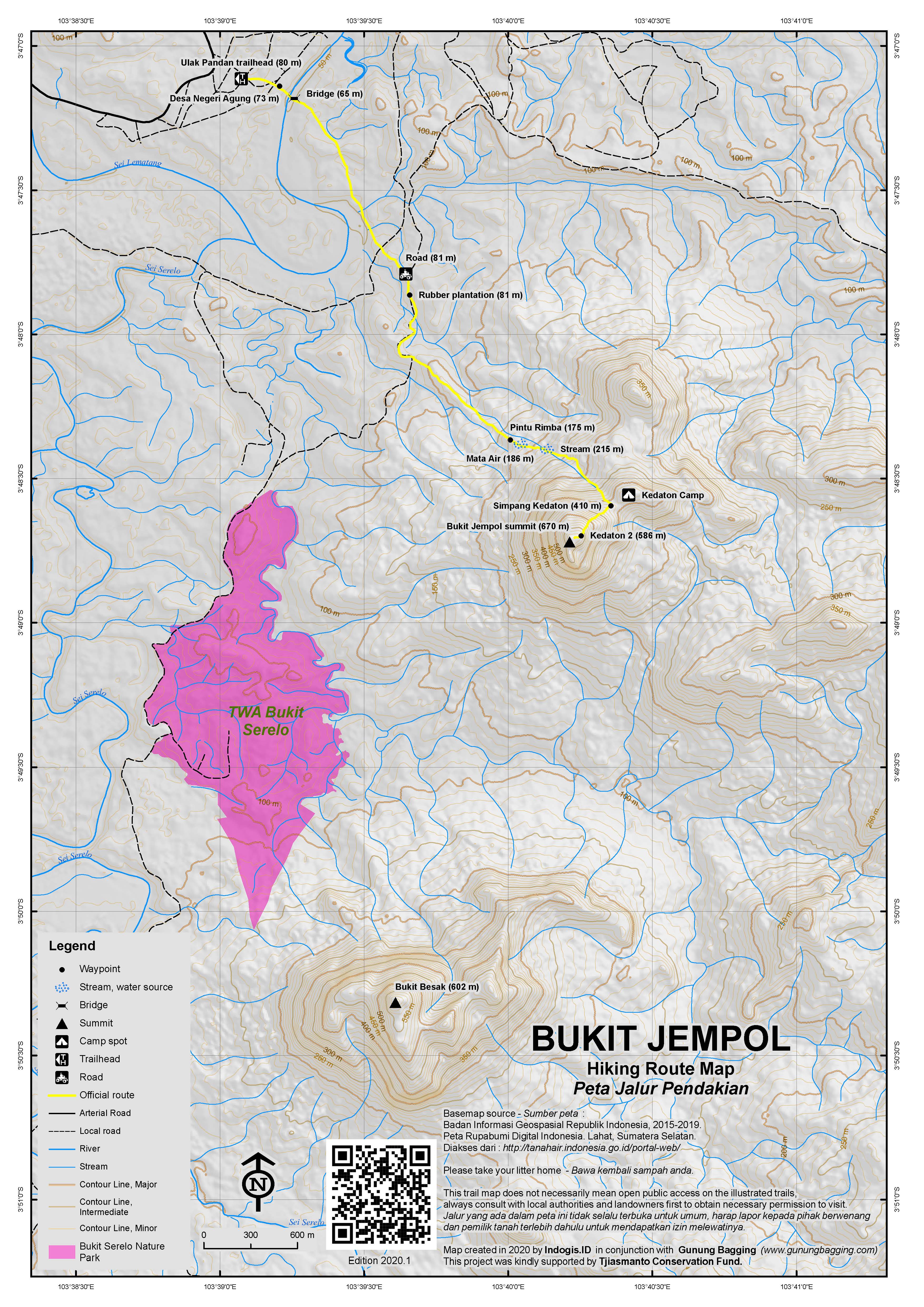
From Ulak Pandan, head towards the river and hill, passing through the neighbouring village of Negeri Agung (73m) before crossing the fabulous wooden bridge (if in doubt, just ask for ‘jembatan’) on foot. This is a super spot for taking photographs of the hill and its pointy summit. Once over the bridge, follow the small path down on the right that seems to lead along the side of the river. The trail then weaves through a couple of crop fields before reaching a wide farm track where there is a 4-way junction. Head straight across and up the hillside a little, past rubber plantations (81m), before reaching the tarmac/asphalt road which you then follow for 10 or 15 minutes as it winds its way up to a sharp bend to the right (100m) where you leave the road (on the left) and go straight up the track towards the shoulder of the hill. This is the point where you could leave your bikes/car with a reliable watcher if you want an ever shorter hike (see GPS tracks page for waypoints).
The path climbs steadily up the hillside, into forest (175m), and in a short time you will be at the water source (‘mata air’) (186m) where a source of cold, clean water seems to be reliable. Mata Air 2 is just 3 minutes further up the trail, which begins to get steeper and slippery (if there has been rain recently). After crossing a small stream (215m), a minor cliff face on the right side of the trail is reached. From this point you should check your boot for leeches – especially tiny ones which are difficult to detect at first. There are also quite a few mosquitoes.
The next major point on the hike is when you reach the shoulder of Bukit Jempol at the col separating it from a little grassy knoll to the east. This spot is known as Simpang Kedaton (410m) and is an important junction on the hill. As mentioned above, some local hikers like to camp on the hill. The spot they tend to choose is down the trail over the other side of the col (heading straight on) where there appears to be a small hut or house. For those just doing a day-hike, take a right here and up the increasingly steep and potentially very slippery trail for just 15 minutes after which you will have reached a collection of smooth and graffiti-ed rocks (540m). This a lovely viewpoint over neighbouring hills and lower sections of the summit cliffs. Also below is a particularly meandering section of the Lematang River.
The trail continues for just another 5 minutes, as it weaves round some large stones (known as ‘Kedaton 2’) which appear from higher up as three jagged rocks (586m). Just metres away at an elevation of 600m is the end of the hiking trail for ordinary walkers and the beginning of some serious rock climbing. Reaching the highest point is almost impossible without ropes, although the rumour is that a handful of Indonesian rock-climbing enthusiasts have reached the top without ropes. Either way, it would take several days to make a careful ascent and descent over very challenging terrain. Apparently the rock is andesite. It is not known what the exact height of the hill is but an old US Army map suggests 670 metres which seems reasonable.
After enjoying the view, which is a little spoilt by mining activity, ordinary hikers can be back down at the road in just under an hour, and back down at the bridge near Negeri Agung and Ulak Pandan villages in less than two hours.
Bukit Besak
The nearby peak of Bukit Besak (602m), which is just 4 kilometres or so south of Bukit Jempol, is also a worthwhile short hike. The top can be reached in just over one hour, and the views north to Bukit Jempol are excellent.
Bagging information by Dan Quinn (December 2013)
Trail Map

For a high quality PDF version of this and other trail maps, please download from our Trail Maps page.
Local Accommodation
Practicalities
- Getting there: It is about 20 kilometres from the town of Lahat to the foot of the hill. To reach Lahat, there are lots of buses, but it is perhaps best to take the executive class night train from Palembang (5-6 hours) or fly to Pagar Alam.
- Guides and GPS Tracks: Want a PDF version for your phone? Looking for a guide? Need GPS tracks and waypoints? Bukit Jempol information pack can be downloaded here.
- Permits: Not required at present (November 2013)
- Water sources: Available at ‘mata air’ and ‘mata air 2’, at an elevation of just under 200 metres up the hillside.
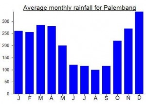
Local Average Monthly Rainfall (mm):


I went 26th Dec last year with my wife. That was her first hiking experience. Big thx to Dan for ur note. It helped me much, including a special warning about mosquitos!! Thx God my wife didnt forget to bring it although I rubbed it at the half of the trek.
We didnt see any difficult in our uptrek, only extra tired my wife suffered.
Few months before there was fire on the cliff, just before Simpang Kedaton (last place to camp before summit attack cmiiw). There got one victim, a junior high school girl, fell down and got burned. When we travel across that area, my wife briefly felt something strange. Maybe this is because her first exp being alone in the woods? Paranoid? Fire uproot the bamboo, made us hardly saw the path.
We faced a little prblem in downtrek. We got lost at the water source. Unfortunately (or magically?) we couldnt see the path after the water source. We went round and round, spending half an hour, while praying the best in heart. And finally we saw it, just for the 3rd time we came back to water source!!
we started our trek 10.50 at the minimarket before the bridge.
14.30 we arrived at base of the big wall.
15.30 we started to downtrek.
17.30 out of the woods, waiting for truck, car, or everything to pick 🙂
18.00 back to minimarket at Negeri Agung
Next time maybe I can bag it!!
For all, thx God for all ur blessings!
Just back from a very pleasant quick trip up to Bukit Jempol / Bukit Serelo. Flew to Palembang on Friday evening, got a taxi down to Palembang’s Kertapati train station (20km, Rp90,000 on meter, just under 50 minutes in the evening traffic) to catch the 9pm night train bound for Lubuk Linggau (getting off at Lahat). Train ticket was about Rp120,000 and thankfully it is now possibly to book executive class train tickets for services in Sumatra from Jakarta or elsewhere in the archipelago.
Lots of coal wagons at Kertapati station, seemingly no restaurants open in the evening despite two major train services. In true Sumatran Kereta Api style the train finally lurched off at 940pm, so 40 minutes late just getting started! Expected arrival time in Lahat was 01.48 but it didn’t pull in until 4am, over 2 hours late. Pretty pathetic, but much more comfortable than taking the bus.
From the station I got an ojek for Rp10,000 to Hotel Bukit Serelo, but you could walk it in 5 minutes. Lovely hotel, great staff, comfortable bed. One of the nicest hotels I’ve stayed in actually.
After a fair bit of rain overnight, the following morning the sky was blue and the sun was out so I called Gilang from a local Pecinta Alam (nature lovers’ group) and we set off for the mountain. There is one spot on the main road between Lahat and Muara Enim where a great view of the river Lematang and the hill can be seen. If you google the hill, most of the shots you’ll see will be taken from this location.
The blue skies stayed with us almost until we reached the base of the summit cliffs, at which point a rain cloud could be seen heading our way from the west. The low cloud gave the summit a new, imposing and dangerous look to it. We sat around in the rain hoping for it to stop, but after 30 minutes we could see even darker clouds heading our way. It is the rainy season after all. So we started our descent – sliding down on all fours on the higher sections due to how slippery and steep the muddy trail was. Thunder and lightning surrounded us but we made it back down safely and were over the fabulous bridge and having coffee with the locals at Ulak Pandan before too long.
I spent the late afternoon and evening back at the hotel, drying off, waiting for the night train back to Palembang, and eating my way through the restaurant menu.
hai dan, can we get motorcycle through that bridge? If we take a ride by motorcycle from Palembang, where can we put our motor last? Before or after the bridge?
Sorry Fandy – I just can’t remember! I’m sure you’ll be fine.