Facts
- Elevation: 1,571 m (5,154 ft)
- Prominence: 1,571 m
- Ribu category: Kurang Tinggi
- Province: Maluku Utara (North Moluccas)
- Google Earth: kml
- Rating:
- Other names: none
- Eruptions: 1564, 1673, 1885, 1911, 1917, 1926, 1949-52, 1981, 1987, 2007
Photos
Bagging It!
Gamkonora is the highest peak of Halmahera. Since its first recorded eruption in the 16th century, Gamkonora has typically produced small-to-moderate explosive eruptions. Its largest historical eruption, in 1673, was accompanied by tsunamis that inundated villages. The shifting of eruption centres, to the south, has produced an elongated series of summit craters along a N-S trending rift. (Smithsonian Global Volcanism Program) . The volcano last erupted in 2007.
The hike is highly recommended – it’s a pleasant “stroll” to the summit, a spectacular mountain for its extraordinary crater and towering walls on each side, open ridges below the summit, and fantastic views. The crater lies in a U-shaped valley between two very high walls on the eastern and western sides. From a view point at the northern end of the rift, one looks over a small lake and beyond to the craters, which were emitting enormous clouds of smoke every 40 minutes or so (September 2011). A short climb of about 200 ms up the eastern flank takes you to the vulcanology sensors and, two knolls beyond, to the summit. Altogether, it takes about 4-5 hours to reach the summit from the Volcanology Post and 3 hours to descend.
The climb starts just above sea level and passes through coconut, nutmeg and clove plantations before entering forest, in which pandanus palms predominate, higher up the mountain. A guide is essential to negotiate the tracks through the plantations and desirable for safety on the mountain. Staff at the Pos Pengamatan Gunung Api can assist in recommending a guide or alternatively call off at Desa Baru about 20 minutes before you reach the trailhead and ask for help.
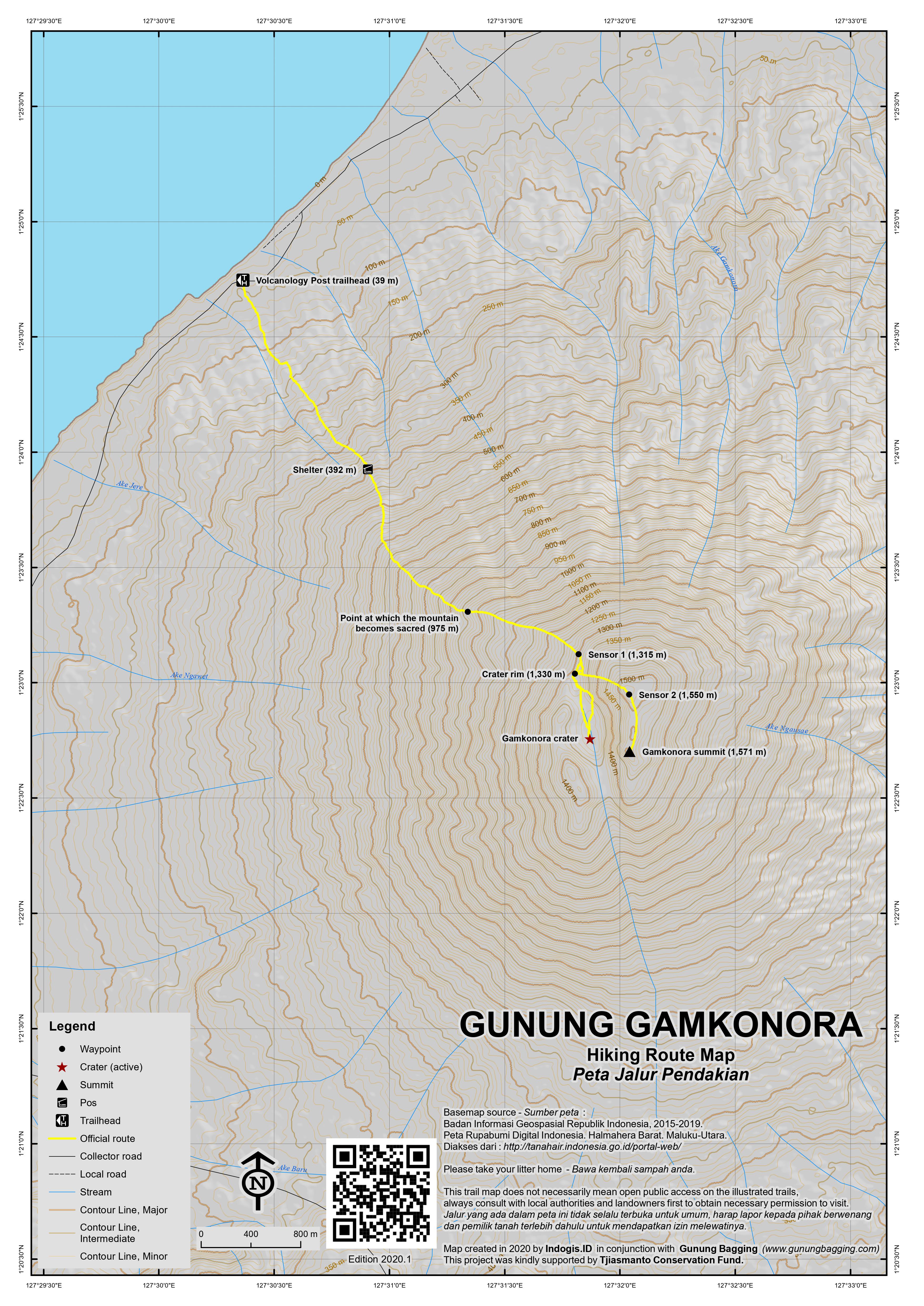
The ascent, about 8 kms, is a steady and enjoyable trek with very few obstacles or steep pitches. Like Gamalama and Kiematubu, Gamkonora has a miqat, a point at which the mountain becomes sacred with graves of nenek moyang (ancestors) on top. A small collection of coins lying on a rock just before entering the cane grass zone marks this point (at about 975m). Above the tree line, the track is on small rocks set in hard sand making for easy climbing to the summit.
The first point-of-interest is a view point (at about 1,330m) at the northern end of the rift overlooking the small lake and beyond to the craters with walls towering up on each side. After a short climb (about 300 metres) up the eastern flank, you reach the second vulcanology sensors (at about 1,550m) and, two knolls beyond, the summit.
The summit offers spectacular 360 degree views – north along the west coast of Halmahera with its many off-shore islands, north to neighbouring Gunung Ibu, north-east to Gunung Dukono behind Tobelo in the far distance, east and south-east to the high, non-volcanic mountains of the south-eastern branch of Halmahera, and south to Gunungs Gamalama, Kiematubu and Makian. A broad ridge, covered in low bracken and frequented by deer, runs down from the summit to the north.
Bagging information by Nick Hughes (September 2011)
Trail Map

For a high quality PDF version of this and other trail maps, please download from our Trail Maps page.
Local Accommodation
Practicalities
- Getting there: There are plenty of flights to Ternate island from Jakarta (usually via Manado and/or Makassar). From Ternate, take a speed boat from the Dufa-Dufa boat terminal just north of the airport, to Jailolo on mainland Halmahera. Arrange a hire car from Jailolo to Desa Gamsungi, Kecamatan Ibu, on the coast. Public transport is infrequent and unreliable.
- Guides and GPS Tracks: Want a PDF version for your phone? Looking for a guide? Need GPS tracks and waypoints? Gunung Gamkonora information pack can be downloaded here.
- Trip planning assistance: Would you like Gunung Bagging to personally help you in arranging your whole trip? Please contact us here.
- Permits: None required but take a photocopy of your passport photo page just incase. Check the eruptive status of Gunung Gamkonora at http://www.vsi.esdm.go.id/ Officials at the Pos Pengamatan Gunung Api, Gamsungi, are obliged to “close” the mountain to climbers when Stage 3 – Siaga (High Alert) – is reached.
- Water sources: None – take sufficient supplies with you.
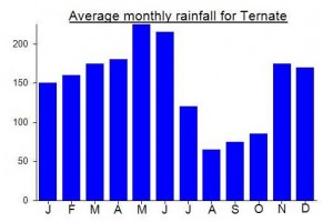
Local Average Monthly Rainfall (mm):


 (6 votes) Add your rating
What a brilliant volcano this is! Once you get beyond the elephant grass (?) and out into the open the views are fabulous. We took a driver from Jailolo (ask at Camar Cellular, next to Hotel Camar, call 081340330000) for about Rp500,000 for the day. It took us just under two hours to reach the trailhead, but we stopped off in the very friendly Desa Baru where we managed to locate a couple of friendly village lads willing to lead us up to the top. One of the them kept his leather jacket on for much of the hike! Us pale-skinned sorts were roasting hot, despite the hike being from the west and therefore avoiding having the early morning sun on your back which is one reason I struggled with the eastern approach the Todoko Ranu the day before. As Nick says, the trail start from just above sea level (approx 40m) so take plenty of water with you.
Once beyond the elephant grass the landscape reminded us of a typical hike in Scotland! Except for the volcanic crater and smoke of course. It took us 4 hours to reach the rim – and what a view that is. A small lake at the northern end and the active smoke hole further south belching smoke up the western cliffs. Thankfully the summit is on the eastern side, though you may still have a bit of sulphur in the air to contend with.
GPS reading at the summit was just 1571m. At first I attributed this to the crumbling nature of the cliffs (take care on the very edge). There are quite a few unusual butterflies and insects (including parasitic wasps) flying around that I have not yet been able to properly identify.
Vulcanology reports suggest that there is increased activity (tremors etc) this year so asking for help at the Vulcanology Post itself (just metres from the trailhead) may just mean that they dissuade you from climbing. That said, be sure to ask advice incase it really is dangerous. Alas the vulcanology website is not working at present for some reason.
All in all, a delightful hike. Very gentle gradient for much of the trail. One of the finest in Eastern Indonesia.
Pingback: Mount Gamkonora Shoots Ash to 10,000 Feet. | Chaos Sweeps Away the World We Know! The Disaster, current events & Catastrophe Blog. Forecasts for 2012 to 2020. Read tomorrows news today! Plus current economic, commodities, stock indices and financial n
Under Accomodation above, it is written: “Accommodation is available at Pos Pengamatan Gunung Api (Vulcanology Post)…”
It would be more correct to say: “The vulcanology staff at Desa Gamsungi welcome overnight visitors, if they do not have official visitors at the time.” That is, they are under no obligation to provide tourists with accomodation. So it is best to try to contact them in advance.
SMS Vulcanologist Pak Taufan 0857 56077 077 or try to pass a message via Driver Pak Idham 0852 4036 9730.
Some extra info from Nick for both Gamkonora and Ibu….
“It is virtually impossible to contact the Vulcanology Post and Desa Duono by hand phone in advance because of limited coverage. We agreed that the best way to contact these places was via our driver, Idham, who can pass messages on. Idham is an excellent, seemingly reliable driver, comes from Kecamatan Ibu, and now knows the logistics for climbing Ggs Gamkonora and Ibu well. His HP is 0852 4036 9730.”