
Facts
- Elevation: 1,249 m (4,098 ft)
- Prominence: 890 m
- Peak category:
 Spesial
 - Province:
 Jawa Timur (East Java)
 - Coordinates: -7.7241, 113.8465
- Rating:


 (5 votes) Add your rating
 Loading...
 - Other names: Known locally as Gunung Putri (Princess Mountain) and Gunung Agung
Photos


Bagging It!
Gunung Ringgit is one of the most striking peaks in Java with an attractive collection of cliff faces and steep jungle slopes. Despite its low height, it must be climbed from near sea level at the northern coast of Pasir Putih. The highest peak of the range has apparently never been climbed and would require ropes and advanced rock climbing skills. However, a decent trail leads up to one of the less-high tops which provides an excellent viewpoint over the rest of the range and to the nearby ocean.
Gunung Ringgit has two other well-known names; Gunung Putri (‘Princess Mountain) because, according to local people, the range looks like the face of a young woman when seen from the (east) Situbondo side. It is also known as Gunung Agung to the many Muslim pilgrims who climb one-third of the way up the mountainside to a complex of graves where they pray for health and good fortune. The name ‘Agung’ is taken from the second-highest peak in the range.
The trail starts on the main north coast road at SD Klatakan Pecaron in the village of Pecaron (a few kilometres east of Pasir Putih and barely above sea level). The path is very clear and very wide all the way up to the Agung religious complex (315m), and follows a large water pipe all the way up the hillside. In less than an hour you will have reached the religious complex, the alleged resting place of an important, ancient Muslim nobleman from the Situbondo area, Raden Condro Kudumo. You will undoubtedly be welcomed into one of the buildings by Pak Haji (Pak Taufik) and offered some clove cigarettes and coffee. Tens, if not hundreds, of local people climb here on a daily basis and if you are non-Indonesian then expect to have lots of pleasant questions asked of you and many, many photographs taken! Also look out for the many monkeys that live around here and try to steal food from pilgrims.
Once Pak Haji has given his blessing and had a good chat with you he will let you onwards up the hillside towards the only accessible peak known as Gunung Suunan. There are some good views down to the the little Gunung Carron and the ocean just beyond the grave complex but be aware that there are no water sources beyond this point. You will soon reach a large flat area where hikers often rest for a while, having reached the beginning of the ridge (765m). Further up the trail are several steep, rocky sections with thin pieces of rope attached to them. One section even features a metal ladder to help you ascend what would be pretty difficult terrain otherwise. Take extra care here.
You will soon have reached a ridge where a few large rocks lie (‘Batu Ampar’, 936m). One is perfect for sitting on. The trail continues along the steep ridge and up several more challenging sections before culminating with a final roped section just below the top of Suunan (1,138m). There is a small cave and a grave at the top and views down over the steep cliffs are magnificent in fine weather. This is labelled Gunung Agung on the Bakosurtanal map with two peaks of 1,163m (west) and 1,156m (east) respectively.
There is no access further along westwards to the other peaks due to the steepness of the terrain and so the trail ends here. The highest peak (just 1,201m on the Bakosurtanal map) lies about 1.8 km away to the west and may be worth investigating from the Kukusan side to the southeast of the mountain.
Return the same way and have a leisurely chat with Pak Haji and the local pilgrims before wandering back down to the main road at Pecaron.
Bagging information by Dan Quinn (January 2013)
Trail Map
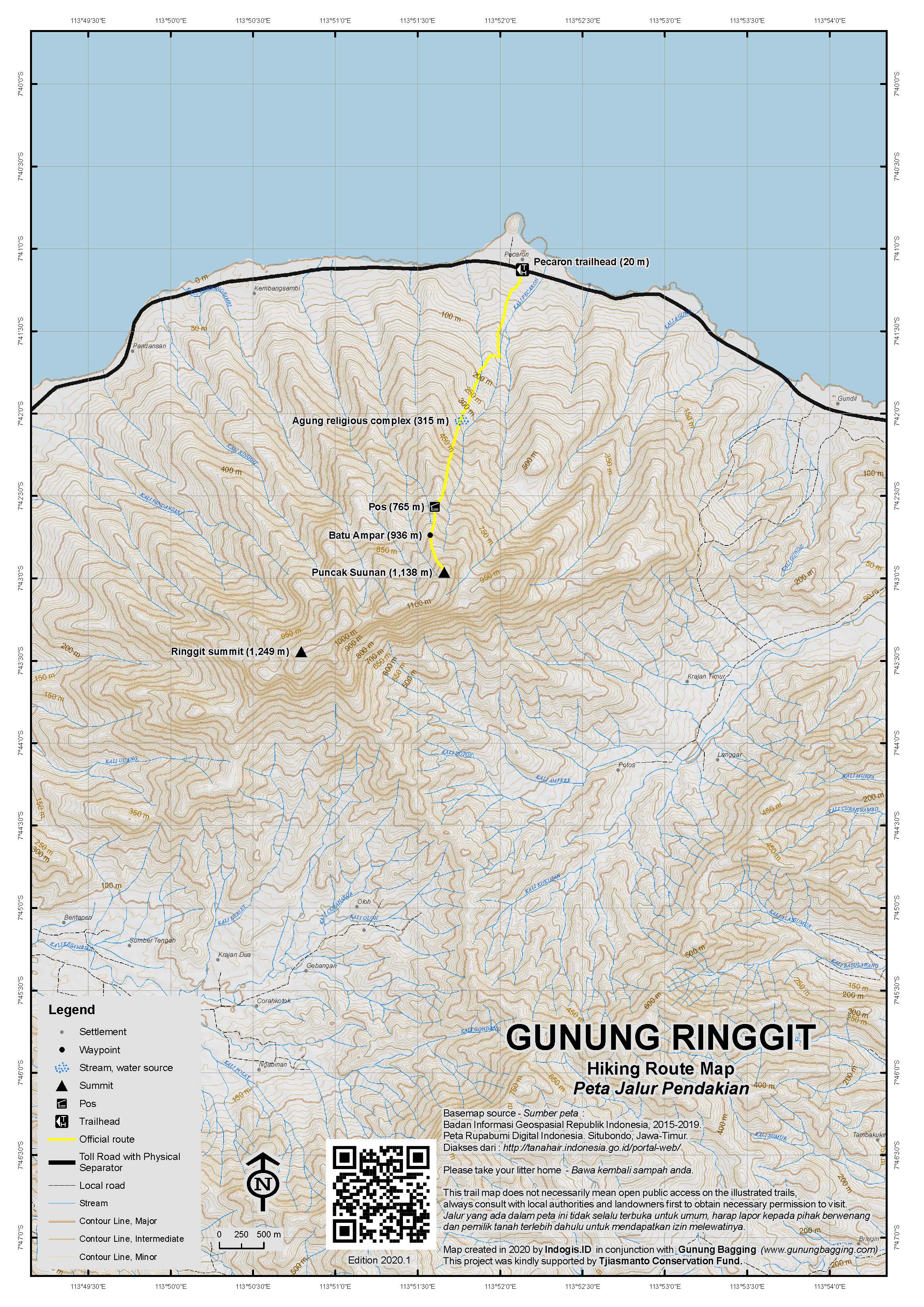
For a high quality PDF version of this and other trail maps, please download from our Trail Maps page.
Practicalities
- Getting there: For domestic flights from or to East Java, such as the airports in Surabaya, Malang and Banyuwangi, we recommend Baolau. Lots of public transport running along the northern coast road between Besuki and Situbondo. The closest airport is Banyuwangi (around 3-4 hours away).
- Guides and GPS Tracks: Want a PDF version for your phone? Looking for a guide? Need GPS tracks and waypoints? Gunung Ringgit information pack can be downloaded here.
- Trip planning assistance: Would you like Gunung Bagging to personally help you in arranging your whole trip? Please contact us here.
- Permits: Not required but take a photocopy of your passport photo page just incase.
- Water sources: Available as far as the Agung grave complex.
- Accommodation: Try the Booking.com map above or use this link to search for suitable hotels, homestays, resorts and apartments for your trip.
- We recommend Safety Wing as travel insurance for overseas travellers and tourists hiking up to elevations not exceeding 4500 metres.
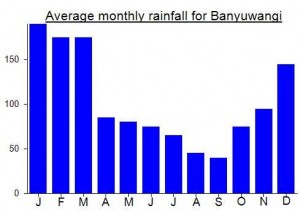
Local Average Monthly Rainfall (mm):
Location
Click on the blue arrow ![]() (top right) to see your current location on the map
(top right) to see your current location on the map
I visited this mountain on December 24th along with Adi, a local hiker from nearby Situbondo, who climbs this mountain at least once a month.
I flew to the tiny Banyuwangi airport from Surabaya (after having been in Bandung for the wedding of Gita and Gilles who met via this very website!). There is only very limited transport available at the Banyuwangi airport at the moment (presumably this will change as the airport gets larger to anticipate more travellers to Ijen and other places in Java’s Far East) so I was thankful to be offered a lift into Banyuwangi itself by a local Chinese family. There was a vast queue (perhaps 12km) of cars from the north waiting to board the ferry to Bali – some of whom must have had to wait at least 36 hours or so. Fortunately I was heading in the opposite direction but because of the few-and-far-between nature of the buses that day I simply ojeked my way round to Pasir Putih. All the losmens were full for the Xmas holidays so I continued on to the Nirwana Hotel near Paiton.
The mountain itself is incredibly striking and the jagged summit ridges and cliffs made me think of it as East Java’s answer to West Java’s Gunung Parang and it seemed unlikely that I would be able to reach the highest point of the range.
Myself and Adi set off on the trail at around 4am, reaching the pilgrimage complex just before first light. I was invited in as a genuine curiosity – the first ‘bule’ to ever visit – and tens of local pilgrims shook my hand and offered me cigarettes. Despite not being Muslim perhaps the locals thought having a foreigner here was an extra added good luck bonus- who knows.
Pak Haji proceeded to ask me about the age-old ‘rice vs bread’ debate and on finding out I was unmarried said I should find an attractive 18 year old from a nearby village. He then showed me some dvds of musical comedy made by a local Madurese chap called Martono (or similar).
Finally we were allowed to proceed up the hillside to the ‘summit’ grave. The weather was rather disappointing but the excitement grew as we clambered along the roped sections of the ridge. I am sure the Suunan summit would be a marvellous viewpoint in decent weather.
Back down again at the grave complex and a whole new group of local pilgrims had arrived to hang out, watch local comedy, pray and eat. After having my photograph taken by seemingly each and every one of them (‘Mr Bean visits an obscure local Islamic pilgrimage site’) I finally managed to escape back down to the coast and for some much needed rest before starting Argopuro the following day.
The sleeping volcano can suddently erruption.?