
Facts
- Elevation: 3,317 m (10,883 ft)
- Prominence: 851 m
- Peak category:
 Spesial
 - Province:
 Nanggroe Aceh Darussalam
 - Coordinates: 3.7477, 97.4791
- Rating:

 (6 votes) Add your rating
 Loading...
 - Other names: Written as ‘Kemili’ on the Bakosurtanal map.
Photos


Bagging It!
Do not attempt to climb any of the mountains in Aceh province that are over 3,000 meters if you do not have extra time on your hands. Without doubt, the province has some of the most poorly maintained roads in Indonesia. Distances are not measured in kilometres, but in hours that it takes to drive from one city to the other. It takes approximately 10 hours to travel 270km from Ketambe from Medan.
For the final 90 km the road runs through a wide valley that is protected on both sides by high mountain ranges that tower up to 3,000 metres. The range on the left is part of the Leuser National Park in which Gunung Kemiri as well as Gunung Leuser are located. The wide-open fertile valley is mostly flat and covered by large rice plantations, miles of cornfield. 25 km into the valley we pass the village of Karo, gateway to the Aceh province. Every traveller has to go past this checkpoint where heavily armed police officers inspect every vehicle. The exact purpose of this is uncertain.
Finally you will arrive in Ketambe where the Wisma Cinta Alam Guesthouse provides accommodation and help with arranging guides. After ten tiring hours on the road you will probably want to spend the night here. The following day, make an early morning departure with your guides to Gumpang which lies another 90 minutes along the road. On arrival in Gumpang hikers need to obtain a permit to enter the national park and to climb Gunung Kemiri at the local Military office. This can take some time but be patient and as long as you have photocopies of your passport then you shouldn’t have any problems.
The first two kilometres of the flat track from Gumpang lead through rice and cornfields and eventually over a hanging bridge across the large Simpang Kiri River that separates the valley. After the river crossing the path gradually starts to climb past new plantations. The fields are littered with skeletons of giant trees which were simply chopped down and then left to rot. The first campsite (1,271m) is reached after a comfortable 2 ½ hours. Often, because of all the formality and late departure from Gumpang, hikers spend the first night at this impressive campsite, which is surrounded by giant rain forest trees where orangutans live.
From here onwards the track is no longer clearly visible and is separated by falling trees that requires detours through very spiky bushes. After a slow but still very pleasant 2 hour scramble through very wet, moist and humid high altitude rain forest you will reach camp 2 (1,736m) which is a good spot to set up camp for the night. The campsite is small and offers just enough space for two tents. An additional bonus for spending the night here is the fact that only about 150 metres away is a terrific waterfall. Be very careful when having a shower in this crystal clear and very fresh mountain stream because the path to this perfectly hidden narrow river is very steep and most of the time extremely slippery.
Without doubt the section between camps 2 and 3 is the toughest part of the trek. However, after 45 minutes of slow progress an opening in the jungle offers spectacular views of the mountains surrounding, and is well worth a stop. Now the fun starts, as it gets really steep and very slow going – often seemingly vertical – across ,through, and under fallen trees, past oversized roots, through nasty thorny bushes up a track that, because of the daily downpours is very slippery. After a good 1½ hours, another most welcomed rest point is reached.
With an altitude close to 2,400 metres and only about 400 metres of climbing to go it becomes increasingly easier for the mind to conquer the last 1 ½ to 2 hours to the overnight camp site. As you get closer to the next stop, the forest gradually gets thinner allowing more sunshine into this densely forested surrounding. At the same time the steepest part of the seemingly endless struggle is behind and suddenly the going gets more comfortable and within a couple of hundred metres the next camp site is reached around lunch time.
There is plenty of space for four or five tents and the views are stunning. However, you could make it to the next camp site in an additional four hours. The first 200 metres leads through densely bushed and rather flat grounds, where tiger tracks are often spotted. The track then leads into a steep, deep valley that is once again covered by very dense rain forest. After only 15 minutes to the bottom of the valley and a short 20-metre detour there is a magnificent crystal clear spring that offers some the best wild drinking water in the country. An hour later, the next mountain top – just over 3000 metres – is reached and from here on the going gets very pleasant and breathtaking as every ridge and corner offers new and more exciting views of endless mountain ranges where one hikes from one top to the next.
An hour later you will reach camp 4 (3,173m). This spot offers plenty of space to accommodate at least six to eight tents. Being on top of the ridge, this site can be exposed to the elements and the very frequent weather changes. Although guides may want to camp here and then begin the descent the following morning, it is another five hours of good hiking to reach the true summit of Kemiri.
On the descent, which is the same route as the ascent, you will almost certainly need to spend one night camping. Camp 3 is a good place to have lunch and, unless you have a large group of hikers with you, Camp 2 is probably the best place to set up your tents for a final night on Kemiri’s slopes. From Camp 2 it is a pleasant four-hour downhill “struggle” back to Gumpang from where you can board your vehicle back to Medan.
Bagging information provided by Heinz von Holzen
Trail Map
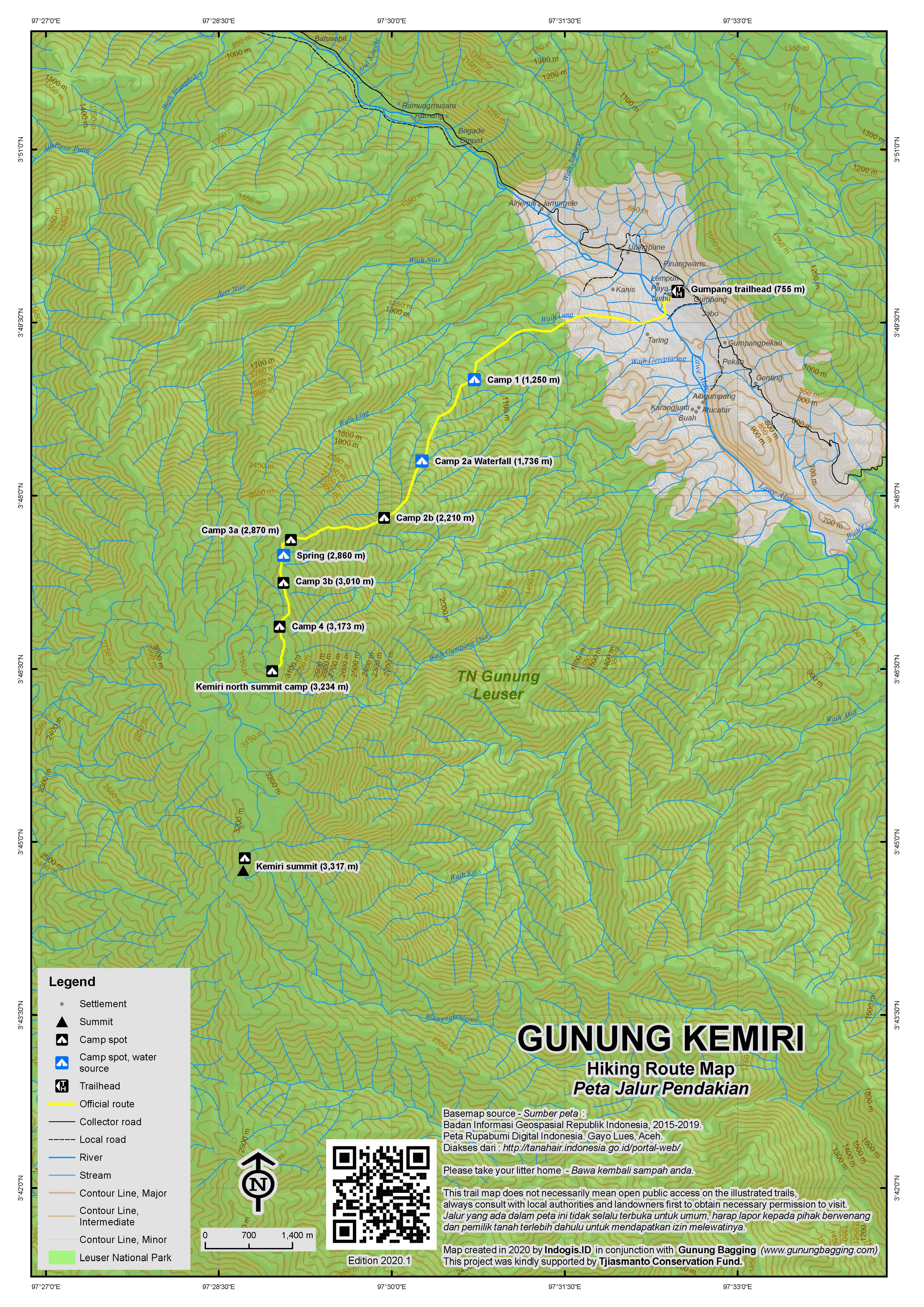
For a high quality PDF version of this and other trail maps, please download from our Trail Maps page.
Practicalities
- Getting there: It takes roughly 10 hours to reach the starting point from Medan by private car.
- Permits: Time consuming! On arrival in Gumpang hikers need to obtain a permit to enter the national park and to climb Gunung Kemiri at the local Military office.
- Water sources: Available in various places – your porters/guides will advise how much bottled water you will need to bring.
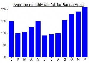
Local Average Monthly Rainfall (mm):
Location
Click on the blue arrow ![]() (top right) to see your current location on the map
(top right) to see your current location on the map
Origins and Meaning
‘Candlenut’ in Acehnese (Mark Durie, 2011). Candlenut (Aleurites Moluccana) is used in many Indonesian dishes and it is presumed that this mountain is, or was, home to a large number of candlenut trees.
Very interesting place to go!!. What is the best time (dry season or less rainfall period) to visit this mountain? I have been to Medan on early May last year to hike mountains around lake Toba area. It was a very wet trip. We rarely saw clear blue sky.