
Facts
- Elevation: 1,281 m (4,203 ft)
- Prominence: 1,259 m
- Ribu category:
 Kurang Tinggi
 - Province:
 Lampung
 - Coordinates: -5.7816, 105.6274
- Rating:

 (8 votes) Add your rating
 Loading...
 - World Ribus ID: 69125
Photos


Bagging It!
Gunung Rajabasa is the southernmost Ribu on the island of Sumatra and, as such, is easily accessible from Jakarta in a weekend. Because of its low height it is unfairly overlooked by many hiking clubs, but this is a positive thing because it means that the forest is still full of wildlife and there is little litter or noise or trail erosion here! Not yet anyway, so enjoy it while you can!
If you do not have your own transport, the best thing to do is take a DAMRI bus from Gambir railway station to Bandar Lampung. This includes the ferry crossing over the Sunda Strait. After the crossing, ask to be let off the bus near Kalianda near the southern tip of Sumatra. The mountain is mostly covered in vegetation, with cocoa and coffee dominating until forest proper from around 700m above sea level, but there are places where you can admire the view of Lampung’s southwest coast.
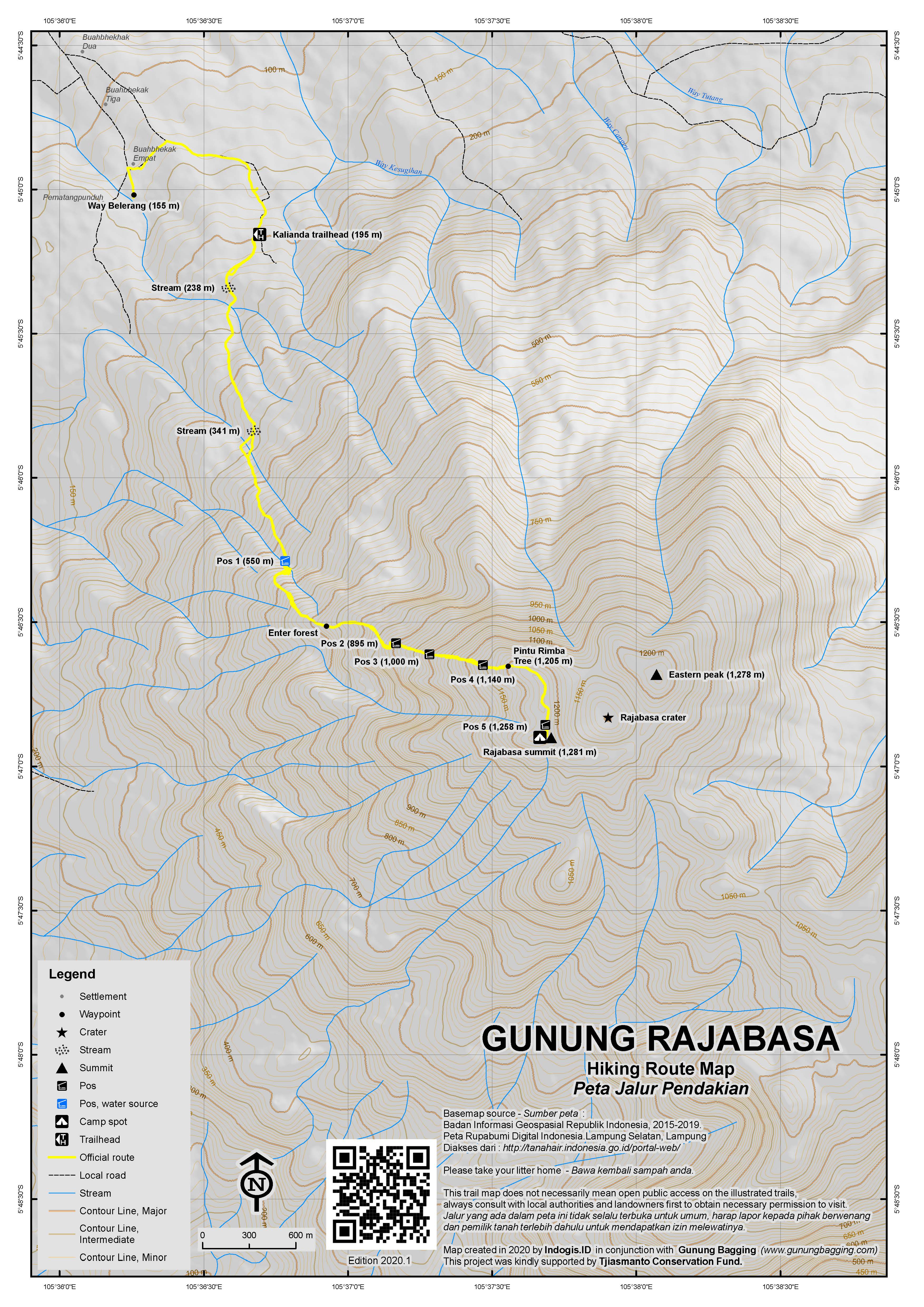
The mountain is very much an isolated one, and from the Trans-Sumatra highway it looks a great deal higher than it really is. However, since you have to start from under 200m above sea level, it is no less a hike than, say, Salak or Karang. It takes 6 or 7 hours up and down and the usual starting point is an unmarked spot (195m) on a minor road beyond Sumur Kumbang near Way Belerang (the natural hot water bathing pool, 155m) a couple of kilometres south of the town of Kalianda.
As is the case with many peaks of this size, there are many, many farm tracks on its lower slopes, so it is definitely advisable to find a local guide, or at least be prepared to ask for help from the many farmers who work on the slopes of the mountain. As long as you’re heading ‘up’, you’ll generally be ok, especially if you follow one of several small water pipes running up/down the hillside. Do be careful on the slippery cement paths on the lower slopes which might make life easier for farmers on motorbikes but are certainly not pleasant for hikers coming down.
There is one important left turning (at around 450m) near a small water collection tank on the cement path. Turn left off the cement and follow a less obvious path up the hillside. Before long you will cross a stream (the third and final stream crossing if you started at the usual trailhead) and find yourself at Pos 1 (550m). There is enough space for several tents here and good, clean water, but views are limited so it only makes sense to camp here if you started late in the day or the weather has turned bad. It should have taken you around 1 hour to reach Pos 1 from the trailhead.
Pos 2 (895m) is a further hour and is in proper forest (the forest begins at around 700m). Just prior to entering forest there are a few good views of the coastline south of Kalianda town, plus Sebuku and Sebesi islands. Watch out for small leeches once you have entered the forest as they are relatively common, especially during the rainy season. Pos 2 has a little bit of space for tents and it is probably the last spot before the summit for a good, flat place without excessive tree roots.
Pos 3 (1,000m) comes not long after and is a wider space but not flat and covered in tree roots. After another 30 minutes or so you will be at Pos 4 (1,140m), another less than ideal camping space. You are likely, however, to hear the call of many siamangs both near and distant and. There is also a great deal of birdlife onthis mountain. Pintu Rimba (1,205m) soon follows and it simply a natural arch formed by a tree trunk. Very photogenic.
As you near the summit you find that you are walking along the edge of a very old and dormant crater. Watch out down to the left as it is a steep drop. Apparently there was increased volcanic activity here during the latter part of the nineteenth century (perhaps something to do with nearby Krakatau?) but it is not known when Rajabasa last erupted. The crater is now a rarely-visited swampy area with a large boulder known as Batu Cukup that can apparently fit everyone from even the largest hiking group who visits. In 2018, the trail down to the crater was ‘closed’ or perhaps ‘no longer used and therefore overgrown’.
Pos 5 (1,258m) is a small spot with a medium-sized boulder. In very clear conditions early in the morning you can just about make out the industrial chimneys of Merak, the port at the western end of Java. From Pos 5 to the summit is only about 2 minutes! The summit itself (1,281.2m) is a small, pleasant, grassy area with a couple of signs and flags left by other hikers and, despite not being able to admire the view to the Krakatau islands due to the trees, a few other Lampung peaks further north and west are visible in good conditions and the southwest coastline of Lampung makes for a very fine view too.
The other, more forested peak to the east of the crater is just three metres below the true summit, according to Bakosurtanal, but the views are likely to be very limited indeed due to all the vegetation on top. If anyone does make it round them please take your GPS with you and get a reading.
It is best to return the same way and treat yourself to a soak in the natural hot water bathing pools at Way Belerang. Kalianda has some wonderful beaches to explore and transport back to Jakarta is rarely difficult to find from the main road.
Bagging information by Daniel Quinn (updated April 2018)
Trail Map
For a high quality PDF version of this and other trail maps, please download from our Trail Maps page.
Practicalities
- Getting there: DAMRI buses to Bandar Lampung depart morning and evening (7pm, 8pm and 10pm) from Jakarta’s Gambir railway station. These can only be booked in person within 10 days of departure or via WhatsApp and bank transfer the same week. Get off at Rumah Makan Siang Malam (where all the DAMRIs stop) or a little closer at the Kalianda junction (or ask for Rumah Makan Tiga Saudara IV). Hopefully you will have your guide waiting for you there if it is night time. You could also fly to Bandar Lampung and backtrack down to Kalianda but it may not save more than an hour or two.
- Guides and GPS Tracks: Want a PDF version for your phone? Looking for a guide? Need GPS tracks and waypoints? Gunung Rajabasa information pack can be downloaded here.
- Trip planning assistance: Would you like Gunung Bagging to personally help you in arranging your whole trip? Please contact us here.
- Permits: None required but take a photocopy of your passport photo page just incase.
- Water sources: Available at Pos 1 (550m) – but take sufficient supplies with you.
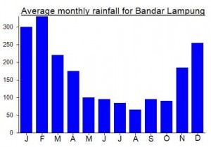
Local Average Monthly Rainfall (mm):
Location
Click on the blue arrow ![]() (top right) to see your current location on the map
(top right) to see your current location on the map
Origins and Meaning
‘Raja basah’ means ‘wet king’ in Indonesian! One Lampung resident explains that ‘raja’ also means ‘regal’ or ‘royal’. You might think that the ‘basa’ part could be due to the mountain receiving a considerable amount rain and cloud, however a more sensible explanation is that ‘basa’ is actually a contraction of ‘bahasa’ (language) and that the ‘Raja Bahasa’ (King of Language) was a historical local leader who successfully brought together different ethnic groups living in Lampung to work with each other together, united.
Last weekend, I climbed Rajabasa for the second time. The first time was way back in 2009, sufficiently long ago that I had forgotten much of the trek. Just the same as 9 years ago, I got a DAMRI bus from Gambir station on the Friday evening. You can probably just show up and get a seat, but with it being a weekend I thought I ought to get one in advance so I went there a couple of weeks earlier. Alas, they will only sell tickets within 10 days of departure, which makes terrible business sense as the price of the middle of the range bus (Rp205,000) is not much below the price of the very short flight to Bandar Lampung (as low as Rp300,000).
There is also a WhatsApp number 0813 9893 8316 and you can book a seat online within 7 days of departure if you have an Indonesian bank account. No website or proper online booking at the moment…. DAMRI’s bizarre motto is ‘berubah atau mati’ (change or die/ changing or death) but they really need to change a bit quicker and modernise to prevent being overtaken by more tech-savvy competitors.
We left at 7pm, reached Merak around 2240 (bad Friday night traffic in Jakarta, so getting a later bus might be a good idea) and then boarded a fairly empty boat. Took about 2 hours for the crossing to Bakauheni, including waiting time, and disembarkation time. No dangdut music on this particular boat, but there often is! It is quite pleasant with the warm Sunda Straits breeze gently blowing across you. At Bakauheni, there is a new toll road, but it only goes for a few kilometres before joining the normal one. Still, infrastructure progress is being made, slowly.
I had arranged to meet Reza, the ‘Rajabasa Ranger’, (082269333912) at Rumah Makan 3 Saudara IV near the Kalianda junction (about 40min from Bakuaheni). Do not confuse this Rumah Makan with the 3 Saudara II or any of the other Saudaras! Alas, the DAMRI checkpoint is still at the Rumah Makan Siang Malam about 7 km before the Kalianda junction. And despite everyone having had 2 hours on the boat to smoke and eat pop mie, the swines end up wandering about in this restaurant the middle of the night, smoking and eating more pop mie. So best either meet a guide here if you are meeting one, or else expect to be waiting up to half an hour for drivers and passengers to get back onboard!
The hike itself was very pleasant – a superb gradient, only steep in one or two places. There are several Pos now which I don’t recall from the first time around. We were up at the summit within 3 hours, perfect timing for first light. From Pos 5, just below the summit, I could make out the Java (Banten) coastline. The weather was a little cloudy, but the views very pleasant indeed.
Unlike all the peaks in Java which over the last decade have turned into litter-covered noisy villages, Rajabasa still does not see many hikers. Yet! It must be one of the quietest mountains that you can travel to by road/sea from Jakarta and back in a single weekend. Lots of animal life too.
Unfortunately the path down to the crater is either no longer used or non-existant now so we didn’t go down there to see Batu Cukup. Some locals call this crater ‘danau’ (lake) so it must fill up during the rainy season.
The peak on the other side of the crater looks higher from some perspectives. The maps all suggest 1281 or thereabouts as the Rajabasa summit height (my GPS gave 1282m at the usual summit) and one map I studied (see comment elsewhere on this page) suggested that the other, rarely-visited or inaccessible peak is 3 metres lower. It is difficult to tell as the inaccessible peak has trees growing on it and the normal peak just has grass, so obviously if these trees are ten metres tall or more then the peak is bound to look as tall if not taller. Would be great to hear from anyone who has visited both with a GPS, though I imagine I could be waiting a few decades for that!
We were back down in just over 2 hours and I walked round to Way Belerang and had a soak. These hot pools are only Rp10,000 to use and despite the toilets/changing areas being almost derelict are very much worth a visit. Even on weekends they seem quiet and you can get a kelapa muda for just Rp5,000.
I was expecting the very reasonably priced Wisma Belerang hotel to be very basic and was quite astounded to see how big it is. Like the pools, this place seemed very quiet even on a weekend, despite the obvious potential. I had a room on the top floor and was treated to an amazing sunset that night – the sky was on fire, and the fairly ordinary Gunung Pesawaran looked thoroughly exotic and glamorous.
I thoroughly recommend Wisma Belerang – great spot. Only issue is finding ojeks down into town. One of the staff members very nicely gave a me a lift down the first time and I arranged a pickup the following morning with an ojek guy from town (Rp10,000). I woke up late (as I had been hiking the previous night, but also… what a wonderful bed) and went out to check my ojek guy was there as arranged. Bleary-eyed, I spotted his numberplate down below and saw he was 5 minutes early. I quickly got ready and went down… by which time he had disappeared (or had I dreampt/imagined looking down on his bike?) It didn’t help that the boy on the desk was still asleep so I couldn’t be sure 100%. Anyway, as I was pissed off, he called a friend to take me to the main road where I waited for a bus towards Bakauheni.
It was still early, and it could well be that buses down reach this point heading south until 8am or so. I ended up getting an ojek down as the morning was clear and I wanted a few photos of Rajabasa from near the road down to Bakauheni. Rp50,000 was a good price I thought, but Pak Ojek decided to take me through his village to show me off to his family and friends (or was it really to get a second helmet?)
The boat ticket over to Merak is Rp15,000 (what a bargain) but we were stuck in a queue at the Merak side waiting to dock for about an hour. From Merak there are tons of buses heading to Jakarta for around Rp25,000, and you don’t need to get an ojek to the bus terminal as they pause at the port entrance. In actual fact, they pause pretty much everywhere. It’s like being on a very large angkot. EVentually you will get back to Kalideres or Kampung Rambutan (‘hairy village’!) or whichever terminal you are bound for!
Some may wonder whether it is sane to go straight from work on a Friday, over to Sumatra and climb a gunung in the middle of the night. I would say yes it is. Hiking Rajabasa during the day would mean a potentially much hotter trek and more likely hazy conditions at the top. Though you could climb it the following night (or take a daytime bus over).
Hi,
I’ve just climbed Gunung Rajabasa today and despite not offering great views from the summit, I think it is a great hike.
The upper half of the mountain is full of wildlife such birds, wild pigs and many siamangs which you can see quite close as they jump along the trees.
John, thanks a lot for your tips, they’ve been really helpful for me to find the right path, as I did the climb on my own and couldn’t get any track for the GPS.
I have logged the track and I have shared it through http://www.wikiloc.com. if anyone interested, it can be downloaded from that website.
If you turn left off the road that heads from Kalianda up to Way Belerang and head east for a kilometer you’ll reach the village of Sumur Kumbang (alt.174m), which is a better starting point than the hot springs itself.
I met up there with Dedi (HP: 085664655882), a local nature lover, and some Kalianda students who were planning a tour of the summit and crater.
If you the road straight up through Sumur Kumbang, branch right at the upper junction and then take a path on the right 50m further up beside a house, you’ll find a concrete path through a cocoa plantation. If you find a few people to ask, you should make it through the plantation without getting lost and after an hour or so you’ll reach a stream at 550m.
From there on there’s only one path, which climbs steeply but pleasantly through forest up to the west rim of the crater. We took just under 4 hours from Sumur Kumbang to the summit.
From the clearing 20 metres below the summit it’s possible to reach the crater. Double back to the near left corner of the clearing (far right corner if you’re coming back down from the summit) where there’s a narrow path down to a col. Turn left from here down into the overgrown crater, which is about 150m deep. In rain this path would be very slippery and in any case the crater is said to become a marsh/ lake in the rainy season.
In dry conditions, you can walk around the edge of the crater, climb up a path on the northeast flank and then continue around the rim to rejoin the main path at the northwest corner.
Rather than do this and descend by the same route, we headed down northeast from the lip of the crater along a hunter’s trail that leads down to a coffee plantation. This route offers a glimpse and a sniff of the sulphur-seeping gash on the mountain’s north slope. However, the trail down the ridge here is hard to follow, even in the plantation section!
Don’t settle for a quick splash in the hot pools at Way Belerang. Treat yourself to a long soak- with a Bintang from the Alfamart and some sulphurous soap you can buy on site! It’ll clear up your acne! (the sulphur that is, not the Bintang…)