
Facts
- Elevation: 2,211 m (7,254 ft)
- Prominence: 1,679 m
- Ribu category:
 Tinggi Sedang
 - Province:
 Jawa Barat (West Java)
 - Coordinates: -6.7161, 106.7336
- Rating:

 (27 votes) Add your rating
 Loading...
 - Other names: ᮌᮥᮔᮥᮀ ᮞᮜᮊ᮪
- Eruptions: 1698-99, 1780, 1902-03, 1919, 1935, 1938
- World Ribus ID: 69060
Photos


Bagging It!
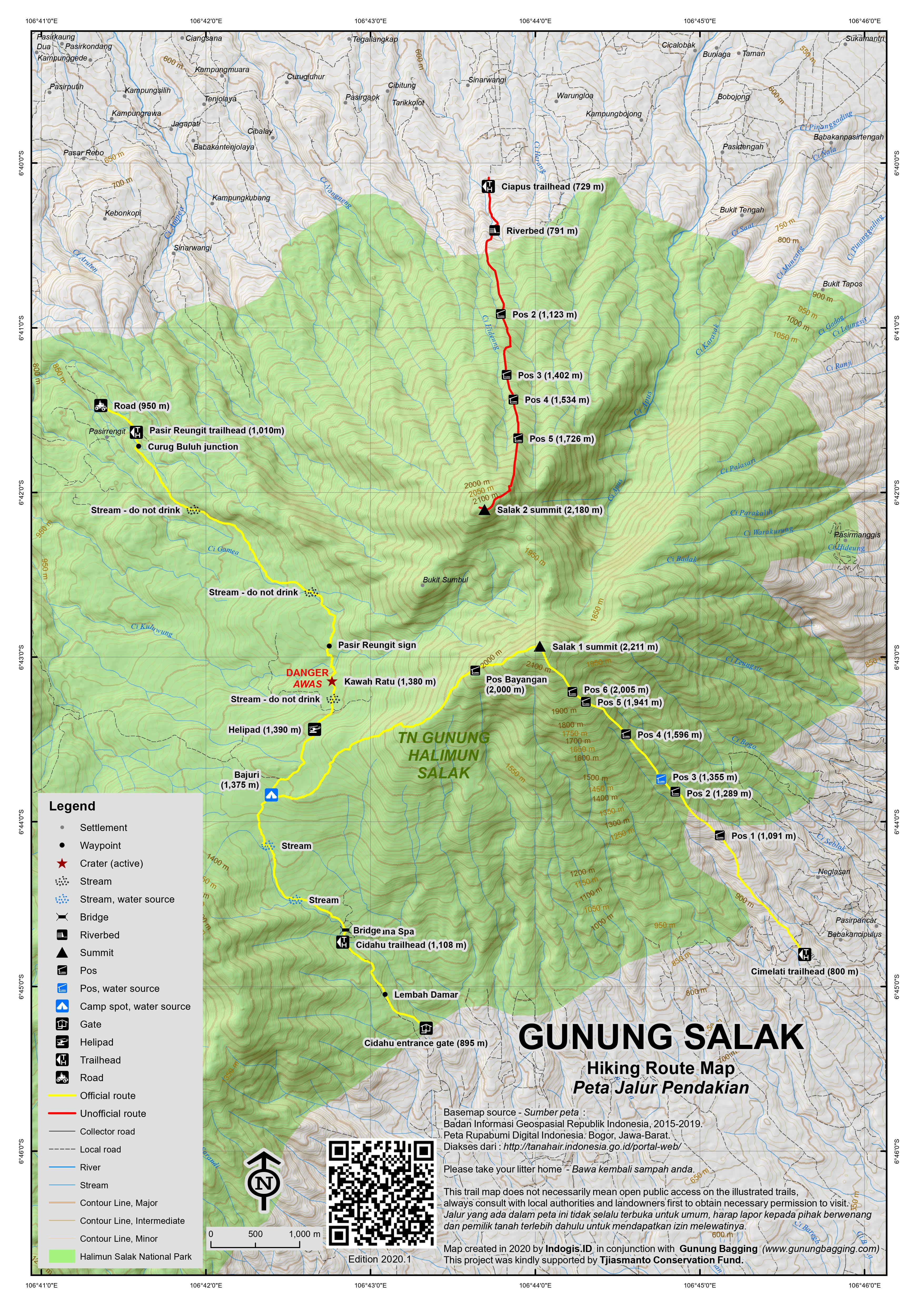
Salak is one of the most accessible volcanoes from Jakarta but has not erupted since 1938. There are various routes on the mountain range and despite being forested and generally lacking in views (except on the Cidahu route to Salak 1) there is a great deal of variety to be found on its slopes – craters, wildlife, plants and numerous mountain peaks. It is the kind of mountain that cannot be fully explored in a single hike – you need to try various routes to discover the character of the mountain as a whole. The range is well-known for being the site of many aircraft crashes, most famously the Sukhoi Superjet which tragically crashed into Gunung Salak in 2012.
Perhaps the most popular trek on Salak is from the south-southwest at Cidahu to the active crater Kawah Ratu (Queen’s crater). You can also reach Salak 1 (the highest peak) from this approach and – despite being a longer route than from Cimelati (see below) – it is increasing in popularity due to it being the official route to the summit and also due the fact there are markers on the higher parts of the trail so it is not easy to get lost. To get to Cidahu, take a well-signposted right turn for ‘Javana Spa 12km’) off the Bogor-Sukabumi road just beyond Cicurug.
All in all, the best two-day hike exploring much of what the Salak range has to offer would be to start in Cidahu, hike via Bajuri up to Salak 1 and camp on or near the top. On day 2, return to Bajuri and descend via Kawah Ratu to Pasir Reungit. Do be warned it is quite lengthy and challenging! Super-fit hikers could do it in a day, but only if they set off at 6am and barely take a rest.
NOTE: The reverse direction (Pasir Reungit – Bajuri – Salak 1 – Bajuri – Cidahu) would probably take an extra hour or two on the ascent and you would probably have wet feet within the first hour! Essentially, if you are doing a traverse then Cidahu is a better starting point. Quite a lot of hikers just head to Kawah Ratu this way and return the same way to Pasir Reungit, and it is definitely of interest if you have already hiked to Kawah Ratu from Cidahu and want to try another route.
Cidahu to Bajuri
The entrance gates and information centre (895m) are 2 kilometres before the end of the road at the Javana Spa and this is where you purchase a National Park ticket. Ask for a map/leaflet and if they have any they will give you one. It is about 30 minutes on foot up the road via Lembah Damar stalls and camping spot to the real starting point. About one kilometre before the Javana Spa the road crosses a river and there is a small but apparently now disused office building (Pos Kancil) at the start of the trail (1,108m) to Kawah Ratu and Salak 1 summit. This trail is known as the Cangkuang route. The old, now-disused path was dotted with very useful numbered wooden markers every hundred metres (HM= hectometer), as shown on the official map, but the nearby newer trail up to Bajuri does not have these (in 2018). The markers are only visible on the section between Bajuri and Salak 1 summit.
Kawah Ratu is a fairly easy 5km from Pos Kancil and because there is not much elevation gain fast hikers will be able to get there and back in 3 or 4 hours. At a reasonable pace it takes about 2 hours to reach the crater. Leisurely hikers might need half a day. The first obvious landmark after around 60-90 minutes from the road is Bajuri (1,375m, less frequently known as Cukang Batu), which consists of several grassy spots clearly used for camping on a regular basis. What you need to do here is either stay left and follow the stony track towards Kawah Ratu or, if heading to the Salak 1 summit, briefly head right, cross the little stream at Bajuri and then sharp left at an ageing metal sign with “Puncak Salak 1 – 5km” on it.
Bajuri to Salak 1 summit
National Park leaflets suggest a total trekking time of 8 hours from Cidahu to Salak 1 summit. We would say between 6 and 8 hours, depending on your speed, or between 4 and 6 from Bajuri. This section of trail is the most challenging public route on the mountain range, but also the most rewarding as there are good views of Kawah Ratu from above. You will also have fine views of the Kiaraberes-Gagak fumarole plumes in the distance to the west. The hectometer markers are mostly still intact on the higher slopes and there are accompanying metal signs on trees in some places too. The numbering starts from zero at Bajuri and the summit must be about HM50 given that the distance is 5 kilometres in total.
The first section of trail beyond Bajuri is fairly flat and boggy, with sections of deep mud to contend with. Once the trail starts leading upwards, the situation improves. From around 1,500m you should be able to hear the crater below and there are some great narrow sections of trail with views down to the left of the ridge of Kawah Ratu, especially around HM16, 27 and 31. This is probably the best section of trail on the whole of Gunung Salak.
There are countless short sections of trail where simple ropes have been tied around trees to assist with scrambling up steep, muddy or rocky sections. Most of these sections are straightforward, but less confident scramblers may have difficulty in a couple of places and may need assistance. From around 1,920m, there are pitcher plants growing on the ridge. Look out for them (Nepenthes gymnamphora, according to Alastair Robinson).
After around 3 or 4 hours from Bajuri, you should have reached Pos Bayangan (2,000m). This is the spot where many hikers end up camping if they don’t give themselves enough time to get to the summit before dark. There are enough spots for 3 or 4 tents, but somehow local hikers seem to manage to fit at least double that number!
After Pos Bayangan, the trail drops down a little before heading up the toughest, roped section of trail. Take extra care here, especially in poor weather. It takes about one hour to reach the summit from Pos Bayangan. Just before the summit is an area of beautiful old trees, some growing almost horizontally! According to National Park staff these are Vaccinium varingifolium, known locally as Cantigi Gunung. Over to the left (i.e north) is the second highest peak in the range, Salak 2. As you will see, the drop between Salak 1 and Salak 2 is considerable and that perhaps explains why the few expeditions that have hiked both peaks in the same trip required one full day to get from one to the other via this saddle.
The summit is crowned with a metal sign with the words ‘Puncak Manik’. This is a new sign (or at least a new coat of paint) since we last climbed it a few years ago. Just down to the right (east) is a metal structure and a grave. Locals often make a pilgrimage here to pray. With the increase in the number of hikers camping here regularly, and also due to the recovery expeditions after the Sukhoi crash in 2012, the vegetation is lower than it was in previous years. One of the few benefits of this is that the view of Gede-Pangrango is pretty decent first thing in the morning around sunrise. However, if hiking on a regular weekend, we recommend camping back down near the beautiful old trees so that you are not disturbed by local student hikers chatting and playing music all night.
To descend the following day back to Bajuri should take anything between 2.5 hours and 4 hours.
Bajuri to Pasir Reungit
On the trail to the crater, the next visible (in 2018) HM marker after Bajuri is is HM27. The next main landmark is Helipad (1,390m) which is a large grassy area which in 2018 had no sign on it whatsoever. From here it is a short descent to the southern edge of Kawah Ratu (1,380m) which is HM44 marker. Major eruptions occurred here in 1668-1699, 1780, 1902-1903 and February 1935. It should have taken you just under one hour to get from Bajuri to the crater.
The crater area actually consists of three craters – the Queen crater (the largest) plus the Paeh Crater (death crater) and Hurip Crater (life crater). It’s an astounding landscape: a vast hillside of white rocks, steaming sulphur gases, bubbling water and mud pools and rivers of sulphur. In terms of active craters in West Java, it is perhaps second only to Papandayan. The water here is supposed to have cleansing properties but you should not drink it due to the high sulphur content. Indeed, after heavy rainfall the water is thick with sulphur. The forested peak above the crater area is Gunung Sumbul, a subsidiary top in the Salak range.
There are poisonous gases in this area and sadly people have lost their lives, particularly when camping in the area. Therefore, although the trail to the crater makes an adventurous family day out you must be very very careful near the crater. You can either return the same way to Cidahu in 2 hours or so, or more adventurously cross the crater and head down northwest to Pasir Reungit (1,010m). From the north side of the crater (HM52 marker) to Pasir Reungit (HM89) takes about 2 hours, but much of the trail is waterlogged so expect to get your feet wet. For those descending from the summit, official Park leaflets suggest it takes 11 hours from Pasir Reungit to the summit (likely a slight exaggeration), but in our experience you can descend in between 5.5 and 7.
Pasir Reungit means ‘mosquito sand’ in Sundanese and although it thankfully does not live up to its name it is a rather troublesome place to find transport back to Bogor from. Ojeks or a pre-arranged pick-up are the best ideas here. Otherwise, walk for 5km down the road (950m) to Gunung Bunder and get onto the first of about 3 different public angkots needed to get back to Bogor. The 4G signal near Pasir Reungit is poor so searching for a Grab driver or similar may not be possible.
One-day hike to the summit of Salak 1 from Cimelati (supposedly this trail is being made official in 2020!)
The best starting point for those wanting to reach the highest of Salak’s seven summits in just one day is from the agriculture station near Cimelati (800m) just beyond Portibi Farms (c700m) – there is a signpost where you take the right turn near Cicurug. Cimelati is southeast of the summit. It takes between 4 and 6 hours to reach the summit which, as mentioned above, features a prominent sign, a gravestone and a shelter. It is a steep but straightforward hike through forest to Salak 1, and the forest does thin out a little as you get close to the summit. The trail leads via Pos 1 (1,091m), Pos 2 (1,289m), Pos 3, Pos 4 (1,596m), Pos 5 (1,941m) and Pos 6 (2,005m). The last spot for water is Pos 3 at around 1,300m. You may be lucky to spot the elusive Javan Ferret Badger on the upper slopes. Despite being forested on top, you are rewarded with views to Salak’s other lesser summits, the Gede-Pangrango massif, and outlying suburbs of the city of Bogor below.
Note : The Cimelati route is likely to become an official National Park route in late 2020, as so many hikers use it despite it being unofficial. At the time of writing, however, official access is still a grey area.
Salak 2 (access remains a grey area)
The second highest, and more northerly peak, Salak II (2,180m), is best approached from Curug Nangka or the Highland Park resort, Ciapus, to the north of the mountain (at approx. 729m and just 40 minutes from the centre of Bogor). This is slightly more challenging than Salak 1 and access is, once again, a grey area. The trail leads via Pos 2 (1,123m), Pos 3 (1,402m), Pos 4 (1,534m) and Pos 5 (1,726m) before reaching the summit.
It may or may not be open to hikers. It would appear it can be done if you pay for a senior member of park staff to accompany you on the trek but they are difficult people to get in touch with. Officially, since 1999, this route was closed to all hikers except if you were conducting scientific research. It was basically because the National Park did not have sufficient resources to enable that the trail was well-maintained and they were worried about people having accidents because they would be responsible. In September 2011 it was discovered that hiking to Salak 2 from Curug Nangka was possible, but only if you requested permission a minimum of one week in advance from the resort at the base of the mountain near Curug Nangka. Impractical, to say the least, but, if true, it’s a step back in the right direction finally, especially considering that’s it’s the closest significant mountain hike to Jakarta.
Please note: Gunung Salak is part of Mount Halimun Salak National Park which is closed entirely from December to March and August. Oh, and Idul Fitri. Hikers are supposed to register before their hike. Check the National Park website for more information.
Bagging information by Daniel Quinn and Andy Dean (updated April 2020)
Trail Map
For a high quality PDF version of this and other trail maps, please download from our Trail Maps page.
Practicalities
- Getting there: For domestic flights we recommend Baolau. Take a train or bus from Jakarta to Bogor. For the Cidahu route to Salak 1 or Kawah Ratu, take the Pangrango train from Bogor Paledang station to Cicurug and then charter an angkot to Cidahu. For Pasir Reungit, it is complicated with numerous angkots required so best use private transport. For Salak 2 from Bogor, take an ojek or angkot (number 03) to Ciapus near Curug Nangka.
- Guides and GPS Tracks: Want a PDF version for your phone? Looking for a guide? Need GPS tracks and waypoints? Gunung Salak information pack can be downloaded here.
- Trip planning assistance: Would you like Gunung Bagging to personally help you in arranging your whole trip? Please contact us here.
- Permits: Available at Cidahu and Pasir Reungit. Cimelati is an unofficial trailhead. At the information centres at Cidahu and Pasir Reungit, tickets costs Rp5,000 per person per day for Indonesians and KITAS holders plus Rp5,000 camping fee and Rp2,000 insurance (all this is overly-complicated with lots of different bits of paper so just assume no more than about Rp25,000 per person for a two day hike), but if you’re a foreigner who doesn’t have a KITAS they will charge you the Rp150,000 per day ‘tourist price’ for those who committed the sin of being born elsewhere. Serious access issues remain for Salak 2 despite it having been a common hiking route for decades before the trail was closed in 1999. A minimum of 3 people in a group is stated on the pamphlets but in 2018 there seemed no problems going as a group of just 2 from Cidahu. The Cidahu office is open from 8am until 4pm. The Pasir Reungit office is open from 7am and they don’t like hikers setting out after 11am, though this may only apply to those going on a one-day trip to Kawah Ratu.
- Water sources: The last place for water on the Salak 1 Cidahu route is Bajuri (1,375m) so fill up your bottles here. Lots of streams are crossed on the main trail between Cidahu and Bajuri and then Bajuri and Pasir Reungit, but avoid water from too near the crater (Pasir Reungit side of Bajuri). On the Cimelati route, Pos 3 (1,300m ish) is the last spot for water.
- Accommodation: Try the Booking.com map above or use this link to search for suitable hotels, homestays, resorts and apartments for your trip.
- We recommend Safety Wing as travel insurance for overseas travellers and tourists hiking up to elevations not exceeding 4500 metres.
Local Average Monthly Rainfall (mm):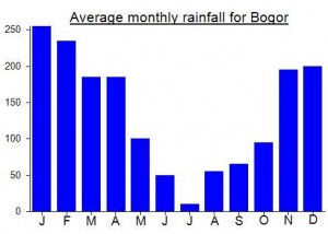
Location
Click on the blue arrow ![]() (top right) to see your current location on the map
(top right) to see your current location on the map
Origins and Meaning
Supposedly named after the Sanskrit word ‘salaka’ meaning ‘silver’. Therefore Gunung Salak means ‘Silver Mountain’.
Previous suggestions: Apparently named after ‘Salaka Domas’, the ancient megalithic monuments which scatter the land surrounding the mountain. (According to Pepep of Bandung, 2012).
Another previous suggestion was: Snakefruit Mountain. Possibly so named because from a distance the mountain has a rough, brown appearance like that of the “scaly-skinned” salak or snakefruit. (George Quinn, 2011)
I hiked Salak from Cimelati today. All the information and comments here were really helpful. I went alone and there was no objection from the trailhead staff about that.
I got started around 8:45am. I got to the summit at 11:20 (under 3 hours), and coming down took roughly the same, for 5.5 hours total.
I only encountered about five small groups on my way (it’s a Monday), and all were coming down from the summit and were above Pos 4 when we passed. At the summit, there was only one group. Weather was not ideal and there was no visibility, so I didn’t stay too long up there.
If there’s anything I’d warn others of, it is perception of distance on the way up. I felt like I got to Pos 3 pretty quickly, but then it was unexpectedly far to Pos 4, which was demoralising. I thought I had missed the Pos 4 sign and that I was coming to Pos 5, so when I saw it was 4 I had to pump myself up a bit. I thought it was just in my head, but coming back down I was paying close attention and it was the same experience. So just keep that in mind, that 3-4 is/looks further than on the map, so don’t get discouraged (or drink all your water too early or something – also I didn’t see the water source at Pos 3).
I hope to try the route from Cidahu next time. Thanks for all the advice here.
Myself and 8 others did a lovely day hike yesterday to Salak 1 from Cimelati. That route is now 100% official, and the ticket post is very well-equipped with toilets, a warung, etc, and in the lower stretches there are even national park signs explaining local wildlife etc. We saw probably 50 other hikers somewhere along the hike, so it’s neither packed like Gede nor completely empty. If you register online, it seems impossible to either only register for a single day permit, or to register for the local price without a KTP (the website wanted 2 x 150rb for myself alone). But at the ticket booth, showing them the KITAS of the foreigners in the group and explaining that we were just going up and back same day worked to get the price of 30rb/person.
The hike itself goes through really beautiful thick forest and involves lots of climbing over roots and mud. Steep and steady – especially between pos 3 and pos 6 – but ultimately not as challenging/terrifying as some reports I’d heard. We left the ticket booth at 6am and the people in the group reached the top between 9:45am and 10:30am. Stuck around for about an hour up there and then we were all back down before 3pm. There were no water sources available along the trail – the guides said there was often one at pos 3 but it was dry now. From the peak, we could mostly just see clouds, so next time I might try going overnight to reach the peak for sunrise. But overall still a very enjoyable and worthwhile way to get out of Jakarta and spend some time in nature for a day.
Anyone interested in megalithic sites like the much more famous Gunung Padang near Sukabumi might be interested in visiting Arca Domas Cibalay just under one hour from Bogor station by car and on the slopes of Gn Salak. The photos on Google Maps look pretty interesting.
The mysterious lesser peaks to the west of Gunung Salak – Gunung Perbakti (1,699m) and Gunung Kiaberes-Gagak (1,511m) are starting to become a little better-known, perhaps inevitably due to being so close to densely-populated areas of Java and due to Google Maps.
The latter in particular appears accessible from Karang Endah (roughly 800m elevation) to the north. But rather than the summit it is Curug Cikawah (a waterfall with hot water and fumaroles, roughly 1,100m elevation on the NE slopes of Kiaberes-Gagak) that is the usual destination, taking about 2 hours each way from Karang Endah on a rough, tough, overgrown trail that a local guide from the village is required for.
But, as is the important question to ask in Java these days, how official is it? It’s in the National Park, so technically it means you need a permit. Will the authorities decide to make this trek official, or will they do the opposite as is equally likely and start blacklisting people for using it? Time will tell…
I have noticed a few references when reading the local news recently to ISIS inspired militants conducting training by going hiking in the mountains of Indonesia. Quite worrying. I did a quick google search and found this…
https://fajar.co.id/2017/09/09/12-santri-bogor-jadi-militan-isis-satu-tewas/
This is very close to the unofficial start point for Salak 2, and only a few kilometres from the northern entry point for Salak 1 and Kawah Ratu from Pasir Reungit. Highly unlikely that training terrorists would use an official entry point to a national park hiking route… but you never know.
This kind of thing is perhaps to be expected in known trouble spots in certain specific areas of Central Sulawesi, for example. Sad to see the closest significant mountain to Indonesia’s capital also play host to such horrific antics. Will be interesting to see if this trend grows. One of the few benefits of Java’s mountains being so popular these days is that you are unlikely to come face to face with such militants except in the company of many others.
Just did a great hike out to the Queen Crater along the Pasir Rengit route! Hiking during Ramadan is fantastic, we practically had the mountain to ourselves! It was a great refreshing day in nature and although the route was quite wet we found it quite easy to follow. It’s well market with signs for the crater and return route. Saw some monkeys, lots of dragonflies, and of course the spectacular crater. 3 hours up and 3 hours down at an easy pace with my pregnant wife including a short lunch stop and some time to explore and admire the crater.
We stayed with the friendly Pak Rachman (+6285691492552) at the De Salak Guesthouse and arranged all of our transport though him which helped us avoid the chaos of trying to find transport around Pasir Rengit. The guesthouse was simple and comfortable and just a few minutes drive away from the Pasir Rengit trailhead making it a great place to relax before or after your day hike if you choose that route. Pak Rachman speaks good english and can help arrange anything you need in that part of the mountain or if you want to traverse from Cidahu and need transport or a place to stay in Pasir Rengit when you finish.
Just back from another Salak mission. We did the Cidahu to Cimelati traverse (GPS track posted). Started at Javana Spa (Cidahu), up to the summit of Salak-1, then down to a finish (and cold beer) at Portibi Farm (Cimelati). After having done a few routes on Salak, I think this is my favourite Salak mission. The obvious nice thing about it is, you go up one route, then down another. We did it as a day trip, which is doable, if you get an early start, have a light pack, and just “give ‘er”. Start to finish took us just under 8 hours, but not a lot of down time – you want to keep moving (4ish hrs up, 3ish hrs down, + lunch).
We started right at Javana Spa, which is a nice place to start since it is at about 1200 m. Thus the climb to the summit (2211 m) is +/- 1000 m of vertical. The security people there seem very open to letting people in and pointing them in the right direction. The trail from Javana Spa meets the main park trail at the junction where: right = the summit, straight = the crater (Kawah Ratu). The summit trail is a bit sporty in spots, requiring near-vertical scrambling with the aid of in-place ropes, but nothing too death-defying (but might be a bit scary to the unaccustomed). The trail tends to follow the high ridgeline, which is nice. All in all, a nice route to the summit – and obvious, i.e., you can’t get too lost.
The summit itself is unfortunately not that impressive. It is forested and does not offer much of a view, especially since in the middle of the day it is almost always in cloud cover – but does make for a good lunch-break spot.
The descent to Cimelati starts right at the summit (the obvious trail going down beside the marked grave). It is a bit of a grunt, and more of a waterfall than a trail. From here to Portibi Farm/Cimelati at 700 m, it’s a 1500 m descent. It is quite steep, laden with roots, drop-offs, rocks, mud, muck, and things of that nature. It is hard on the knees, and if wet, can be very trying to point of being dangerous. However, it is very direct, if you like that sort of thing.
Summary: nice way to do Salak, but requires a drop-off in Cidahu/Javana Spa and a pick-up in Cimelati. Not for the uninitiated, this is a big hike, and requires good fitness, proper gear/footwear, and decent route-finding skills. Bring lots of water, although drinking water is available at Pos 3 on the descent (see GPS track). If you are unsure of routes and logistics, contact Portibi Farm (google it), they’ll set you up (advance notice required).
Update on Cimelati access: When we came down, at the end of the trail, where it meets the paved road, the exit/entrance is now blocked (as of 27 May, 2018). The land owner, who owns the land around the access, is discouraging use of this access point, meaning he has made it difficult to get through the 25 m or so, between the end of the road, and the beginning of the trail. There now is a lot of vegetation, fences, barbed wire, and a water tank between the end of the road and the trail. We squeezed through, but it is not obvious where to go. However, because it is only a gap of 25 m or so, you can simply bash your way through, and/or find a walk-around somewhere. Doable, yes. Legal? Not sure.
Park fees? It was Ramadan (which is the perfect time to hike in Indo; no people), so we literally didn’t see anyone, much less a person collecting fees. There is a gate/office on the road up to the Cimelati access (past Portibi). Latest info though, is that this is not a park office. It is something the landowner put up. They may stop you, and may ask for money, but just keep in mind this is not an official park office. However, they are friendly, and it is a good place to park and start/end your hike.
Hadn’t been up to the top of Salak 1 since 2009 so I thought it was time to make a repeat visit, but by a different route. The traverse from Cidahu to Pasir Reungit via the summit must be the toughest regular trek on the range, requiring two full days.
As usual, I stayed in Bogor on the Friday night for an early start on Saturday. Caught the Pangrango train at 0750 from Bogor Paledang (small station hidden near Jalan Paledang for services to Sukabumi) to Cicurug (arriving 0848). There is one executive coach (Rp50,000) but it sells out very quickly, especially for weekend services. Unlike other executive train tickets which can be bought 90 days in advance, this one for some reason can only be booked 30 days before, so if planning on using it I would book as soon as you can once they come on sale. It certainly saves a horrible congested car journey from Bogor to Cicurug and in clear weather is very nice indeed. It’s also the latest I would recommend getting to Ciciurug for. After 9am means a hotter hike and less chance of getting to the summit before dark.
From Cicurug, there were one or two grab cars available, but by the time my co-hiker had arrived by road they had all been taken so we had to charter an angkot. There are plenty just on the main road near the station. We got it for Rp80,000 up to Cidahu entrance gate. This is only about 10km but it took well over half an hour due to the usual pot-holed, speed-bump ridden, congested mess which is the norm in West Java now.
If I’m making this sound like an unpleasant ordeal…. Well, yes, the getting there and getting back can be, but the hike itself was wonderful, a much needed return to sanity and space and quiet. Having a KITAS, I got the local rate for entry which is fair enough given the tax we pay every month. Rp150,000 a day for tourists is a bit much in my opinion, especially given that the trail to the peak has numerous tree trunks that need clearing away and that many of the wooden hectometer (every 100m) markers that once made navigation easy if you had the national park leaflet have now either become rotten or been stolen and used for firewood. The same applies at Bajuri and Helipad. Where are the discreet signs telling you where you are? If you are going to charge foreign tourists Rp150,000 a day just for being there, you really ought to maintain the trail properly.
The area around the entrance was busy with local tourists. At least half of them were just doing family camping trips in the woodland just beyond the entrance gate. The supposed need for minimum 3 people in a hiking team seemed to be ignored or forgotten as there were just two of us.
From the entrance, it is a good kilometre or so (i.e 30min or more on foot) to the proper trailhead. You can probably get an ojek up there if you need to save time. We walked up and got started at the proper trailhead at 11am. We were up at Bajuri by 1215pm. There were lots of student hikers as usual, but many of them did not make it to the summit the same day, either due to lack of fitness or too many noodle breaks!
The first section of trail after Bajuri is not very appealing as it is thick mud in places. Afterwards things really improve. It’s a great view of Kawah Ratu from above. There are pitcher plants on this ridge and some very interesting fungi. We were ok with the roped bits, but one spot especially after Pos Bayangan could be trouble for those lacking confidence in the ropes.
We were at the summit in 4 hours from Bajuri, but given it was a weekend we wisely camped a couple of minutes before the summit sign, next to a near horizontal tree. It was quite magical at dusk, with lots of fireflies and starry, starry skies. Very peaceful. Had we camped next to the absolute summit, we would have had very few hours of sleep, as the usually quiet Indonesians seem to more than make up for things when outdoors by shouting unnecessarily loudly and singing and playing music. At least there were no guitars this time! Too difficult to take one up the roped sections!
I would estimate that about 50% of the campers at the top had come up from Cimelati and 50% from CIdahu.
We set off back down to Bajuri before 7am, in order to get some good views of Kawah Ratu before the late morning haze set in. Took us 2hr 45min in total and a further 35 minutes to Kawah Ratu. From there it was about 90 minutes going at a reasonable pace down to Pasir Reungit.
It was a mess getting back down to the main road into Bogor. We walked down to Curug Cihurang, then ojeks down to Gunung Bunder, then an angkot to Cibatok (Ciampea would have been better). Traffic was solid, and the roads just too narrow for two-way traffic, especially with bikes and angkots left casually at the side of the road. A bit of a shambles. No Grabcar wanted to drive us back to Bogor due to the hideous traffic jams, but we fortunately got Grab bikes for about Rp50,000 each and overtook much of the jam. Then a train back to Jakarta.
Just back from another gunung bagging up Gunung Salak. In a word, this hike is a grunt. But alas, aren’t they all? We did the route up from “Cimelati” (as in the overall description above). From all accounts, it is the most direct route to the top, and, has the added bonus of being closer to Bogor/Jakarta than the Javana Spa route (Cimelati trailhead = 1 – 1.5 hrs drive from Bogor). If you are unsure where this is, google “Lodges Ecologika on Portibi Farms”. The trailhead is just up the road (i.e., the end of the road) from Portibi Farm, an eco-resort in the foothills of Gunung Salak. In fact, we started and finished at Portibi Farms, which is highly recommended if you are looking for good food and fun accommodation mixed with hiking on volcanoes. Makes for a fantastic weekend!
Ok, the climb: not for the faint of heart, this is a vertical trail that goes straight up the hill to the top, no slack. The trailhead/Portibi farm is at about 700 m. The summit (Salak 1) is 2200 m. Do the math. Lots of vertical, and the “trail” really isn’t a trail, but more of a root-infested drainage ditch which turns into a waterfall if it rains. Do not even think about doing this in wet season. It’s a waterfall.
Once on the trail, it is straightforward, and easy to follow. No need for a guide, despite what anyone might tell you. If you are unsure, organize a trip through Portibi Farms, and they will set you up with whatever you need. At the end of the road, past Portibi, you will hit a park office, with park staff. They will likely require some kind of payment. I gave them 50K Rp, and they seemed happy with that.
In dry season, under reasonable conditions, the up is about 4 to 6 hours, with the down, well, not that much faster. It’s a big hike. Do not take it lightly. It’s that kind of trail where the down is just as hard as the up. We have done it in a day, which is doable if you are reasonably fit and used to hiking this kind of stuff (plan on a long day). The other option, which is also tough, is camping up at the top, which means you are carrying a big pack. After doing both, I think I would just go with the up-and-back in a day. The camping at the top is less than stunning, because there really aren’t any views. The top is forested, and really doesn’t offer much reward in terms of views, unfortunately. And, you will be sharing the summit with the usual hoards of chain-smoking teenagers who frequent gunungs these days.
Summary: on a nice day, with light packs, and an early start, this is a fun climb, provided you have the fitness and experience to enjoy it. The forest all along the way is spectacular, and you will likely see monkeys and other wonderful things. This should not be your first hiking experience though.
HOT TIP: there is a new water spring pipe/spigot (i.e., DRINKABLE SPRING WATER) at Pos (camp) 3, at about 1300 m. It’s pretty much half way, so it is a great spot to stop and drink a lot of water, fill up water bottles, and then head for the summit!
Harap dicatat: Gunung Salak merupakan bagian dari Taman Nasional Gunung Halimun Salak yang ditutup seluruhnya dari Desember
Today I climbed Gunung Salak again using the Cimelati trail. We were not asked to pay anything. (Nevertheless we gave the security guy 20000 IDR.)
The water supply at pos 3 is now very good. A real water tap was installed. Still the Cimelati trail offers a very nice hike.
Tips Ascent Salak Cidahu lines:
– Fill keril wrap with trash
bag / large garbage bag
(By entering the mat to
in trashbag form
circle) keep clothes
food night tents were not
getting wet because of the rain.
– Bring clothing replacement
warm in the form of shirts, pants, T-shirts
legs, gloves and skullcaps
backup plus a sleeping bag.
– Use flysheet to hold
rain water into the tent.
– Use dried leaves
as the base tent in order, the tent is not
directly touch the ground.
– Create the waterway around the tent, so that
water flow is not menujju parts of footwear
tent.
– Water should be taken after
basecamp there are streams,
and refill again before
Bajuri T-junction on the flow of water
small ditch. because after
Bajuri-junction is no longer
water sources.
– Lighters order in packs do
wet / wet to be tetep
used.
– Bring plenty of water in order to
share if the excess.
syukur.suhardi89@gmail.com
–Update for Salak I via Cimelati–
If you need to target a google-maps location for the entrance, type :
Masjid Al Huda JL Kutajaya
There is an entrance just before it where you can park your vehicule. A security team now works at this entrance. They charge 5.000rp for a day and 25.000 for the w-end.
Since recently, they (not always as we saw people without ticket later) charge you to get in.
5.000rp for locals and an scurrilous 150.000rp for foreigners !!
(After 25min explaining that I have a KITAS, they let me pay 30.000rp)
The trail is progressively steeply along POS 1 to 6.
POS 1 : possible camp area
POS 2 : good camp area
POS 3 : Water
POS 4 : possible camp area
POS 5 & 6 : only resting area
POS 7 : Summit ! good camp area
It Takes between 3 and 5 hours according to your capacity.
+ If you come from Bandung, I would advice you to take the high-way all around via Jakarta. We enjoyed our time via the city of Sukabumi but the National Road 3 was a nightmare in term of traffic 🙁
I climed Gn. Salak last Sunday from Cimelati. Compared to the climb from Javana Spa, which I did last August, it is much easier and faster. I needed three hours with heavy rain in the upper part and a couple of breaks. Under good conditions you can climb it in two hours and a half from the farmland above Cimelati until where you get by car. A big advantage of the Cimelati trail is that there are no swamps, which is quite ugly in the Javana Spa trail. And it is less steep. On the other hand you do not have the views to the Kawah Ratu and you cannot combine the climb with the visit of the crater. Gn. Salak through the Cimelati trail is a perfect hike for people who are not used to do long hikes but want to try a semi-serious mountain.
Salak remains out-of-bounds since the Sukhoi Superjet crash. Apparently the mountainside is still littered with wreckage. It could well remain closed for several more months. Contact Taman Nasional Halimun-Salak to check before going.
I lived in Djakarta, working at the British Embassy between 1968 and 1971. The embassy, at the time, had two bungalows below the volcano and we often walked to the cratewr rim, sometimes staying overnight at a hut in the forest. It was a slippery but worthwhile climb. There were not too many visitors in those days, but I do recall one Indonesian who carried his bicycle from the base to the rim, and back. This all before the days of national parks and permits
Anyone know the best and least crowded spot to pitch a tent and camp with little kids somewhere in TN Halimun… so somewhere you can drive to?
Thanks
James
Bogor
Myself and a couple of other hikers were supposed to be climbing Salak 2 from Curug Nangka today. It appears that after several years it is now permissable for hikers to climb on this route (a route which really never should have been ‘closed’ in the first place, given that it’s the closest mountain to Jakarta and Bogor).
Anyway, our guide contacted us late last night to let us know that you have to ask for permission to climb Salak 2 a minimum of ONE WEEK BEFORE you wish to hike. So we had to cancel.
The mind really does boggle! How can this possibly be a good policy? First of all, it is questionable whether or not a mountain ought to be ‘closed’ at all unless as a result of volcanic activity (which is not the case here). Gede-Pangrango is overcrowded these days and hikers dearly need other options near Jakarta to spread the load a bit.
The process of getting ‘permission’ to climb is something of a grey area to me but from what I can gather you need to ask at the resort (!) at the base of the mountain near the Curug Nangka waterfall (possibly ‘Highland Park’ resort???). This presumably means two trips there – one to request permission a minimum of a week in advance and then a second trip to climb the bloody thing!
Nice to see that rational thought is alive and well in West Java!
I’ll probably give this one a try in October if the ‘paperwork’ can be arranged.
For Salak 2: 4 hours up, 3 hours down.
Start 675mdpl near Highland Park.
Houses – 750mdpl
Pine woodland & sign – 750mdpl
Pos2 – 1122mdpl (last water)
Pos3 – 1400mdpl
Pos4 – 1535mdpl
Pos5 – 1726mdpl (best Pos for camping)
Monument – 2160mdpl
Salak2 Summit 2180mdpl (good views of Salak 1 between monument and summit)
Notes: lots of monkeys between 1000-1500mdpl. nettles on first section. a bit steep and slippery from pos5 to summit. excellent views on summit ridge. nice hike.
So ‘Anon’, no comment about Bureaucracy or permissions.Be useful if you can clarify.Did you go up there by yourselves?with nat park guide..if so pay how much
Is there any sensible path from salak 1 to salak 2 making a traverse possible?
We went with a guide, who shall remain nameless, not from the National Park as it seems they will still only take you if you are conducting research and fill in tons of forms (even more if you are non-Indonesian) – or presumably if you hand them a fat brown envelope. The trail is pretty straightforward though. I think Highcamp made a trail across the saddle between 1 and 2 so a traverse can be done but I think it takes a full day.
Just had a great hike up this weekend with a group starting at around 10pm and arriving on the top around 3.30. We realized that we had started a bit early so we took our time on the way up, with plenty of nice breaks. Conditions quite wet with light drizzle so we were freezing when we got up there with damp clothes! Nice sunrise around 6am and laying around in the sun for a few hours helped to warm us up. Then a 3 hour hike down with plenty of time for photos.
Guests to Gunung Salak should look into the PORTIBI farms and Ekologika lodge, a cool eco-lodge and organic farm set up by a long-time Jakarta expat. They can provide guides for the mountain and also comfortable lodging for when you get down! Close to Cicurug village. Complete info available on Facebook.
4 of us ‘bagged’ Salak 1 on Sept 5th 2011, up from Cimelati.
Just want to confirm times, 4-4.5hrs up, 3-3.5hrs down for a fairly strong group.
Nice forest, relatively unspoiled.Quite a bit of bird and primate life.
We were a bit concerned about not being able to find the right turn, but the turn to Cimelati is well signposted, as you enter cicurug..then head staight up to Petanian Cimelati
I used your contact information via Latif and he refered me to a nice young man named ‘Aldi’ who took me to the top of Salak Satu. We stayed a night on the mountain which was really cool considering how so many Indonesians consider Salk to be laden with spirits and otherworldy creatures. I must admit that all the folklore stories added to the ambience of the whole mountain. I’ve passedby this mountain a couple of dozen times since moving here five years ago and it was a real accomplishment to finally bag it. A lot of hard work after all the hard rain. I am not sure if it’s because there is a substantial gain in altitude but coming back down the slippery trail was a real challenge to put it mildy. we took the route via Cimelati and it was a nice climb and we were back in Jakarta by the next evening. Thanks for the contact info, it helped out a lot as a volcano that’s been pointing it’s finger at me for years was finally bagged. thanks.
You’re welcome, see you Mr. Zac 🙂
Yesterday, 13 of us went up to the Javana Spa, for the hike to Kawah Ratu. This was the David Jardine Memorial Walk. Dave was a great journalist (formerly teacher) who passed away in April. He had always had a fascination for Gunung Salak and spent many happy hours watching the sun set over its slopes from the Salak Sunset Cafe in Bogor. It was his wish that some of his ashes would be scattered on its slopes. A new website has just been set up to publish his writings….. http://davidjardine.net/
Not everybody made it to the crater, but the weather stayed reasonably fine and it was for the most part an enjoyable day trip out from the urban chaos of Jakarta.
Unfortunately, there are a few negative things that must be said about what should be quite a simple trip from Jakarta and back!!! Firstly, a new barrier has been erected further down to Javana Spa road, so everyone who wants to use the road up to the Javana Spa must pay an additional Rp2,000. It’s a very small amount of money, granted, but the road is a public road and this sort of highwayman behaviour seems to be becoming quite widespread in West Java, whereby road users are expected to fill the pockets of some local chancers just for using the road through the village! I’ve experienced it in the hill roads north of Bandung and also near Pelabuhan Ratu. Very odd, quasi-official ticketing. Whether the money is spent on improving the road or area is, I think, fairly obvious to anyone with even a basic knowledge of Indonesian society!
The other issue is at the information centre further up the road where they, quite officially, always try to charge anyone non-Indonesian almost ten times the price for entry. Again, it’s not the actual cost that is the issue here, but the ‘us and ‘them’ racist mentality. There is also another sneaky trick whereby if, for example, you pay for 12 tickets, they try to give you just 8 or 9 so they can personally pocket the difference in ticket price. Pathetic, sad behaviour.
On the positive side, the security chaps up at the (seemingly always empty) Javana Spa were very friendly and helpful and let us park the minibus next to the security post for a small payment.
Getting back to Jakarta afterwards could only be described as a nightmarish ordeal!! We used the Jalan Alternatifs to try to avoid the worst of Cicurug and Bogor but even so it was painfully slow going. Then we finally limped onto the toll road to find that it was at best 10km per hour the entire way to Jakarta. It took us about 6 hours to get from the Javana Spa to the outskirts of Jakarta (which seemed deserted by comparison). It was so horrendous that instead of adjourning to Jalan Jaksa for a few drinks in memory of Mr Jardine, some people drifted home to forget the nausea of the journey. Some of us managed to retain enough energy for a quick bite to eat and beer at the excellent Ya Udah Bistro near Jl Wayhid Hasyim (Menteng).
The Bogor – Sukabumi road must rank among the worst in Indonesia, so be warned! You might be better just flying off somewhere instead of try to do something local!
Thankz Mr.Daniel and Mr.Heinz 🙂
(latif)
High Dan,
Good morning from Bali I hope this note finds you well.
Dan I am invited on the 19th to visit the Equil factory in Cimelati and will spend two nights somewhere in this village.
Obviously going there and running up Gunung Salak would be a waist of time. Would you have a contact for a guide which could meet me 2 am in the morning and lead me up the mountain.
We did Tambora two weeks ago and when we reached the top we saw about three meters. Definitely have to go back. I have now a book project in Flores and propably will climb most of the mountains there this year.
Would be great if you can send me a number and contact for Salak.
Wishing you a great weekend, thank you for your help and best regards
Heinz
Hello Heinz! We climbed Salak without a guide so I don’t know anyone that I have actually met. But you could try the following person who may be helping me with a hike on Salak later in the year….
Latif 085695759365
thanks Dan,
I tried to make it to Salak via the same road you suggest back in 07′ and a torrential downpour thwarted my endeavors. If you have a chance to share the GPS tracks,please feel free to send them to my email rinjani72@gmail.com. I’ve got an itchin’ to bag one more mountain before December hits.
If anyone has any recommendations as to how to find a reliable guide up this peak. I am all ears. It is so darn close to Jakarta and it is a shame that it is so difficult to find a guide. If the local authorites only new how many willing ex pats would make the jaunt over there to grab a quick summit and return. They could turn useless administartive barking into commerce for the locals.
If you go to Javana Spa on the Sukabumi road you can hike either to the crater or to the summit of Salak 1. You have to buy a ticket at the national park office and they insist that you take a guide. Alternatively, we list a route up Salak 1 from near Cicurug off the same road – the trail is clear and I can share the GPS tracks. The main problem is the traffic, which is mindboggling along the Sukabumi road because of the trucks, bemos and markets. Leave Jakarta very early.
For several weeks, I have been trying to arrange a hike to both Salak2 and Halimun Utara (North) which is the highest Halimun peak. Sadly, I have gotten nowhere. After finally managing to get in touch with a member of National Park staff, I explained that I wanted to climb to these peaks and that I would be willing to pay for a guide to help me do so. I was informed, politely, that because neither route is considered by Park authorities to be an official hiking route that it is actually ILLEGAL (!) to climb them. Very strange considering that Salak2 was commonly climbed in the past and should be considered a traditional hiking route (and therefore remain open). Salak2 is actually closed because the National Park does not have enough resources to keep it open – perhaps the Park should think about reducing the size of the Park boundaries then? Instead of embracing the opportunities of employing more people to take local and foreign tourists on a wider range of routes they decide to simply deny anyone the legal right to visit these areas.
The only way that you can officially explore these important places is if you are conducting official scientific research.
This is a real shame for all hikers in Indonesia, especially as Halimun and Salak are two of the nearest peaks to Jakarta.
I hope that some Indonesians will help to campaign for a change in the law which recognizes that hikers can be responsible for themselves and that National Parks are not supposed to prevent people from entering them. It is the same in East Java at Ijen-Merapi where climbing Merapi is technically illegal. This problem is likely to grow in size unless something is done to change the law and allow hikers greater access to these places which they deserve to have. Otherwise, bribery or paying a fine is the only way to enjoy visiting these mountain peaks. A ridiculous situation!
First of all, it’s Cimelati, not Cimolati. From Cimelati we can reach the peak of Salak 1. Another route to reach Salak 1 is from Cidahu.
Trip to Salak 2 from Curug Nangka is for experienced hikers only as this route is quite dangerous (steep trail, ravines etc).
Always register your hike to national park staff.