
Facts
- Elevation: 3,145 m (10,318 ft)
- Prominence: 2,432 m
- Ribu category:
 Sangat Tinggi
 - Province:
 Jawa Tengah (Central Java)
 - Coordinates: -7.4542, 110.4397
- Rating:

 (45 votes) Add your rating
 Loading...
 - Other names: ꦒꦸꦤꦸꦁꦩꦼꦂꦧꦧꦸ Highest peak is called Triangulasi.
- World Ribus ID: 69022
Photos


Bagging It!
This Ribu is one of the most popular hikes in Central Java, and has spectacular views to other volcanoes in all directions from the summit area. It has five calderas, Condrodimuko, Kombang, Kendang, Rebab and Sambernyowo but no serious volcanic activity has been reported here for many decades. Merbabu can be climbed from several trails near Kopeng in the north (less than two hours by car from Semarang) with starting points at Thekelan, Cunthel and Wekas, or from the south at Selo (between Merbabu and Merapi and closer to Solo).
There are also newer trails from the west at Suwanting and Grenden which are getting popular with hikers from Yogyakarta. As is often the case in Central Java, the basecamps at the trailheads (especially Wekas and Cunthel) are great places to get some rest, cheap coffee and noodles, and chat to other hikers.
The best hike is probably a traverse from north to south, because the climb from the north is a gentler slope and there are great views to Merapi when descending on the southern route. However, for those travelling from Jakarta for the weekend, it probably makes sense to use two of the northern trails as buses and trains to/from Semarang take at least two hours less than to Yogya and Solo. Do note however that there is a tricky section of trail just below the summit when approaching on one of the northern routes and not all hikers may be keen to attempt this.
This hike could be completed in a day by very fit people, but an overnight stay on one of the summits is recommended. From the north, the hike is called the “seven summits” based on the fact that are indeed seven summits, although a few of them are more of a small bump on the ascent.
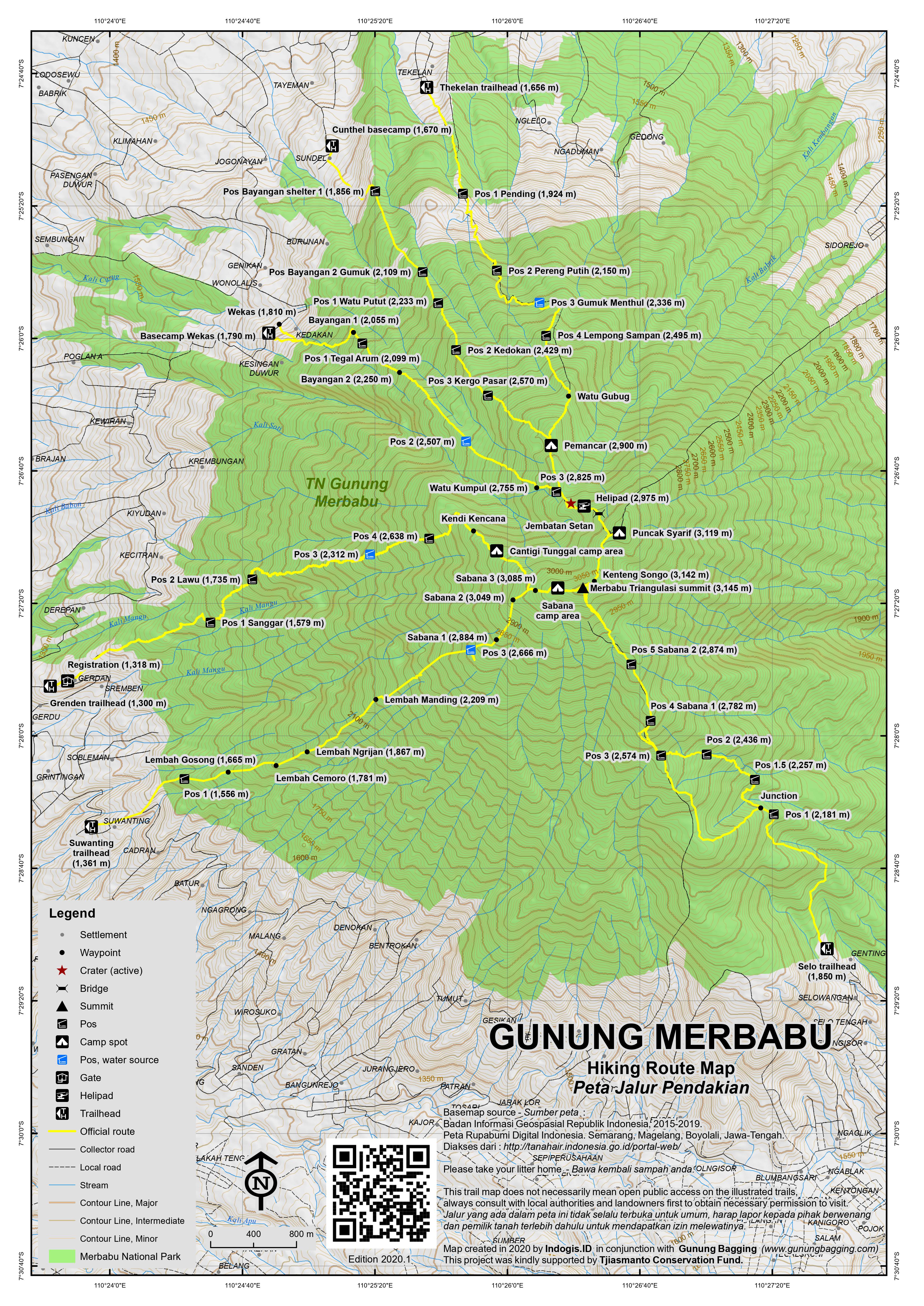
The starting point closest to Kopeng is Thekelan village (1,656m elevation), where you are requested to register at the tiny National Park Office. It is a long 6 to 8 hours up to the summit and you will need a sunhat and sunscreen as most of the trail is not forested. This has an upside of course – views are breathtaking, particular towards Sindoro and Sumbing.
There are 4 “pos” or shelters: 1) Pending (1,924m); 2) Pereng Putih (2,150m); Gumuk Menthul (2,336m) where there is a water source; and Lempong Sampan (2,495m). Strong hikers should take no more than 2 hours to reach Pos 4, but your porters may need longer. After the 4 pos, there are the seven summits. The first is Watu Gubug (2,735m) and the second is more obvious and called Watu Tulis or Pemancar or Menara (‘tower’ in English) (2,900m) where there is an old radio mast. It should take strong hikers no more 3 hours to get to this point.It is also where you meet the trail to/from Cunthel.
After Watu Tulis/Menara/Pemancar, the path drops down a little to Batas Kabupaten (2,825m) – a short cement pillar marking district boundaries also known as Pos 3 Wekas. Here you meet the path coming up from the third northern route, Wekas. Just before the climb starts to Summit 3, there is a possible source of water near to an obvious crater area – a large outcrop of white/yellow sulphurous clay soil. You are likely to be able to smell sulphur in the air. You drop down an obvious path to the right and if you are lucky can hear the stream below very clearly. This area is a popular camping spot for those who do not want to hike all the way to the summits over 3,000m. If you do camp here, it means an early morning start if you want to get to the summits for sunrise, and you’ll miss the best views of the sunset.
Continuing along the ridge, the climb starts to Summit 3 via a flat area known as Helipad (2,975m) where there is a prominent memorial. To the right is an attractive minor summit called Gunung Kukusan, which strangely is not included in the ‘seven summits’ list. Summit 3 is Geger Sapi (2,987m) is not really much of a summit, and is more of a small hump on the fairly relentless steep climb towards Summit 4. This section is known as Jembatan Setan (Devil’s Bridge) and offers great views back down to the north – from some angles the range resembles Machu Picchu.
As you reach the summit ridge (3,080m), you can turn left to climb the last few metres (i.e less than ten minutes) to Summit 4, Puncak Syarif (3,119m). This is a fabulous camping spot, with views of Sumbing, Sindoro, Merbabu’s highest summits and Merapi. There are surprisingly many good flat camping areas, and you may well have the whole of Puncak Syarif to yourself, until the sunrise hikers make their way up from Summit 3.
Another good camping spot is Summit 6, which is near the true summit and called Kenteng Songo (3,142m). To reach Summit 6 from Summit 4, you drop back down and hike along the ridge between the summits. The path actually passes around the south-east side of Summit 5, Ondo Rante (3,100m), before the final steep climb to reach Summit 6. Both Ondo Rante and the steep scramble beneath Kenteng Songo are a little challenging, but whereas Ondo Rante can be avoided, if you want to bag Merbabu from this side you will need to take great care ascending a steep, rocky section of cliff then scree with a little bit of exposure.
Kenteng Songo has numerous signs at the top and seems to be the most popular of all the tops, especially at sunrise during weekends, when many hikers head up from Selo. Most of interesting of all are the ancient-looking stone jars at the top which look like miniature versions of Laos’ famous stone jars near Phonsavan. A short hop from Summit 6 is Summit 7 – Triangulasi – which appropriately has a pile of stones and a blue cement rock at the very highest point (3,145m). Triangulasi is the true summit of Gunung Merbabu, being three metres higher than Kenteng Songo.
All three of the main campsite areas offer wonderful views eastwards to Gunung Lawu, northwards to Telomoyo and Ungaran and south to Gunung Merapi, but the highest peak is definitely the best for watching Merapi.
Dscent to Selo (the village nestling between Merbabu and Merapi)
The trail leads down from both Triangulasi and Kenteng Songo. This will take at least 4 hours and is hard on the knees. It passes through Jemblongan, Pos 5 Savana 2 (2,874m) and Pos 4 Savana 1 (2,782m), all of which are very popular with campers.
After the steepest part of the descent, the trail divides at Pos 3 (2,574m). The left (more easterly) option is a better choice. It leads down through some open forest that becomes a denser as you descend further via Pos 2 (1,436m), Pos 1.5 (2,257m) and Pos 1 (2,181m) before which the alternative route meets the main trail. Soon you’ll reach some pine plantation and suddenly see the village that marks your exit from Merbabu National Park, and the end of a fantastic hike. The Selo trailhead is at 1,850m.
The Cunthel trail: The basecamp is at 1,670m. Walk through the friendly village and up the cement track which ends at 1,770m. The trail initially leads through pleasant forest and has several posts as follows…. Bayangan 1 (1,856m) where there is a decent shelter, Bayangan 2 Gumuk (2,109m), Pos 1 Watu Putut (2,233m), Pos 3 Kedokan (2,429m), Pos 3 Kergo Pasar (2,570m). It should take no more than 3 hours to reach Menara where you meet the trail from Thekalan. This trail is a good option to head down on if you are descending back to the north (i.e towards Salatiga and Semarang).
The Wekas trail: The basecamp is at 1,790m making this friendly village a very attractive starting point and perhaps better than Thekelan. Following a thin white water pipe for a considerable amount of time, the trail leads up past a grave (1,885m), Bayangan 1 (2,055m), Pos 1 Tegal Arum (2,099m), Bayangan 2 (2,250m), Pos 2 Wekas (2,507m) which is a large flattish area popular with campers, Watu Kumpul (2,755m) near an obvious crater area, Pos 3 Wekas (2,825m) which is just before Batas Kabupaten (2,825m) which is on the Thekelan and Cunthel routes too. Strong hikers can reach this point in under 4 hours.
The Suwanting trail: The trailhead is at 1,361m and the trail leads via Pos 1 (1,556m), Lembah Gosong (1,665m), Lembah Cemoro (1,781m), Lembah Ngrijan (1,867m), Lembah Manding (2,209m), Pos 3 (2,666m), Sabana 1 (2,884m), Sabana 2 (3,049m), Sabana 3 (3,085m) before reaching the Sabana camp area just west of Triangulasi summit. Like the Selo approach there are great views to Merapi on this trail.
The Grenden trail: The trail starts at around 1,300m and leads via Pos 1 Sanggar (1,579m), Pos 2 Lawu (1,735m), Pos 3 (2,312m), Pos 4 (2,368m), Kendi Kencana, Cantigi Tunggal which is popular for camping, before meeting the Suwanting trail near Sabana 3 Suwanting.
Bagging information by Andy Dean and Daniel Quinn (last updated in May 2020).
Trail Map
For a high quality PDF version of this and other trail maps, please download from our Trail Maps page.
Featured Guides
- Name and location: Adi, Selo, Central Java.
- Contact details: +6285600345758, Adi.alesana10@gmail.com, https://www.instagram.com/adi_merapi/
- Review from previous client: “I had the pleasure of embarking on Merbabu mountain adventure led by Adi in 2017 and I cannot speak highly enough of the experience. From start to finish, Adi demonstrated exceptional expertise, professionalism, and a deep passion for the mountains.” K Thi, USA.
- Name and location: Sura Mendhol, Selo, Central Java.
- Contact details: +6281548615234, suramindhol507@gmail.com
- Review from previous client: “My guide was Sura Mendhol, he was already mentioned by another person here. He is very experienced (having lived between the mountains all his life) and his English is good, so I can recommend him.” Jari, Austria.
Practicalities
- Getting there: For domestic flights from or to Central Java, such as the airports in Semarang, Solo (Surakarta) and Yogyakarta/Jogjakarta we recommend Baolau. There are plenty of flights and train services from Jakarta to Semarang, Jogja and Solo. From there, public transport is available to all starting points but it will take much longer than if you can arrange your own transport.
- Guides and GPS Tracks: Want a PDF version for your phone? Looking for a guide? Need GPS tracks and waypoints? Gunung Merbabu information pack can be downloaded here.
- Trip planning assistance: Would you like Gunung Bagging to personally help you in arranging your whole trip? Please contact us here.
- Permits: Register at one of the basecamps and pay the small entry fee. Take a photocopy of your passport photo page with you.
- Water sources: Available at Pos 2 on the Wekas route. Supplies usually available at Gemuk Menthul (2,330m) and sometimes between Watu Tulis (2,900m) and Summit 3 on the Thekelan route. Usually available at Pos 3 on the Suwanting route and Pos 3 on the Grenden route.
- Accommodation: Try the Booking.com map above or use this link to search for suitable hotels, homestays, resorts and apartments for your trip.
- We recommend Safety Wing as travel insurance for overseas travellers and tourists hiking up to elevations not exceeding 4500 metres.
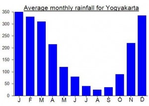
Local Average Monthly Rainfall (mm):
Location
Click on the blue arrow ![]() (top right) to see your current location on the map
(top right) to see your current location on the map
Origins and Meaning
Ashy Mountain. The name Merbabu probably evolved from merabu or merawu which consists of the prefix mer– and the base word abu or awu. Mer– (same as the Indonesian-Malay ber-) means “to have/possess the quality expressed in the base word”, and abu / awu means “ash”. So Merbabu means “the ashy one” referring to ash expelled during the mountain’s incessant eruptions. Merbabu hasn’t erupted in recent historical times, but the name Mount Ashy may represent a memory of the mountain that goes back well beyond recorded history. See also Mount Lawu. (George Quinn, 2011)
Climbed with Sura in May 2026. 4 hours up. Sumitted at 4:30am.
Was a great experience and highly recommend Sura, he’s excellent
https://www.instagram.com/suramendhol_guidemerapimerbabu
3 of is chose to go with Adi after a recommendation from friend. We were not disappointed.
The whole thing is extremely well organised and executed beautifully. Seamless. Picked up at pur hotel in Yogyakarta, brefing at Adi’s house that sits below the volcano. After the brief and coffee we stated the trek.
On the trek Adi was brilliant, adjusted the speed perfectly. Didn’t rush but we also made great progress. He knew the best routes up the mountain.
When we arrived at base camp 4 we arrived to our tents already set up with table and chairs set out under a cover for an outside seating area. (Thanks to the porter who carried all the gear up ahead of us to set up) Beautifully done. Hot tea and a snack before a genuinely delicious dinner cooked by the team.
After a VERY COLD nights sleep we set off at 4am to peak the summit for sunrise. Adi knew all the nest photo spots at the top and took some amazing pictures of us all at the top. He gave us as long as we wanted to at the top and didn’t rush us at all.
The way down was dusty, steep, but stunning.
They dropped us back in Yogyakarta after.
Overall a 10/10 experience.
You can do it cheaper, but in this case you definitely get what you pay for. Worth every penny.
Whatshap +6285600345758
Adi_merapi in instagram
My friend and I booked Sura as our guide, and it was amazing experience!
We arrived at his house at around midnight.
Sura has been guiding at the volcano since 2007, and it really show in how smothly and chalmy he organized everything.
Before hike, Sura clearly explained the procedures, the gear we need, and the important rules to follow.
Sura also provided hiking stick headlamps, Which was super help full.
We start the climb at around 00.30.
Sura always adjusted to our pace, he often Suggested taking break and even shared some breathing techniques that made the hike comfortable.
We reached the summit around 5.30, just as the Eastern sky was turning red.
Sura made us hot tea and coffee and even cooked some warm noodle soup. it was perfect!
We highly recommend Sura! He’s kind and friendly, he also very knowledgeable about nature, especially his home mountain : Merapi and Merbabu.
You can contact Sura through this link :
WhatsApp: https//:wa.me/+6281548615234
Instagram: https://www.instagram.com/suramendhol_guidemerapimerbabu?igsh=MWg3b3k0a3EybnVuOA==
Email :
suramindhol507@gmail.com
I did the Merbabu summit sunrise hike a few days after it opened for the season, early March ’26. Adi was our hired guide, he was a great choice. He grew up and still lives nearby, ou could tell how well he knew the mountain and how long he had been a guide. He paced the hike well, taking time for breaks and slowing down in the more challenging parts of the ascent. I wasn’t expecting him to have hot coffee for me at the summit, that was a nice surprise for sunrise!
It is definitely a challenging hike, especially on little to no sleep. We left Yogyakarta at 10pm to hit the trail at 1am to summit by 5:30am. Definitely worth it!
If I come back to this region, I’ll definitely look up Adi as a guide for some of the other mountain hikes nearby.
His contact:
Whatsapp +62 856-0034-5758
Instagram https://www.instagram.com/adi_merapi?igsh=MzRlODBiNWFlZA==
J’ai passé une des plus belles expériences de la vie et c’est en partie grâce à Adi.
Je recommande l’expérience qui peut se faire en 1 ou 2 jours pour la vie incroyable, le dépassement de soi et aussi, mais surtout la rencontre d’Adi qui est une personne incroyable.
À bientôt Adi, c’est promis!
We highly recommend Sura as a guide, he is very experienced. He explains everything from a-z about climbing Merbabu safely and comfortably.
Sura knows a lot about flora and fauna, he is also funny. We laughed throughout the trip. Merbabu is very beautiful, the dusty road is a little slippery at this season.
we climbed for 4,5 hours to reach the top in total, and descend longer because the flora and fauna were too interesting to miss.
The headlamp and hiking stick provided by Sura were very helpful.
Sura said there are several illegal routes on Merbabu, make sure you are on the official route, register online and have ETicket.
Sura helped everything well, just climb with your eyes closed.
this is his Instagram
https://www.instagram.com/suramendhol_guidemerapimerbabu?igsh=MXVxYmswdzFrYTl2Zw==
WhatsApp : +6281548615234