Facts
- Elevation: 800 m (2,625 ft)
- Prominence: 800 m
- Ribu category: Spesial
- Province: Sulawesi Utara (North Sulawesi)
- Google Earth: kml
- Rating:


 (5 votes) Add your rating
 Loading...
 - Other names: none.
Photos


Bagging It!
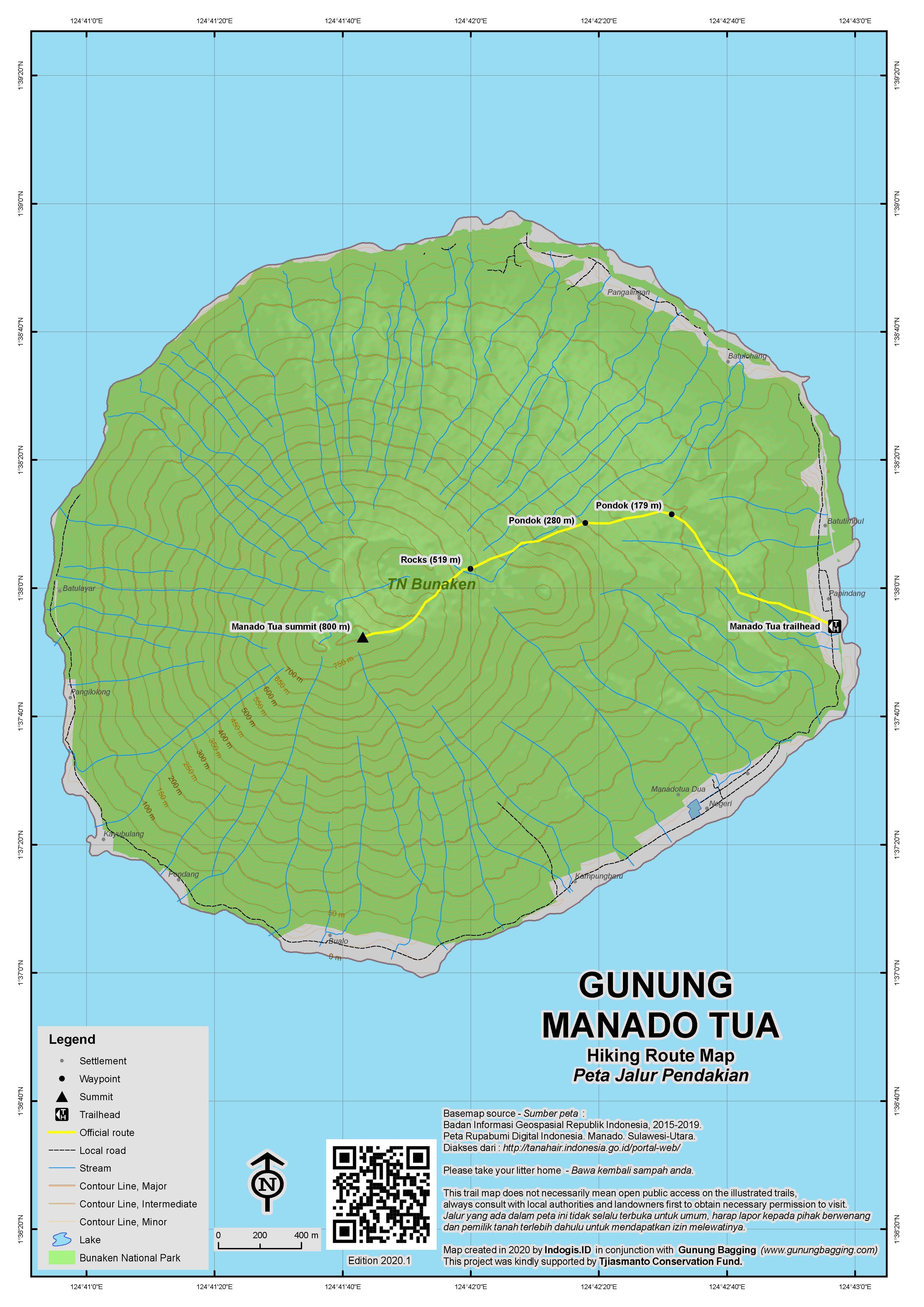
Manado Tua is an inactive volcanic cone island off the west coast of North Sulawesi, close to the capital Manado. There is a good path to the top and the summit offers great views over the other islands and Manado Bay. In good weather you can see the smoking cone of Gunung Soputan almost 60 kilometres away. But be careful you don’t fall into the huge hole at the summit which was made recently by local people looking for buried treasure!
It is not difficult to arrange a day trip to the island from Manado – motor boats take approximately one hour to cover the 10 miles distance. However, while you’re in the area you might as well stay on the delightful neighbouring resort island of Bunaken, one of Indonesia’s diving and snorkeling hotspots.
From Bunaken it is about 30 minutes by boat to the village of Papindang on Manado Tua. You should be able to charter a boat from Bunaken to take you there and then back to Manado city afterwards for a total of 1 million rupiah or less (including a guide fee of around Rp200,000). It is best to set out as early as possible from Bunaken (5am perhaps) to beat the worst of the heat and enjoy the spectacular dawn views of North Sulawesi’s volcanoes and islands. The climb starts at sea level so suncream, hats and lots of water are required. The handful of locals that regularly ascend the peak claim it takes them just over an hour. For most people carrying a backpack of food and drinks with them it will take a minimum of two hours to get to the top.
The trail starts behind the village houses, where a guide can be found, and leads up through coconut plantations. Several huts are to be found on the trail which are ideal for getting a bit of proper shade. The trail even leads right through one of the huts near the beginning. There are some pleasant views of low-lying neighbouring islands halfway up and after about 90 minutes you should have reach the rim which is at about 610 metres high. Take a left here and follow the path straight up for a further 30 minutes to the flat summit.
The first thing you will notice at the summit is the cement pillar which is leaning to one side. Next to it is a deep hole which looks like a well. Take real care here because you would have real difficulty getting back out of this hole should you fall in and chances are you would be seriously injured. This hole is not a well, but a man-made pit, created recently by local villagers and others from Manado city alike, who were for some bizarre reason convinced that there was buried treasure to be found at the peak of the island which had been left there in Dutch colonial times. According to locals it took quite a while to dig such a deep hole (it is perhaps 15 or 20 metres deep or more) and police from the mainland were eventually called. Needless to say, no treasure was found.
There is also a small monument marking the planting of a Matoa tree at the summit. Matoa is a delicious fruit common in Eastern Indonesia. Better still is the view on a clear day which, though limited by trees in most directions, offers splendid panoramas of Manado city and Lokon and Soputan volcanoes. You can just about make out Klabat through the trees too.
It takes just over an hour to descend and it is much easier with gloves and a stick on what can be very slippery terrain after rain. After admiring the island’s churches and chatting with the friendly locals you can either head back to Bunaken or ask your boatman to take you direct to Manado.
Bagging information by Dan Quinn (November 2012)
Trail Map
For a high quality PDF version of this and other trail maps, please download from our Trail Maps page.
Local Accommodation
Practicalities
- Getting there: To get over to Bunaken you can either charter a boat from Manado for between Rp150,000 and 300,000 or wait for the public boat which leaves every day (except Sunday) at between 2 and 3pm. Be warned that some resorts refuse to accept non-divers because they are less profitable.
- Guides and GPS Tracks: Want a PDF version for your phone? Looking for a guide? Need GPS tracks and waypoints? Manado Tua information pack can be downloaded here.
- Trip planning assistance: Would you like Gunung Bagging to personally help you in arranging your whole trip? Please contact us here.
- Permits: You are supposed to pay a fee of Rp50,000 per day when on Bunaken and neighbouring islands (or Rp150,000 for a year). This is supposedly used for conservation efforts.
- Water sources: None available.
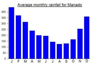
Local Average Monthly Rainfall (mm):
Location
Origins and Meaning
Literally old Manado. It may effectively mean something similar to ‘the old man of Manado’.
Read Rob W’s trip report for Manado Tua here: https://www.peakbagger.com/climber/ascent.aspx?aid=2068664
I was in Bunaken island from Nov. 1-4 scuba diving while staying at Bunaken Island Resort. I wanted to climb Manado Tua as it’s nearby and accessible but I couldn’t find the time or the opportunity. It rained on three days of the four days I was there and I was told the trails would be especially muddy. I did dive, however, just in front of the main town with the church. That was one of the most challenging dives I’ve done because of the strong currents. It was not only horizontal currents, there were also downcurrents and upcurrents. And getting back on board the dive boat was also difficult because of the swells. Next time!
I got a very reasonably-priced boat over from Manado to Bunaken…. bargained down from 300,000 to 150,000. Not bad for my own private boat, even if the motor did break down a few times. Be prepared to wade through the sea for 20 metres or so when they drop you off as most of the smaller vessels cannot dock when the tide is low.
After an afternoon of sampling Cap Tikus and Selera Sari (local alcohol – be careful with this, too much and you could go blind or die) and playing around on a local double bass-type instrument I got an ojek round to Liang beach and Alung Banua pier for a few photos of Manado Tua from Bunaken.
Captain Opo met me later on and agreed to pick me up at 5am the following day for the trip to Manado Tua. The dawn was quite beautiful and given that rain had fallen overnight the views to distant mountains were pretty extensive from the boat.
On arrival at the Christian-only island itself I was greeted by a pleasant woman whose uncle normally leads tourists up to the top. He wasn’t around so another guy was out in a flash with his machete and water bottle and off we went. He reckoned just over an hour to the top. For an ascent of over 800 metres that would be pretty impressive. In the end it took us 2 hours as he waited for the sweating white man with the rucksack full of water bottles.
As with most of the peaks of lower elevation on Indonesia, this hike starts near sea level and is a serious workout for those of us with pale skin unaccustomed to the tropics. The local guide drank just 1 small bottle of water while I got through 3.
Was pleasantly surprised with the view of distant mountains, though I was expecting more notable evidence of an old crater. The pit dug by mad locals is genuinely dangerous – watch out at the top.
Not only is Manado Tua a decent early morning hike in itself, but is is also a good excuse to visit Bunaken for those of us who don’t do much diving or snorkeling. It cost a million for the boat to Manadotua and then back to Manado itself and this included the guide fee of 200,000. Not bad really, especially if you are in a group of 3 or 4.
The only unpleasantness comes at the end when you (probably) have to wade through the filthy water at Manado pier. There is a mandi where you can wash your legs afterwards near the pier but it takes a bit of courage to step out of the boat into what really is utterly disgusting water. Locals seem to think nothing of it but the authorities really could do with sorting the place out as it projects exactly the opposite image of the one they want to project for Bunaken. So remember some flip flops for this possibility as you really don’t know what you might be standing on otherwise.