Facts
- Elevation: 1,038 m (3,406 ft)
- Prominence: 1,038 m
- Ribu category: Kurang Tinggi
- Province: Peninsular Malaysia
- Malaysian state: Pahang
- Google Earth: kml
- Rating:


 (5 votes) Add your rating
 Loading...
 - Other names: none.
Photos


Bagging It!
Tioman is the only significantly mountainous island of several scattered off Peninsular Malaysia’s east coast. Despite being a popular holiday island, the forest remains very wild and is home to some endemic species.
Most visitors to Tioman get their first view of the island’s peaks from the boat over from Mersing. The extinct volcano of Gunung Kajang is easily the highest, yet the most dramatic peaks are near-vertical granite cliffs to the south of the island known as the Dragon’s Horns. These are Batu Sirau (747m) and Nenek Si Mukut (685m) – and are of real interest to rock climbers.
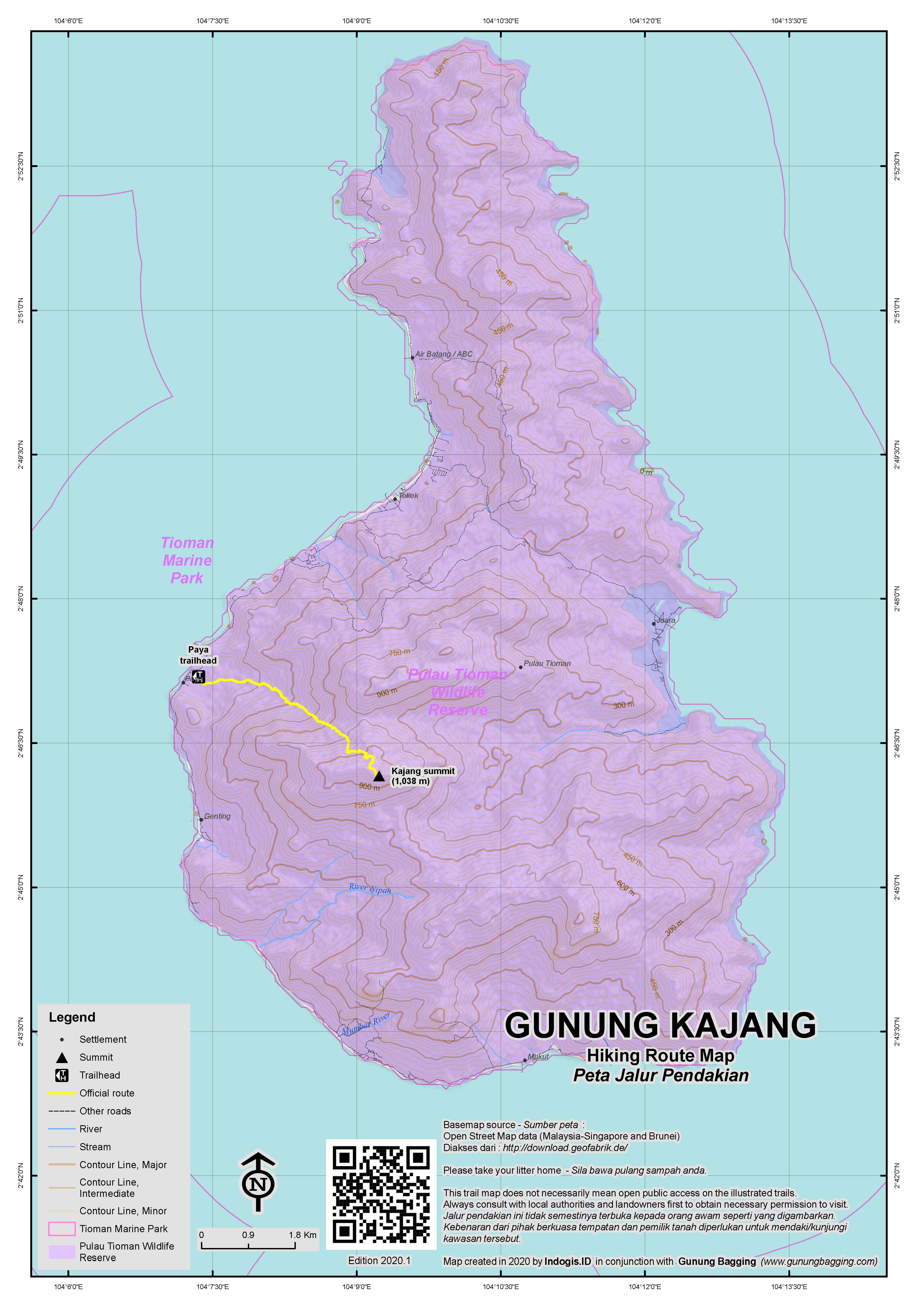
Gunung Kajang itself is less impressive when first seen on approach to Genting and Paya, an unassuming high jungle-clad ridge that not many pay much attention to after having seen the Dragon’s Horns. Most hikers start early and do this as a long day-hike, but camping at the summit is apparently also possible. Be aware that Tioman’s forests are full of leeches, so leech socks are recommended. Also note that there are very few panoramic views on the trek and local guide prices tend to be sky-high, even by Malaysian standards.
The most commonly-used trail starts in Kampung Paya and how long it takes to reach the top from there depends entirely on how recently anyone else has been up there. If you’re lucky, and another group has been up in recent weeks, it takes around 5 hours to reach the peak. If nobody has been there for over a year then the trail will be incredibly hard to see for much of the way and it could take 7 or more hours (one-way). So it is crucial to find out the state of the trail from a local guide first before making any assumptions. It is also vital to start very early, before first light, regardless of what your guide suggests. Otherwise you may end up coming down in the dark, through what is tough terrain to navigate at the best of times.
There are various trails criss-crossing each other behind the Paya village resorts, some of which are used as an ATV track. The first major landmark is ‘Mother Willow’ (90m), an impressive old willow tree that some adventurous families trek up to in about 30 minutes from the beach. Mother Willow is signposted, but beyond the old tree there is very little to go on aside from a few yellow daubs of paint on branches and some ropes on the higher slopes. Therefore an experienced guide is completely essential.
The birdlife here is excellent and there is also a good chance of spotting mouse-deer (‘kancil’). If you are extremely lucky and here at the right time you might come across Rafflesia tiomanensis. After a dry stream crossing (224m – not dry during the rainy season), there are two reliable ‘water points’ on the trail at 299m and 627m. The steep terrain between these two streams is challenging, and often overgrown. Beyond the second water point, the trail appears a little clearer with some impressive large boulders passed by (636m and 820m).
And then comes the most challenging section of all, a large cluster of giant boulders (850m) with ropes showing the way over narrow ledges and between considerable drops. A fall here could easily lead to hospitalization and so extreme care needs to be taken. At one point you need to drop down through a hole in the ground before clambering over several boulders with deep dark crevices on either side.
Once past this challenging section, it is a fairly easy 30-45 minutes up to the summit where there is a metal pyramid structure (beirut) as commonly found on Malaysia’s mountain-tops. The views are limited due to the density of the vegetation, but if you have made it here then you deserve a pat on the back!
Assume about 4-5 hours back down to Paya beach, but allow extra so that you don’t arrive in the dark.
Apparently, there is another vague trail up from Kampung Juara on the east coast of the island. However, it is much less well-used and if starting in the morning then you may have the sun on your backs – one advantage to starting in the west at Paya. The one appealling thing about the Juara trail is the presumed easier terrain as you would not need to navigate the dangerous boulders encountered on the Paya trail.
As for the Dragon’s Horns, a short, decent, and sign-posted trail leads part of the way up to a great viewpoint beneath the cliffs (at Checkpoint 9), looking back down to the ocean. The trail starts in Kampung Mukut where there is some accommodation. Unfortunately the regular boats do not call at Mukut so you would need to charter your own or trek along the coast from further north, assuming it is possible to do so.
Bagging report by Dan Quinn, May 2022.
Trail Map
For a high quality PDF version of this and other trail maps, please download from our Trail Maps page.
Local Accommodation
Featured Guides
If you are a reliable local guide and would like to be featured on this page to increase your bookings, or a tourist who would like to support the development of a local guide business, please email danpquinn@gmail.com with the following information: Mountain name, guide name, guide location, guide contact details, and at least one English language review from a previous hiker who was pleased with the guiding services. An example is given below for reference. We have a maximum quota of 3 featured guides for each mountain page on the site. The fee for this is £20 (British pounds sterling, typically via the Wise app or PayPal) for a period of 1 year and helps to pay towards the ongoing development of the Gunung Bagging project.
- Name and location: Pak Budi, Surabaya, East Java.
- Contact details: +62812xxxxxxxx, budi@gmail.com, https://www.instagram.com/budi_mountain_guide/
- Review from previous client: “Budi was a brilliant guide for our September 2023 trek up Gunung X and I would definitely recommend him to other tourists“, John, USA.
Practicalities
- Getting there: The closest major airport is in Johor Bahru but many folk come from Singapore and KL too. Most people take the ferry from Mersing to Tioman (which takes just under 2 hours), but Tanjung Gemok (40km further north) is an alternative and increasingly popular option as it is not as reliant on the tides. Ferries from both ports call at several key villages on the west coast of the island, usually from south to north i.e. Kampung Genting, Kampung Paya, Tetek, Air Batang and Salang. The basic return ticket costs around RM100 and there are usually a minimum of 2 crossings per day, but book ahead during the holiday season. There is also an airport on the island with occasional flights from KL though these seem to have been unavailable to the general public since 2014.
- Guides and GPS Tracks: Want a PDF version for your phone? Looking for a guide? Need GPS tracks and waypoints? Gunung Kajang information pack can be downloaded here.
- Trip planning assistance: Would you like Gunung Bagging to personally help you in arranging your whole trip? Please contact us here.
- Permits: There is a Marine fee (RM30 for foreigners and RM5 for Malaysians) that all visitors must pay at the ferry terminals. Plus a Tioman island fee (RM3) to be paid at your accommodation. As of 2022, there is no specific permit required for the actual hike itself, though this could easily change with little warning.
- Water sources: Available at Water Point 1 (299m) and Water Point 2 (627m) on the Paya trail.
Local Average Monthly Rainfall
Hi Dan, I found your article in my preparations to climb Gunung Kajang again end of October 2022. This climb is to straddle Gunung Kajang from Juara to Paya.
I last climbed G. Kajang in 2012, 2013 & 2014. Should you need more information about my previous climbs do contact me.
My first climb In 2012, was with another buddy without a guide. This was my survey of Kajang. We spent 2 nights in the mountains. 2nd night was spent literally descending the waterfall at night. Slept on the dry waterfall boulders. Made it back only at daybreak. We spent 68 hours exploring the Jungles day and night.
In 2013 & 2014 climbs were rediscovering these Trails.
End Oct 2022 is to straddle Tioman from Juara to Paya.
Now doing my preparations for the October climb.
I gave Gunung Kajang a try last week. It ended in failure, for various reasons, but we weren’t too far from the top when we had to head back down. The island itself – which features in the 1958 film South Pacific – was well worth visiting for a couple of days.
Getting to the island was quite an adventure in itself, with the 4am bus from Sentral not showing up until 0445 and even then not in a place you might expect (the rear entrance to Sentral). The bus then spent ages going round in circles near TBS (Terminal Bersepadu Selatan). The official arrival time of 0949 (just short of 6 hours from KL) was way out, with us arriving at Mersing at 1145. Nearly 8 hours. So, always plan for this and never book a boat ticket for too soon after you are scheduled to arrive.
The boat over was fairly good with a window seat and an excellent view to Johor’s Pulau Tinggi, a very sharp peak island of around 609m elevation. And then Tioman itself came into view, with the Dragon’s Horns and then the most low-key Gunung Kajang. The boat was completely packed with tourists, many from Singapore and both Genting and Paya are lovely places to relax for a few days with sunset views over the ocean.
Most folk are here for diving or just relaxing and almost nobody is here for Gunung Kajang. That, along with the SIngapore clientele has led to some eye-watering prices being quoted for a day-hike in the forests. The only obvious guide on the island – Lambak – at first suggested RM250. And indeed RM250 is the going rate for much of Malaysia. But, here was the catch, it was RM250 per person, a minimum of 6. That’s RM1500, a basic monthly wage for many in Malaysia. For a day-hike.
I managed to get him down to RM500, still a very high price for a forest trek, especially when you are alone. If it’s a group of 6 from Singapore then doable. But for one person it’s quite a sum. I agreed to it as it had been on my list for so long, but I expected a much better result than what actually happened.
He said start at 8am. A bit on the late side for me, as I always like to get started by sunrise at the latest to make the most of the daylight, especially on a trek which is not well-known. But I agreed to 8am, assuming he thought that sort of starting time would be suitable. And when I showed up, it turned out there would be 4 of us. Lambak, his friend (another guide), and a Malay girl. Not what I was expecting, but not much point wasting time on debating matters. I presumed that the girl was perhaps the wife of Lambak’s friend or at least a local to the island who knew what the trek might entail.
The trek started well, and we saw a few mouse-deer. But it soon became apparent that Lambak’s friend and the girl were having real trouble keeping up with me and Lambak. And then it was discovered that the girl had never hiked a mountain before. Kajang is not a suitable place to learn, unfortunately, and the two of them were slowing us down. I made numerous comments about us having to turn back around 1pm, but it did little good and Lambak didn’t seem to want to leave the other 2 behind, especially as we were having difficulty locating the trail beyond the first water point. And all this, presumably, to make a bit of extra money.
After the second water point even Lambak was looking a bit exhausted, but I tried to encourage him to make good time as it was after 1pm already. We met a lot of leeches on the trail, to the extent I stopped caring, and just ploughed ahead. But the terrain itself was not easy at all. The other 2 were way behind, not answering our shouts, and then we got to the really rather dangerous boulder section with ropes. Some of these ropes may have been good in the past but one or two of the branches they were tied to had since died meaning a bit of extra added danger. The authorities really could make this a great hike, but this spot needs a bit of extra safety measures putting in place to lessen the risk. Lambak videoed me going over the tough bits. I wondered… was this for fun or as documentation for if I fell in and needed to be stretchered out? Perhaps both!
It was approaching 2pm as we got to the end of the tough section. And at the end of the tough section, the trail was totally covered with fallen tree branches, meaning from there to the summit would not be 30-45 minutes but at least an hour. This is dangerous terrain even in daylight, and we had the other 2 lower down, and I had promised I’d be back in Paya for an evening meal. So reluctantly we turned back at just after 2pm.
He told me a few folk had fallen down the holes between the boulders, that one group had not made it back down until midnight, and that once he himself had become lost and only arrived back at Paya at 5am. This is not easy terrain.
Back at the second water point, Lambak’s mate said ‘not possible, yeah’ to me, to which I angrily replied ‘perfectly possible, but not enough time!’ Had the other two not been with us, we would have made it. Had we started at 7am, we would have made it down before dark. But as it was, we started too late, the trail was incredibly overgrown, and 2 hikers were going too slow. One great way of knowing the difference between a good guide and a bad one is by asking yourself whether he is going at your pace or you are having to go at his. An even more obvious way is by asking yourself if he has invited someone else along to make an extra buck at the expense of going at your pace and reaching your target.
It was too late to make any difference, but on the way down we did split up, the two of us going ahead of the slower two. Lambak said he would have to come back to look for them if they weren’t down by dark, as if it was somehow actually my fault for inviting them along. Me and Lambak made it down to the village quickly, perhaps in 3 hours, charging ahead, seeing a pretty big monitor lizard (‘biawak’) at least a couple of hundred metres up the mountainside. I told him I was very disappointed after having paid a very high fee RM500 to not reach the target because of the others. He didn’t offer an apology and said RM500 was ‘normal price’ in Tioman. Well, I am 100% sure that the Malay girl didn’t pay anything like RM500, perhaps RM100 at most, and thanks to that, I didn’t manage to bag Kajang. Incredibly bad manners of them to invite someone else along, especially someone who was not experienced, just to make a bit of extra cash, as that ultimately destroyed my chance to bag Kajang.
Note also that Tioman’s forests have some sad tales attached to them, including the extremely sad and extremely mysterious death of a British guy who had been volunteering at the turtle conservation place over on Juara and went hiking near the waterfall on Kajang’s eastern slopes. Like for many of these ‘tourist party islands’ in Southeast Asia, I wouldn’t recommend being out in the middle of the forest after dark.
The guides may be ridiculously over-priced here, but the silver lining on Tioman is that the beer is cheap.
The next day, the boat ride back over to Mersing was uneventful. We walked across to the bus terminal (10 minutes from the ferry terminal) and got the ancient-looking yellow bus over to Kluang (2 hours, a bargain 9 ringgit each).
Anyone interested in knowing more about the Dragon’s Horns can have a read here…. https://www.planetmountain.com/en/news/climbing/damai-sentosa-new-route-on-dragons-horns-in-malaysia.html
Enjoyed reading your write up on Gunung Kajang. I feel sorry for you on the whole experience. U said Lambak is the only guide on the island?
Hi Jay.
I think it depends how long you have on the island. If you are there for 2 weeks then you have enough time to ask around and perhaps find someone else or negotiate a lower price and strict terms and starting early and so on. If you only have 2 or 3 days then you should probably try to get a guide arranged in advance, because even if you do find someone then they might be busy that week. Lambak is the obvious choice as he is experienced. But the price is quite high and obviously you may end up in a situation like I did. Also, please do take special care near the top as the gaps between the boulders are huge. With a bit of work (trail clearing, ropes, ladders) from the local authorities, this could be a great hike, but at present it is expensive and potentially dangerous. I wish you good luck and would love to hear how you get on.
Hi Dan, me and 2 others hiked up Gunung Kajang on the 28 Oct 2022. We camped out 3 rainny nights in the forest. Our hike ended at 2300hrs on the 31 Oct 2022.
It was a real wilderness hike. This is my fourth climb via Paya. My Descend to Juara was aborted due to it being unfamiliar and having to tracking through darkness.
We will be going up Tioman again next year during the Labour Day Holiday. Will start climb via the Juara Route in the East to Kajang and may descent to Nipah on the South.
Tioman is an Extinct Ancient Volcano. This discovery made my fouth climb more exciting. Got a better grasp of the geology and rock formation there. The geology is unbelievable, unlike other mountains I had climb.
Pls contact me if you want to do G Kajang again. Go via Juara. There are guides from there.
Congratulations. Yes, perhaps one day I will return and try the Juara route…..
After 3 pleasant weeks of summer holiday in the UK completing the list of Welsh Marilyns with no problems whatsoever it was back to Southeast Asia yesterday and a return to complete ineptitude and chaos due to unprofessionalism and breaches of basic consumer trust!
I had just enough time to fit in one more hiking trip before having to be back at work, and months ago I’d decided on Gunung Kajang because a dayhike of a new Ribu with some time for relaxing by the coast seemed ideal. After Rob’s reports of serious delays with immigration to/from Singapore/Malaysia at the Johor end, I decided on flying to Johor itself to minimise the likelihood of travel disruption. If anything, what actually happened was far worse than had I just gone via Singapore.
After painstakingly booking flights, buses, ferries, and sorting out a local guide, everything on my side was ready to go, planned to perfection, and with enough leeway given for a 90min flight or ferry delay at either end. I went to Soekarno Hatta as usual, checked in and only upon reading the boarding time for the second leg (KL to Johor Bahru) did I notice anything was up. Indeed, the Malindo staff member had said nothing about the ‘retiming’ of the flight or the ongoing technological chaos at KLIA that I was unaware of. The second flight was changed to depart 2hr 15min later than the original schedule, meaning my already paid for bus connection in Johor would be missed.
No email had been sent, no Traveloka message, nothing. And even at check in the staff did not draw my attention to this. As I was looking for alternatives with other airlines (none available!) a succession of three messages from Traveloka suddenly arrived, the first stating the change I was now aware of, the second stating a slight improvement but departing 50km away at Subang Airport in the centre of KL (!), and the third stating a further delay and also from Subang and not KLIA.
I thought about either getting a bus from KL to Tanjung Gemok (ferry terminal for Tioman) or a later bus from Johor Bahru, but the former were unavailable at such short notice and there was only one later bus leaving Johor Bahru at 1945. To cut a long and tedious story a little shorter, I decided not to risk throwing even more money down the drain by booking the later Johor Bahru to Mersing / Tj Gemok as it would require the delayed flight to be perfectly on time for it to be doable and it was clear from checking online news that KLIA was in meltdown with 68 flights cancelled or delayed due to an IT problem. As Malindo would not pay for me to get a taxi to make my onward connections, I asked for whatever refund I could get. It was about half of the outward ticket price. They would not help me with the return ticket booked for Monday or for any of my other many costs.
Then I got another taxi home and thought about how this was my last series of any more than just 2 days off in a row until Christmas, and how just like pretty much all my Johor trips, it had been a tremendous waste of time and money. I checked the final flight later online and it turned out that the (3rd) replacement flight was over an hour late departing so I wouldn’t have made the last bus and that extra money on a bus ticket would have been wasted too and I would have had a near-repeat of last month’s crap weekend when I was stuck in Johor Bahru in a bad state of mind after losing money on a trip that wasn’t going to happen due to factors outside my control (in July’s case, a guide called Azizi taking the money in advance and then doing a runner).
I doubt I’ll get any refunds for ferries, accommodation and buses or my return flight so late in the day, but it does draw attention to how the faith we have in airlines and airport management, and the like and the money we pour in their direction, is routinely disrespected. Like always, people were responsible for this almighty series of errors affecting thousands of people, but all that will happen is a few of the normal staff will have to deal with irate customers and those with the actual power to make decisions, and whose fault it was in the first place, will be unaffected.
In short, in this episode KLIA and Malindo failed to stick to their side of the bargain. Accommodation providers and bus companies and ferry companies also do alright out of these problems. They already have our money and will not refund it. It is only the customer who loses when the other side is incompetent.
It’s become a bit of a Johor curse now, with problems every time I do so much as consider going to that over-priced part of Malaysia. At least in Indonesia when things go wrong you can find an ojek to get you where you want to go. You can find a Plan B. Malaysia compares very unfavourably, being much more expensive in so many ways, yet leaving you at least as prone to scams and mismanagement and without many affordable options for fixing your plans when things go horribly wrong other than deciding to stop throwing good money after bad.
What can be learnt from this? First of all, if you have a day job 5 days a week like most people in the world then your opportunities to explore are so much more reduced than those who do not have to be back in the office 2 days later or face the possibility of being sacked. We can’t just delay things by a day or leave 6 hours for delays at either side.
Secondly, although booking lots of things ahead gives you a feeling of security that things will go as you have planned them, this is not the reality and it is one good way for you to lose a lot of money and waste of lot of time on admin and then trying to claw back whatever tiny percentage you can get in a late-notice refund. Thirdly, Kereta Api seems to be a better bet over the last few years, with delays of rarely more than 30 minutes or so, much better than fickle and poorly managed airlines and airports with staff who seem to get so little training that you are best advised to search for information yourself online than asking them a question, or expect them to give you vital information rather than watch you walk into chaos at the other end at which point they are no longer responsible!
And, with perfect timing, to draw things to a bloody ridiculous close, I was back at home for just 2 or 3 hours in a bad mood about all of this when I got an SMS from Sriwijaya Air telling me my 0610 flight to Malang booked for a weekend in September had been changed to 1255. Yes, nearly 7 hours later. Another one! Unbelievable. So the planned hike would be impossible on the new schedule. However I managed to book a train ticket (15 and a half hours night train!) so that trip can still go ahead, but I am yet to receive a refund for my flight as it would appear Sriwijaya have yet to actually tell Traveloka about this flight delay or cancellation. So I, the customer, had to draw this to their attention and spend even more time sending further messages about other people’s ineptitude. User-generated customer service, it would appear. Most 5 years olds in the UK could do a better job that this!
Gunung Kajang will have to wait as I am back at work on Tuesday and with no more holidays until Christmas.
Thanks to Malindo and KLIA management for a much lighter wallet and no holiday or useful trip report to show for it.
Just back from Tioman Island for a week. We spent a couple nights in Paya hoping to arrange a climb up Gunung Kajang. After 2 days of no one seeming to know anything about how a human could take on such a mission, we threw in the towel and moved onto Juara. We got a lot of: “I don’t know”, “you cannot climb to the top of Kajang”, and “it is too far, not possible”…..that kind of thing. I did a few recon walks to try to find something resembling a trail up to the summit, but after a couple hours of walking around the jungle among the web of small trails one finds in the forests of Asia, it quickly became futile to think we could just start hiking up the mountain, i.e., there isn’t an obvious trail, and/or summit in sight. Finally, after we had made our arrangements to leave Paya early the next morning, we tracked down a local guy named “Lambak” (tel: 012-761-4101). We had a chat, but because he was fighting a cold/flu, he was in no shape to climb, and we had already decided to leave the area.
Long story short though, is that if you find yourself in Paya, and are keen on climbing Kajang, just ask around for this guy (Lambak — everyone seems to know the guy). He seemed reasonable, speaks decent English, and indeed said he knew the way to the top, and normally would be keen to take people up. Although, he did warn that it is a long, arduous journey, and by his description “the trail” seems sketchy to non-existent. Sounds like an adventure to be sure! Anyway, just adding that to the information base. Good luck!