Facts
- Elevation: 2,240 m (7,349 ft)
- Prominence: 1,262 m
- Ribu category: Tinggi Sedang
- Province: Jawa Barat (West Java)
- Google Earth: kml
- Rating:


 (12 votes) Add your rating
 Loading...
 - Other names:none.
- Eruptions: Galunggung 1822, 1894, 1918, 1982-84
Photos


Bagging It!
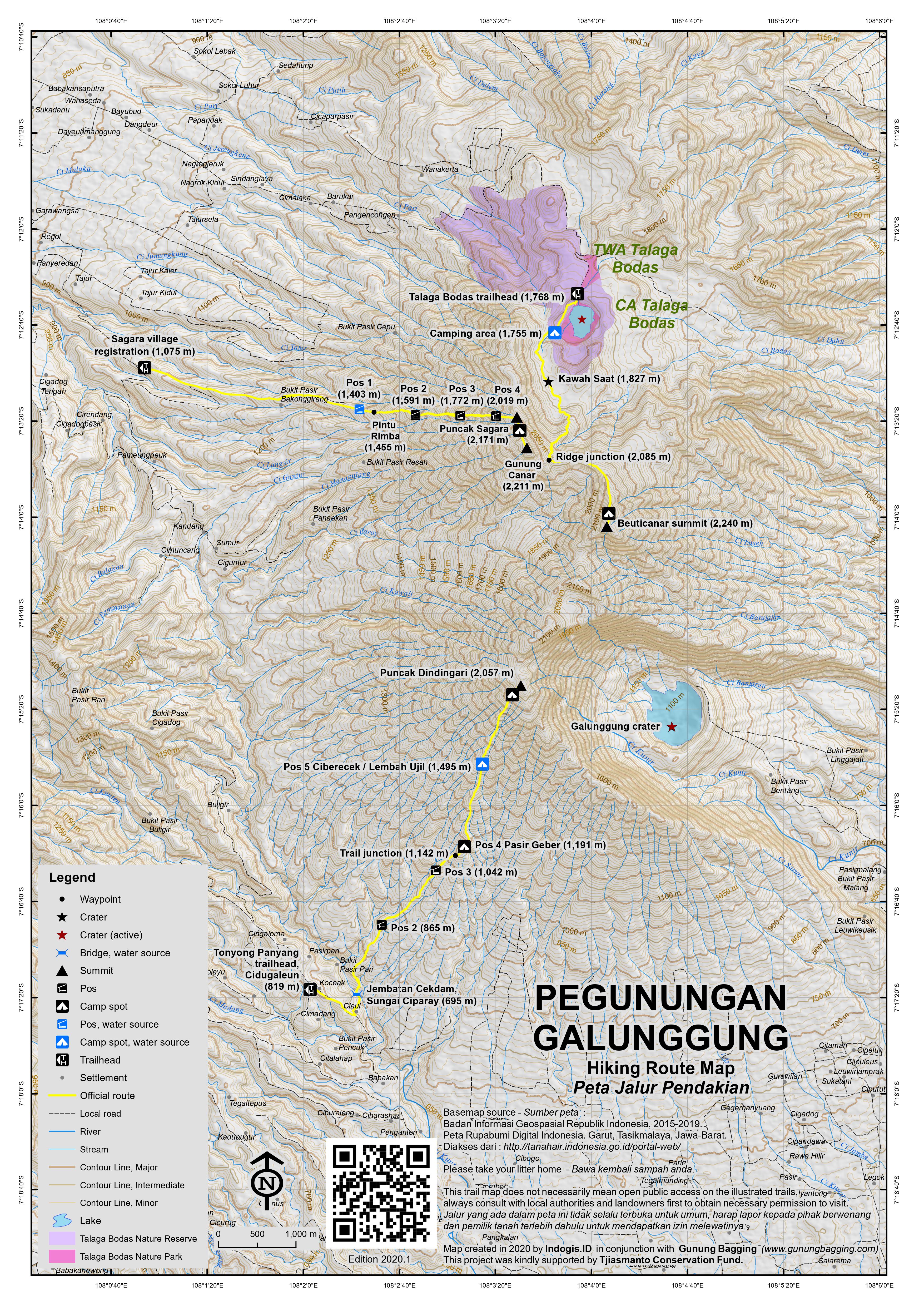
This Ribu is a huge and complex mountain massif consisting of Talaga Bodas lake and Kawah Saat dry crater in the north, Galunggung crater in the south and the highest peak, Gunung Beuticanar, lying inbetween, amongst a long ridge of forested peaks. An enormous eruption in 1822 caused many casualities and the last large eruption was in 1982 when a plane was forced to make an emergency landing after its engines filled with ash. Today, however, Galunggung crater seems relatively calm – certainly compared with nearby lively Papandayan.
Kawah Galunggung
Galunggung crater (a mere 1,200m above sea level) is close to the large town of Tasikmalaya and is popular and well signposted. There are two approaches – from Singaparna and from Indihiang (both are south of the volcano). From Singaparna, take the road heading north by a small police station. Once through the main entrance gate, the road divides into two – left is apparently steeper and takes you to leads to Area Parkir 510 – a place to lave your car or motobike before climbing up the 510 cement steps.
The slightly less-steep road going straight on from the main entrance gate takes you to a different parking area (Area Parkir 620) beneath what the new signs call the ‘yellow stairs’ (1,070m above sea level) – 620 cement steps up to the edge of the crater. For either staircase (both of which require a vertical ascent of around 130-150 metres) allow 45 minutes to reach the parking areas from Tasikmalaya by car or motorbike, and a minimum of an additional 15-20 minutes to climb the steps to the crater rim.
On the rim there are several warungs (not always open) and numerous monuments. More importantly, there are pleasant views down to the large crater lake below and near vertical cliffs walls beyond. The views back to Tasikmalaya are usually really good at sunrise (5:30am), so leaving your hotel no later than 4am is a good idea! Do watch out for scavenging monkeys on the rim. There are two routes down to the crater lake (on the far left of the rim path and down a third set of cement steps, or on the right down a muddy trail) but in 2017 both of these were officially closed due to landslide issues.
Unfortunately, the steep cliff walls beyond the crater mean that it is impossible to reach the highest point of the mountain from the southern/eastern approach. Indeed, at 2,240m the highest point is over 1,000 metres higher up than the crater. However, despite the unnatural feel of the rim due to the warungs and unnecessary monuments, a sunrise trip to Galunggung crater is very worthwhile for the views and very easy indeed for regular hikers.
Gunung Beuticanar (2,240m)
The highest point of the mountain range – known as Gunung Beuticanar – is a forested peak that very few people visit. Sometimes local student hiking clubs, such as Napak Rimba from Tasikmalaya, spend a few days hiking across the vast area, but for most ordinary hikers it remains something of an unexplored area. Access to the highest ridges is difficult, requiring either a long hike in from the Tasikmalaya side via the Ci Loseh river or the more recommended, shorter route from Talagabodas (sometimes spelt Telaga Bodas) lake. The Tasik route is rarely used, requires machetes and at least one night camping on the mountain.
The track up to the lake from the eastern side (i.e from Tasikmalaya via Ciawi or Cisayong) is (as far as we known at present) still not passable by motor vehicle and even motorbikes will struggle to make it up the narrow, bumpy, rocky path. The route from the western side (i.e Garut via Wanaraja) is much better because you can drive a motor vehicle up it all the way to the lake entrance.
From Wanaraja, there is actually a sign for Talagabodas (12km) as a ‘obyek wisata’ (tourist attraction) via a village (1,188m, named Panyingkiran on some maps). Beyond there village there are actually some very pleasant views across the valley to Guntur, Papandayan and Cikuray.
Eventually you will reach a track junction (1,583m) with the route from Tasikmalaya (apparently not passable in a vehicle). A sign for Talaga Bodas lies beyond (1,669m) and the hut/entrance to the crater lake (1,768m) is not far beyond. The lake is a delightful place to wander round – very similar to Gunung Patuha and Kawah Putih. There are sulphur gases rising from the rocks (particularly on the far side of the lake) and if you follow the track to the right there are two excellent hot water pools to bathe in. The peak itself is less than 500 metres higher than Talagabodas but it is more difficult than the average forest trail due to how infrequently it is used.
Actually finding the starting point of the overgrown trail to the top of Beuticanar can be difficult without local help – probably the most difficult thing about this hike is finding the correct path! There are various hunting trails but few continue up the ridge itself. If you haven’t already arranged local help you can ask for assistance at the warung at the entrance to the lake itself – indeed you may be able to arrange a guide to the top from the ‘forest conservation’ hut marked “Opalin”. It is climbed only a handful of times per year so the track is overgrown, often unclear but remarkably free of litter as a result.
In June 2010, Gunung Bagging conducted a small expedition to the summit with help from PPA Napak Rimba and their machetes. The trail from Talagabodas to the summit is now marked with small fluorescent yellow tape and blue string. To find the start of the trail, follow the track along the right (west) side of Talagabodas. Beofe you reach a small river/stream, look for a small white rocky area. Just before that, a narrow path leads gently up the densely vegetated hillside beside the small river – you should be able to hear the river near you on your left. In less than an hour you will come out of the forest and vegetation into a sandy, open area directly below the mountain ridge of Gunung Talagabodas and Gunung Canar (‘Gunung Tadar’ 2,211m, on the Bako map and the second-highest in the range). This is Kawah Saat (1,827m) a dry sandy crater southwest of Talagabodas with burnt tree stumps and sparse vegetation. It is a lovely area to have a break and enjoy the sunshine before entering the forest once again.
From the far edge of Kawah Saat, follow the trail on the left back into forest, across a little stream (the last place for water supplies) and then a small rockface where the path leads right, up towards the shoulder of the ridge between Gunung Canar and Gunung Beuticanar (‘Gunung Batujahar’, 2,240m on the Bako map) further to the south. The path here is often faint but try to follow the tags.
You reach a minor ‘summit’ at 1,980m before ascending to the saddle between Canar and Beuticanar. The most difficult part of the hike is a steep section where it is necessary to use tree roots as ropes to pull yourself up. Soon the ridge itself is reached (2,085m). It should have taken you approximately 3 hours to reach this point from the lake. From this point onwards, the route is very obvious as you simply follow the trail south (left) along the ridge towards Gunung Beuticanar (right would lead you towards Gunung Canar).
Views are generally quite limited although there are a couple of places along the ridge where you are allowed a glimpse of Kawah Saat and Talagabodas. The path along the ridge drops down slightly a couple of times before rising gradually to the grassy summit area of Gunung Beuticanar itself. It is a lovely area – there is very little litter due to how seldom it is visited and a real sense of pleasant isolation. There is enough room for about 7 tents on the flat, grassy summit itself.
A tree at the top is currently adorned with a ‘Gempala’ sign made by a student hiking group from Tasik on a recent visit. In clear weather, there are some nice views across to Gunung Canar to the north, east towards Tasikmalaya and several surrounding valleys. It becomes clear just how complex a mountain area this really is.
The Galunggung crater is not visible from here, but there are some white steps faintly visible in the distance on this northern side of the Galunggung crater area plus a peak further south (Gunung Galunggung – known as ‘Gunung Guntur’ on the Bako map) just above the steep Galunggung crater walls. After the 1982 eruption views were much less limited since lots of vegetation was destroyed but since then tall vegetation has grown back and the area remains fairly undisturbed by both humans and volcanic eruptions! A faint trail is visible leading down along the ridge to the southeast towards Tasikmalaya but this is a much more overgrown route than the short trip from Talagabodas.
It takes strong walkers only 3 hours to descend to Talagabodas and enjoy bathing in the hot water pools but the summit is a great place to camp for the night and enjoy the sunrise through the trees in the morning and most guides will recommend it. It is hoped that if enough people use the trail it will stay well-defined, free from excess vegetation and remain passable without the need for machetes. Once you’ve found the correct path it’s a thoroughly enjoyable and rewarding hike.
However, although Gunung Beuticanar is the highest peak of the range, and therefore the Ribu, the two most popular trekking routes on the mountain offer the finest views. Both of these routes, detailed below, were only opened in 2019 and are therefore still growing in popularity.
Puncak Dindingari (2,057m)
It was noted in January 2020 that there is now an official trekking route to the ridge overlooking Galunggung crater. They call this Puncak Dindingari, and there is indeed a Gunung Dindingari (1,688m) on the Bakosurtanal map on the south-west higher ridge which forms the crater wall. Further north along the ridge/rim are higher peaks including 1,804m and 2,114m before Gunung Guntur (2,188m) is reached.
This Gunung Guntur (not the more famous range nearer Garut) lies around 1.5 kilometres southwest of Beuticanar and is the highest peak above Galunggung crater wall, but connecting all these peaks is likely to be very difficult as it is rarely done so the vegetation is most probably dense. For the Dindingari ridge, there are actually 3 trekking routes and one is separate from the other 2 and still unofficial and barely used.
The main two basecamps are in the area of Cidugaleun (800m) to the southwest. Both lead via Pasir Geber, Ciberecek before reaching the fantastic viewpoint over Galunggung crater. This peak is known locally as Dindingari, but on the Bakosurtanal map it is unlabelled, simply a the part of the extensive rim just south of the un-named 2,114m peak. The most popular of the two trails starts lower down the village road, beyond an metal entrance gate.
The second route, Tonyong Panyang, is further up the main road and meets the other trail just before Pasir Geber. These two routes can be combined as the trailheads are not too far apart but you will still need ojeks to reach the your starting point if you have left your own bikes there. Each route requires about 5 hours up and local hikers say the best morning views are between the 5th and the 14th of each month.
The Tonyong Panyang route starts at an elevation of 819m, before Pasirpari, and certainly before the tourist attraction of Curug Ciparaya (Ciparay waterfall). The basecamp is a village house on the right side of the main village road with hiking stickers in the window. The trail drops down through the village plantations to Jembatan Cekdam (Cekdam Bridge, 695m) a pleasant bamboo bridge built in 2018 over the Ciparay river. There are several minor streams here, some presumably used for irrigation. This is the area where route-finding is difficult, so best be ready to ask locals for help or better still take a local guide with you.
Once over the bridge, the trail leads up again, through pine woodland and past a chilli field to Pos 2 (865m), which has two traditional huts nearby the trail. Pos 3 (1,042m) is next and comes shortly before an important trail junction (1,142m) which does not have any signs. This is where the other Dindingari trail meets the Tonyong Panyang trail, and it certainly seems that the other trail is the more popular, wider trail at present. Make a mental note and save a waypoint in your GPS if possible to make sure you don’t miss your turning on the descent!
Just beyond the trail junction is Pos 4 which is Pasir Geber (1,191m), a rough translate of which is ‘Breezy Hill’ and it has a wooden seat on which to sit and enough space for 3 tents or so. Listen and look out for lutung – there are many in the forests here. In this area you will also see the earth is largely comprised of coarse volcanic black sand, a sure sign of previous mega-eruptions!
Pos 5 is Ciberecek, also known as Lembah Ujil (1,495m). This is the largest camp area but obviously does not have great views being in the middle of the forest. It does, however, have a nearby stream down to the right of the trail and is the final water point. Do take care if filling water bottles here as the trail down to the water source is supposedly very steep.
Beyond Pos 5, the trail gets much steeper and much more slippery, with less black volcanic sand and more mud and roots. There is a clear view to the left of the trail (1,727m) at one point but then the vegetation once again closes in until almost at the very top.
Suddenly you find yourself on the edge of the precipitous Galunggung crater rim and Puncak Dindingari itself (2,057m). A few folk camp here, especially at weekends, but spots are very limited for obvious reasons! Just beyond the simple summit you can see the steep 2,114m peak to the north, which curves round to Gunung Guntur, forming the highest back wall of the crater down below.
The view to other mountains is equally excellent. To the southeast lie Gunung Karacak in the foreground, and the majestic pyramid of Gunung Cikuray behind.
After enjoying the panorama, return the same way or try the other nearby trailhead. The local Coffee Ciparay is worth a try too.
Note also that a third, shorter route leads up to the rim from Sukajadi (620m), Cigadog, Leuwisari, Singaparna to the south and it only takes an estimated 3 hours to the top. However, the peak reached is a considerably lower one than via Cidugaleun and the views correspondingly less impressive. Just to confuse things, this peak is labelled Gunung Dindingari (1,688m) on the Bakosurtanal map though anyone from Cidugaleun will say this is a different peak and the higher one is the real Dindingari. Perhaps it is easiest to call the ridge Dindingari, with a higher northern viewpoint and a lower southern viewpoint. There is no trail between the two summits at present and the steepness of the terrain probably makes it unfeasible anyway.
This shorter route can be arranged with Agrowisata PT TALI and when in the area you might want to visit the nearby Batu Mahpar which is a river (during the rainy season) over hardened lava from the volcano and also a site with various ancient remains such as graves allegedly from the pre-Islamic Galunggung Kingdom which existed from around one thousand years ago and was supposedly named after the volcano.
Puncak Sagara (2,171m)
Yet another great viewpoint on this mountain range is Puncak Sagara. Indeed, it is so great at sunrise that you could justifiably call it the finest viewpoint in the whole of West Java, as iconic a panorama as Central Java’s Gunung Prau on the Dieng Plateau. Assuming it continues to steadily grow in popularity, you are advised to avoid weekends if you like a bit of solitude!
Whereas Dindingari is best accessed from Tasikmalaya and has great views over Kawah Galunggung, Puncak Sagara is accessed via Garut and has great views over Talaga Bodas.
There are two basecamps very close to each other (one is in Tajur Kidul at around 1,250m above sea level and the other, seemingly the original, is in Kampung Sagara at 1,075m to the south of the Tajur Kidul starting point). Unlike Dindingari, it only takes around 3 hours to reach the top, and since 2020, the Kampung Sagara route is even easier, as motorbikes can be left up at Pos 1 (1,403m). No wonder it is so popular!
Puncak Sagara itself is not marked on the Bakosurtanal map as it was named after the village below. The peak is a point on the ridge above Telaga Bodas just to the north of Gunung Canar (‘Tadar’ on the Bako map, 2,211m), with the lower Gunung Piit (2,096m) approximately 1 kilometre to the north. It is a truly fabulous viewpoint.
The trail from Sagara village starts at the registration post (1,075m) but as mentioned above from mid-2020 it has become the norm for motorcyclists to continue with their bikes up the muddy plantation track to Pos 1 (1,403m) where there is a parking area and a piped water source. This saves at least 30 minutes from the previous estimate of 3 hours to reach the summit (not including breaks).
Pos 1 actually has some lovely views down to the city of Garut on the flat plains below and beyond to Gunung Guntur, and to the unfrequented and somewhat mysterious Gunung Karacak range just a few kilometres to the south-west.
Just a few minutes beyond Pos 1 is a cluster of bamboo warungs which were popular before the coronavirus closures and in July 2020 are yet to re-open. This is at the ‘pintu rimba’ or entrance to the forest (1,455m) and you soon find yourself in very pleasant forest.
One of the great things about the local trail management is that the Pos actually all have a bamboo seat or two where you can have a short rest without sitting on mud. Therefore these Pos are truly deserving of the name ‘Pos’! They are not typical places to camp at though because the trek is short and the summit itself is by far the greatest place for views. Pos 2 is at 1,591m and Pos 3 soon follows at 1,772m. The final Pos before the summit is Pos 4 (2,019m).
Rather like Puncak Dindingari, you suddenly emerge from the forest on the edge of a very steep rim. Here at around 2,171m according to GPS is the Puncak Sagara summit sign and a very pleasant wooden fence to prevent hikers from falling over the edge! Down below is the turquoise blue lake of Talaga Bodas and the dry crater of Kawah Saat. In the distance beyond Talaga Bodas, in clear weather, is the huge Gunung Ciremai. In particularly clear conditions you may be able to even spot Gunung Slamet in the distance to the east, probably peeking out over a sea of clouds, with the much lower and closer Gunung Sawal in front.
Looking in the opposite direction, back down towards Garut and to the north-west is almost as impressive, with all of the major mountains south of Bandung visible. Directly to the north, following the crest of the ridge, is Gunung Tampomas near Sumedang.
And if you follow the ridge a little way to the south, you can glimpse Gunung Beuticanar, at 2,240m the true highest peak in the range. As Puncak Sagara is unquestionably the finest viewpoint here, very few hikers bother to head south towards what is Gunung Canar (2,211m) – the second highest peak in the entire Galunggung range. It is overgrown but a faint trail exists, and in places you can look west and see Cikuray and Papandayan between the trees.
For hardcore hikes, a traverse to Beuticanar is probably possible, as the terrain does not look too steep, but it all depends if anyone has been that way in recent weeks because if they haven’t it will surely be very overgrown and require an extra day or so. It is definitely a possible traverse to consider, with the option of finishing down at Talaga Bodas, but you would need experienced local assistance.
You may have noticed that the Tajur Kidul trail does not meet the Kampung Sagara trail until the very summit. Indeed, it is a totally different trail, reaching the rim a little way to the north of Puncak Sagara. An ascent on one trail and descent via another is technically possible, but it would depend on getting permission from the basecamps and you would also need to return to your original starting point to either sign out or collect your motorbike.
If returning down to Kampung Sagara, fast hikers can be back down at Pos 1 in just 90 minutes! Make sure you stop and try the local Puncak Sagara coffee opposite the registration point.
Gunung Sadakeling (1,676m)
A considerable distance north of Sagara and Galunggung, east of Cibatu, is Gunung Sadakeling, the most northerly cluster of peaks in the vast Galungung range. Indeed, Sadakeling is a mini-range all of its own, but rarely visited by hikers except those wanting to visit various Islamic graves on the lower slopes.
This area – Malangbong – is well known for having been a place in the fairly recent past where political Islam grew, with a group setting up an education centre in the area during the mid-twentieth century and declaring Indonesia to be an Islamic state. Interestingly, the mountaineous area here was also used as a place of training in 2003 by Aceh freedom fighters.
The best access point for the summit of Sadakeling is north of the range, not far from Warung Bandrek. A road leads all the way up to the village of Dukuh, Desa Karyamukti (1,109m) where bikes can be left near the warung. Please register your hike with the village head before starting.
From the village, a muddy track on the right leads up through coffee plantations before entering pleasant pine woodland (1,193m) still interspersed with coffee. A sturdy wooden pondok (1,353m) on a ridge is reached in just 30 minutes or so. There are great views from here over to Gunung Haruman and Kaledong to the west. There is also often a source of mountain water from a pipe.
Continuing up the ridge you will see another, smaller shelter (1,381m) in a mini valley. Before this, take a steep and narrow path up to the top of the ridge on the left. At the top is an old wooden shelter next to a grave (1,394m). This is apparently the grave of Raden Ayu Ratnaningrum, a story about whom gives the mountain its name (see below). Occasionally local hikers visit this point, but very few continue any higher up.
To reach the true summit of Sadakeling, continue up the ridge, passing a couple of wooden huts in the last section of cultivated land before the proper forest begins (1,487m). A very important and unmarked junction is at 1,564m where you must take a right turn into forest on a much narrower forest trail, leaving behind the wider forest trail as it descends beyond the junction.
Sadakeling actually has two main peaks, and the eastern one (approximately 1,645m) is more regularly visited, presumably by local hunters. To reach the true summit, which is the western one, you need to find a way down into an overgrown col (1,609m) between the two summits before making your way up onto the summit ridge via a large rock (1,640m). There do not appear to be many leeches here but there are plenty of spiny vines meaning gloves here are useful.
The summit ridge is grassy and in clear weather will undoubtedly offer splendid views. The Bakosurtanal map suggests 1,675m, and an older colonial-era map suggests 1,676m. Our GPS device gave readings of over 1,680m so we will stick with the 1,676m for now. In early 2021, there are no summit signs or monuments at all, but perhaps this will become a popular destination in time. It should have taken you around 2 and a half hours to reach this point and it is less than 2 hours back down to the village by the same route.
In actual fact, Sadakeling peak is not the highest in this little range. The true highest peak in the Sadakeling area is labelled on the Bakosurtanal map as Gunung Cipakumanggung (1,720m). There are no reports of any hikers having been there recently, so access points are unclear, although from the north-east side near Cipeundeuy might be worth a try. It can be seen from the area just before the forest entrance (1,487m) on the left, with a middle peak (Gunung Sagobok, 1,660m) lying inbetween. The forest on both peaks appears to be in good condition.
Interestingly, a lesser peak to the south-east as a very unusual name indeed. Called Gunung Eweranda (1,569m), this means ‘the mountain of copulating with widows’. Sadakeling itself also has an interesting story behind the name. Initially thought to mean ‘the sound of darkness’, local sources suggest that as thought, “sada” means sound, but “keling” means a type of bird, with another version says “keling” means the ring worn by local woman Raden Ayu Ratnaningrum and which locals say could be heard in the mountains after her death.
From Pepep of Gunung Institut, Bandung: “Raden Ayu Ratnaningrum is said to have been accused by her partner Raden Wiradikusuma of committing “treason” because she had a relationship with another figure (a kind of bird) named Ciungwanara. In an effort to defend himself, Raden Ayu Ratnaningrum chose to end her life by committing suicide. To prove who was right, before dying she told that if the blood that came out of her body was red, it showed her guilty, but if the blood that came out of her body was white, it showed that she was innocent, and his accusation of treason was false. It is said that the blood that came out of her body was white, and that showed her innocence, but the price for truth had to be paid with her life, and in the end her body was buried on one of the mountains which after the incident was named “sadakeling”.
Bagging information by Daniel Quinn (Galunggung crater information updated in November 2017, Dindingari and Sagara trek info added in July 2020, and Sadakeling info added in February 2021). The July 2020 expedition was kindly supported by Tjiasmanto Conservation Fund.
Trail Map
For a high quality PDF version of this and other trail maps, please download from our Trail Maps page.
Local Accommodation
Practicalities
- Getting there: For Galunggung crater near Tasikmalaya, either take one of the many direct buses from Kampung Rambutan and Lebak Bulus (Budiman Rp85,000, Primajasa Rp60,000 in 2017), or take a train to Tasik from Bandung or stations further east such as Yogyakarta, or fly with Wings from Jakarta Halim. For Talagabodas and Beuticanar peak, from Jakarta, take the toll road to Bandung and continue beyond to the end of the toll at Cileunyi. Follow signs to Garut and when in the city take a left turn to Wanaraja. From Wanaraja, take a right up an increasingly bumpy road at a sign for Talaga Bodas. The road is not suitable for ordinary cars – a farm vehicle or ojek from Wanaraja would be a better idea. Otherwise it’s a 12km walk-in. Primajasa buses to Garut leave from Jakarta’s Lebak Bulus and Cililitan bus depot frequently during the day.
- Guides and GPS Tracks: Want a PDF version for your phone? Looking for a guide? Need GPS tracks and waypoints? Gunung Galunggung information pack can be downloaded here.
- Trip planning assistance: Would you like Gunung Bagging to personally help you in arranging your whole trip? Please contact us here.
- Permits: No special permits required but, as usual, take a photocopy of your passport photo page just incase. At Galunggung crater, the entrance fee is Rp5,000 (at the bottom of the steps to the rim – in 2017). You may be asked for extra down at the main entrance but if you go for sunrise it is likely that nobody will be at the booth. For Talagabodas and Beuticanar, Indonesians get in for about Rp7,500 but according to recent reports all foreigners (even those with KITAS/KITAP etc.) are asked to pay Rp100-150,000 per person at the entrance to the lake. For Puncak Sagara and Puncak Dindingari expect to pay around Rp10,000 per person plus a smiliar amount for parking a motorbike.
- Water sources: There are warungs at Galunggung rim but not always open. For Beuticanar, the last place for water is a small stream at 1,827m just beyond Kawah Saat – the water at Talaga Bodas is obviously not safe to drink due to the high sulphur content. On the Puncak Sagara trail from Kampung Sagara, a water pipe is usually available at Pos 1. On the Puncak Dindingari route from Tonyong Panyang, you can fill up near the start at Jembatan Cekdam or up at Pos 5.
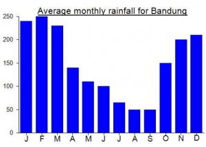
Local Average Monthly Rainfall (mm):
Location
Origins and Meaning
The origin of the word ‘Galunggung’ is unknown. ‘Beuticanar’ comes from two local Sundanese words ‘beuti’ meaning ‘tuber’ and ‘canar’ meaning ‘thorn’. As the name implies, the forest is teeming with thorny vines. (Tifa Asrianti, Jakarta Post, 2010)
Links and References
Wikipedia English
Wikipedia Indonesia
Tifa Asrianti, The Jakarta Post, 2010. Beuticanar – The Road Less Traveled.
Accessed from http://www.thejakartapost.com/news/2010/07/18/the-road-less-traveled-beuticanar.html
i’m already conquer Papandayan Mount
https://www.youtube.com/watch?v=iEpIcHAu_Q4
if you guys interested to watch Galunggung
then i will make a plan to it
Well, the weather might have been pretty dreadful across Java this last week, but we still managed a decent hike up Sadakeling, which in Java is an obscure mountain because of the many higher peaks close-by which get all the visitors, yet would be a popular hiking destination in many other places with less local competition, and indeed it may become one in the future anyway, as seemingly every minor hill-top across the island becomes an Instagram selfie spot!
There was not a lot of info to go on online, with a few photos of ‘hikers’ at the grave site but no info on a trail and no pictures of a summit. Pepep from Gunung Institut did some research and decided from the north would be the best, as indeed it was. For Sadakeling peak the route as described above makes the most sense.
But Cipakumanggung remains a mystery. Perhaps we’ll try it from the Cipeundeuy side later in the year….
I went out to Garut with a group of co-workers over the long weekend a couple of weeks ago (Thanks Dan for the tip on Puncak Sagara!) and had an absolutely fantastic time. Had a local guide organize transport from Jakarta, a couple visits to some local waterfalls. (Curug Jagapati might well be the most impressive waterfall in all of West Java and was absolutely amazing!) Then we finished the trip off with a hike up Puncak Sagara and camping at the top so we could enjoy the sunrise. It was absolutely stunning and the stars at the top of the mountain were glorious before we went to bed. Our local mountain guide said he thought we were the second Bules to be there, I assume you were the first Dan! It was a nice tough climb while carrying a two year old but an absolutely fantastic peak and some really nice jungle towards the top. A nice bonus was in the morning we found a bunch of pitcher plants growing around the area that we had set up our tents and the views at sunrise were amazing!
It is quite incredible that after thinking I had done all the major peaks in West Java, and seen all the iconic mountain views, that 2 new hiking destinations suddenly emerge towards the end of 2019, and both on the same mountain range – Galunggung.
Dindingari is a great spot overlooking the Galunggung crater, and Sagara is perhaps West Java’s finest viewpoint bar none, overlooking Talaga Bodas. Neither are major peaks in and of themselves, and are both fairly unimportant points on the map, with higher peaks close by. But, in terms of views, they really are the finest – better than Beuticanar.
I had put these two together as a great weekend trip, top of the list for when they were open again. Well, they both opened towards the end of June, with West Java seemingly ok to explore again if following the already understood health protocols.
As for getting there from Jakarta and the surrounding area, however, the whole thing is one massive contradictory mess, with almost no train services having resumed yet, and passengers needing health certificates, but the usual bus operators running frequently.
I got to Tasikmalaya and my excellent Dindingari guide met me at the station. After some local coffee and snacks we set off at just before midnight, dropping down into the river valley at the back of the village, where evocative and repetitive bamboo music plays all night to scare rats away from the crops (is it a tape or an automatic water-powered sound keeping it running?), crossing the bridge over the Ciparay river, and then up again on the other side. The other route is more popular and it probably doesn’t involve such a drop at the start (and end, if you descend the same way) but I really enjoyed the trek regardless!
The forest here does not boast many older trees, presumably because the 1982 eruption wiped so many of them out. But in terms of wildlife, it is full of birds and lutung too. There are one or two leeches but nothing to worry about or bother to wear leech socks for.
At the top there were about 15 or so local hikers from the Tasik area, quite surprised to see a foreigner emerge from the mist at 5am. Indeed, the cloud was quite thick, but the full moon made for some decent photos, firstly down into the deep crater below, and also to Cikuray swathed in a white blanket in the distance. In better conditions it is likely to be a great spot for photos.
After getting back down, I headed round to Garut, to get some sleep before starting on a second night’s hike, this time up Puncak Sagara. A shorter hike than Dindingari, but the weather forecast was not looking too wonderful.
We set off from Kampung Sagara at around 2am – the perfect time if you are not bothering camping up there (most do bother to camp!) Now that bikes are taken up to Pos 1, you only have 750m or so of ascent in total, so easily done in 2 and a half hours including short breaks.
The winds were quite strong, with branches being scattered across the trail and I was not optimistic about getting the view. But how wrong I was – it was an absolutely glorious and atmospheric dawn, with clouds draped over Gunung Sawal, and at one time covering the western side of the ridge but not the eastern. Absolutely superb.
There were a friendly bunch of campers up there, chatting away. It is not surprising that this is already popular, because as soon as any hiker sees this view they want to visit for themselves. If I had to choose one trail to recommend on the Galunggung range it would be this one – short, well-organized, friendly, and stunning views. It’s a shame it isn’t the highest peak in the range but as I say above, perhaps it could be combined with Beuticanar in the future, with a traverse from Sagara to Beuticanar before dropping down to Talaga Bodas….
The trail from talaga Bodas has been used “a few times”, so it’s “findable” with a compass\GPS.
You may want to check this video to prepare yourself (that is what we did) : https://www.youtube.com/watch?v=NsxRQRVMcdg
A new way has been opened. you can climb Beuticanar starting from Curug Blek (black) = West part of the range
Many thanks for your recent reports. This is my next gunung actually – shame we just missed crossing paths by a few days!
Just about saw Telagabodas and Beuticanar from the new Wings Air flight to Tasikmalaya yesterday. It’s a shame that the flight is late morning meaning the view is usually really bleached out and hazy – it would be a fantastic view first thing in a morning I’m sure.
I have something to ask, is there a track from the beuticanar-talagabodas ridge to the talagabodas’ peak Dan?
Is it possible to reach talagabodas peak and beuticanar peak at 1 trip. Thank’s…..
Hello. I haven’t been there for many years but hopefully there is still a trail. Be interested to hear an update….
Just back from a trip to Tasikmalaya and Galunggung crater. I had originally planned to fly direct from Halim to Tasik with Wings (new route) but a hangover and a dreadful forecast of torrential downpours and thunderstorms made me choose the bus ride rather than a turboprop that would probably be delayed anyway. Budiman executive superior from Kampung Rambutan was excellent – not messing around or picking people up every couple of miles on the hard shoulder of the toll road, and we also had good traffic despite the serious rainfall. Rp85,000 well spent.
Stayed at the Crown Hotel as the last couple of times and sorted out an ojek chap to pick me up at 4am the following morning (this morning). We were at the ‘area parkir 620’ by 4.45am and nobody was in the ticket booths either there or down at the main entrance. I was up at the rim by 5am… 2 other local hikers and no warungs open. Enjoyably serene.
The rim is now littered with not just normal litter but also with ill-advised monuments of various types. Worst of the lot is a large ‘selfie sign’, just beyond a wooden ‘selfie deck’. The whole point of natural landscapes is that they are (ideally) not cluttered with signs of humankind and beautiful enough as they are. Well, the guardians of the environment / authorities clearly think that to attract tourists they need to build these monstrosities that would, were they erected by anyone non-official, be normally regarded as vandalism. Some tourists might be so self-obsessed that they only hike in order to take a picture of themselves next to huge signs as opposed to the awe-inspiring surroundings but their intelligence is likely to be limited. There are already two horrible selfie spots at Bromo that have provoked an outcry, a new building going up at Kawah Ijen rim, metal railings around Ciremai crater rim, and probably lots of other ‘wild’ places being urbanized too. Leave these monuments in urban areas! What a shame.
The view itself was lovely between 5 and 6am… from the lights of Tasikmalaya below to swirling mists around paddy fields. Stunning and different every single minute.
Came back to Jakarta on a Primajasa bus which was cheaper but took a lot longer as it was basically a large, glorified angkot collecting passengers every couple of miles. On the plus side, the tahu sumedang at Cileunyi was as delicious as ever!
Hi Dan, hope you are fine. On the back of a Java Lava walk on Papandayan, 5 of us went to Telagabodas last weekend. A few bits of information:
(1) the road is paved all way the up to the lake and is in good enough condition for any normal “sedan” to take it – a few potholes, but nothing worse than a regular Jakarta street (without the speed bumps!);
(2) there is a large parking lot surrounded by food stalls about 500m below the lake, and a huge poster advertising entry prices. Sadly, while it is Rp. 7,500 pp for Indonesians, it is a whopping Rp. 150,500 for foreigners (including KITAS holders!). Not worth the cost by a big margin … but the views on the way up in the early morning were very pleasant.
Best regards
Christian
Thanks for this information Christian. The pricing situation is getting completely out of hand. I am amazed that KITAS holders have to pay the vastly inflated price. Some great views up there, especially early in the morning as you say.
wait….
WUT ? it’s interesting to know about this topic .
i’m from tasikmalaya and of course i know about talaga bodas, beuti canar ( i’ve heard ) .
when i read about this comment, me shock :O because i read the word about “napak rimba” on this comment.
obviously,i know about napak rimba ( because, it’s extracurricular from my school ) heheh :).
well, tomorrow sunday, napak rimba and me (partisipants ) gonna reach talaga bodas ( for the 2nd time ? ahaha 😀 )
bytheway,thx for the information mr.dan .
http://www.facebook.com/napakrimba
I’m glad you’ve been there, Dan. Congratulation 😀
Many thanks to Adam and the Napak Rimba team for a successful expedition from Telaga Bodas to the summit of Gunung Beuticanar via Kawah Saat. A great weekend.
there comes your army at your email, Dan :p
I have now failed twice to reach Beuticanar, the highest point of the mountain area. Earlier in the year I had a look from Galunggung crater but there are no trails and it is unrelentingly steep and densely forested. Talaga Bodas in the north seemed liked a much better starting point but on Saturday we were unable to find a trail through the forest and thick foliage onto the high ridge between Talaga Bodas and Galunggung. Perhaps there is a third way………there does appear to be another track leading to the east of the lake on Google Earth – on the track up from Tasik a few hundred metres before the junction with the Garut track. Otherwise, perhaps it’s time to call in an army of machete-wielding locals!
Some interesting news stories this week about the 1982 Galunggung eruption and how the ash plume brought down a British Airways flight…
http://www.telegraph.co.uk/travel/travelnews/7593234/Airline-captain-recalls-flying-through-volcanic-ash.html
http://news.bbc.co.uk/2/hi/uk_news/magazine/8622099.stm
http://news.bbc.co.uk/2/hi/uk_news/8623210.stm
I climbed Galunggung shortly after the 1982 eruption. The approach was through a village in which some houses were almost completely covered with ash.
Actually, it’s an easy walk except for the last bit. We went down into the crater which was still active – probably not too sensible!