
Facts
- Elevation: 3,078 m (10,098 ft)
- Prominence: 2,792 m
- Ribu category:
 Sangat Tinggi
 - Province:
 Jawa Barat (West Java)
 - Coordinates: -6.8929, 108.4069
- Rating:

 (23 votes) Add your rating
 Loading...
 - Other names: Ciremay, Ceremai, Cereme, Careme
- Eruptions: 1698, 1772, 1775, 1805, 1937-38, 1951
- World Ribus ID: 69015
Photos


Bagging It!
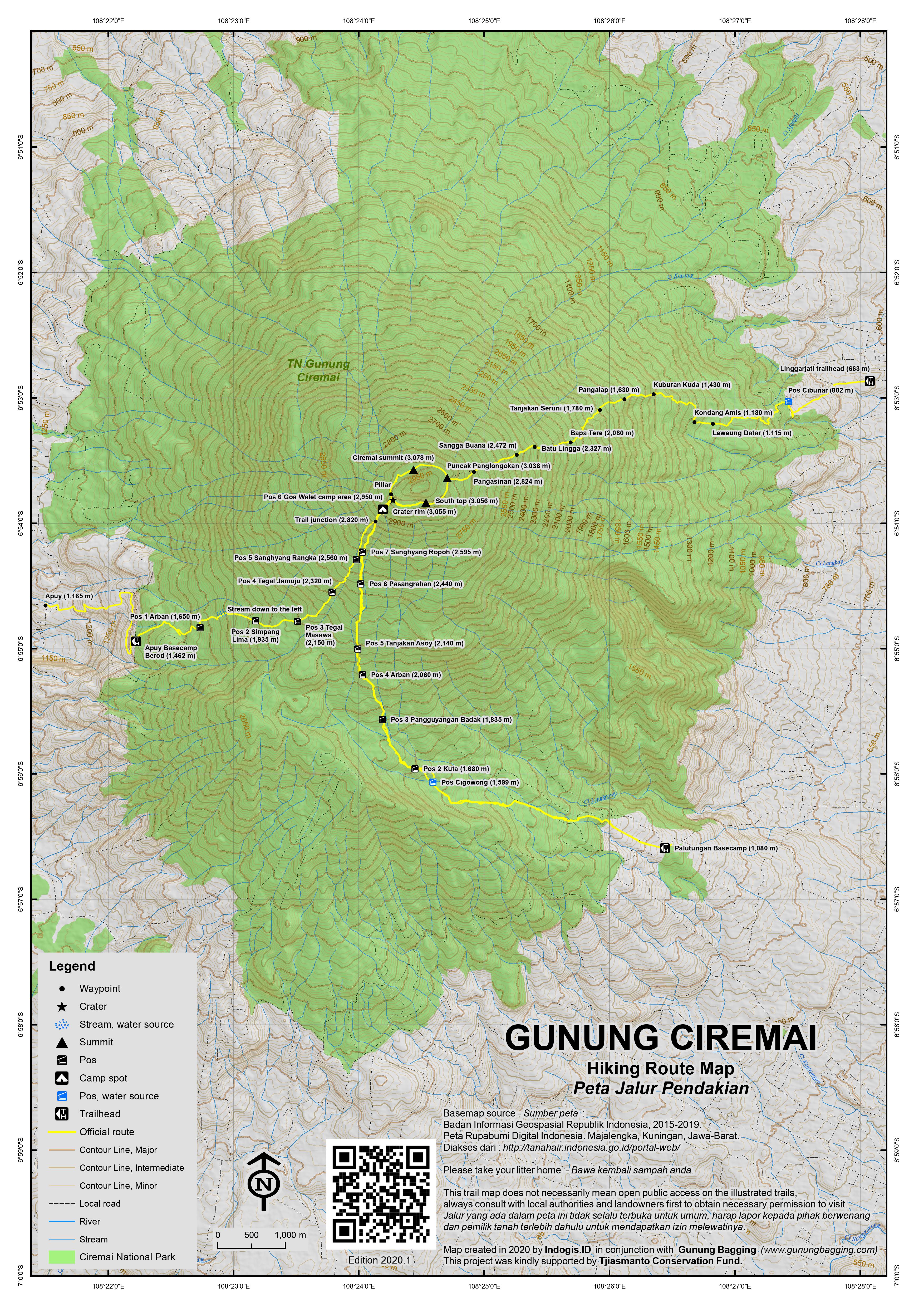
A solitary giant, this Ribu is the highest peak in West Java province and one of the most popular hikes in Indonesia. The starting points for the hike are 2 to 3 hours by car or public bus to the south of Cirebon, which itself is easily accessible from Jakarta by train. There are three starting points and it is easy to ascend by one route and descend the other. The Apuy route is the easiest as it starts at a higher elevation. The crater is both deep and impressive, and a full circuit of the rim can be done in about one and a half hours.
Apuy route
Take a bus or car to Maja, and from there continue by car or motorbike via Argapura to the beautiful village of Apuy. A neighbouring village is called Cibuluh – which may be better known. The road climbs steeply and is a little rough as you get to the lower part of Apuy village (1,165m), and it may be necessary to hire a local motorbike taxi (ojek) to for the last 3 to 4 kilometres because car access might be impossible. There are official National Park porters and guides available in Apuy, if you ask.
The trail from Apuy is in good condition and is steep, but shorter and easier than from Linggarjati which starts only a few hundred metres above sea level. The ascent should take 5 to 7 hours. After following a cement track which snakes up the hillside between fields of onions and potatoes you will reach the entrance to Ciremai National Park which is a cement shelter and warungs (Berod – 1,462m) next to a small pond.
There are five posts and it takes approximately one hour between each of them: Pos I Arban (1,650m) a stone shelter beyond crop fields and just prior to entering the forest, Pos II Simpang Lima (1,935m), Pos III Tegal Masawa (2,150m), Pos IV Tegal Jamuju (2,320m) and Pos V (Sanghyang Rangkah, 2,560m). At 2,820m the Apuy route joins with the Palutungan route. Pos VI (2,950m) is a the best spot to camp, being just above a small extinct side crater called Goa Walet (Swallows’ Cave) and just 20 minutes from the crater rim. You may find a small amount of water inside the Swallows’ Cave. There are one or two places to camp on – or just below – the rim itself but it is pretty exposed. The rim itself is reached at an elevation of around 3,055m.
Linggarjati (Cibunar) route
Closer and easily accessible from Cirebon by the bus to Kuningan but over 2,200 metres of elevation gain required. A long, tough climb (or descent). Get off the bus at Linggarjati (663m) and then take a motorbike taxi (ojek) or mini-bus to the starting point at Pos Cibunar (802).
This ascent is very popular, but can be very dusty before entering the forest and the trail is heavily eroded in many places. The ascent should take 7 or 8 hours; there are porters and guides available in Linggarjati. Given the accessibility of Linggarjati it is a good option to descend this route after ascending from Apuy, though it’s a long way down.
The trail leads via Leuweung Datar (1,115m), Kondang Amis (1,180m), Kuburan Kuda (1,430m), Pangalap (1,630m), Tanjakan Seruni (1,780m), Bapa Tere (2,080m), Batu Lingga (2,327m), Sangga Buana (2,472m), Pangasinan (2,824m) before reaching the rim on the eastern side near Puncak Panglongokan (3,038m).
Palutungan route
From Cirebon, take a mini-bus to Cisanatana, and then an ojek (motorbike taxi) to Palutungan (1,080m). The trail leads via Pos Cigowong (1,599m), Pos 2 Kuta (1,680m), Pos 3 Pangguyangan Badak (1,835m), Pos 4 Arban (2,060m), Pos 5 Tanjakan Asoy (2,140m), Pos 6 Pasangrahan (2,440m) and Pos 7 Sanghyang Ropoh (2,595m).
This route then meets the Apuy route at around 2,820m.
Bagging the summit and/or doing a circuit of the rim
Assuming you reach the crater rim from the Apuy or Palutungan route there is a cement pillar on the rim just a hundred metres to the left (north) and if you follow the rim clockwise you will reach the highest point of Ciremai (and West Java) in just over 20 minutes. Some sections of the rim are too bushy or too narrow (or both) for hikers to be able to follow the absolute top so you have to drop down on the small, overgrown trail from time to time.
The highest part of the rim is marked with a cluster of red bricks and further along with the remains of some kind of sensor equipment. A full circuit of the rim can be made in about one hour and a half, but not many people do this and it is better to do it the other way around (reaching the summit close to the end of the circuit). Several sections of the trail do not offer much in the way of panoramas but for – the most part – the views to Slamet, the north Java coast and the many hills of West Java are spectacular.
If doing a full circuit, we would recommend doing it anti-clockwise, as the first half of the trail is frequently used because you must pass this way to get from the Apuy or Palutungan routes to the Linggarjati route. Key points (in anti-clockwise order) are as follows.
Puncak Sunan Mataram which is the ‘southern top’ (3,056m) and is a flattish, exposed area with space for 5 or 6 tents on the rim itself and with great views down to Waduk Darma (Darma Reservoir), another ten minutes and you’ll be at a mini-top with great views over the crater. After this, the trail gets bushier and passes under the highest parts of the rim and past a couple of spots suitable for a tent or two and with great views of Gunung Slamet in the distance.
Another ten minutes and you will be at Puncak Panglongokan (3,038, according to the sign) which is close to the area where you descend on the Linggarjati route and features a cement pillar. Further along the rim the trail gets rougher and you will need to clamber over a few dead branches and under low bushes. The views here of Ciremai crater are particularly good. After a minor drop to a superb viewpoint over the edge of the rim there is a very narrow section which you must be very careful on.
Following this, the overgrown trail leads fairly gently up onto the highest section of rim. This section has two or three spots of equal height, the first being where the broken equipment lies and the final being where the red bricks are. The latter is a far, far better viewpoint, particularly of the other peaks of West Java notably the pyramid-shaped Cikuray, steaming Papandayan and the great mass of tops north of the Bandung plain. Another couple of minor ups and downs and you will be at the cement pillar just north of where the Apuy and Palutungan routes reach the rim.
Bagging information provided by Andy Dean (2009), updated thanks to John Hargreaves (September 2011), and Dan Quinn (April 2013).
Trail Map
For a high quality PDF version of this and other trail maps, please download from our Trail Maps page.
Practicalities
- Getting there: For domestic flights from or to West Java, such as the airport in Bandung, we recommend Baolau. To get to Cirebon from Jakarta, the best option is an executive class train from Gambir station. The journey takes 3 hours. To reach Majalengka (the nearest town to Apuy) from Jakarta by car takes about 5 or 6 hours.
- Guides and GPS Tracks: Want a PDF version for your phone? Looking for a guide? Need GPS tracks and waypoints? Gunung Ciremai information pack can be downloaded here.
- Trip planning assistance: Would you like Gunung Bagging to personally help you in arranging your whole trip? Please contact us here.
- Permits: You are required to register at the starting points. At Apuy it costs Rp 8,500 per person (September 2011). The mountain is often closed during Ramadan.
- Water sources: None high up on any of the routes except sometimes a small amount in Swallows’ Cave. Take plenty with you and fill up at the trailheads.
- Accommodation: Try the Booking.com map above or use this link to search for suitable hotels, homestays, resorts and apartments for your trip.
- We recommend Safety Wing as travel insurance for overseas travellers and tourists hiking up to elevations not exceeding 4500 metres.
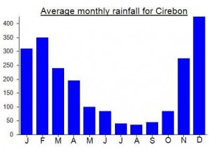
Local Average Monthly Rainfall (mm):
Location
Click on the blue arrow ![]() (top right) to see your current location on the map
(top right) to see your current location on the map
Origins and Meaning
The name Cereme or Ciremai is derived from the Sundanese word for Otaheite gooseberry or Malay gooseberry. (Wikipedia, 2011)
Links and References
Wikipedia English
Wikipedia Indonesia
Wikipedia. 2011. Mount Cereme. Accessed from http://en.wikipedia.org/wiki/Mount_Cereme
Landed at Kertajati airport early morning and was picked up by guide. Started hike from Apuy at 910am. South summit at 1240pm. Real summit at 1335pm. Came down the same way and finished at 1625pm. Transfer to Slamet basecamp for Mt Slamet the next day.
I summited Gunung Ciremai on 27/6/24 via Apuy solo without a guide. From Bandung I hitchhiked a fair amount, then from Tomo, Sumedang, I took an angkot a little past Majalenka (maybe 30,000rps?). I told the driver I’m going to Apuy and he told me where to get off. I’m not endorsing hitchhiking, please do so at your own risk, but in Indonesia as a solo female traveller I’ve been able to get around easily and more comfortably by hitchhiking. From there I took an ojek to a homestay in Apuy, as close as I could find to base camp (50,000 rps for ojek). I was surprised to find that most of the homestays I searched on Google maps weren’t open at the time I visited, and after a while talking to locals I was taken to “Rumah singgah & Transport Pendakian Ciremai Via Apuy Kang Gigin” (name on google maps). You can probably just sleep at base camp as well for free if you ask, something I’m just now realizing. From there they took me to a nice homestay for 100k, where I could pay for breakfast and dinner since there are basically no restaurants in Apuy. From my homestay I was able to hitch a ride with some farmers going to work and they took me all the way to base camp, but I was told the ojek is 50,000 one way. I paid the 225,000 rps registration fee that included a breakfast at that time or the next morning when I came back at one of the many base camp warungs. Also on my way there I noticed another accommodation “Villa Saung Apuy” that is slightly closer to base camp and looked quite nice for trekkers. Ciremai was certainly one of the more difficult gunungs I bagged. There’s a good amount of elevation gain and you’re looking at around 17 km round trip (I walked back to my homestay from base camp, extra 3km). I started around 8am after base camp opened for registration and realized soon that I’d be arriving at base camp extremely early. I took a nap at each pos on the way, and still arrived at camp (pos 5) around 1 pm. The locals porters were shocked I was camping alone and insisted that I stay next to a local porter who was very hospitable, and even insisted on packing up my tent the next day. Typical Indonesian men, not used to seeing women do crazy things alone. At the summit I traversed around the entire crater. Totally recommend, but make sure you’re prepared to go on a completely overgrown trail that actually disappears completely at times. I just noticed that the last comment here states that a guide says this is no longer possible– oops. I found a quiet place to watch the sunrise on my own and was completely alone. Do it counter clockwise. The first half of the traverse is very well marked and the trail is well-trodden, lots of trash signaling that people have in fact been there before. However at a certain point, the trail practically disappears and you’re almost trailblazing for a few hundred meters. You have to practically crawl under branches and trees covering the path, but it’s possible and mostly safe 😉 use your best judgement and discretion. Overall one of my favorites so far, amazing sunrise with a nice view of Slamet, a very tiny Sumbing and Sindoro, and one other stratovolcano off to the west? (I’m not sure exactly, maybe Gunung Cikuray? Looked quite tall) in the distance. Maybe possible to avoid paying the entrance fee by going in the middle of the night for sunrise if you don’t want to camp. Would be a long day but doable for sure.
I did the Apuy route with a JavaLava group last week. We were told no camping above 2400m, or pos lima. It’s still a good solid hike from there to the rim. Our guide said there has been a few longsor, so it’s “impossible”.to do a full circuit of the rim.
By the way, Dan, I’d like to express my appreciation for this website. What Man in Seat 61 is to railway travel, you are to the hills and mountains of Indonesia. Good job!
Ciremai is closed until early next month (i.e for all of Ramadan). A strange time of year to close a mountain – the more typical January and February would be a much better choice, especially for those of us who enjoy a period when less hikers are around.
https://www.thejakartapost.com/travel/2019/05/11/mount-ciremai-closed-for-hikers-until-early-june.html
I tried to climb from Apuy today but was informed mount Ciremei is closed till next year due to forest fires started by trekkers cooking
Did a 1-day summit via Apuy on 28-Feb-2019. Description by moderator is great, as always, so I’ll just leave a few thoughts:
1. Getting to the mountain: Getting to Ciremai was quite enjoyable. I took the first train from JAK to Cirebon. My motobike rental was waiting for me at the Cirebon station (Oke Rental, WA +6285724198194), so logistics were a breeze. I highly recommend the early train, as it will allow for some lunch and some batik shopping (the batik in Cirebon is amazing), before heading to Cigugur (a ~2 hour drive through some absolutely stunning scenery)
2. No need to camp: We started at approx 1:45am (if memory serves me well) and finished around noon, traveling at a reasonable pace.
3. Accommodation: I showed up to Pak Edan’s place and there was no problem, as I was the only guest. Pak was extremely hospitable and helped me arrange a guide for the next day. I would still recommend arranging the particulars in advance, however, as I had to wait for him to return home from some errands before we could organize the particulars of my stay and guide. Also, Pak’s English is quite limited, so staying there would require at least a minimal amount of B.Indo. fluency (not his fault, this is the desa after all).
4. For a guide: I used Pak Adang (WhatsApp +6285324965044). Pak Adang was very professional- he knows the trail and the area well, he comes well-prepared in terms of both food and equipment, and he’s a beast on the trail- fitness is not an issue whatsoever. My favorite part is Pak Adang is very passionate about keeping the mountain clean and he repeatedly picked up trash left behind by less mindful hikers. Pak Adang, you rock! Unfortunately for new arrivals to Indo, Pak Adang speaks no English, so you will need someone in the group who has a basic fluency in B.Indo.
Happy climbing. Stay safe.
Ciremai….
anyone welcome…
Just back from a climb up Ciremai. It was a one-day, up and back mission from the Apuy “basecamp” (see GPS track). All went relatively well in terms of logistics. However, it was a long weekend (Independence Day), so, VERY CROWDED with the usual hordes (thousands) of chain-smoking, noodle-eating teenagers that frequent Gunungs these days. Given its popularity with said group, I would strongly advise against holiday weekends here. Another con was the extreme dust. The trail is extremely dry (bring lots of water), and being core dry season, the dust (made infinitely worse by 1000+ teenage stomping feet) was virtually unbearable. For relatively long stretches, it was literally just walking through a dust cloud that made breathing and seeing difficult. Not sure what to do about that. Wet season would not be an option since that would simply turn everything into a mud bath. The trail itself is very steep in many places, turning the dust/dirt into very treacherous slippery slopes. It would be easy to get hurt. All in all, to be completely honest, not an entirely pleasant experience on this particular day. However, the top and crater is quite beautiful, with great views, and it was a clear blue-sky day. So, if you could somehow get the trail to yourself, a couple days after rain to keep the dust down, on a nice day, it could be wonderful!
A bit of information to add to the storyline:
THE APUY TRAILHEAD/START: is referred to locally as “basecamp” (GPS = S6.91570/E108.37036 [WGS 84]; elev 1460 m). That’s the official start of the trail, and entrance gate, with the usual gong-show of warungs and arches over the trail. We had to purchase a ticket, and go through a park gate. We (2 foreigners) paid 50,000 Rp each. I have no idea if that is the real rate or not. But it seemed like that is what the teenagers were paying, but seems high. Given the crowd chaos, I was not in a mood to negotiate.
VEHICLE ACCESS: If you are coming in a car/driver, you cannot drive to basecamp. Well, you probably could, but for some reason the approach to basecamp is via ojek (motorcycle taxi), or those little pick-up trucks you see in the Kampongs. Our driver, coming from Cirebon, brought us to Apuy (AKA locally as “Agramukti” and/or “Argapura” it seems). GPS = S6.91094/E108.35831; elev 1165 m – basically just a street corner in a kampong. From here we jumped on an ojek for 30,000 Rp each, to get us to basecamp. The ojek drivers will approach you the minute you open the car door. You could walk to basecamp if you wanted via the same access, but it would likely be a 2-hr hike up a concrete road/trail through vegetable fields, with the traffic of people being shuttled to basecamp. Not advisable, unless you really have all the time in the world. Coming back is the same, in reverse. There is no shortage of ojek/truck drivers at basecamp shuttling people back and forth to Apuy.
GUIDE: absolutely no need for a guide. If you can get yourself to basecamp (as described above), the trail is obvious and you would really have to try very hard to get lost. We didn’t have a guide, and it was 100% fine. That said, organizing a car with guide from Cirebon to get you through the access logistics would relieve the stress of getting to basecamp. Or maybe just tell the guy to get you to basecamp, then wait for you there to return? The point is that the actual trail is very obvious.
TRIP STATS: Total hiking time, basecamp to crater to “south summit”, return = 8 hrs (4.5 hrs to crater rim). We were a bit stressed about time at the top, so we didn’t do the crater rim hike, but it looks great. If you are keen and fit and have the time, it would be a nice add-on (plan an extra 1.5 hrs?). That said, when you pop out on the rim, where the metal railings and flags are, there is an obvious, well-worn rim trail going to the right and up to the “south summit” (10 mins – see summit notes below). The drive from Cirebon to Apuy took 2.5 hours. It’s not an obvious place to get to. So you either need a driver/guide who actually knows the place, or use the GPS location (above) + google maps to guide you.
THE SUMMIT: According to all accounts and the “bagging it” description above, the true summit is on the north side of the crater (i.e., going to the left when you get to the rim). At the “south summit” we went to (i.e., going to the right when you get to the rim), there is a cement pillar with a sign “Puncak Ciremai, 3078 m”, and my GPS recorded the elevation as 3075 m – either way, great views!
OTHER MISC INFO: No water on route, bring lots. There is cell coverage at basecamp, but not on the trail. Total vertical climb from basecamp to summit is approx. 1600 m. Despite a beautiful hot Indonesian day, it was cold and windy at the top. BRING WARM CLOTHES for the top.
Having done all the obvious treks that are possible to do from Jakarta in a regular weekend, I have been investigating lesser-known ranges, particularly those of historical merit. One particularly good example is Gunung Tilu (1,076m) east of Kuningan, very close to the border with Central Java. This is not to be confused with the much higher Gunung Tilu (2000m+) near Pangalengan south of Bandung.
At the top of Gunung Tilu near Kuningan is a ‘batu tulis’ (inscribed rock) better known as ‘batu naga’ (dragon rock). Looking at photos online, there are actually two menhirs, once of which includes a mad-looking creature a bit like a dragon. Local researchers suggest these date back to the 14th century. I went to the area this weekend, but for a couple of reasons did not do the hike to the top. I will be back another time hopefully. The following information may be of use to those considering going there (but don’t go until at least June or July 2018 and even then try to confirm you can do the hike in advance).
I got a train to CIrebon on Friday night and stayed in the Aurora Baru hotel. Great choice, close to the newly-improved train station and good value for money. The next morning, I got a Grab Bike without much trouble, as usual a chap looking at the Rp170,000 and not realising quite how far from Cirebon this area actually is! It took us two hours, going via Kuningan, but you could probably go via Babakan/Ciledug too (better for those driving, or indeed getting the train to Babakan – the Tegal Bahari stops there a couple of times a day an there are other economy trains to consider if they suit your schedule).
The trail starts in the hamlet of Banjaran, beyond Desa Jabranti, basically at the end of the road that leads up into the hills west of Gunung Tilu. We were quite shocked to find large sections of road washed away by recent landslides (March 2018), with planks of wood and simple temporary wooden bridges constructed for motorbike users. Getting a car within 3 or 4km of Banjaran might prove impossible for the next few months.
Very friendly folk in these villages, particularly Pak Carnadi (0858 72093714) who has worked in many different provinces and knows Indonesia very well indeed. Well, he told me that there was also a landslide area up on the trail to Gunung Tilu and Batu Naga, and that nobody had been up recently and it might be difficult to get a guide. We walked up to Pak Lurah’s house, but he was not home, and nobody there thought it possible to get up to see the rocks and back down in one day, as an alternative route would need to be cut to avoid the landslide section. Fair enough. There were a couple of photos of the rocks in his house, but there are no signs for ‘obyek wisata’ or anything like that, but it is apparently visited by local student groups every month or so (assuming normal conditions).
So, we had a coffee back at Pak Carnadi/Jarnadi?’s house before I got an ojek back down to the main road and another to Babakan station where I waited for 5 hours for my train to Jakarta!
So, I will be back another time. I recommend getting there as early as possible (before 8am ideally). It only takes 3 hours up and 2 back down (estimated), but it is good to be coming back down by lunchtime, especially if you have a train to catch. I would call Pak Carnadi above to see if the trail is open, and also how close you can drive a car to the village (even in ideal conditions you will have to walk for the last 2kms or so as it is very narrow).
Banjaran is around 620m above sea level, so a relatively pleasant temperature, and not too much elevation gain required.
I will be back!
hi, thank you for this information. May I ask if mount ciremai is open on June 15-17?
No reason why it shouldn’t be, but finding a guide might be difficult.
Some note for those are going, please bring along mosquitoes repellant, not sure anyone have mentioned but on the summit, i went there in sunny day in November, that time the surrounding flower in bloom, thousands thousands of flies that look smaller and a bit like mosquitoes and look strange , they are everywhere, on the flowers, on the flag, on my hand, on my hair 🙁
other than that, the view are stunning, the nature is so beautiful since the flowers are in bloom, a bit cloudy at some points which make it more scenery
You can get an angkot from Cirebon to Majalengka then another one most of the way to Argapuro, then get an ojek to Apuy. Took 3 hours from Cirebon to Apuy. There is a place to stay in Apuy. You can go by ojek to Pos 1, register at Pos 1 & get your entry permit. They were open at 5:30 AM when I was there. This is one of the easier 3000M gunungs, straightforward via the Apuy route. Took 3 hours 20 mins. up to the crater rim, then did the circuit in 1H 20″, total 7 hrs up & down via Apuy including breaks to talk to people. The crater circuit is well worth doing, be careful as parts involve exposed but easy scrambling although a lot of it can be bypassed. Nearly everyone just goes to the crater rim & very few go on to the true summit.
Hi Frank,
I’m planning to climb gunung Ciremai this weekend.
I’ve read you completed the full ascent-descent in 7 hours only ! In the description above it is written the ascent “should take 5 to 7 hours” by itself. This is far less.
I don’t know if it is reasonable to do the full trip in 1 day only. I’m 25 years old, in good physical shape and used to climb mountains (I’m Swiss).
Did you do the trip alone or with a local guide ? Did you returned to Apuy or another destination ? Last question: did you climb to the highest point ?
Thank you for your answers =)
Zoran
Hi Zoran,
how was your climb
I did solo, 5 hours up, 2 hours down, i stayed in Puri Elsas hotel,they helped me to get one motorbike, i started at 6, reach there at 7, i reached summit at 12, back to base at 2pm, all good, i dont bring anything,just some snack, so it was very light
another ribu attempt.another failure.
i have decided that there should be a hall of shame for people who get to 20 failed ribus before 20 successes.of course it was all of my own undoing and a dodgy knee.
i had climbed tampomas the previous evening and went directly to apuy. after a few different forms of transport i arrived at apuy around 12.00pm.i had a choice to make. either hang around until the next day and rest or get going and camp somewhere on the way up.in hindsight i should of rested up and tryed the next daywith a guide .my knee was already hurting from tampomas. i couldnt really find anyone in apuy to help. one guy offered to give me a lift up to pos 1 so i took it saving me probably 1 hour of hiking on farm tracks.i had planned to find a guide and maybe a porter but knowone put their hand up so i just went off by myself.when i got to pos 2 there were people coming down and they were warning me it was a long way to go.i was looking at a sign that said puncuk and i thought it was strange that they would spell puncak wrong. had the locals at pos 2 not been there to tell me that puncuk is another mountain i probably would of gone up the wrong trail. when will i learn that you dont do these ones without a guide.as i entered the forest the clouds opened up and i spent the next 3 hours getting drenched.the trail then became a waterfall and some of the gullys became almost impassable due to the slipperyness. i got up to pos 5 and was totally spent.with only half an hour left of light in the day i decided to make camp.overnight my knee was telling me this was all wrong and the fact that i hadnt seen anyone on the mountain except for the locals at pos 2 made me feel rather lonely.also having no phone reception and hearing rustling in rubbish outside my tent from animals didnt help.at daylight i got out and looked up at the summit and knew that i had to make the correct decision and abandon the climb. i was at 2500 meters and still had 500 height meters to go.my knee ( it band syndrome) wasnt good and going alone would have been too risky. so i lipmed my way back down to apuy and made my way back to bandung with my tail between my legs.
its a real shame because unlike my last indonesian trip up gede where i felt like i was getting ripped off by everyone and just seemed surrounded by bad people, i had very positive experiences this time. i found the people from bandung to apuy very helpful. i got rides from people and they didnt expect anything in return.the landscape around ciremai is great.the apuy trail in dry weather would of be fine. lots of wildlife( monkeys,pigs ,etc..).
one thing i noticed thats been mentioned in other posts is the bottles of urine.they wernt hanging on trees. but just in bottles on the ground.
lessons hopefully learned
dont go alone.
if you have dodgy knees dont try and do to many gunungs over consecutive days.even if its only a small one like tampomas.
ill be back to give ciremai another try when the dry season starts.
Here’s a report from Chris on his second attempt….
“after my last effort in april i was haunted by not reaching the
summit. so i went back last week and bagged ciremai without too many
hiccups.
dont underestimate how long it will take you by transport to get
there. i thought it would take me 3 hours to majalenka from bandung(
which was last time) this time it took 8 hours.the bus had to take a
detour around sumedang due to road repairs. 8 hours for 80km is not
fun. in apuy at the park office next to the mosque i asked for a
porter and one showed up within 10 mintues. this made a huge
difference. what took me 5 hours to get to pos 5 last time only took
me 3.and 4 hours to the crater edge.not carrying a 20kg bag and no
rain helped alot. both times on the mountain somewhere between pos 2
and 3 i saw a large mob of white faced monkeys jumping around the
trees so look out for them. added advantage of having the porter(
think his name is ojat) is that he will drive you on his scooter up to
pos 1 saving you a hour.he also brought a machete and chopped down a
heap of wood to make a fire at the campsite( pos 6 goa walet). when
you reach the crater rim to bag the real summit trust the advice from
dan,andy etc . at first i was worried thinking id have to take
dangerous risks walking along the crater edge to get there , but after
the concrete pillar you will find a overgrown path maybe 20 meters
below that will take you right around. just look for the red bricks on
the more roundish hump on the cirebon side and you know you are on the
summit.from goa walet back down to pos 1 where the scooter is only
took 3 hours. it is steep and for me a total knee destroyer.as a bule
be prepared to take alot of photos with the locals.
still lots of bottles of piss lying around. do not make the mistake of
drinking it thinking its gatorade.
its a nice climb.nice views.worth while but i think my favourite part
is the traveling between majalenka and apuy.the countryside is
stunning with some rocky outcrops of hills. theres a nice parang
looking one near kadipaten and also saddle mountain near maja.locals
in this area are very friendly.
also keep in mind that july is the month of ramadan where the muslims
cant eat between 4am and 6 pm so expect some understandably lazy
guides and porters around indonesia during this time.”
Dan,
If we climb Ciremai and use guide, do we suppose provide the guide with tent,sleeping bag and food ? or we just bring supply for ourselves ?
Rachel
just climbed this mountain via Palutungan on 7-8 april, unfortunately the weather was really bad. Started the hike at 6.30 am, we’re built a camp about 100 meters above Sanghyang Ropoh Pos and got rain from 3 pm until 5 am next morning, we’re failed to reach the summit as the weather at dawn was terrible. windy, misty and ice rain. Maybe next time we’ll get something better..
I appreciate your comment but with that reasoning where do you draw the line? We are all inhabitants of the same planet.
I don’t personally live in or near Cirebon but I’m sure there are others out there that would be keen. Presumably you have a website people can ask Mr Google about.
Climbed this mountain for the second time at the weekend, with Java Lava. It took quite a while to get out of Jakarta on Friday night (much better to go by train to Cirebon) so we didn’t arrive in Majalengka til almost 3.30am. Wake up call was at 5am!
If we weren’t lucky with traffic we were certainly very lucky with the weather – no rain except light rain on the way down. A handful of us made a complete circuit of the crater rim – very worthwhile indeed. Wind was very light so most of the group actually camped on the crater rim.
The guides/porters from the National park team at Apuy were excellent. Friendly and fast. Very much better than in previous years when they drank from our water supplies which is a very serious matter considering there is basically no water to be found on the mountain.
On the way up I did spot a tiny stream to the left of the trail between Pos 1 and Pos 2 which would be worth a try in an emergency or during the wet season.
Another good thing was the lack of plastic bottles filled with urine and tied to trees which people have previously reported (perhaps on other routes only?) due to the ‘holiness of the mountain’ which would be offended if urine fell directly to the ground but not if bottles of piss were left hanging from trees. Thankfully this bizarre practice seems to be ending.
A fair bit of ‘Allahu Akbar’ (God is Great!) being shouted at dawn, which is a little off-putting to non-Muslims but I tried to counter it with a bit of Socrates Akbar!
Just because of the volume, actually. Really, really loud. I know it wouldn’t be appreciated the other way around either at such high volume. Live and let live, you know, but don’t force it on others, whatever the religion.
Ciremei is a virgin mountain in java.
Surprised at your opening comment that there is not a huge selection of hotels in Cirebon. I can think of at least 30 in all different price ranges – how many do you need for a huge selection?
It’s unlikely to be slippery in the dry season(usually April-October) and as for the litter please bear in mind that, sadly, most Indonesians regard the ground everywhere as a trash can!
According to Java Lava (who have been planning a hike up Ciremai for the last few weeks), forest fires on the slopes of the mountain has meant that there is currently no access for hikers. It has been incredibly dry recently. Presumably it will be open again by mid-October.
Hi – does anyone have the mobile number for a guide for ciremay please?
Hi Kath, try the Resources>Guides section of this website
https://www.gunungbagging.com/guides/
i’ve climbed this mountain on june 2010, linggarjati trail was really tough, i’m also have to bring 8 litres of water, what a hell for skinny senior high school student like me.. haha!
We climbed Ciremai last weekend- 10th to 11th September- starting from Apuy and descending to Cibunar (Linggarjati).
On Friday we travelled by car from Jakarta to Majalengka via the Bandung toll road. This was about 4.5 hours journey- 2.5h to Cileunyi, a further 1h to Sumedang and another 1h plus to Majalengka, enigmaticaly described on the Nelles map of Java as a “nice town”. In Majalengka we stayed at Hotel Sederhana Baru, which has clean rooms for Rp250,000 or tatty rooms for Rp125,000. We just arrived in time to find the rumah makan Padang before 21.00, when everything in Majalengka seems to shut.
On Saturday morning we proceeded toward Maja- follow the main road through Majalengka and turn right at the roundabout (no sign) at the east end of town. From Majalengka to Maja is about 20 minutes. Turn left immediately after the bus terminal in Maja to ascend to Apuy. The road is good for 5km but then deteriorates- not good for sedans. At Argapura village continue straight rather than following the main road round to the left and cross the valley to reach Apuy. We took 40 minutes from Maja to Apuy (alt. 1220m).
In Apuy we paid Rp8,500 for the various tickets required from Pak Memeng and looked for guides/ porters. Getting here early would be an advantage; when we arrived at 08.00 we were told that many potential porters had already left to work in the fields. Eventually though we negotiated a price and set off with our guide Pak Jaja.
The first part of the climb followed a broad farm track, and then a path through vegetable fields until after an hour we reached Pos II, a solid stone shelter at 1654m, having somehow bypassed Pos I. Different websites seem to disagree about the altitudes of the various Pos; on our visit they were all marked with fresh-looking red-on yellow painted signs, so the altitudes should be accurate. Pos III was at 2156m, Pos IV 2321m, Pos V 2561m. All these are just campsites with no shelter.
The hike itself was a pleasant and typical Javanese forest hike on a good path, steep but seldom requiring use of hands and not slippery at all. The overcast sky kept the temperature cool, but never cold.
The birds in the forest were remarkably bold, often perching right beside the trail. We also heard a troop of lutung in the trees near pos III, though they remained hidden among the foliage. The forest undergoes the usual transition from leafy evergreens in the lower montane forest to dwarf shrubs and mosses on the upper slopes.
After Pos V the mountain’s volcanic nature becomes more apparent, with the trail emerging onto a ridge with ravines on either side and the top fleetingly visible among the swirling clouds. The old trail appears to have subsided and a new path is being worn above the edges of the old path, requiring more careful foot placement than on the lower slopes.
At 2823m altitude, the Apuy trail joins up with the Palatungan trail coming from the south, then continues to pos VI at 2948m. At Pos VI there are several flat, though somewhat gravelly pitches, where we set up our tent. Goa Walet is directly below Pos VI; although it looks sheltered, some campers who had slept there the night before reported that it was a wind funnel.
Total distance climbing time, including long stops and lunch, was 7 hours from Apuy to Pos VI, but fast movers could easily cut that by a couple of hours.
We enjoyed a cold, but clear night with a full moon, beautiful stars and about a dozen camping companions.
After breaking camp just before dawn, we set out at 5.20 Sunday morning for the crater. From Pos VI it’s only 20 minutes to the rim. The trail is steep but hand supports are available and there is none of the volcanic scree that makes the summit sections of mountains like Slamet and Rinjani such a challenge.
After sunrise at 5.45, we cooked a leisurely, wind-free breakfast on a broad, flat section of the crater rim and admired the view. While the nearby villages were visible the far distance was hidden under cloud cover, with only a handful of mountains peeking out. To the southwest was what I took to be Gunung Sawal, with several other Tasikmalaya area mountains nearby, and in the western distance what I guess were the 2000m mountains north of Bandung. Toward central Java, only Slamet was visible, imposing itself far above the cloud line.
The crater of Ciremai itself is not the most spectacular, but it does have craggy sides, active fumaroles and a small milky white lake to provide good color contrast.
The Apuy path emerges on the west edge of the crater, while the Linggarjati path emerges on the east. We toured anti-clockwise around the south edge of the crater to reach it. The rim path sometimes stays on the rocky edge or sometimes dips down into the vegetation outside the crater rim, avoiding the knife-edge parts!
After 40 minutes and 1,8km we reached the painted signs at the top of the Linggarjati path, only to realise that the actual summit of the mountain is atop a hump on the north side of the crater. With true Gunungbagging style dedication, we therefore continued around the crater rim to bag the summit, a rather rougher section of path seemingly much less trodden- perhaps the approach around the north west edge is more used.
At the northeast corner of the crater rim is a small campsite, after which the trail drops down about 20m outside the lip. You have the option of staying on the lower path, which drops annoyingly a full 50m below the rim, or climbing back up to the crater edge, which involves a jagged rock section for 20 or 30 meters but then improves. We went to the summit on the lower path and returned on the upper path; either way it’s about 30 minutes from the top of the Linggarjati path to the summit. On the north side of Ciremai you get to see the range of jagged and intriguing hills that lie between Rajaguluh and the Java Sea.
The first section of the descent on the Linggarjati path made a bad impression, a steep, dusty drop down a stony gulley with frequent need for hand support. Although the dust and gradient gradually become less severe once you enter the forest at about 2600m altitude, the path still compares unfavorably to the Apuy trail; it’s steeper, dustier, messier and strewn with litter at the campsites that crop up every 100m or so of descent. Even once you enter the pleasant pine forest and cacao plantation at about 1000m altitude, civilization still lies far below you. Only after a further 200m descent to Cibunar do you finally get to guzzle mineral water to your heart’s content and find an ojek down to Linggarjati. Descent time from the crater rim to Cibunar was 5 hours.
The one advantage on the Linggarjati side is that you can visit the hot springs resort at Sangkanhurip to rest your weary limbs. Sangkan Indah is a nice hotel with a pool open to the public for Rp10,000; Alinda is a good Sundanese restaurant (but bring your own beer from the hotel or from a shop in the village.)
Overall, Ciremai, if you climb from the Apuy side, can be recommended as a rewarding weekend- with pleasant forest, a good trail and a scenic crater. The trail on the Linggarjati side though, had less appeal. From any side, keep in mind the absence of water sources. We carried 3 liters each, which was barely sufficient for the two days.
In Apuy you can stay overnight in pak Ubuh’s house. Pak Ubuh also takes care of the registration. He and his son can take you to the summit.
Try to get to Apuy before 9:00 pm otherwise you could lose your way. No one to ask in the night.
At least along the Apuy trek to the summit, you are not supposed to name any animal with its name. If you talk about monkey, you do not say “monkey”. If you talk about snake, you do not say “snake”. And so on. Otherwise you would invite bad weather or some other obstacles.
Apuy approach is the shortest as Apuy is 1400m and the trek is straightforward.
Palutungan approach is longer as Palutungan is 1100m and the trek is meandering at places. Palutungan is close to Kuningan, and Kuningan is a sizeable town.
Linggarjati is 500m, but the trek is quite straightforward. Since the distance is not so far, you will know how steep it is.
Hi Handjono – do you have a hp number for Pak Ubuh please?
Hi Kath. Pak Ubuh’s number is 0858 642 454 59. Other than pak Ubuh there are other guides in Apuy, just ask the shop owner near the mosque.
welcome to one of Misterous Mountain
Do you have any recommendations for guides/places to stay nearby?
I stayed in sangkanurip a hot spring at the foot of Mount Ciremai, its a resort near Kuningan city. From there we rent an old landrover to palutungan then climbed the mountain, no water source in the mountain, so bring a lot of water is recommended
I tried to climb this moutain a couple of years ago but only had 2 days to do it. there 2 famous routes to the summit.The well known route from Kuningan, and the Oh My God! route.It is well advised to take the regular route if you are pressed for time. However The Oh my God route is very rewarding as it is filled with some of the most beautifully preserved jungle I have seen in that part of Java.
I visited the Apuy park entrance today and was informed the Mountain is closed due to forest fires and will not open again till next year
So i visited a waterfall and purchased a 50 KG sack of spuds