
Facts
- Elevation: 2,215 m (7,267 ft)
- Prominence: 1,351 m
- Ribu category:
 Tinggi Sedang
 - Province:
 Jawa Barat (West Java)
 - Coordinates: -6.8111, 107.7264
- Rating:


 (7 votes) Add your rating
 Loading...
 - World Ribus ID: 69107
Photos


Bagging It!
Gunung Bukittunggul is the highest peak in the mountainous area north of the city of Bandung, higher than both Tangkuban Parahu and Burangrang which lie further west. It is a major landmark when seen from other hills in the Bandung area and can be easily reached and climbed as a daytrip from Bandung or even Jakarta. Bukittunggul is only about 2.2km away in straight line from the nearest village so if you set out from Bandung before light you can just about be back down in Dago again in time for lunch. Whilst there are no views to be had at the forested summit, the trek is not yet as hugely popular as most other significant peaks surrounding Bandung so if you are searching for relative solitude then this is a great choice.
Route 1: From Kampung Pasir Angling. To reach the most popular trailhead at Kampung Pasir Angling (nothing to do with angling in the English sense) takes about one hour by car or motorbike in good traffic conditions from Bandung city centre. If using public transport from Bandung, there are various angkots from the railway station to Lembang and then on to Cibodas, Maribaya and Suntenjaya. There is an arch at a minor road junction (to the left) beyond Suntenjaya which is clearly marked as being for Pasir Angling. It is steep at first and then rocky and narrow but most cars and bikes should be able to make it up to the warung (1,439m) with the forested peak of Bukittunggul clearly visible directly ahead to the northeast. Motorbikes are a better idea as there is not much room for parking cars up here.
From the warung at Pasir Angling, follow the road up the hillside in the direction of the forest. There are good views back towards the long ridge of Palasari. At the road end the trail continues straight on, though there are no signs. The wide, muddy lower sections of the trail are used (and churned up) by local moto-cross riders but thankfully there is an alternative narrow route for pedestrians which is also a short cut up the hillside. The trail steepens before flattering out on a pleasant ridge of pine trees. It then steepens considerably after entering genuine original forest and you will need to use your hands in certain sections (especially during the rainy season).
There are currently (2017) no posts/pos on this trail and even during weekends you are unlikely to meet many other hikers or see much in the way of litter. It should take moderate hikers not much more than 2 or 2 and a half hours to reach the top. The summit itself is unremarkable – a few flattish areas suitable for camping, a few wild raspberries plants, and not much of a view! There are two separate yellow signs and the tree next to the second (higher) one has a very slender, simple wooden ladder up it which small and light people may wish to ascend part of the way to try to get a view over the tops of the trees. Apparently there are remains of the foundations of an ancient Sundanese temple here and, as with Tangkuban Parahu, the mountain is supposedly of great significance in the legends of Sangkuriang.
Back down to the village will take fit hikers under 2 hours, or you can continue over the highest point of the mountain and down southeastwards to the large Bukittunggul plantation where there is even a small lake or large pond called Bukittunggul. Read on for a report of coming up from the Bukittunggul plantation side.
Route 2: Bukittunggul plantation. The road to the Bukittungul plantation ends about 2km beyond Cibodas at a large red metal Bukkittungul sign and a small warung. From the warung and the sign, where there is enough room to leave two vehicles, a farm track leads up the hill straight ahead – you can also take the track on the left and join the track a hundred meters along. Don’t take the track leading right to a small village. If in doubt, ask at the warung. The farm track is suitable for 4WD and motorbikes so if you can find an ojek (motorcycle taxi) you will be able to save more than an hour of walking up the track through the plantations. There are likely to be plenty of farm workers who you can ask for help. Assuming you haven’t got a motorcycle taxi up through the plantations, it will take just over 2 hours to reach the point at which you leave the farm track and tackle the steep and overgrown path to the summit of Bukittunggul.
But first, a description of the farm track itself. It snakes through the plantation from the warung gently ascending the slopes. Telegraph poles follow the track for a short distance (connecting the various remote villages up the hillside) and the smaller peak to the right of the track is the lower Gunung Palasari (which according to several plantation workers is quite a good viewpoint). After about 30 minutes, you will walk under a nice-looking green Bukittunggul sign gatepost and past a “Pos Satpam” building. The track then snakes its way up the hillside through a large kampung with a mosque. In good weather, you should be able to see the forested Bukittunggul peak in front of you. Keep following the track as it passes another small warung and another mosque and sign with “Flamboyan” on it.
The track then leads downhill and then back up the hillside near a small shelter with a blue tarpaulin roof and towards the village of Pangli (Panglipurgalih). Shortly after this, as you come close to reaching the highest point on the farm track, you need to take a left and scramble up the steep hillside. You will probably have to ask for help in locating the correct point at which to leave the farm track and tackle the summit as there are no signs or clear tracks. It took about 90 minutes of hard-going jungle-bashing to reach the top. There is a narrow and overgrown path for most of the route to the summit but at points it seems to vanish completely!
It takes about 3 hours to walk back down from the summit to the starting point at the warung. However, you may well have the opportunity to hitch a ride on a farm truck or motorbike.
Whilst this Ribu is perhaps the least interesting in West Java, the walk through the plantations and small hillside villages is pleasant enough and if you ask for help from locals then you shouldn’t have too much difficulty in reaching the top.
Bagging information provided by Daniel Quinn (Pasir Angling route updated November 2017).
Trail Map
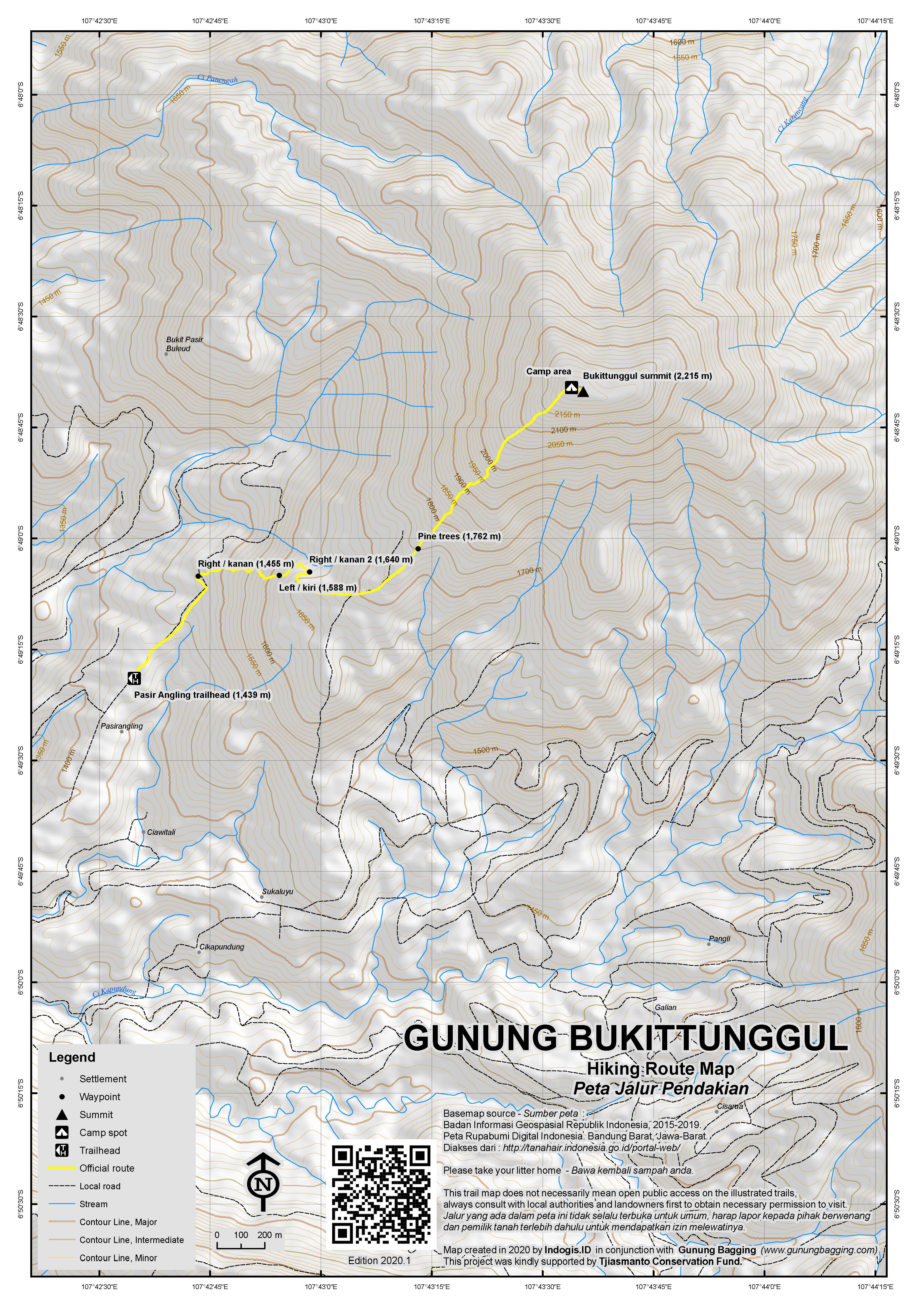
For a high quality PDF version of this and other trail maps, please download from our Trail Maps page.
Practicalities
- Getting there: For domestic flights from or to West Java, such as the airport in Bandung, we recommend Baolau. There is plenty of very basic public transport running between Bandung and Patrol/Cibodas. It takes just over one hour to drive from Bandung to the starting points.
- Guides and GPS Tracks: Want a PDF version for your phone? Looking for a guide? Need GPS tracks and waypoints? Gunung Bukittunggul information pack can be downloaded here.
- Trip planning assistance: Would you like Gunung Bagging to personally help you in arranging your whole trip? Please contact us here.
- Permits: Not required but take a photocopy of your passport photo page just incase.
- Water sources: Take sufficient supplies with you.
- Accommodation: Try the Booking.com map above or use this link to search for suitable hotels, homestays, resorts and apartments for your trip.
- We recommend Safety Wing as travel insurance for overseas travellers and tourists hiking up to elevations not exceeding 4500 metres.
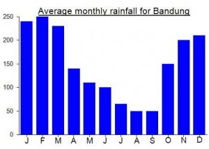
Local Average Monthly Rainfall (mm):
Location
Click on the blue arrow ![]() (top right) to see your current location on the map
(top right) to see your current location on the map
Origins and Meaning
Prominent Hill. In Sundanese tunggul means “tree stump” but also “to stick out above the surface”, “to be most prominent” (related to Indonesian word unggul = superior, like the English term “outstanding” or “standing out”). (George Quinn, 2011)
Climbed up Gunung Bukittunggal yesterday and it seems to be a bit more developed now vs when the posts above were written. At the end of the Pasir Angling road there is now a small charming rustic campground with plenty of space to park cars, toilets, a pond, and a warung. There you should sign the guest book and pay Rp 10,000 per person before hiking up to the top. They’ll also tell you about the trail and the area.
There are now allegedly 5 pos before reaching the peak, though we only saw signs for pos 1, 2, and 4. There’s a lovely ladder built into a tree that makes a great photo spot where pos 3 maybe would have been. There is some risk of losing the path in the lower stretches as there are farm and motocross tracks that cross it, but there are helpful arrows that the campground owners have put up at potentially-confusing intersections, so look out for those.
Our group took between 1 hour 40 mins and 2 hours 10 mins to reach the top from the campground/carpark, and then as little as 1 hour to come down. So it’s a fast ribu. But still a lovely one and made for the centerpiece of a nice day out.
It was strange being back here again after almost 8 years. My main memory of the first time was the soaked taxi driver and the plantation farm truck! The Pasir Angling route probably makes more sense but a traverse might be the best of all, assuming you don’t have to rush back to Jakarta (or wherever) too early.
–update 2015 (tricky Simpang)–
To reach the starting point, follow Dan’s instructions. Otherwise you can target on google maps :
Masjid Miftahul Falah Ciawi Tali
(The start is in this village)
Climb through the farmland and go up to this intersection :
GPS point.06.81987S/107.71460E
(If you don’t have GPS reader or smartphone, then it is basically the biggest obvious simpang that you will encounter 15 min after it starts to be steeper)
*If you take the left, then you will go to the “Jungle bashing” path.
*If you take right, then a trail (steep but clear) will lead you to the summit. (note that 600/700m further, you will need to take left to the smaller path on another intersection. Try to ask and target the peak if you aren’t sure.)
It took us 3h to go up (including breaks) and 2h to go down.
– The ascent is also possible from Dago Pakar, but it takes 1 or 2 more hours. We met on the top, hikers who were coming from there.
Completed Bukittunggul on the second day of a 2-day excursion to the Bandung/Lembang/Sumedang area, wherein my group climbed Tampomas the previous day. Maybe not the best idea in retrospect because by the time we climbed up Bukittunggul my legs were already sore! Nevertheless we pushed on but I had a very difficult time with the wet and slippery trail after the farming area. Much more steep than I imagined with at least a 60-70 degree pitch at some points. Combined with the January rains (again, not the best idea) and our climb down was very precarious. I had to resort to slipping down on my bottom for a fair amount.
Overall, Bukittunggul is not recommended for beginners or overly ambitious baggers trying to do 2 in a weekend 😉 Trail is challenging and very steep at parts; best to avoid during rainy season. That said if you are in good shape and trying to knock off two ribus in a weekend then it is definitely possible to do this plus Tampomas over the course of a normal weekend with the following itinerary:
-depart Jkt on Friday evening
-overnight in Bandung on Friday
-early Saturday morning start and drive to Tampomas (Sumedang)
-7 hour hike up and down (via Narimbang route), done by mid- to late-afternoon
-drive to Lembang and overnight in a hotel there
-early morning Sunday drive to Bukittunggul (15-20 mins from Lembang)
-6-7 hours up and down, done by mid-afternoon
-late Sunday afternoon bus back to Jakarta
I climbed Bukittunggul Sunday 28 April on a day trip from Jakarta.
If you leave Jakarta about 3 am you should be at the Pasteur toll road exit in Bandung by 5 am. From there it takes another hour or so to drive through Bandung up to Lembang and on to Maribaya and Cibodas, as described by Dan. There are a couple of hotels/ villas right in Cibodas if you want to stay the night close to the mountain.
We parked at the red Bukittunggul sign (actually a stone pillar) and then took ojeks to get as close as possible to what we hoped would be the correct entry point to the forest. Instead we were dropped in effectively the middle of nowhere and spent over an hour hunting round for a guide with some notion of the correct route to the summit. Learning from this experience, I advise as follows.
Instead of parking at the Bukittunggul sign, take the left fork past the warung and along the river for about 500m. Park beside the covered footbridge on the left and walk over to the dairy farming village of Cikapundung. You can look for a guide here or in the village of Kampung Asrama further up the hill. Our guide Yayan (HP: 087824411663) lives in Kampung Asrama.
The altitude at the footbridge is 1350m. Once you leave the village you have over an hour navigating through crisscrossing plantation trails to reach an altitude of 1800m. You’re sure to meet some farmers but probably not enough to keep you on the right track without a guide. Above 1800m the trail becomes steep, but it is always well-defined, with plenty of trees to use as hand supports. Three hours after leaving Kampung Asrama, you should be at the summit.
We met a group of campers who had climbed up the night before from a village called Legok Jero, which lies east of the peak. They suggested that the route from there is slightly shorter, but also hard to follow without a guide. They also told us that the prehistoric remains mentioned by Dan comprise only hollows which were dug out as sacred pools.
In 2 to 3 hours you can be back down in Kampung Asrama. After the hike, Maribaya hot springs is a lovely spot for a mie goreng, a beer and a soak in the hot or cold pool. In afternoon traffic allow 4 to 5 hours for the drive from Maribaya via Pasteur back to Jakarta.
Bizarrely, my taxi driver from Bandung decided to come with me on the trek still wearing his uniform and armed only with a bottle of Pocari Sweat and some kretek cigarettes! He soon regretted it. By the time we reached the point at which you leave the plantation track he was getting very weary and his uniform was totally covered in mud! Then a rainstorm began and he decided to wait behind near the farm track while I tackled the final 90 minutes of steep jungle-bashing to reach the peak.
I asked a local farm worker for help and he led me along what could definitely not be described as a clear path and up the steep sides of the peak itself.
On the way back down we managed to hitch a ride on the top of a farm truck blasting out dangdut music across the hillside and even saw several angkots far up the farm track collecting farm workers. My taxi driver then drove barefoot back to Bandung railway station in about 90 minutes – a fare I am sure he will never forget!