
Facts
- Elevation: 1,193 m (3,914 ft)
- Prominence: 790 m
- Peak category:
 Spesial
 - Region:
 Peninsular Malaysia
 - Malaysian state: Negeri Sembilan
- Range: Banjaran Titiwangsa / Main Range
- Coordinates: 2.8408, 102.0692
- Rating:
 (Bagged it? Be the first to rate it)
 Loading...
 - Other names: Also spelt ‘Telapak Burok’.
Bagging It!
The curiously-named Gunung Telapak Buruk, meaning Rotten Palms or Bad Palms Mountain (either hand palms or the soles of one’s feet!) is the highest point in a fairly large range that is known for being the site of a World War 2 plane crash. As the trailhead leads up via Gunung Berembun, most visitors to this area call it Gunung Berembun (Dewy Mountain). Some only trek as far as the top of Gunung Berembun (1,014m – also known as Berembun Jelebu to avoid confusion with other mountains of the same name), but many then drop down to visit the crash site on the trail towards Telapak Buruk. Few continue to the peak of Telapak Buruk itself.
There are actually two possible routes. The main one is from the Gunung Berembun ticket office in Kampung Pantai. The other is from the Telapak Buruk telecommunications tower which is near the summit of Telapak Buruk but requires a 4WD to make the rough journey along the access road. A traverse would be the most interesting, but most folk hike in and out via Gunung Berembun.
From Gunung Berembun trailhead in Kampung Pantai, the route goes via Lata Berembun and lots of rivers to Gua Kambing (after 90 minutes) and then on to Gunung Berembun peak (after a total of 2.5 hours). From there it is about 45 minutes on to the crash site. A return hike to the crash site only is likely to require 7-8 hours including breaks, but if you want to continue on to the peak of Telapak Buruk, allow 12 hours for the return trip (unless you can prearrange a pick-up at the other end!)
The RAF B-24 Liberator plane apparently crashed on August 23rd, 1945 shortly after the end of World War II when dropping supplies. Some sources state the exact spot was discovered in 1996 by Orang Asli but others say it was in 2009. The site was officially commemorated in 2012 and the crew were formally laid to rest.
Note on the many ‘Berembuns’! The reason we have listed Telapak Buruk rather than Berembun is two-fold. Firstly, because Telapak Buruk is the highest peak and can be reached in a long day-hike from the Berembun trailhead. Secondly, because there are so many Berembuns in Malaysia that it gets totally confusing. There’s a Gunung Berembun (1,840m) near Tanah Rata in the Cameron Highlands which can be hiked easily in 3 hours or so. There’s another Berembun south of the main Cameron Highlands road from Ringlet which is the highest of all the Berembuns at 2,076m and is not very popular, requiring more time to get to the top of, usually along with neighbouring Gunung Hantu (1,930m). It is also known as Wray’s Berembun or Berembun Wray, presumably after the British botanist who spent much of his time in Perak. There is also a ‘Lata Berembun’ near Raub, Pahang, which in previous years was the usual starting point for a trek to Gunung Benum but in 2024 remains closed due to a landslide. There are several more obscure peaks also named Berembun in addition to those mentioned above.
Bukit Bagindo (450m, with a prominence of approximately 326 metres) and the wave rock
Over ten kilometres to the east of Gunung Telapak Buruk is a fascinating hill named Bukit Bagindo (also spelt Baginda). It is located on the eastern edge of the Titiwangsa range, not far from the small town of Batu Kikir. Since 2018, a huge boulder with a wave pattern not far below the summit has become a popular place to visit. This deep and natural formation is stunning, and well worth the 2-3 hours required to visit it.
Until recently, the usual starting point for the short hike was via a rubber plantation to the south of the peak, but in 2024 this has been replaced with the Bukit Bagindo Gochang Eco Forest to the north-east of the peak. This new trailhead leads not only to the famous wave rock itself, but also to countless other named rocks and the hill summit. A local guide is available and can explain the history and meaning of the many features of interest along the trail.
The spelling ‘bagindo’ appears to be the official one now, despite currently being less popular than ‘baginda’. On the southern approach is a grave for Bagindo, with the year 1511, and this presumably relates to Raja Bagindo (or Rajah Baguinda) who spread Islam across the region as far as Sulu in the southern Philippines, or his followers from many centuries ago. Raja Bagindo originated in the Minangkabau region of West Sumatra, present-day Indonesia, and it is therefore fitting that many of the rock names have a distinctly ancient and Indonesian sound to them.
From Bukit Bagindo Gochang Eco Forest (132m), the trail to the top of the hill and the famous wave rock leads via several clusters of named rocks. First up is Batu Ombak, which is another wave rock, this time with small wave patterns on top of it, Batu Pancar Delima (‘delima’ being ‘pomegranate’ but pancar delima translating to ‘ruby glow’) and Gua Pancur Alam (‘natural fountain cave’). Most of the named rocks are impressive boulders either with natural patterns on the rock or resembling the objects which they are named after. Further up the hillside are Batu Ukir Naga Sari, Batu Arjuna Agung, Batu Keris Patah, Batu Ikan, Batu Bidai Sari, Batu Maya Bumi and Batu Wali Tujuh which can either be tacklied using a thick rope up the steep side of it or by bypassing the boulder but still using a rope on the left side. The trail then continues to climb up through forest.
Higher up the hillside is Batu Panca Dewi Sakti and then the summit (450m), which has a wooden seat to sit on and rest, plus a prominent sign. Most hikers should be up here in 90 minutes or so. There are no views. The famous wave rock is actually on the other side of the summit, so a very short descent of a few minutes is required via Batu Yam Tuan Hitam to the location of the most famous of the named rocks (448m). It is deservedly famous and there are several hiking clubs signs nailed to trees here.
Heading back down to the Eco Park trailhead takes less than an hour, especially if you use a shortcut near Batu Arjuna Agung.
Trail Map

For a high quality PDF version of this and other trail maps, please download from our Trail Maps page.
Practicalities
- Getting there: For Malaysian domestic flights and flights within Southeast Asia, for example to Kuala Lumpur, we recommend Baolau.
- Permits: RM5 per person at the Gunung Berembun trailhead.
- Water sources: Several stream crossings near the Berembun trailhead.
- We recommend Safety Wing as travel insurance for overseas travellers and tourists hiking up to elevations not exceeding 4500 metres.
Local Average Monthly Rainfall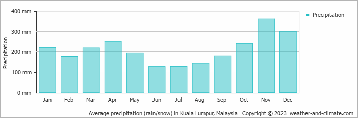
Location
Click on the blue arrow ![]() (top right) to see your current location on the map
(top right) to see your current location on the map
As Gunung Telapak Buruk remains closed (though the shorter option to Gunung Berembun only is now permitted) I decided to visit Bukit Baginda/Bagindo wave rock as a Plan B. I wasn’t expecting a particularly amazing day but it turned out to be fascinating. The Gochang route is the official one now and I could not have asked for a better or more enthusiastic guide than the official from the Eco Park. He led us via a large number of interesting rock formations, giving information on the meanings behind all the names, which unlike the crass Kem BMW and Kem Maggi type of names you find on Malaysian trails actually have some power and majesty about them. They felt rather ancient to me, and the guide himself made me think of certain Indonesian guides in Java who are not just ordinary guides but ‘juru kunci’ – the local custodians or key masters of the mountains, with a mystical element apparent.
We spotted a cobra on the way up, but thankfully only its tail. It was more yellow than black, and may have been a Sumatran cobra, which ties in nicely with the Bagindo history, though I may well have misidentified it. There were so many interesting rocks that I did not have time to sufficiently record them all in my GPS. I’m amazed the place is not more popular than it is already as it is a really great experience and one of the highlights of my 6-week trip. We were up in 90 minutes, including plenty of photograph time at the rocks, then 30 minutes back down when the staff really kindly treated us to some fruit including jackfruit (my current favourite), rambutan and durian.
Highly recommended – a fascinating and friendly place. Hopefully Telapak Buruk will be open in 2025.
Hi, would like to know whether we able to hike here or it is still closed for the local. Planning to start trip this Saturday
Hi Nik. Yes, correct, still closed but possibly reopening soon. I have it pencilled in for next July/August so if you are interested just email me. Dan
Did you hike to the crash site already? If yes, can let me know if trail visible? Thank you
Hi Lydia. Not yet. I’m in the UK again now but plan to hike it in July or August next year. Please email me if you are interested in joining. I am not sure it is open yet but I am fairly confident it will be open again by next summer. Dan
Thanks, just found out they open already. Will hike to crash site soon
A Gunung Bagging trip to Gunung Telapak Buruk is likely to happen 2nd August 2023. If you are interested in joining please reply to this message ASAP or contact via the contact page. Thanks, Dan.
Hey Dan! I thought the track was closed since 2021 because of major flood. Otherwise, I’m interested to join you!