Facts
- Elevation: 2,102 m (6,896 ft)
- Prominence: 1,382 m
- Ribu category: Tinggi Sedang
- Province: Lampung
- Google Earth: kml
- Rating:
- Other names: none
Photos
Bagging It!
Gunung Tanggamus dominates the landscape around Kota Agung on the beautiful, scenic western coast of Lampung. From Kota Agung it appears as a pyramid of jungle with broad lower slopes tapering up to a tiny summit area. It is rarely climbed by anyone other than local students at weekends but the trail is, for the most part, incredibly clear, easy to follow and not eroded. There is very little litter too which makes a nice change and the relative remoteness of the area means that the forest is full of animal and insect life, especially if you ascend at night. However, there is actually little point climbing at night in time to see the sun rise from the peak. As is the unfortunate case with other non-volcanic peaks of a similar height in Indonesia, this is because what would be a fabulous viewpoint to other Lampung mountains and the complex western coastline nearby is completely obscured by tall, dense bushes and moss-covered trees. So, ultimately it’s a nice trek through relatively undisturbed jungle but hard to recommend on its own merits for anyone other than people who have climbed every other hill within weekend striking distance from Jakarta, local naturalists, or those who simply want to climb all the Ribus, regardless of whether or not you get a decent view! Definitely a case of the journey being more important than the destination!
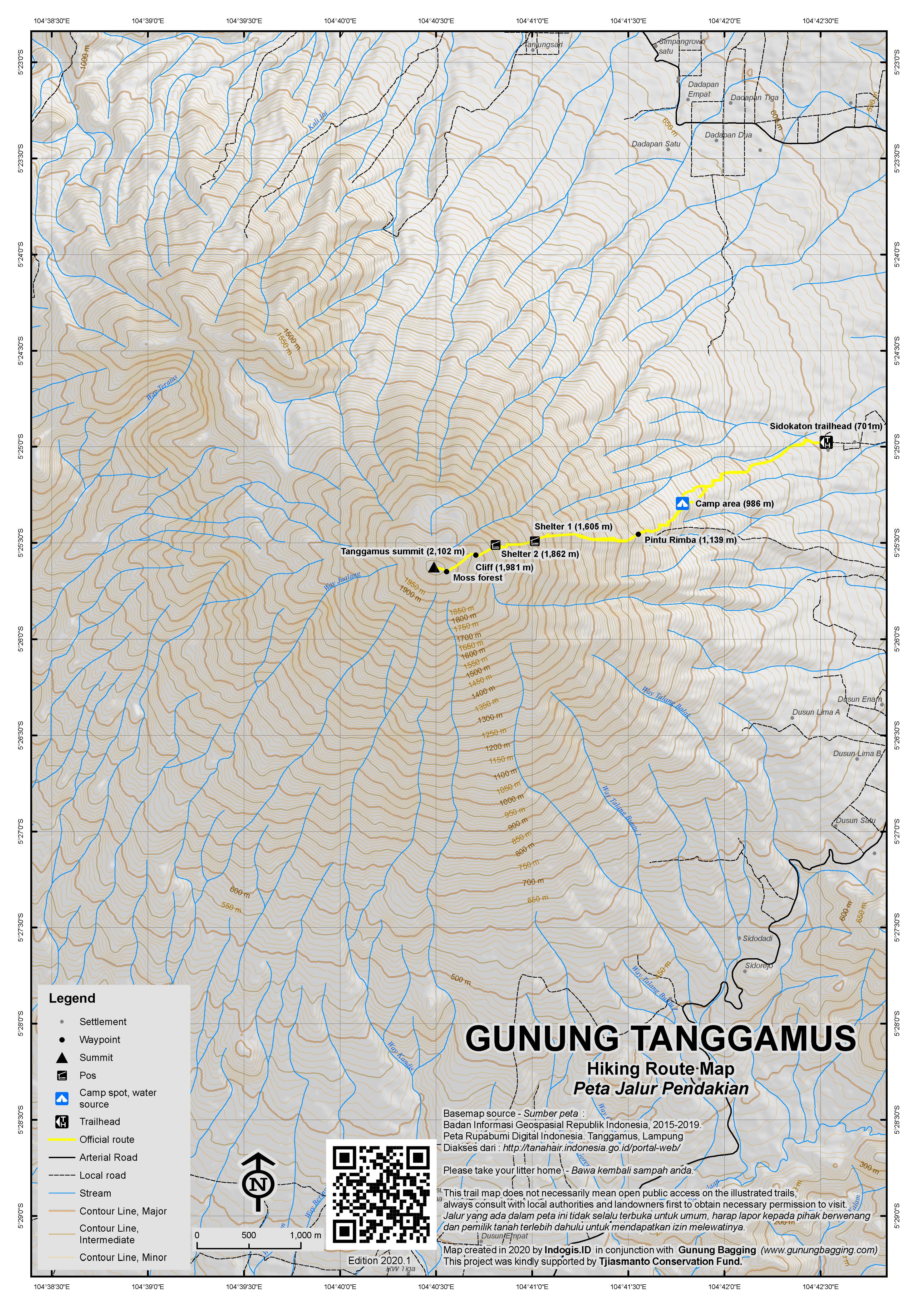
There is a trail from Kota Agung but the best-known and most well-used trail starts at the end of the road in the village of Sidokaton (701m) which is about 15 minutes by motor vehicle from the main Bandar Lampung-Kota Agung road at Gisting. There are no signposts so you will probably have to ask local people for directions. From Bandar Lampung it take about 2 and a half hours to reach the trailhead. Please call in at the last building on the right which is a warung (small shop) to let them know you’re climbing and ask for a local guide if you haven’t already arranged one in a nearby town. A guide is definitely essential as there are many trails on the lower slopes through farm plantations and it’s impossible to know which turnings to take.
After less than an hour you will have reached a camping ground (986m) popular with friendly local youngsters who like to spend Saturday evenings singing reggae songs round a campfire. Shortly after this spot, the path becomes much more obvious and there are less trail junctions. There are some great views to the coast and other nearby hills – the last decent views you will get before entering the dense forest (1,139m). The trail becomes steeper and steeper as the trail continues up the cone-shaped mountain but it is in good condition and the only difficulty at this point is the roots of trees which are easy to trip up on.
Somewhat oddly, there are two signposts for Shelter 1 (1,605m) and Shelter 2 (1,862m) but there are no buildings and there are much better places elsewhere to pitch a tent if you really need to. The jungle is alive with animal life at this point – a variety of lizards, monkeys, and huge red ants call this place home and pythons have even been spotted here! After the sign for Shelter 2, the trail gets increasingly moist and all the tree branches are covered in wet moss. There are some tricky sections where you have to scramble up flat, vertical rocks but there is no great danger of serious injury. At the most lengthy of these, there is a rubber rope tied to a tree to help you drag yourself up the tiny rockface (1,981m).
By this point the trail has deteriorated to a narrow path leading over slippery logs which seem to have been placed there deliberately by some malevolent being intent on making your progress up the mountain as troublesome and slow as possible! This continues right the way up to the summit and seems to take forever! After about 5 hours you should have reached what ought to be the finest viewpoint in Lampung province. Unfortunately, there is no view due to the vegetation – all you get is a small grassy opening with a couple of summit signs and the remnants of a small campfire. You can try climbing a nearby tree but it’s impossible to get high enough to see above the tall branches of other trees. A real shame and huge anti-climax, especially if, like us, you were hoping to watch a beautiful sunrise from the peak! You will see a second trail heading down to the west towards Kota Agung from the summit, but it is probably a lot more overgrown than the Sidokaton route.
After wallowing in the disappointment of a lack of view, it should take you about 4 hours to return back down to Sidokaton.
Bagging information by Daniel Quinn
Trail Map

For a high quality PDF version of this and other trail maps, please download from our Trail Maps page.
Local Accommodation
Practicalities
- Getting there: Best to hire a car or motorbike from Bandar Lampung or otherwise expect a long journey on public transport.
- Guides and GPS Tracks: Want a PDF version for your phone? Looking for a guide? Need GPS tracks and waypoints? Gunung Tanggamus information pack can be downloaded here.
- Permits: Not required but let the locals know you’re climbing and when to expect you to return.
- Water sources: Available at the camping area (986m).
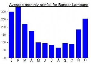
Local Average Monthly Rainfall (mm):


Myself and Mr Whiting will be attempting this one later this month. The google translate description of the hike is pretty amusing….
“Without being felt, we finally located in the forests of moss with temperatures below 15 degrees Celsius. As far as the eye could see, moss looked everywhere. Drops of water rolling off its surface, falling in the most clear form. We took turns to suck water from the moss, because drinking water supplies have been demolished.
The trunks of trees that fell, too full of moss. This slows down our journey, having to be extra careful. Slip a little, can slip, and the mountain slopes with a slope of 50-60 degrees is ready to swallow us. Not to mention the lumps and lush rock rattan trunks full of thorns.”
Thanks Ben. Looks like it is potentially doable in a weekend from Jakarta…let me know if you have plans…
Found some info on Tanggamus here:
http://www.google.co.id/imgres?imgurl=http://lh5.ggpht.com/_J2S7B_1JIAo/R_t72w0Oy_I/AAAAAAAAAPQ/KOoOYK4vpkc/Gunung%2BTanggamus%2BPagi%2BHari.jpg&imgrefurl=http://aqillah-aqillah.blogspot.com/2008/12/dalam-dekapan-kabut-tanggamus-may-10_14.html&h=930&w=1600&sz=263&tbnid=jPFUnc6PYBx3_M:&tbnh=87&tbnw=150&prev=/images%3Fq%3DTanggamus&hl=en&usg=__azR61QJpPBVn-gRGdZyD_SmAN0w=&ei=OB-0S4PaF8S_rAe7uu1B&sa=X&oi=image_result&resnum=8&ct=image&ved=0CCMQ9QEwBw