
Facts
- Elevation: 2,579 m (8,461 ft)
- Prominence: 844 m
- Peak category:
 Spesial
 - Region:
 Sabah
Sabah - Range: Banjaran Crocker
- Division: Bahagian Pantai Barat
- Coordinates: 6.2039, 116.6597
- Rating:

 (1 votes) Add your rating
 Loading...
Photos


Bagging It!
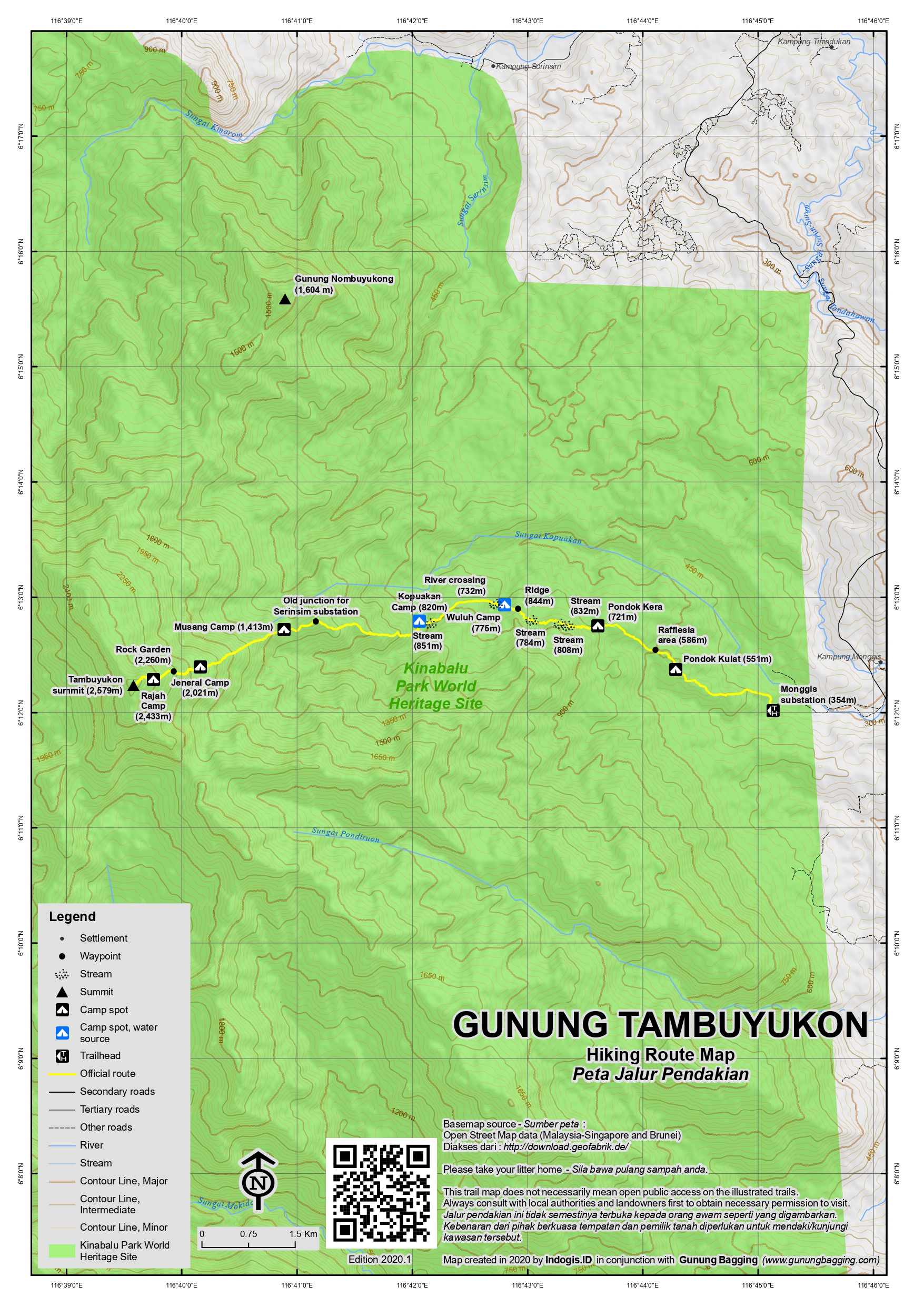
Tambuyukon is regarded by many hikers as the fourth-highest mountain in Borneo (and in Malaysia, and in Sabah!), but it is dwarfed by the huge Kinabalu which is in the same area just 12 kilometres to the south. However, a hike to the top of Tambuyukon is much more time consuming and more difficult than a hike to the top of Kinabalu and far fewer people attempt it. Gunung Tambuyukon lies with the Kinabalu Park area.
The trail starts at Monggis substation (354m) about 60km from Kinabalu Park HQ where you need to arrange permits. In the past, a 4WD was required to reach Monggis substation but now it can be achieved in ordinary cars though care is required on the final 2 kilometres of stony track. Monggis is a pleasant though isolated spot, with a simple, roofed cement enclosure with electricity for groups to potentially sleep in (in their sleeping bags and even tents) the night prior to starting. There is also a fairly nice building for Kinabalu Park staff members working here plus a toilet block.
Most hikers still take four days to complete this trek, though it can be achieved in three days quite easily if you are ok with a long day on your second day from Kopuakan. It can even be done in two days by those who are not that bothered about sleeping at night but the terrain is such that being tired here could be dangerous in some areas. Whatever you are planning, unless you are starting in the afternoon on the first day, ideally you want to get at least as far as Kopuakan, which is good due to the water source and a simple roof and shelter, or even Musang, which is no good for water or a shelter but is a nice spot to pitch a tent and means you are already a good way towards reaching your goal. Anything beyond Musang is not massively recommended unless you like cold nights or prefer to carry all your stuff almost to the top instead of using a headtorch and starting pre-dawn.
The hiking trail starts at a landscaped area called Nickel Garden near the staff building. A trail map suggests that the trail is 14km in length (one way) but it certainly feels considerably longer! The trail leads via Pondok Kulat (551m) which is just beyond a large pool of stagnant water and features no shelter in 2023, Pondok Kera (721m), then several minor stream crossings before reaching what feels like a ridge (844m). Sadly, the trail leads down from this point to Wuluh Camp (775m), shortly after which is a fairly serious crossing of the Wuluh river (732m). Kopuakan Camp (820m) is next and is the most common place to camp as there is a small wooden shelter and a good water source from the Kopuakan river. The number of ups and downs on the trail as far as Kopuakan can be not just physically exhausting but mentally exhausting. It is probably best to think of Kopuakan as the real ‘basecamp’ for the ascent as the trail prior to this point is just getting you to a location suitable and close enough to the peak for you to hike it.
Once across the Kopuakan river, usually very early on Day 2, sometimes as early as 1am, the trail starts the proper ascent, passing via the old junction for the Serinsim substation (1,435m) which is a side trail no longer used and then Musang Camp (1,413m) which is a very pleasant forest ridge. Further up you will begin to see pitcher plants (‘periuk kera’ in Malaysian), apparently the Nepenthes Villosa, Burbidgeae and Edwardsiana species can be found up here, and some look simply outlandish.
Eventually you will find yourself at Jeneral Camp (2,021m). By this stage you will have noticed how the vegetation changes and the terrain becomes more and more challenging, with logs to clamber over or squeeze beneath and thick mud that is almost impossible to avoid. It is virtually impossible to travel quickly through this terrain.
And this trend continues as you reach Rock Garden, a large and extensive area of sharp rocks from around 2,260m. A slip here could be very painful, and some sections require extreme care. Go slowly, and remember you are making progress, however slow that progress is! If you are lucky with the weather then the dwarfed vegetation will allow you some beautiful views. Eventually you will reach Rajah Camp (2,433m), but it is not especially large and anyone thinking of camping here will have to bring their tents across the rocks at Rock Garden which is making a tough job considerably tougher still.
Finally you will be at the summit sign, which in 2023 was about 20 seconds short of the true highest point of the mountain. Alas, the summit vegetation does not quite allow views but if you are lucky and have good weather you will be able to have wonderful views of Kinabalu from just a few minutes beyond the summit on the other side.
And then the long and careful trek back to Musang or ideally Kopuakan begins.
Strong hikers should be able to get back to Monggis on Day 3 with no problems.
If you are hungry for more in the area, note that an easier, lower peak in the northern foothills is Gunung Nombuyukong (1,604m) which can be hiked in two days from Serinsim by fit hikers.
Bagging information by Dan Quinn (August 2023)
Trail Map
For a high quality PDF version of this and other trail maps, please download from our Trail Maps page.
Practicalities
- Getting there: For Malaysian domestic flights and flights within Southeast Asia, for example to Kota Kinabalu or Kuching, we recommend Baolau. The nearest airport is at Kota Kinabalu around 3 to 3.5 hours away, 150-175km away depending on the route you take.
- Guides and GPS Tracks: Want a PDF version for your phone? Looking for a guide? Need GPS tracks and waypoints? Gunung Tambuyukon information pack can be downloaded here.
- Permits: Required from Kinabalu Park HQ. Email kinabaluoperationcentre@gmail.com for details. As of 2023, permits are RM300 per day for foreigners and RM150 per day for Malaysians, and guides (for up to 3 hikers) are RM175 per day. Entrance fees are RM50 for foreigners and RM10 for Malaysians. Campsite fee is RM20 for foreigners and RM10 for Malaysians (per night).
- Water sources: Plenty of water sources along the trail as far as Kopuakan Camp.
- We recommend Safety Wing as travel insurance for overseas travellers and tourists hiking up to elevations not exceeding 4500 metres.
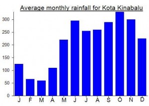
Local Average Monthly Rainfall (mm):
Location
Click on the blue arrow ![]() (top right) to see your current location on the map
(top right) to see your current location on the map
Tambuyukon was the toughest hike I did in Sabah last month. Around the same time I heard about a local guy who was advertising a ‘day-hike’ here. I wonder how he got on with that!
There is a fair bit of admin involved, and all at Kinabalu Park near Kundasang, where I went after descending Gunung Nungkok. It’s a shame that so much money is made out of Kinabalu yet there always seems to be a problem. The first time I came here, over a decade ago, they had run out of guides, even though they force people to reserve months in advance. In the end I signed a waiver and just set off without a guide as Kinabalu trail is so obvious you would have to be trying to go the wrong way to lose the trail.
This time, for Tambuyukon, getting a guide was 100% essential for what is a very different sort of trek. It is not immediately obvious how to sort this out online, aside from paying some third party a huge sum of money to arrange it, but eventually I got hold of the email address to sort it out. Upon arrival, it was lunchtime, so I had to wait an hour for the office to re-open. Note that it closes on 5pm Monday to Friday, but at 3pm on weekends. As they knew i was coming, the paperwork “only” took about 30 minutes. You definitely need to arrange this one well in advance because of the bureaucracy.
Sadly, there was then a powercut and no backup like a generator, even in a place as famous as this, so they couldn’t use the photocopier to do what they needed. Thankfully, they got it sorted out another way, by being flexible, an essential skill really if you can’t rely on electric power. And with paperwork done, I drove round (via a quick pleasure-stop at KFC Ranau) to Monggis substation, which took about 1 hour and 20 minutes and was quite deserted aside from the ranger. Pleasant but isolated. The only thing you don’t pay for at Kinabalu Park office is the guide fee, and as it has been customary in the past to need 4 days you are still expected to pay the guide – directly, after the hike – for 4 days at RM175 per day. It’s ok, but 4 days really are not required for this.
There’s no 4G or anything at Monggis but plenty of parking and some plugs to at least charge your phone. I met Jenol my guide and we ate before having an early night.
The highlights on day 1 were probably the large number of hornbills. So many of them overhead. There were some rotting Rafflesia around 3km into the trail and also something like a civet which darted off as soon as it noticed us. Although several of the early checkpoints as called Pondoks, there is little left of them, with the original shelter having rotted down into a few blank of wood lying on the floor. It’s a shame but i can see why camping only 1 or 2 hours away from the trailhead is not all that attractive.
Our original plan was 2 nights at Musang camp, but Jenol suggested 2 nights at Kopuakan as it has water, a higher temperature, and means less lugging of tents to higher up. It also has the only shelter with a roof on the entire trail in 2023, and one that could get full easily by a group of more than 5, so you still need to carry a tent in here just in case you are beaten to it.
The downside to staying at Kopuakan for 2 nights instead of Musang is of course that Day 2 is a very long one, starting at midnight and usually finishing well after12 noon. That long day sandwiched between 2 days of only 4 hour hikes. So I agreed.
Just prior to Kopuakan, my guide claimed to have seen an orangutan, perhaps at an elevation of 750m. I didn’t think they bothered heading the sides of mountains, but I did see a flash of the red-orange colour so… maybe, but not entirely sure based on that glimpse. A group of hikers from Peninsular Malaysia arrived mid-afternoon on their descent from the peak. They seemed exhausted but pleased to have got it done safely and had got a view of Kinabalu for 5 minutes at dawn before the cloud enveloped it completely. I too was exhausted, despite the short day of hiking.
Just before dusk there were some really strong gusts of wind that funnelled down the side of the mountain, following the course of the river in front of the camp. It was a little bit scary. The storm in the Philippines was still in control of the weather here and I was a bit concerned about our midnight trek. As were the local guides who kept checking to see what was going on, trying to find some pattern in what appeared to be random gusts now and again. When it blew, the vegetation on the opposite side of the river appeared like something on a stage set, made of material, a facade or front behind which there might be technicians. Or perhaps I was just seriously in need of some sleep!
We got started on time, and indeed there were a lot of branches swinging, a few twigs falling, but nothing to prevent our progress. On Kinabalu in these conditions I imagine it would just be closed or cancelled. The ‘land below the wind’ was not below the wind this week. Not at all. Beyond Musang camp the wind died down a lot, presumably due to the topography. We must have been sheltered from it for a while.
But the trail got progressively more like an obstacle course. First with trees and mud and then with sharp orange rocks that lead much of the way from Jeneral to Rajah, neither spot a winning campsite. Great pitcher plants here, looking almost fake. Big red plastic things dangling off branches. And then the rain began as we were nearing the top so there was no view at all. Exhausting but we had done it. 6:45 from Kopuakan. My GPS read around 2,578/2,579m. We lingered for all of 3 minutes then legged it back down, reaching Kopuakan by 1140am, not bad. Knackered. We considered continuing to Monggis the same day but decided on the following morning as we had been going non-stop since midnight.
Lovely weather the next day. And just 3:40 up and down to Monggis. I spoke with William Dius, the warden or ranger, after he gave me yet another hiking certificate, this time with a figure of 2,575.52m on it, lower than the summit sign and my GPS up there. He said that they had recorded 2590 on a GPS at the top. They are usually around 10 metres max from the reality, so perhaps 2579m just about reasonable still, otherwise Sinsing at 2,586m would get nudged into fourth place! William also showed me some amazing photos of Kinabalu taken just beyond peak in the early morning, with low ‘bonsai’ vegetation. But those views require great weather.
A memorable trek, and one which marked the end of the bad weather in Sabah. Thankfully!
A Gunung Bagging trip to Gunung Tambuyukon is likely to happen 14-17th July 2023. If you are interested in joining please reply to this message ASAP or contact via the contact page. Thanks, Dan.