Facts
- Elevation: 2,450 m (8,038 ft)
- Prominence: 1,133 m
- Ribu category: Tinggi Sedang
- Province: Sumatera Utara (North Sumatera)
- Google Earth: kml
- Rating:
- Other names: none
- Eruptions: 1600, 2010, 2013-21
Photos
Bagging It!
Gunung Sinabung is a beautiful conical mountain, and due to its close proximity to Medan is one of the most popular hikes in Sumatra. August 29th 2010 saw the first eruption of Sinabung since 1600 which led to thousands of local people being evacuated from their homes. As of December 2010, the peak was open for hiking again. However, the volcano started erupting again in September 2013 forcing local people to evacuate once again. At the time of writing (December 2013) the volcano remains dangerously active and it is not known when it will be safe to climb again.
Brastagi is a nice place to hang out for a couple of days and has cool weather because it’s 1,500 metres above sea level. One thing you must do is take a walk up to Gundaling hill which only takes 20 minutes or 5 minutes in an angkot. Aside from the touristy stalls and the constant flow of local people wanting to take a picture with you this hill offers great views of Sinabung and the other popular mountain nearby called Sibayak. It’s a great place to watch the sunset as the sun drops behind Sinabung. There’s plenty of accommodation in Brastagi for all budgets and your best bet would be to ask your hotel to organize a guide for you. Be wary of guides trying to rip you off, particularly on the transport side.
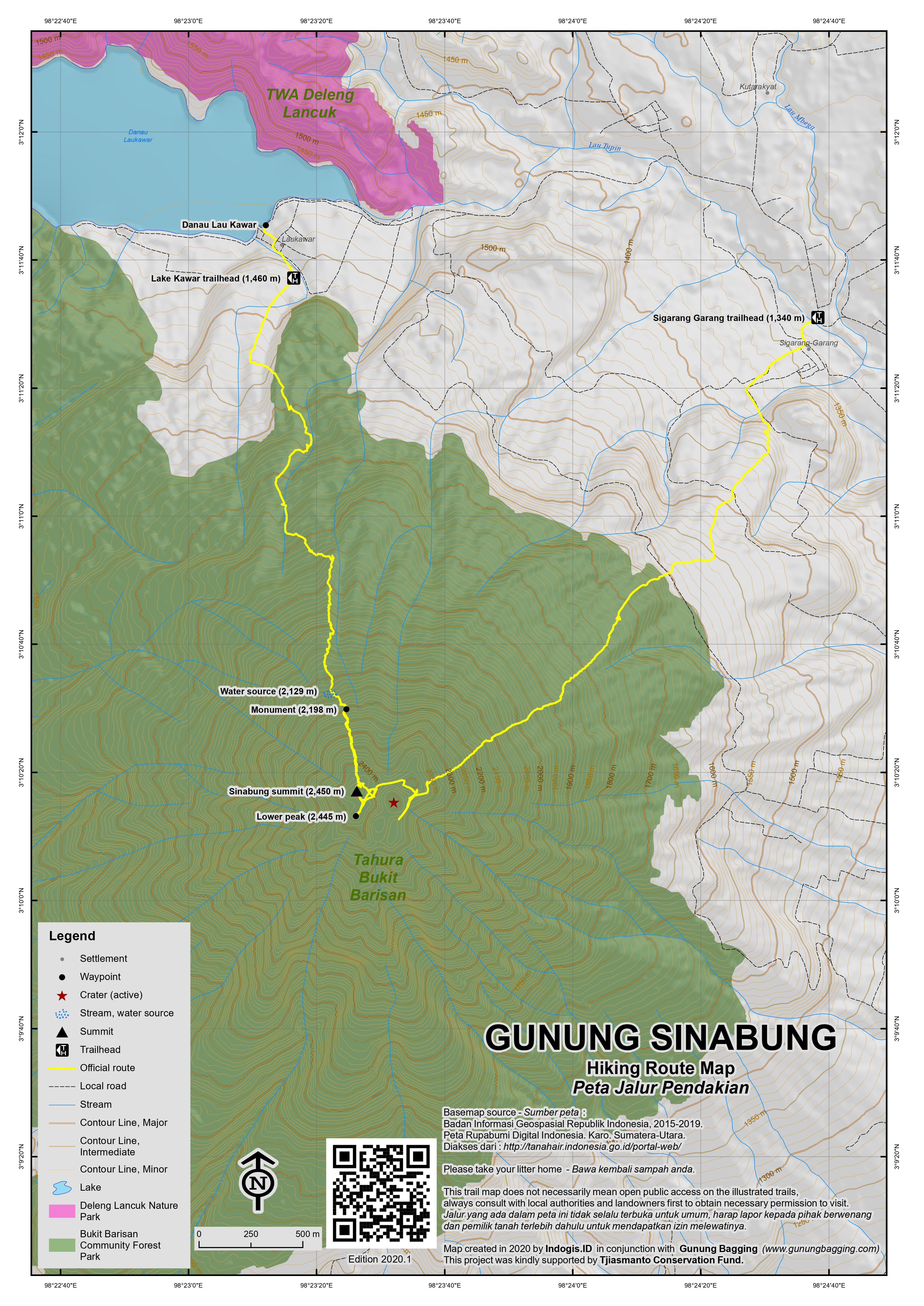
The route for Sinabung starts at Lake Lau Kawar (1,460 m) which is just under an hour’s drive from Brastagi and is north of the volcano. There’s not really a lot of action around Lake Kawar, just a few farms, so going to Kawar and looking for a guide would be risky if you are on a short time frame. If you climb during the day then it is possible to get an angkot to Lake Kawar but if you do the usual night climb to get to the top for sunrise then you will have to organize your own transport from Brastagi. Hopefully your guide will organize this for you.
The climb can be divided into three parts. The first hour of the climb is through dense jungle which is loaded with bugs. At night all the moths will swarm towards your face because of the light on your head torch. Better to keep your mouth closed or you will be choking on them. There are tree species name tags (in Latin) and shelter signs but no shelters. The trail meets a stream at around 2,129m. As you get higher the bugs go away and the track gets steeper. This part of the hike is quite muddy and expect the odd leech. Try not to step on the frogs. As the forest recedes, there is a small monument to a lost hiker (at 2,198m) after which the track becomes a rocky gully and for the last hour of the hike you will feel more like a rock climber. But this is the fun part! Then you will arrive directly at the summit where a huge expanse of craters will lie in front of you. In good weather you can see stunning views of Lake Toba, Leuser National Park, Brastagi and Gunung Sibayak. It is worth it to explore the crater area as there are a lot of fumaroles and a new gash in the ground near the impressive jagged rock that was formed after the recent eruption. There is a constant plume of smoke coming from the gash and it would be unwise to get too close to this. The true peak has a small cement monument on it, but it is worth visiting the second highest peak (just 5 or 10 metres lower) for the best views of the new crater and the plume of smoke.
The clouds will likely roll in early so best to time your climb for sunrise. I would allow 4 1/2 hours to climb and 3 back down but fit climbers will easily reach the top in under 4 hours. Do remember to take a jacket with you as it can get very chilly at the top while you’re waiting for the sun to come up. Once you arrive back down at Lake Kawar it is best to walk the half hour back to the main road if you don’t already have transport arranged. There you will find angkots to take you back to Brastagi.
There is an alternative route from the northeast at Sigarang Garang (1,340m) but it remains less popular.
Bagging information by Chris Whiting, updated by Dan Quinn (December 2013)
Trail Map

For a high quality PDF version of this and other trail maps, please download from our Trail Maps page.
Local Accommodation
Featured Guides
If you are a reliable local guide and would like to be featured on this page to increase your bookings, or a tourist who would like to support the development of a local guide business, please email danpquinn@gmail.com with the following information: Mountain name, guide name, guide location, guide contact details, and at least one English language review from a previous hiker who was pleased with the guiding services. An example is given below for reference. We have a maximum quota of 3 featured guides for each mountain page on the site. The fee for this is £20 (British pounds sterling, typically via the Wise app or PayPal) for a period of 1 year and helps to pay towards the ongoing development of the Gunung Bagging project.
- Name and location: Pak Budi, Surabaya, East Java.
- Contact details: +62812xxxxxxxx, budi@gmail.com, https://www.instagram.com/budi_mountain_guide/
- Review from previous client: “Budi was a brilliant guide for our September 2023 trek up Gunung X and I would definitely recommend him to other tourists“, John, USA.
Practicalities
- Getting there: If you arrive at Kualanamu airport, take the train or a taxi into the city and from there to Padang Bulan. From here buses run frequently to Brastagi (2 hours) and will only cost Rp 15,000.
- Guides and GPS Tracks: Want a PDF version for your phone? Looking for a guide? Need GPS tracks and waypoints? Gunung Sinabung information pack can be downloaded here.
- Trip planning assistance: Would you like Gunung Bagging to personally help you in arranging your whole trip? Please contact us here.
- Permits: None required but take a photocopy of your passport photo page just incase.
- Water sources: Usually available just 5 metres from the trail at 2,129m. Take sufficient supplies with you.
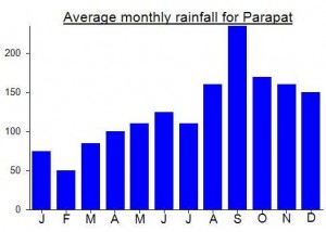
Local Average Monthly Rainfall (mm):

Location
Origins and Meaning
Cliff mountain (Geleng, guide from Brastagi, 2011)


 (9 votes) Add your rating

If we don’t want to Medan is better to use Airport Bus to Kabanjahe, a 11 kilometers from Berastagi with cost only Rp.60,000. Save time and save money
Some serious activity at Sinabung this week….
http://www.thejakartaglobe.com/news/indonesian-volcano-spews-towering-column-of-smoke/
Pingback: Berastagi – Journey Day 2 (Gunung Sinabung) | Adventure Vacation Trip
I climbed Sinabung last week and I cannot imagine there being a more interesting mountain in North Sumatra. We climbed at night and for the most part had excellent weather so by the time we reached the top the views were spectacular, especially of the new crater which is just a small gash in the old crater wall but sends out a near-continuous stream of white gas into the air. It took just over 4 hours to the true summit and about 3 hours to descend. Just before our descent down to Lake Kawar, we spotted a small owl having trouble flying, presumably injured and/or disorientated.
My GPS gave a reading of about 2450m at the true peak (crowned with a cement monument) and so I reckon Sinabung is indeed North Sumatra’s second highest peak (after Sibuatan at 2457m) and will be amending all relevant website data at the end of 2011.
For guides, it was a little more difficult and expensive than I had anticipated. There are certainly plenty of losmens and even a tourist information centre in Brastagi. However, the tourist information centre asked for 800,000 for a guide and transport – a price which I found a bit steep. When I said this, they quickly asked me how much I wanted to pay (!) but I told them to forget it after they’d tried to rip me off!
I asked around at the losmens instead and Sibayak Losmen arranged a guide for me (though they weren’t very forthcoming when I repeatedly requested the HP number for our guide). I would recommend contacting Geleng directly (number will soon be on our guides page) because he seems to be the local man who is the first person contacted when a tourist wishes to climb Sinabung or Sibayak. His English is good and he is mildly obsessed with Cockney rhyming slang. He certainly knows the mountain. Expect to pay about 250,000 for guide plus 350,000-400,000 for angkot transport to/from Lake Kawar (27km each way).
A fabulous mountain that really lived up to my expectations after reading Chris’s report.
great owl pic dan.i noticed that the guide has the same clothes on that he was wearing when he took me up.i hopes hes washed them.did your other half make the trip?????
yes she did, but calling her my ‘other half’ is a bit premature! i’d like to find out what type of owl it is!
Hey Dan! I’m writing an article about climbing Sinabung and it would be awesome if I can ask you a few questions about the climb? Maybe we can feature each other on our respective platforms as well. Let me know! 🙂
Sure. DANPQUINN at GMAIL dot COM but the gunung is clearly closed for now for obvious reasons…
Hi Dasmir – a very interesting question. I have only ever seen Sibuatan listed as 2457 but I have seen different figures for Sinabung ranging from 2412 to 2475. The most common is 2460 (Wikipedia and many other sources) and this broadly fits in with our SRTM analysis. We were never able to check the Bakosurtanal data – because we had problems with the staff at the offices in Cibinong. I will be climbing them both in April with a GPS so I should find out more then.
Hi Dan,
Just wanna know which is higher, Sinabung or Sibuatan? In some other references in some web, Sibuatan is higher.
May I know which is your reference?
Thanks,
Dasmir
from what i saw there seemed to be only 2 main craters and a hole next to the big rockface where the smoke is coming out.i guess you could deem that as a crater.my guide also told me that after the recent eruption there were 8 craters instead of the previous 2. but when he showed me what he meant .they were kind of muddy pools of water that were inside one of the main craters.
What’s this I hear about there being 8 craters instead of the previous 2? Correct?
i have word from a guide in berastagi that it is safe to climb sinabung. i will find this out first hand next week.
Another eruption this morning….
http://www.thejakartaglobe.com/home/indonesian-volcano-spews-new-burst-of-ash/394361
A fascinating image gallery from the BBC website…
http://www.bbc.co.uk/news/world-asia-pacific-11126417
Some interesting news reports on the August 29th 2010 eruption of Sinabung….
http://www.thejakartaglobe.com/home/volcano-erupts-on-indonesias-sumatra-after-400-years/393405
http://www.bbc.co.uk/news/world-asia-pacific-11123169