
Facts
- Elevation: 3,726 m (12,224 ft)
- Prominence: 3,726 m
- Ribu category:
 Sangat Tinggi
 - Province:
 Nusa Tenggara Barat
 - Island: Lombok
- Coordinates: -8.4117, 116.4581
- Rating:

 (52 votes) Add your rating
 Loading...
 - Other names: ᬕᬸᬦ᭄ᬗᬸᬂ᭞ᬭᬶᬦ᭄ᬚᬦᬶ (Sasak), originally Samalas
- Eruptions: 1847, 1884, 1900-01, 1906, 1915, 1944-45, 1949-50, 1953, 1965-66, 1994, 2004, 2009-10, 2015-16
- World Ribus ID: 69003
Photos


Bagging It!
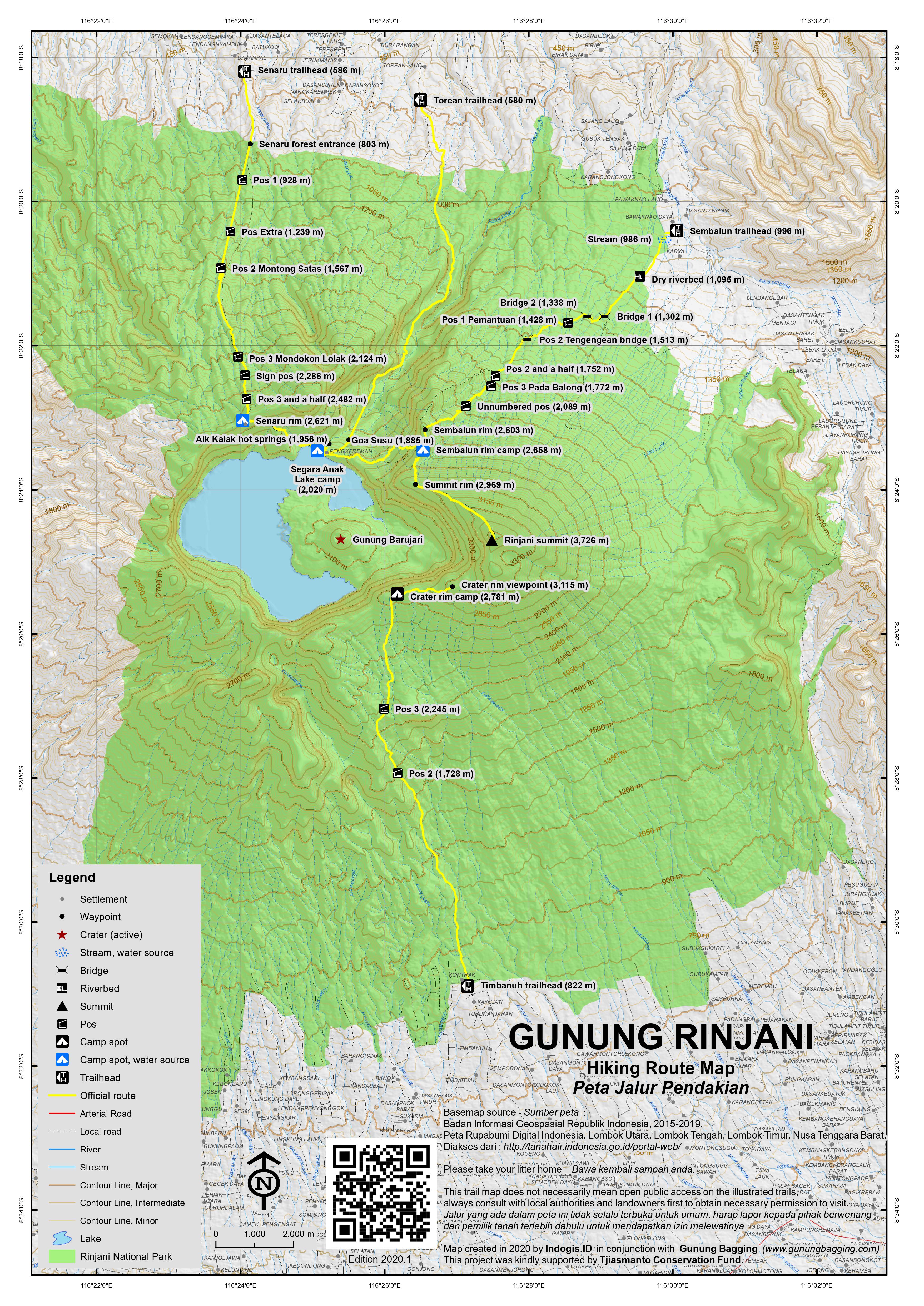
Mount Rinjani is the second highest volcano in Indonesia (after Sumatra’s Mount Kerinci) and easily one of the finest and most popular treks in Asia. The volcano complex, previously known as Samalas, is now thought to have been the location of an enormous eruption in 1257 which caused climatic change across the globe (the ‘little ice age’) and left the huge caldera which we see today. There are several routes through Mount Rinjani National Park (entrance fee 150,000 Rp for foreigners). Most hikers choose to start in the north at Senaru (a village with plenty of accommodation and information on routes) and camp at the crater rim with the most spectacular views over Segara Anak (Child of the Sea Lake) and the active new volcano Gunung Barujari which is about 200 years old. However, Sembalun to the east is the better starting point for hikers wishing to reach the rocky summit.
The best trek is a 3 days/2 nights hike from Sembalun to Senaru – from the garlic-covered village of Sembalun through the savanna-esque plains and up to the campsite beneath the puncak, visiting the summit at dawn, then the second night either down at the lake or beyond up at the Senaru campsite, before descending to Senaru on the third day. It is possible, however, to head up to the summit from Sembalun and back down the same way. This would only require spending one night camping. Those wishing to visit the smoking cone of Gunung Barujari in addition to the regular Sembalun to Senaru hike are advised to spend an extra night camping at the lake (i.e 4 days / 3 nights).
Should you wish to book a completely guided trekking trip to the summit of Rinjani, then you will easily locate several shops offering fully organised tours in Senggigi, including overland transfer, guides, national park entrance fees, tents as well as food. A three-day, two-night trip will cost roughly US$200-230 per person, not including a well-deserved tip for the porters and guides, although prices can be higher for single hikers or couples. Many websites offer advance booking for ‘deluxe’ (slightly more sophisticated food) and ‘standard’ (fried eggs, noodles, potatoes, fruit etc.) packages, but the quality of the service can vary enormously and the prices quoted online are generally rather more expensive than the prices you will find in person in Lombok itself. It is also important to consider what percentage of the payment will actually be set aside for the guides and porters themselves who are often from very poor villages. The fact that you are already paying quite a lot makes one wonder why a tip (or just fair pay) for guides and porters is not already included.
From the new international airport near Praya, hire a car or driver (if required) to take you to the village of Sembalun Lawang (996m). It should take between 4 and 5 hours. Once in the village, you need to register at the National Park office (annoyingly located several kilometres further up the road at 1,130m) and obtain permits at a cost of about US$15 per person (usually included in the packages mentioned above). This is $15 well spent, because if you do not return at a given time, then a search and rescue mission will be set up. At the same office guides, porters, camping gear and even food can be arranged. Note that, although you can carry your own bags rather than take porters, you are not allowed to hike alone and must take a guide with you.
The first hour hiking along rolling hills leads through vegetable fields and farming areas near to the bankrupt strawberry and watermelon project, and is the easiest portion of the whole trip. Once the farming area is left behind and a small stream has been crossed, the path follows a 30-year-old project, when during President Suharto’s reign a street was under construction from Sembulan Lawang to the crater lake of Rinjani. Fortunately due to a change in politics, and a lack of funding this project come to an end and was aborted. What was left was handed back to nature, which is gradually taking back its old possessions. However the lucky trekker benefits from many bridges across old lava flows, which makes the path most enjoyable.
There is a short stretch of forest trail at around 1,220m but after that there is very little shade to be found. The second hour continues along rolling hills through grassland. Pos 1 (Pemantuan) has a shelter and is at an elevation 1,428m, but most hikers stop at Pos 2 (Tengengean, 1,513m) for lunch on one of the bridges. Pos 3, Pada Balong, is at 1,772m after which the serious challenge starts. The track gets steeper and steeper and the hike becomes hard and exhausting work.
For the next three hours you will need to work hard to gain altitude and for almost the entire time uphill, you will continuously see a summit which to the disappointment of most hikers turns out to be just another ridge. But then when finally the last ridge is conquered one is rewarded with an absolutely magnificent panorama. The summit of Rinjani lies high above to the left, and directly ahead, 600 metres below, is Segara Anak (Child of the Sea Lake) which offers one of Indonesia’s most spectacular views. The track then leads for 20 minutes along the rim of the crater to the final destination of the day – Sembalun Rim or Plawangan Dua (2,658m) – where camp will be set up for the night. The rim offers plenty of comfortable space for many clusters of tents. When following another path at the far end you will reach a rock face from which crystal clear spring water drizzles. Perfect for a ice cold wash in a sparkling clear mountain spring, and perfect to fill up your empty water bottles.
As with any volcanic climb it is wise to choose your dates with keeping the journey of the moon in mind. As during the dry season most nights are perfectly clear it is best to climb volcanoes when there is a half moon. After 3am the moon is normally at its highest point, and will illuminate the tracks in a way making torchlight almost non-essential.
The first 350 metres after leaving the campsite is rather steep and follows a mostly compact track passing high altitude vegetation, which then gives way to purely volcanic gravel from an altitude of around 3000 meters onwards. The first portion of the track ends on the ridge of the crater (2,969m), offering amazing views in the moonlight of Rinjani high ahead, and the crater rim all around.
The next 400 metres altitude climb is most enjoyable, with a path that slowly gets steeper and steeper, but with a rather compact surface. Obviously being well over 3,000 metres will slow down your overall movements and pace. Once again the ridge offers unforgettable views, and as you get higher and closer to the sunrise, the horizon gradually shows signs of light.
With every step, the summit seemingly gets closer and closer and yet you still have at least one hour to go and three hundred metres of altitude to conquer. For anyone believing that Rinjani is a walk in the park, it could not be further from the truth as the last three hundred metres offer volcano climbing at its purest. The very steep final stage, challenges you with very soft deep sand that does not offer any grip. One step up, ½ step down, one up, two down, and this for a seemingly endless hour. Due to the high altitude you needs to recuperate your breath every 10 metres before getting nearer the top.
At this stage daylight has transformed the entire scene into a totally different mood, as you now can clearly absorb the massiveness of the mountain. The final metres become a race against the clock, and the fast approaching sunrise. Five meters ahead is another rock – suitable for finding some shelter from wind if required – and another corner, from where one can see the next edge, another rock and finally a last turn before passing a final small and narrow ridge to the very top of Indonesian’s second highest volcano.
Colours for the first hour after sunrise are simply stunning and keep changing from minute to minute offering an unlimited amount of picture opportunities. It is at this stage essential to have a change of clothes, a fresh t-shirt and a warm jacket which will protect you from the often very harsh, strong and cold trade winds. Avoid under all circumstances to be on the summit before sunrise, unless you have very good high alpine protecting clothing.
When it is time to descend, follow the same path back downhill to the campsite – this will take less then half the time it took to ascend. It is tempting to slide down the gravel and forget to continue absorbing the magnificent views. The next stage down to the lake itself is less physical but rather technical as the surface can be rather slippery. The first hour of the hike is very steep and slow going. Eventually the track flattens and leads though highland grassland across several ancient overgrown lava flows. After a further hour the lake gradually comes into sight. The dramatic, rugged rim of the volcano encasing and protecting the lake in the centre with Rinjani in the east dropping almost 1700 meters vertically from the summit into the waters of the crater lake.
The lake area (2,020m) is not necessarily the cleanest camp site as often large groups of both Muslim and Hindu pilgrims use this area as a resting point and leave behind large amounts of plastic and other waste. One of the main reasons for the importance of this camp site are the hot springs (Aik Kalak) that are hidden just ten minutes walk away. To find the spring follow the opening of the lake where the waters overflow, cross the stream twice and then follow the path for a further 200 metres down a very steep hill. Some efforts were made to actually build natural bath tubs keeping the waters of the hot springs in natural ponds to make bathing possible. However they are often filled with algae. Note that the higher hot springs are too hot for most foreigners (and also too dirty). The large pool further down with two miniature waterfalls is a perfect temperature and far cleaner too.
It is actually possible to exit the mountain area by continuing in this northerly direction via Goa Susu (‘milk cave’, 1,885m) to Torean which is over 10 kilometres away and then along the road to Loloan. However this trail is rarely used and very few guides or porters will be familiar with it. Other famous caves in the area include Goa Payung and Goa Manik.
Introduced into the lake during the Suharto era, fish such as carp are plentiful, and are caught by the guides and then offered grilled to the hungry hiker. A bit boney, but then again when in Lombok, eat as the locals do. If you wish to climb the smoky new Gunung Barujari (as known simply as Gunung Baru) in the centered of the lake, then simply follow the lake eastward, which eventually will lead you up the final crater. A round trip will take you at least 4 hours so you may need an extra night on the mountain. It may be closed if there is a lot of volcanic activity. On the foot of the new volcano you will reach hot springs heating a little bay. It is wonderful to swim there or stay overnight. From this point it will take you about one hour to reach the top of this new and still growing smoking center volcano (2,363m).
After leaving the campsite the track follows for a short, slow and bumpy 30 minutes along the lake, and eventually as the path leaves the lake towards the rim, the track starts to gets steeper and the going gets slower and slower. The highest peak up to the right on this side of the caldera is Gunung Sangkareang (2,919m) but fortunately this is not part of the regular trail. Despite the hard work and slow going you are rewarded with spectacular views of the lake and the surrounding mountain. The warm early morning sun continuously transforms the scenery, making it a dramatic natural theatre. After 2 to 2 ½ hours the rim of the volcano is reached making it absolutely essential to stop for a long time and absorb the dramatic views of this volcanic wonderland. This is Senaru Rim, also known as Plawangan Satu, (2,621m), the most popular campsite on Rinjani for all those hiking up from Senaru.
From this vantage point you can see in the distance, beyond the three Gili islands, across the ocean, covered in light blue mist Gunung Agung on Bali, and all the way below the coast of Lombok island. This is the very same view that was featured on a former Indonesian Rp10,000 bank note. For most hikers, once this point is reached, the hard work seems to be over, which is a severe misconception as it is still a very long walk downhill to Senaru (586m). For seasoned mountaineers it will take approximately 3 to 3 ½ hours to reach the village of Senaru, and for hikers that are suffering it can be 4 to 6 hours of painful descent.
The first hour drops very steeply though high elevation grassland via a shelter at Cemara Lima / Pos 3 and a half (2,482m), and at the same time glorious views of Gunung Agung in the far west, as well as the ocean surrounding Lombok. By mid morning as the sun rises higher and higher, the air gradually gets warmer and warmer, eventually making every step hard work. Once the first hour is behind you, the forest gradually takes over and larger trees offer welcome shade after Pos 3 (Mondokan Lolak, 2,124m).
The well-maintained track gradually loses its steepness and the going gets more comfortable and less strenuous. Despite the hard physical endurance of the last three or four hours there are several resting points along the way including Pos 2 (Montong Satas, 1,567m) near where lutung monkeys are occasionally spotted, Pos Extra (1,239m) and finally Pos 1 (928m). The track leads through virgin forest with various tree species identified by signs bearing their Latin names) ending eventually at the warungs at the forest entrance of the National Park in Senaru (Jebak Gawah, 803m). The journey continues for a final 1.5 km through farming areas, under further entrance gates (580m) into the village of Senaru itself.
Timbanuh trail from the south
Recently, a new trail to the rim has been opened from the south at Timbanuh (822m). Although you cannot reach the true summit from this side, this trek is still much less popular than the main trails so if you prefer solitude and don’t mind not bagging the peak then this is a great option. Key places on the trail are Pos 2 (1,728m), Pos 3 (2,245m) and the crater rim (2,781m) which is where folk usually camp. From here, the ridge can be followed to the right (east) to about as high as 3,115m.
Bagging information provided by Heinz von Holzen, updated by Daniel Quinn (November 2013 and May 2020)
Trail Map
For a high quality PDF version of this and other trail maps, please download from our Trail Maps page.
Practicalities
- Getting there: There are daily flights from Jakarta and Denpasar. A new international airport was opened in 2010.
- Guides and GPS Tracks: Want a PDF version for your phone? Looking for a guide? Need GPS tracks and waypoints? Gunung Rinjani information pack can be downloaded here.
- Trip planning assistance: Would you like Gunung Bagging to personally help you in arranging your whole trip? Please contact us here.
- Permits: Rp 150,000 entry, available at either ranger post (Senaru or Sembalun). Take a photocopy of your passport photo page. Sometimes trekking routes are closed due to volcanic activity – check the National Park website. The Park closes entirely during January, February and March and no hiking is allowed at this time.
- Water sources: Should be available at both main camping areas in addition to the lake itself, but take sufficient supplies with you.
- Accommodation: Try the Booking.com map above or use this link to search for suitable hotels, homestays, resorts and apartments for your trip.
- We recommend Safety Wing as travel insurance for overseas travellers and tourists hiking up to elevations not exceeding 4500 metres.
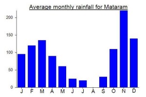
Local Average Monthly Rainfall (mm):
Location
Click on the blue arrow ![]() (top right) to see your current location on the map
(top right) to see your current location on the map
https://en.tempo.co/read/2039304/forestry-ministry-updates-mount-rinjani-hiking-rules
Climbed Rinjani this last week and had an amazing experience. Fantastic weather and really beautiful scenery (as long as you do not look down at the trash and garbage which is left behind by everyone!). Opted for the 3D/2N hike from Sembalun and exited via Torean. Taking the extra time really meant I was able to enjoy the mountain more and not feel under time pressure to reach the summit and then get out which has happened on some other volcanoes, nice to sit back and take it all in.
As a strong hiker, these are my timings to help others plan:
Day 1 – Sembalun Trailhead to Rim Camp – 6 hours
Day 2 – Camp to Summit was 3 hours and back to Rim Camp was 1h15. After relaxing breakfast descend to Lake Cake and reach by midday. Time for hot springs and explore the lake
Day 3 – Lake Camp to Torean was 6 hours – this route was a lot quieter and not much trash with amazing scenery so would strongly recommend this option
Happy bagging but need to recognise this is a very popular mountain and littering i
Really enjoyed the experience on this hike. I opted for a 3 day, 2 nights trek, with an exit via Torean and did not regret it. The torean exit makes day 2 a bit longer but also provides a big change of scenery and a lot less people during day 3 where I went through some magnificent lush green landscape and sulfur rivers.
No group tours go that route so you will have to go on your own or hire private. I can recommend the guide I used, Suboh (+62 877-0440-5757) who knows the mountain well and speaks good English. Working with a guide directly you can avoid the organiser fee and end up with a better deal for you (and the guide / porter team too).
Happy bagging!
Mount rinjani has other name (Ancient Name). Many literatures called it samalas. Mount samalas has summit height almost 5.000 meters about sea level(based on scientist prediction).
Amazing website, Well done Please check out Rinjani Trekking
Bali, September 14 2020
A very unfortunate adventure
To Whom It May Concern:
We previously climbed Gunung Rinjani several times. After reading in the Jakarta Post that Gunung Rinjani is once again open for hikers we immediately booked our entry passes for Gunung Rinjani.( September 8 and 9) This was done by Klaus which is very experienced with electronics. However the App required cannot be down loaded on I Phones and works only on Android, and as such caused a lot of difficulties.
As be both are long time residence in Indonesia (30 Years) and Kitap holders Klaus booked under Indonesians. With our connections we organised our own experienced porters. Please do note that we hike volcanoes across Indonesia and as such always bring our own equipment, tents, food, etc.
When we arrived in Sembulan we checked into the Nusantara hotel ( 1 pm) right next to the Rinjani registration office. After check in we trayed to register for our next days hiking. Unfortunately the Park office was not occupied until around 5 pm.
When the officer finally arrived he looked at our white skin and immediately mentioned that our booking is not valued and that we have to book as regular foreign tourists. He was not at the slightest interested that we both are KTP holders and long-time residence in Indonesia paying taxes and employing well over 130 Indonesians.
He repeatedly mentioned that our skin is white and that we are foreigners and as such we can only book through a trekking Organiser. He then called a trekking organiser which arrived after 10 minutes. The TO immediately mentioned that he is very expensive and that he charges US$350 per person for the 2 day 1 night trip. As fare as we know it is illegal to charge in Indonesia in US$????
The Taman National Officer then also mentioned that we would need a health certificate which of course we could only get the following morning.
The officer showed absolute no interest to assist us in any way. He was only interested to make our lives as difficult as possible.
He used on us several times the words white skin and BULE in a very negative way which is not very nice and seriously disrespectful towards guests.
To our great disappointment we then decided to cancel our Rinjani hiking adventure and spend our money elsewhere.
We also found out that we where the first (BULES, WHITE SKIN) that attempted to hike Rinjani since the re-opening. Talking to several porters we also found out that through Cofid 19 the hiking income was virtually zero. We would have easily spend RP.1’000’000 per porter and given them and their families a little well needed income.
It makes us very sad to know that The Rinjani region offers such beautiful vistas and that obviously officials are not interested to assist visitors. We guess they do not need to as their income does not depend on visitors, unlike farmers, porters and their families.
Your sincerely
Heinz von Holzen
Klaus Ullrich
Bali, 14 September 2020
Petualangan yang sangat disayangkan
Mohon Perhatian:
Kami sebelumnya sudah mendaki Gunung Rinjani beberapa kali. Setelah membaca di Jakarta Post bahwa Gunung Rinjani sekali lagi dibuka untuk pendaki, kami langsung memesan tiket masuk ke Gunung Rinjani. (8 dan 9 September) Hal ini dilakukan oleh Bapak Klaus yang sangat berpengalaman dengan elektronik. Sekalipun aplikasi yang diperlukan tidak dapat diunduh di IPhones dan hanya berfungsi di Android, dan karena itu menyebabkan banyak kesulitan.
Kami berdua telah tinggal lama di Indonesia (30 Tahun) dan Bapak Klaus pemegang Kitap orang Indonesia. Dengan koneksi kami, kami mengatur sendiri jadwal perjalanan kami. Harap diketahi bahwa kami mendaki gunung berapi di seluruh Indonesia dan karena itu kami selalu membawa peralatan, tenda, makanan, dll sendiri.
Sesampainya di Sembulan kami check in ke hotel Nusantara (jam 1 siang) tepat di sebelah kantor registrasi ke Rinjani. Setelah check-in, kami bersiap untuk mendaftar hiking hari berikutnya. Sayangnya tidak ada orang di kantor registrasi sampai sekitar jam 5 sore.
Ketika petugas akhirnya tiba, dia melihat kami berkulit putih dan segera menyebutkan bahwa pemesanan kami tidak bisa diterima dan kami harus memesan sebagai turis asing biasa. Dia sama sekali tidak menghargai kami bahwa kami adalah pemegang KTP yang sudah lama tinggal di Indonesia dimana kami membayar pajak dan mempekerjakan lebih dari 130 orang Indonesia.
Dia berulang kali menyebutkan bahwa kulit kami putih dan kami orang asing dan karena itu kami hanya dapat memesan melalui Penyelenggara trekking. Dia kemudian menelepon penyelenggara trekking yang tiba setelah 10 menit. Penyelenggara trekking segera menyebutkan bahwa harganya sangat mahal dan dia mengenakan biaya US $ 350 per orang untuk perjalanan 2 hari 1 malam. Seperti yang kita tahu pengenaan tarifnya US$ adalah ilegal di Indonesia????
Petugas Taman Nasional kemudian juga menyebutkan bahwa kami memerlukan surat keterangan sehat yang tentunya hanya bisa kami dapatkan keesokan harinya.
Petugas sama sekali tidak menunjukkan minat untuk membantu kami dengan cara apa pun. Mereka hanya tertarik untuk mempersulit kami sebisa mungkin.
Dia beberapa kali mengucapkan kata kulit putih dan BULE dengan cara yang sangat negatif yang tidak terlalu baik dan sangat tidak sopan terhadap tamu.
Dengan kekecewaan besar kami, kami kemudian memutuskan untuk membatalkan petualangan hiking Rinjani kami dan menghabiskan uang kami di tempat lain.
Kami juga mengetahui bahwa kami adalah orang pertama (BULE, KULIT PUTIH) yang mencoba mendaki Rinjani sejak pembukaan kembali. Berbicara dengan beberapa pemandu pendakian, kami mengetahui bahwa karena Covid 19 pendapatan pendakian hampir nol. Padahal kami akan dengan mudah membelanjakan RP. 1.000.000 per pemandu, yang berarti mereka dan keluarga mereka bisa mendapat sedikit penghasilan yang mereka butuhkan.
Sedih rasanya mengetahui bahwa kawasan Rinjani menawarkan pemandangan yang begitu indah dan dimana para pejabat tidak berminat untuk membantu pengunjung. Menurut kami, mungkin mereka tidak perlu penghasilan dari pendaki seperti kami, karena pendapatan mereka tidak tergantung pada pengunjung, tidak seperti petani, kuli angkut dan keluarga mereka.
Salam,
Heinz von Holzen
Klaus Ullrich
I had a similar awful experience when attempting to hike Rinjani. It seems that the locals can be quite racist, and upon seeing a European face, they immediately think about how much money they can extract from you. While I was there, I overheard a few racial slurs in the Lombok language, which I happen to understand a bit. They don’t seem to care whether you’re an experienced hiker or not, or whether you truly require a porter or guide. On top of charging ten times more for a ticket to enter the park, they’ll also require a mandatory porter and guide, which can make your trip cost literally 100 times more than what a local person would pay. In my country, if anyone tried to charge a person 100 times more based solely on their skin color and disregarding their residency permit, that person would already be punished by law, and their business would have been shut down.
My advice would be to avoid hiking Rinjani to avoid supporting the local racists there.
It can be disappointing sometimes in Indonesia when you are treated based solely on your appearance. Is it racism or just a very simple way of thinking? I’m not sure. The only way to tell for sure would be to see the reaction if you were to have an Indonesian passport. How would a white Indonesian be treated? It is definitely discrimination and this discrimination is somewhat ingrained in the society, for better or worse as some foreigners do benefit from all the assumptions made about them. Many local people make these assumptions about foreigners based on very little real evidence aside from Hollywood films and the like. I don’t mind paying a bit more (say double price as is usually the case in Malaysia) but when it becomes 10x or even 30x as in some National Parks then it does feel like you as a person are not especially welcome, but your wallet is welcome. I cannot see this mindset changing for a long time – maybe generations. The education system leaves a lot to be desired.
Hello, may I ask who enforces the rule of mandatory guide? Im planning to climb to the crater rim without a guide or porter and some people have said it is possible.
Planning to hike Rinjani mid April 2020, do you know if the summit is open again after 2018’s earthquake… would be keen to bag the summit.
The headline here is enough! “Mount Rinjani to have cable car”. What a terrible shame. The authorities both here and in other countries such as Vietnam (for Fansipan mountain) are more interested in money than preserving what they have and understanding that mountain areas are beautiful because of the LACK of impact of technology and humankind all over them. They are beautiful because they are difficult to access. If this project goes ahead then the experience of being on the Rinjani rim and summit will be completely tamed. No longer a transcendental experience, but a commercial one, with even these high reaches of mountainside tainted by our species. An extension of the urban areas below. I am glad to have climbed it before this was proposed! Dear oh dear!
https://en.tempo.co/read/1302239/mount-rinjani-to-have-cable-car
A news story on Gunung Rinjani from today’s Jakarta Post which illustrates more than anything why a better education system is sorely required in many parts of Indonesia. Critical thinking is in such short supply.
“The Mount Rinjani National Park Agency (TNGR) plans to have separate camping areas for male and female hikers in a bid to support halal tourism in Lombok, West Nusa Tenggara (NTB).”
“Sudiyono said the idea had come from the people living around Rinjani who believed that last year’s earthquakes were caused by the disrespectful activities of hikers.”
High time the locals living around Rinjani learnt a thing or two about geology, history, tectonics, litter management and recycling, tolerance…. and perhaps took a critical thinking class or two. I wonder what evidence they uncovered in support of their ‘belief’ that last year’s earthquake was caused by ‘disrespectful activities of hikers’. This would be a hilarious story were it not indicative of a global problem of pandering to the utterly uninformed under the guise of democracy.
Hopefully this rule will not come to pass and the local government will take steps to improve whatever education the local people are currently receiving. What a sorry state of affairs.
https://www.thejakartapost.com/travel/2019/06/19/mt-rinjani-park-to-separate-male-female-hikers-in-support-of-halal-tourism.html
Thankfully this ludicrous plan has been cancelled after widespread ridicule!
https://en.tempo.co/read/1216528/lombok-scraps-plan-on-hikers-separation-in-mount-rinjani
yes couldnt agree more that a way better education is needed. so that they can be more clever and NATIONALISTIC, not easily say “yes” to other people argument, not to mention always remember that discussion is still important. stop making them looks stupid with their own beliefs! just fyi, i dont believe in what they believe about the eq (neither a moslem), but if it’s theirs, i try to tolerance it and let the concept of democracy itself does the job. also just fyi, indonesia is a religous country. if you have no tolerance about it to be happening here, then you know this country doesnt even need you. we are nice if u are the same. xx
Hi,
A detailed description on how to climb Mount Rinjani can be read on my post : http://www.yonderingsoles.com/2015/06/01/gunung-rinjani/
It also provides the elevation and distance for each day, with some pictures!
Rinjani crater via south route (Timbanuh/Tetabatu):
Just got back from Lombok and a 3d/2n mission on Rinjani. We opted for the south route, starting at the park gate in Timbanuh (elevation 825m). We decided on the south route to escape the hordes of noodle-eating teenagers and infamous garbage strewn trails and campsites of the classic northern routes. True to rumour, we literally saw no other humans in our 3 days. We camped on the crater rim at about 2800 m and had Rinjani to ourselves. Fantastic views. So if you are looking to escape the crowds and garbage, the south route is for you. The catch however, and it’s a big catch, is that the south route does not lead to the summit in any direct way. So if you are a purist, and must get to the top, this is probably not an option for you. However, if camping on and climbing up the rim to about 3400 m works for you, this is a great option. No people, no garbage. And the usual spectacular views of the crater, and of course, Rinjani peak. We used Jaya Trekker (www.jayatrekker.com), who are based in Tetabatu. All in all, they were adequate and friendly, but no frills. Prices might be high (as on their website – but I have nothing to compare it to)? They picked us up at the airport, we spent the night in Tetabatu (which in itself it quite nice!), and then started the climb the next day. Upon return to their base, they drove us to our next destination (fastboat to Gilis), which was great. The crew (1 guide, 2 porters) was relatively competent, and all went according to plan. Food is very basic Indonesian, no frills. Again, might want to haggle on price, as prices seem very steep for what you get (but that could be everywhere).
Really great to find this post. And thankful to admin who take lots of his productive time writing this resourceful information. Wish Rinjani will be a bucket list of majority climbers.
Dear all,
From fellow travellers I heard that it is possible to climb Rinjani without a guide. Since me and my friends are rather short on cash we’re thinking of doing the track just by ourselves.
But my question here, are we actually allowed to do this on our own?
And is it possible to rent a tent and cooking equipment in either Senaru or Sembalun?
Kind regards,
Tim
Haii Mount Rinjani Trekker.
Everybody know how wonderful of mount rinjani even you just see from the internet or you went there for vacation. Will you join the local comunty of Sembalun People to keep the beauty of the mountain..?
Yes, honestly we aware that, we are as the local people who bring just few pisses of thrash up to the mountain feel mad to the visitor who bring a lot of plastic up to the mountain and just leave it up there and then we are the closet from the mountain trek up to clean the shit of the Bad Trekkers who leave their shit wherever they want. From the oldest generation to the youngest generation of the local people still believe that MOUNT RINJANI is a Holy mountain. So please help us to keep the beauty of Holy Mount Rinjani by invite the world trekker lover to take care of the clean and the beauty of the mountain.
You may join the SCDC Sembalun Community Development Center to share your idea for the Trash Management on Mont Rinjani or Lombok Island in General.
Rinjani Says > Take only the photograph, and leave only your foot print.
Thanks
Dear Mount Rinjani Trekking,
I hiked up Gunung Rinjani in 2009. I was disgusted at the trash and human shit left by the local people on the mountain. Local people eat those small candies and throw the wrappers on the trail and in the lake. Local people camp beside the lake and fish in it. They leave fish bones and bodies all over the ground. They make fires and leave the pit unclean. They are the ones who shit everwhere on every path. I wanted to camp beside the lake, but could not find any place that was clean.
Stop blaming the tourists. It is your own people who are throwing old metal and plastic in the lake and on the ground. The foreigners who want to climb a mountain, are there for the beauty, not to make a mess.
Almost every foreigner has a local guide. If you want to blame somebody, then start with the local people and then with the guides. You collect money from foreigners – why? Use some of that money for cleaning the mess. Tell all guides to carry an empty garbage bag up the mountain, and fill it when they come down. I know the Western foreigners will help with this.
Good luck getting local people to do the right thing….
Keith
Not more Than Trekking but more of spiritualitas to do hike to rinjani
Dear Gunung Baggers,
I am currently trying to make sense of something I heard about the southern route from Tetebatu/Aik Berik.
I know that the climb is more challenging as you start much lower than Sembalun or Senaru, and you need to trek through the jungle. Also you end up at Segare Anak with no path leading to the summit except for crossing the lake by boat or raft.
However I was told by agencies in Senggigi that the ascend was considered dangerous and not safe. They told me that a guide has died on this route (found a report here http://regional.kompas.com/read/2014/08/26/21355521/Lewat.Jalur.Alternatif.Guide.Pendaki.Tewas.di.Gunung.Rinjani.)and recommended to avoid it. With lots of competition among trekking companies there, I would not be surprised if this was just a story to have me sign up with their own trek from Senaru.
Shortly after, I asked people in Tetebatu about it and they (of course) denied and said it was safe and all.
In the article I linked to above, it is also recommended to take the northern routes because in case of an emergency a rescue team can reach and safe you a lot faster than on the southern ascent.
Tried to climb Rinjani in one day together with my wife. That’s definetly possible, but due to too strong winds turned back at 3500-3600 altitute.
Some details:
Getting there in a cheap way:
Spent a night in Mataram. 8am left from Mataram Bartais station with a local bemo for Aikmel (price 20000 rp per person), takes about two hours. I was told there are no bemos from Aikmel to Sembalun, so we took a “public” pickup truck for 25000 rp each. Had to wait sometime for people to fill up. Took about 1 hour and at 1pm we were in Sembalun.
Accommodation:
There are alot of homestays in Sembalun near Rinjani Visitors center. We stayed in one for 150000rp per person, cold water. The one we stayed also had mini restoran with quite good food and big portions (I dont remember the name of Homestay, but if you go from Rinjani visitors center to Lembah Rinjani villa, the homestay would be the 1st one on the right side of the road). On our way back they called for a pickup truck to get us to Aikmel. Happy with my stay there overall.
Permits:
We went to Rinjani visitors centre and asked tickets for a day hike without mentioning that we’ll try to reach the summit. We were not even offered to buy guides or porters.
Hike itself is about 35km and 2800 ascending meters to the summit.
To reach 1800m altitude (posIII ?) is really easy, took 3 hours and it’s like 10km distance. Most of the distance is just simple walk in the fields.
From 1800m to 2700m (last camping groud) is easy to ascend, took 2 hours.
Most diffucult part to from 2700m to the summit. The big portion of the trail is very loose ground.
We turned back because close to the summit winds got really strong, it was difficult to stand on our foots and once we were on four limbs we were bombed by small rocks and sand.
To reach 3500-3600m it took us 2,5 hours, but I’m sure in a good weather 2,5 hour would be enough to reach summit from 2700m. Locals told that it’s not that windy usually. But it was sunshine, so not that bad, still got good views all the way up.
The descend is opposite than ascend. Getting back to 2700m camping ground is easy and quick. Getting back to 1800m took more time than to ascend (2,5hours vs 2 hours up). From 1800m back to town is easy again, except fatique.
Overall it was a nice experiance, 15 hour hike, 3.5l drinks per person (3l water + 0,5l soft drink), lots of stanks. We started at 12am, looking back I think that 11am or 10am might be better, wind was not that strong earlier in the morning.
One thing to mention is that 4 days ago we did Agung hike in Bali, so that helped alot to deal with altitude, which we almost did not felt.
I believe there are some advantages if you have money to spend for hire the local terkking organizer there. Beside porters that can carry your luggages (and they do have eperience to carry those to the summit) you can also have a guide who can help you manage the time, accomodation, and assist you on handling the nature of Mount Rinjani.
But I am glad you enjoy with the experience on Mount Rinjani and I am from AdiTrekker.com on behalf of Mount Rinjani trekking organizers looking forward for you come again and feel excitement with us.
Do you remember how much they charged you for that day hike? Thanks
Mt.Rinjani, Lombok, West Nusa Tenggara, Indonesia is indeed one of Indonesia tropical mountains which has the most beautiful scenery that my last visited on October 2014.
Thanks so much to Hafid and Fadel ( porters ) who helped our team in the trip.
Regards,
ONY TJAHJONO
Doha, State of Qatar
Hi, I am traveling in Indonesia and hoping to do a 2 day/1 night trek to Rinjani sometime during August 29th through September 3rd (2014). If anyone is interested in sharing the cost of a guide or package let me know.
Thanks,
Astara
aligh001@ucr.edu
Hi Astara. You can contact us http://www.lombokservice.com via email admin@lombokservice.com. We can offer you a good package and excellent guide/porter. I’ve climbed Rinjani twice and guarantee it’s worth it! Loren
Saya berharap anda bisa menyampaikan sesuatu tentang ini. Kesadaran para pendaki saya rasa masih kurang dalam menjaga alam.
https://www.facebook.com/media/set/?set=a.10151132094199034.459008.155191554033&type=3
Hello explorers,
We just came back from rinjani trek during Hari Raya. We trekked from Sembalun to Summit to Semaru. It was an awesome trip. I have uploaded my GPS map along with some pics taken on trip.
http://ghostpipe.blogspot.sg/2014/08/gunung-rinjani-trek-in-cloud.html
Would like to mention also that we trekked with Green Rinjani (Airee). First thing, he forgot to pick us up at airport (never apologized). We shared the guide and porter with an Australian couple who were very accommodating.
Though there was glimpse of his good service, as others have mentioned. Probably low manpower and high demand during Hari Raya might be the reason. Thanks anyway, we had awesome time.
Hey trekkers
Let’s explore the world wider with taking tour to learn the Sasak Cultre and Tradition.
We are the Rinjani Explore Base in Sembalun Village(Rinjani Starting Point), Easy to find us.
we invit you to taste the real adventures and find your Happiness in Nature with takking a Mt.Rinjani Trekking, Pergasingan Hill Soft trekking, Sembalun Village Tour (Agro Tour)and Sembalun Camping Ground..
We provided you many alternatives trek and as the excesise for you before you do your trekking to Mt. Rinjani.
To get more info just take your litle free time to check what we provide here http://www.rinjanitrek-lombok.com or http://www.rinjanisttlombok.com.
yyy,,,Macooo… Polooooo…
Thanks
By
MRE
The trek from Strawberry fields, Bawak Nao, is a shortcut. The official trek is right next to the registration office, around 3 km longer than the strawberry fields trek. However, the official trek is a hundred meters higher but there’s some intersections which may lead you astray because there are no signboards.
It is strongly, strongly advised not to leave your stuff, on the way for the summit party, in your tent unattended! Some “monkey thieves” at Sembalun Lawang are smart enough to unlock padlocks on your tent zipper. Some of these elusive “monkeys” are not so friendly to low budget trekkers who don’t use the services of either porters or guides. Pay someone up there to attend your stuff! Rinjani offers almost everything any Indonesia volcanoes trekkers can get. But, there’s another side to it, too.
Gudluck and have a safe journey.
Climbed this in Jun 2014. Challenging but a rewarding trip:
https://www.flickr.com/photos/vinchel/sets/72157644885356897/
What excellent photos Vinchel! I saw the same sights and had very similar photos (but yours were much more professional). Your photos brought back great memories of my hike five years ago – now I’m sure I have to find a way to go back! Cheers, Keith
Hi, I see I need a health certificate to climb Rinjani, can I get it from a Puskesmas in Lombok? And does anyone know where is it? And how long does it take to get a check. Thanks
Hi Plops
I climbed last June…. no certificate needed then.
Sean
Thanks Sean!!does anyone know if they have changed the Entrance fee charge? I heard they have changed it to a per day charge!!!! Rp 150k per day for foreigners
BOOKING RINJANI TREKKING
Green rinjani trekking
http://www.greenrinjani.com
http://www.greenrinjanitrekking.com
Email: info.greenrinjani@gmail.com
Green Rinjani Trekking Information
Green Rinjani Lombok, trekking trip and planting a tree on the mount Rinjani with eco friendly solutions for tomorrow’s environment.
Plant a tree on your trek to Mount Rinjani
While trekkers become more and more concerned with environmental issues, we have decided to offer you an eco-friendly trek, in order to bring a positive impact on our beautiful volcano. The objective is not only to reach the summit, but also to offset the carbon emissions due to you plane travel and to leave a positive impact on the mountain by planting a tree at the beginning of the trek. Each year, more than 3000 international trekkers tackle Rinjani’s slopes. If all of them would take a few minutes to plant a tree on the way to the caldera, within a few decades, this could make a big difference.
Why should you plant a tree on Rinjani?
Tropical forests are home to most of the world’s biological diversity. It is important to maintain this huge biological reservoir. Moreover, a significant portion of global greenhouse gas emissions comes from deforestation and forest degradation. Reducing the deforestation rate is crucial to slow down global warming.
Deforestation is a big issue in Indonesia, and Lombok is also being affected by the reduction in forest cover.
Land conversions of forest to agriculture along with population growth and cities expansions have considerably reduced the forest areas. Water springs respond to those changing and as more water is being demanded, and the forest areas decrease, evidence shows that many springs have disappeared, leading to a situation of water scarcity.
What will you have to do?
Just join us our program to climb Rinjani’s volcano. The itinerary is the same; the price of the trek remains unchanged; we just take some time between Senaru and base camp I to plant a tree. This area has suffered from deforestation over the past few decades, but the climate is very favorable to vegetation growth. Our guides go to Rinjani every day, and will keep looking after your trees along the year.
GET CONNECTED WITH NATURE, Plant a tree for the future
MOTIVATION
It’s not just about YOU
It’s about the
generations to come!
Don’t wait . . !
Plant a Tree Today!
An easy eco friendly solution for our environment!
If everyone planted a tree…
Together, we’d make a BIG impact
Have nice days ………..
See you in Lombok Island
Best regards
Ariee
Hi all
I’m Ariee from lombok i’m the owner of Green Rinjani Trekking Company.
Rinjani mountain will be closed 10 january-1april
If you like to doing a trek you can book directly to me bay sent me email info.greenrinjani@gmail.com mobile +6281916030327
Thank you
Happy new years TEREKKERS
Best regards
Mr ariee
Hei Trekers…
Rinjani willl close for 3 moonths becasue will be dangerouse to do the trek in Raining seasson..
So during the rain seasson here, prepare you self to do the trek for nex year.
Rinjani will open at the first of April.
Join me on Facebook.
Muji’s Cdcoldermember
Last weekend started with the inevitable Lionair delay. Those who only travel with Lionair during weekends would be forgiven for thinking that no Lionair craft has ever departed on time. Thankfully it didn’t turn into the horrific 6 hour delay experienced just a few weeks ago and we were in Lombok around about midnight.Friendly old taxi driver took me down to Kuta, about 25km away from the new airport, for Rp10,000 airport charge plus about Rp70,000 meter (30 minutes ish). Clearly Kuta is going to look very different ten years from now.
The driver from Green Rinjani was already waiting at the front of my hotel, ready for a 5am departure to Sembalun. I had 3 hours sleep before meeting a co-hiker and heading off for the mountain itself. We stopped for breakfast in Senaru (after about 3 and a half hours), were introduced to a third hiker who would be joining plus our local guide. Remarkably, for the start of November, we were to encounter no rain whatsoever over the following 3 days – just lovely, sunny weather.
Sembalun is about an hour away from Senaru by car. Quite why the national park thought to build their Sembalun visitor centre (where you must register when starting hikes from this side) several kilometres beyond the starting point is just another typical example of the downright lack of logical thought encountered in Indonesia. If you’re in a good mood it’s comical and if you’re in a bad mood it’s just yet another needless irritation to add to the week’s already extensive collection. Either way, doesn’t take much common sense to work out that registering at or on the way to the starting point would save drivers and hikers an extra 30 minutes of travelling time before commencing the actual hike itself. Most information you will get beforehand suggests that the Sembalun starting point is at a height of 1,130m. This must refer to the visitor centre because a GPS will give a reading of a shade under 1000m at the real starting point.
Not far from the starting point is a vast area covered in low-lying metallic structures, apparently a strawberry and watermelon nursery that went bankrupt some years ago. A large number of sleepy cattle roam the savannah area, all with bells tied round their necks creating a lovely ‘cow gamelan’ orchestra sound as you walk by. The various bridges crossed suggest a fair bit of money pumped in to this Suharto-era project to build a road up to the lake. The carp in the lake were introduced by Suharto. Was he thinking his family could turn the whole area into some kind of profitable ranch? Thankfully the hungry hiker can benefit from the substantial fish population up there. Back to the ‘road’ itself, our guide suggested that there was a more sinister purpose to this road too – a place for the ‘elimination’ of those who held views contrary to the government. Who knows.
The following morning, along with about a hundred others, we made our way with torches up to the summit ridge. It was very blustery, and most guides suggested to their groups that it would be dangerous to continue to the peak. I decided to wait for over an hour until there was a bit of light in the sky to the east. Heading on alone I met a couple of hikers who had turned back due to the wind and also no doubt due to exhaustion – the last section requires a great deal of patience. In the end 6 hikers made it to the summit that morning, and amazingly I had the top to myself as the other 5 had already begun their descent back to camp for breakfast. Back in 2009 I had been prevented from getting to the top because of volcanic activity down below at Gunung Baru/Barujari so it has been near the top of my list for over 4 years! Delighted to have finally made it up there.
We were down at the lake by lunchtime. When doing the 3 days / 2 nights Sembalun to Senaru traverse, you have a choice where you camp the second night – down at the lake (usually quieter) or up at the Senaru rim (busier and an extra 2 and a half hours of ascent on Day 2). We opted for the lake after having heard that the hot springs were cleaner than in previous years. It turned out that they were cleaner – and what a perfect temperature! However the park authorities really do need to put in some kind of toilet facility down there. Being halfway along the hike it makes perfect sense. At present there is still far too much litter too, the vast majority left by Indonesian hikers (who pay significantly less for their entrance ticket!) If local hikers can’t keep the environment clean, at least the park authorities could send a team out once a week to collect the rubbish. It wouldn’t cost a great deal given how much the authorities rake in, but it is alleged that most of the cash goes straight to the national parks office in Jakarta.
For our second night on Rinjani we drank a couple of beers and some brem (local rice wine) and heard fascinating stories from our guide of how, in the event of a motorcycle crash, and even when involving fractured or broken limbs, his community shuns hospital treatment in favour of magical massage oil. The local Sasak music he played us on his phone sounded most peculiar – a flute played vertically in the snakcharmer fashion. Quite a few local Sasaks were out fishing round the lake – a bit of a problem when you want to find somewhere secluded to ‘visit the bathroom’. From what we could gather, a lot of these fishermen barely had a grasp of Indonesian language. Another advantage down at the lake is that it is not too chilly at night. In actual fact, I only felt cold on the summit ridge before light – the tent and sleeping bags provided kept us very warm indeed.
The following morning’s hike up to the Senaru rim was utterly beautiful in the sunshine. Perhaps one of the finest sections of trail in Asia – what incredible views. One member of a large local party had fallen several metres and injured himself the previous day, and porters were working hard carrying him up the many steep sections here. Up at the rim campsite we were treated to more spectacular views of the peak, the lake, and all the litter that had been left by careless hikers! From here it’s down all the way – over 2000m down – to Senaru. A lot of the signs have incorrect elevation data on them, but I wonder how accurate the information given on one sign is, which states there are no less than 85 water sources or springs within the national park area. Probably true – would be great to see a map of them all (could also be very useful in an emergency).
I would definitely recommend Green Rinjani – the price (Rp2.1 juta per person for our small group of just 2 or 3) was one of the less expensive ones but we got extra stuff like a few cans of beer and brem which was a nice touch! I had previously contacted Mr John, whose company has been doing Rinjani treks for decades and is obviously making a fortune out of it given his vehicles, but he seemed very unaccommodating when it came to being able to pick us up early from Kuta on Day 1. We would not be ‘on schedule’ or so he thought. I have also heard that certain companies are very inflexible when it comes to the requests made by guides/porters, even just for a certain brand of cigarette. A breakdown of the price would, alas, probably reveal that those who do the most work get paid the least! Only thing Green Rinjani could do better would be to have a more complete idea of what vegetarians might like to eat rather than just providing standard meals ‘minus the chicken’ or whatever.
On the way back down to Kuta we saw more evidence to suggest that certain areas of Lombok are the dirtiest (in terms of litter) in Indonesia. One sports field in particular was so covered in rubbish that it was hard to see the grass! No civic pride at all? Down at Kuta I stayed at the new Bombora bungalows excellently located between the beach and the centre of town. The authorities have just knocked down the beachfront warungs – let’s hope the beach is left to be a beach rather than exploited for further commercial purposes. Make sure you ask locals about the legend of Putri Mandalika and the worms!
mystery of another global “year without summer” solved: in 1257 it was Rinjani, when it’s huge caldera was formed: http://www.pnas.org/content/early/2013/09/26/1307520110
Yeah, I read about it on the BBC.
http://www.bbc.co.uk/news/science-environment-24332239
Bizarrely the BBC article doesn’t include the word ‘Rinjani’!
I climbed Rinjani in July and it was a fantastic experience. Perhaps I should have started on something smaller, but I did, eventually, make the summit:)
Interesting point about the rubbish. On the way up, I was appalled at the amount of plastic on the mountain and observed many local hikers just dropping rubbish and walking on. On the way down, it was as if the ‘Crap Fairies’ had come and cleaned everything up. I asked Mr John from John’s adventure tours and he said that the villagers around the area (Senaru, Sembalun Lawang) sent 15 people three times per month to do a clean up. HE claims to have footed the bill for this, but hey, who knows? Regardless, the situation on the way down was a lot more pleasant than on the way up.
Did anyone talk about the monkeys? They are everywhere especially at Plawangan Sembalun, the peak, the lake and Plawangan Senaru. Offcourse also at the hotspring by the lake. They steal food so be careful and make sure someone watch you stuffs.
There are also wild dogs that look like domestic dogs. People say they were domestic dogs who somehow ran away and live in the mountain.
The talk about the money going to Jakarta could be true but local governments are normally not better in managing assets, let alone “difficult” ones like G Rinjani. So privatization with the help of international or national expert should be the best.
sorry the phone numbers is wrong.
phone -> +6287-763-763-529
thanks somuch
Won’t have enough to thumb this up :), I’ve been there last september, and still dreams to one day will spend a whole week just sit and watch the sun goes down at plawangan senaru or at Segara Anak. Never get enough though.
I did this trek last weekend, 3 days 2 nights from Sembalun to Senaru (which I’d definitely say is the best way to go) and did about a month training before the climb. Training involved walking at a good pace on the steepest possible incline for a couple of hours, 3 nights a week and I can tell you it paid off!
This climb was super amazing, a real challenge especially on day 2 when we were woken up at 2am (I actually couldn’t sleep more than 20 minutes that night as the porters were snoring!) to do the summit (3 hours) and back down (2 hours), followed by a very steep 700m down to the lake (3 hours), followed by another 2 hours steep up to the second campsite – I forget the name…
The hot springs were a godsend… It really soothed our aching legs and feet.
Now, one thing I have to mention is the state of this trail… The rubbish and the human feces everywhere was just terrible. The campsite by the lake was in the worst state and I was so glad we didn’t have to spend a night there. We had a long chat with our tour agent, John, and he said every month the national park takes over 100 million rupiah from trekkers’ fees, most of which gets sent to Jakarta for god knows what and hardly any is left to pay for clearing up the campsites.
At the end of this year, the tour agents are all planning to demonstrate and their aim is to privatise the national park and provide some toilets, rubbish bins and proper rubbish collection etc.
I wish them the best of luck as if something doesn’t change soon, this beautiful mountain is going to be ruined. Everyone we met complained about the state of it…
Other than that the views were amazing and the climb a real accomplishment.
We climbed Rinjani 2 years in a row. 4D 3N each time. The first year (2009)we started from Senaru. By the time we arrived at the summit base camp (Sembalun side), we had no stores of energy to go to the summit the next morning. So we missed out on reaching the summit. The next year we went back and climbed from Sembalun to Senaru. Because we reached the summit base the first day, we had heaps of energy to climb to the summit the next morning! I would highly recommend climbing Rinjani this way. Prior to climbing Rinjani I had never climbed anything of note. Now I’m addicted to this ‘hobby’ and am tempted to go back and do Rinjani yet again! Last time we took 6 friends with us and introduced them to the beloved mountain. We helped each other through the tough times and 5 of us reached the summit. Not a bad effort! I highly recommend this trek. However, it’s very dangerous and you really need to pay full attention most of the time and please be careful! Enjoy 🙂
The best Mountain I ever climb, got a beautiful lake, relaxing hot spring, and a very friendly locals. although its a shame that some places filled with litter. the water source in Plawangan Sembalun are better than any other fresh water i ever drank… i’ll be back soon Anjani…
please check out my article on Rinjani in this month’s hellobali
http://www.hellobalimagazine.com/index.php?option=com_content&view=article&id=333%3Aon-top-of-the-world&catid=170%3Alombok&Itemid=101&sms_ss=facebook&at_xt=4de99bff5ca3b4d4%2C0
A very worthwhile post on the Lonely Planet forum – a good way to avoid the rip-off system currently in place in Lombok whereby the guides get paid very little and a few fat cats make a fortune!
http://www.lonelyplanet.com/thorntree/thread.jspa?threadID=2062700
Mt. Rinjani – excellent mountain guide +6287864055205
We had a great time climbing mount Rinjani last week (8-10 May 2011). The hike took us 3D2N starting from Sembalun Lawang and ending in Senaru. The views are really unforgettable! It is so worth the strenuous climb!
To save costs and make our trip more adventurous, we decided not to go with the standard US$200 package as offered by various companies. Instead we brought our own gear and simply called Lombok Taksi to pick us up at 5am in our hotel in Mataram. They go by metered fare. Mataram-Sembalun Lawang is about 270,000Rp (2.5hours) and Senaru-Mataram was around 240.000Rp(2hours). Upon arrival at the Rinjani Information Centre in Sembalun, the NP ranger helped us to call up our mountain guide who appeared 20 minutes later. We also decided to take one porter to carry up water and our tent (which we had brough ourselves). Once agreed on the prices (125,000/day for the guide), and 100,000/day for the porter + 40,000/day for food per person), we started our journey up the mountain. It is that easy. Our mountain guide Mujiano turned out to be really good: an ideal balance between giving us peace and answering our questions when needed (He was very knowledgeable about the mountain as he grew up in Sembalun and his grandfather, who was the village head, told him everything there is to know about the mountain. He also had done 1 year of tourism school, speaks English very well, and is very alert to accomodate for his guests’ needs)
We hadn’t made any prior arrangements, which was fine since May is low season. Yet, next time we surely will call Mujiano in advance. I recommend you do the same.
Mujiano hp +6287864055205, email address muji_rinjani@yahoo.com (as he lives in a village w/o internet and cannot afford 3G he can only check his email about once a month: hence better call him directly 🙂
dear all
i’m muji from sembalun.
thanks a lot bother to put my name on.
i’m so sorry for this new info,all is diferen now..
not like last year.
the price is diferen.
note : my phone loosed and the number.
mror info:
conntact :
phone -> +628-763-069-529
e-mail -> mujirinjani@yahoo.com
muji.lomboktime@gmail.com
facebook-> mujis’s cdcoldermem
best regard
muji
sorry i forget one number of my phone.
phone -> +6287-763069529
nice to waiting for your call.
best regard
muji
Muji is a great guide, very organized, responsible and helpful.. i highly recommend.
Hi Dan,
I was wondering if you have any rental recommendations (sleeping bags, tent, stove & utensils) at Sembalun?
Much much thanks before
Hi Kieth. I hiked the same route (Sembalun to Senaru) about a month before you in 2009 and I agree with your assessment of the campsite around the lake. The lake water looked OK for swimming when I was there, but the “famous” hot springs nearby are a little grim.
I did the route with only two nights camping, and I think you need to be quite fit to do this. The first day from Sembalun is 1,000m elevation gain (12 km hike) to the ridge. The second day becomes a real killer. You get up at 3:30 am to climb 1,000m to the summit for sunrise, then go back down to the ridge campsite. After a quick breakfast you drop down another 700 m to the lake where there’s not much time to hang around before climbing 700m to the other ridge. The best campsite is down in the lush forest, but your legs will probably not be enjoying descending by then. Luckily the final day down to Senaru is a nice gentle gradient and a great path.
Overall, I definitely recommend doing it the Sembulan to Senaru route, but if people are going to do it in 2 night / 3 days they should do a bit of training to prepare.
Hi hiked alone (with guide+porters) from Sembalun to Senaru in May 2009. I decided on three nights, one on the rim so I could do the peak the first night (challenging and spectacular!), the second at the lake so I could maybe swim or hike around to Gunung Baru (disappointing, garbage and human waste all over the place, water unfit to enter, tragic overall due to local polluters), and the third on the NW rim before descending to Senaru (a bit lonely perched up there with nothing much going on, but still scenic and you can see the Gilis from there). Overall, I loved the hike and suppose two nights is enough but would also be quite exhausting. Lots of beautiful photos from “up there.” I strongly recommend this trip for reasonably fit people.
Hi Keith,
I have plan to visit this place
but just wonder how is the felling , since ill be go alone also ( with guide and porter) , and take 4D 3N since i want reach the top …
is thats secure for female do this journey alone?? thx
I enjoyed the hike, even though I was on my own. The guide and porter were friendly but they kept to themselves a bit – maybe they felt they should not interact too much with the customer, I don’t know. But for me that was ok. I think it would be safe for you as long as you are comfortable with the guide and porter. I had my own tent and they slept together under a plastic sheet nearby, so I had privacy like that. Most people I met were only going 3D 2N but I think that was a lot of work. They had no real time to enjoy the hotsprings near the lake, or to explore in that area. But as I said, I was disappointed with the garbage and mess that local people made around that lake. Anyway, I still think the second day near the lake is good for relaxing a little bit, especially if you went all the way to the top on the first day. On the third night, we didn’t have to stop at the rim, we could have kept going all the way down to Senaru, but again, that could be rushing things a bit. By staying on the rim – where there is really nothing to do except take a few photos – I could relax a bit again. Here is a link to some photos: https://picasaweb.google.com/KccksMoody/20090330GunungRinjani I hope you do the hike, and have an excellent time!
I won’t spoil the beauty of this mountain .. but if you start climbing this mountain from Senaru Village, then you’ll see what i mean at Plawangan Senaru!
Amazing, simply amazing! No wonder this mountain got a lot visits from climbers around the globe! You should get your self at least 1 chance visiting Rinjani
You are right Firmam.