Facts
- Elevation: 2,963 m (9,721 ft)
- Prominence: 2,963 m
- Ribu category: Tinggi Sedang
- Province: Timor Leste (East Timor)
- Google Earth: kml
- Rating:


 (12 votes) Add your rating
 Loading...
 - Other names: Foho Tatamailau
Photos


Bagging It!
Mount Ramelau (the summit of which is known as ‘Tatamailau’) is the highest mountain range in Timor, and one of the most prominent peaks across the Indonesian archipelago. As with the whole of Timor Leste, the area has an interesting yet traumatic recent history. According to Trekking East Timor, “the Ramelau region was originally a huge eucalypt forest which the Timorese were frightened to enter. In 1927 the Portuguese organized people into the district to set up farms. Following their invasion of East Timor in 1975, the Indonesian military ordered the people to move to the areas near the town. As the forest was a Falantil stronghold the Indonesian military forced the people to clear it. Open fighting between Falantil and the Indonesian military continued up until 1984 when Falantil tactics changed to clandestine guerrilla operations.”
Thankfully this is all in the past, and the growing tourism here is an important source of income for the local communities. In actual fact, Ramelau is one of the easiest high mountains in this part of the world, as the village from which it is accessed, Hatobuilico, lies at almost 2,000m above sea level and the trail itself starts at over 2,200m. The super fit can march to the summit in 90 minutes but for the rest of us it takes between 2 and 3 hours to reach the peak, which is crowned with a statue of the Virgin Mary and a few memorials. As per usual, the best chance for clear views in all directions is at first light so most hikers wake at 2.30am or 3am in Hatobuilico and get hiking at around 3.30/4.00am in order to reach the top for sunrise.
Public transport to Hatobuilico is unreliable and time-consuming. You can actually just about do the hike for dawn in 24 hours return from Dili (4WD car hire with driver is 90 USD plus fuel) but this is really rushing things and so the best option is a day and a half car rental (or motorbike from Tiger Fuel for 35 USD if you prefer) leaving Dili in the morning of Day 1, having lunch and exploring the beautiful Pousada in Maubisse (1,400m) and buying drinking water and snacks for the hike, a few hours of rest in Hatubuilico Guesthouse (also known as the Pousada Guesthouse) before the climb and then returning to Dili by mid-afternoon on Day 2.
From Dili to Maubisse takes about 3 hours and a further 2 hours from Maubisse to Hatubuilico along bumpy, rocky tracks through some absolutely stunning views of hills, crags and traditional Timor houses. The junction for Hatubuilico is 10km beyond Maubisse, and is a well-signposted right turn. From this junction it is a further 18km to Hatubuilico. For those with more time and less cash, cramped local buses do run up to Maubisse and beyond but there is nothing like a regular timetable and you would have to get lucky hitching a ride on a rare farm truck from the junction to Hatubuilico for the final 18km or else consider spending several hours hiking in.
The Pousada Guesthouse (1,920m) in Hatubuilico is on the left side of the road, opposite a Virgin Mary religious alcove and overlooking the school and sports field behind which are some other hills worth exploring. The guesthouse is run by Alexandre Araujo, his wife Adelaide Barroi and their children. Alexandre speaks several languages including English and Indonesian. Hatobuilico appears to be in a bowl, nestled with high hills on all sides. Ramelau itself can be seen from just 100m further along the track outside the guesthouse. The panorama from the lounge area is quite delightful and there is a wealth of English language information on local treks (and what appear to be colour photocopies of old Indonesian Bakosurtanal maps of the major ranges in East Timor downstairs). However, be warned that electricity is intermittent here and may only come on at around 6.30pm. Your food may take a little while longer.
In January 2014, prices per person were 15 USD for accommodation plus a basic evening meal and breakfast. The guesthouse looks as though it could easily sleep 15 or 20 people. Guides can easily be found – indeed it happens automatically – and if you have a group of 3 or more (or hikers with different levels of fitness) we recommend you take 2 guides – one to lead and one to stay behind. The trail is not demanding and is, for the most part, easy to follow. However, hiking at night can be tough (remember a torch!) and there are a couple of junctions where you could take a wrong turn. Prices for guides seem to be unclear, but you shouldn’t have to give each guide more than about 15 or 20 USD. Note that is this guesthouse is full there are a couple of others in the village.
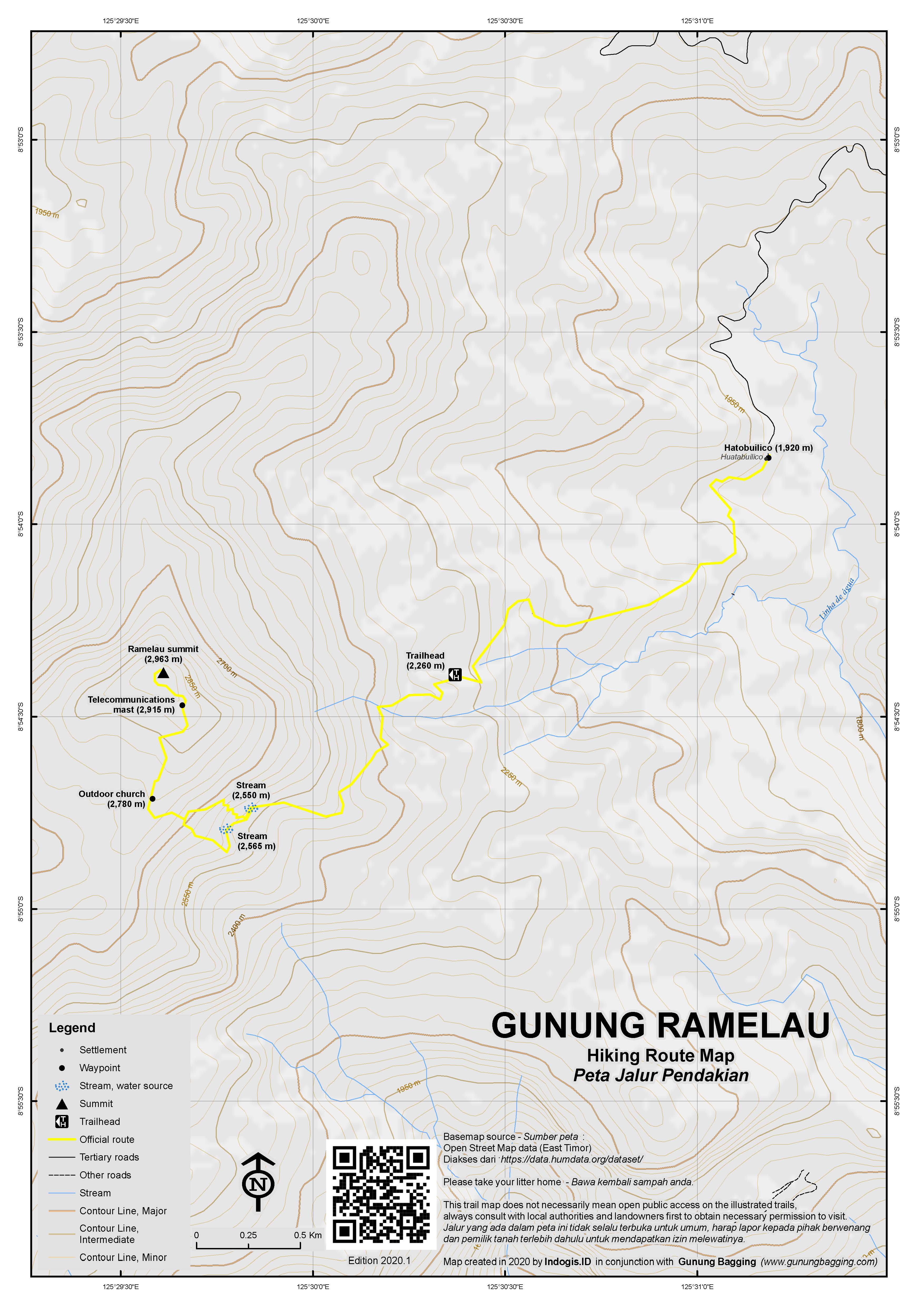
The following morning, your driver should be ready to take you and your guide(s) to the starting point which takes about 20-30 minutes to drive to from the guesthouse. You may need to get out at one point to open a traditional wooden gate across the road and there may be a landslip area (2,230m) just a couple of hundred metres before the entrance. Visitors are requested to sign in the book, but in reality this happens on your return. The entrance (2,260m) is rather grand, with a huge stone monument with quotes from, amongst others, Nelson Mandela. There are also a couple of shelters where you can charge your phone (!) as there are a number of solar panels nearby.
The first part of the hike is, if anything, a little too unnatural, with large stone steps and occasional railings leading the way up the hillside. Thankfully these do not lead all the way to the summit and before long you reach a junction (2,480m) where you must stay left. The stars should be glittering above you. Two small streams are crossed (at 2,550m and 2,565m) and represent the last place for emergency drinking water.
A further 45 minutes and you will reach a flatter section of trail to the right of which is a traditional outdoor church (2,780m) complete with rows of wooden seats for the congregation. The trail steepens after this point, passing a telecommunications mast (2,915m) before bending round to the right, up 10 or so steps to a statue of the Virgin Mary, a cement summit pillar and numerous memorials and probably a few flowers left by local people. Be careful you do not fall over the left side as it is a vertical drop of several hundred metres. Daisies grow on the few steps coming up from the other side of the summit.
As the sky lightens, you will be able to make out the south coast of the island of Timor, the ocean beyond, and a couple of wide rivers meandering their way down to it. On the left, to the northeast, is the Matebean (or ‘Matebian’) mountain range – the other significant hike in Timor Leste. To the west, in the distance, are the hills of Indonesian West Timor. To the north, as the sky continues to lighten, is Atauro island, a popular diving destination located some 25km north of Dili, the peak of which is the lushly vegetated Mount Manucoco (999m). All in all, in decent weather, dawn at the top of Timor is one of the finest views in this part of the world – and all for such an easy hike! The effort to reward ratio of Ramelau cannot be beaten!
Most hikers simply return the same way, but for those with extra time there is a trail down the other side of the mountain to the town of Ainaro from where public transport is available. If you wish to see this lesser-visited side of the mountain, be sure to tell your guides the night before so they can prepare accordingly.
For those returning the same way, you’ll have fun seeing the places you trekked through in the dark with your torch. In the early morning light there are some stunning views to be had as you descend back past the traditional church and down through the woodland to the steps and the entrance. Given that you may be taking quite a lot of photographs on your way down, it could well take a similar amount of time to descend as it did to ascend. Once down at the entrance, a local chap may well ask you to write your names in the guestbook. And then it’s back to the guesthouse for a coffee and a wash before the long ride back to Maubisse and Dili.
Information by Dan Quinn (January 2014)
Trail Map
For a high quality PDF version of this and other trail maps, please download from our Trail Maps page.
Local Accommodation
Featured Guides
If you are a reliable local guide and would like to be featured on this page to increase your bookings, or a tourist who would like to support the development of a local guide business, please email danpquinn@gmail.com with the following information: Mountain name, guide name, guide location, guide contact details, and at least one English language review from a previous hiker who was pleased with the guiding services. An example is given below for reference. We have a maximum quota of 3 featured guides for each mountain page on the site. The fee for this is £20 (British pounds sterling, typically via the Wise app or PayPal) for a period of 1 year and helps to pay towards the ongoing development of the Gunung Bagging project.
- Name and location: Pak Budi, Surabaya, East Java.
- Contact details: +62812xxxxxxxx, budi@gmail.com, https://www.instagram.com/budi_mountain_guide/
- Review from previous client: “Budi was a brilliant guide for our September 2023 trek up Gunung X and I would definitely recommend him to other tourists“, John, USA.
Practicalities
- Getting there: 3 hours from Dili to Maubisse. A further 2 hours drom Maubisse to Hatobuilico. If you have a small group and/or sufficient money it is best to hire a 4WD and driver (or rent a motorbike from Tiger Fuel) in Dili. Otherwise take public transport and expect delays!
- Guides and GPS Tracks: Want a PDF version for your phone? Looking for a guide? Need GPS tracks and waypoints? Gunung Ramelau information pack can be downloaded here.
- Trip planning assistance: Would you like Gunung Bagging to personally help you in arranging your whole trip? Please contact us here.
- Permits: Just let the people of Hatobuilico where you are going and sign the visitor book either before or after.
- Water sources: There are a couple of minor streams at around 2,550m.
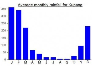
Local Average Monthly Rainfall (mm):
Location
Origins and Meaning
The name “Tatamailau” is of Mambai origin, the local language, and means “Grandfather of all”. (Wikipedia, 2011)
Links and References
Wikipedia English
Wikipedia. 2011. Tatamailau. Accessed from http://en.wikipedia.org/wiki/Tatamailau
Long ago in a small, faraway village, there was a place known as the House of 1000 Mirrors. A small, happy little dog learned of this place and decided to visit. When he arrived, he hounced happily up the stairs to the doorway of the house. He looked through the doorway with his ears lifted high and his tail wagging as fast as it could. To his great surprise, he found himself staring at 1000 other happy little dogs with their tails wagging just as fast as his. He smiled a great smile, and was answered with 1000 great smiles just as warm and firendly. As he left the House, he thought to himself, “This is a wonderful place. I will come back and visit it often.”
There was once a blind man who had so fine a sense of touch that,
when any animal was put into his hands, he could tell what it was merely by
the feel of it. One day the cub of a wolf was put into his hands, and he was asked
what it was. He felt it for some time, and then said, “Indeed, I am not sure whether it is a wolf’s cub or a fox’s:
but this I know — it would never do to trust it in a sheepfold.”
Difficult to get to this one for those who travel on a budged (but then, going to East timor on a budged is a stulid thing, since the country is so expensive compared to what you get).
Two guys rented a jeep in Dili for 175USD+fuel for a day trip and took me and my wife one way to Hatobuilico for 20USD each. Where we climbed Ramelau the same day. It takes about 2 hours starting in a village to the top.
Next day we walked all the way to Maubisse (28km) and spend a night there. In Moubisse there is a huge yellow church and in front of that church there is Maubisse cafe and guesthouse. They rent very OK rooms (in East Timor standarts, cold water) for 15USD per person with breakfast.
Next morning we took a bus back to dili 3USD each. The buses to Dili seem to go only in the morning, keep in that in mind if you want to reach Dili from Hatobuilico in the same day.
Overall we enjoyed this trip. Great views from the top and on the way from Hatobuilico to the Maubisse. We were lucky in the weather was good the first day we arrived in the afternoon, but it was still much more clearlier in the morning. It’s really better to reach the summit before 8am than to go for the afternoon hike.
I set off for Ramelau first thing in the morning from the ‘bus’ stop by the markets in Dili; it was still dark, so it was only as the light grew that I realised how many chickens and children and other goods were squeezed into the back of the open-top minibus-come-pickup truck. In Indonesian, I managed to establish that I wanted to go along the road as far as the turn-off to Hatubuilico – the usual starting point for an ascent of Ramelau. I was told that the truck wouldn’t go past Maubisse, but it would all be ok. When we got to Maubisse I was ushered off the truck and onto a proper HUGE roadworks truck (don’t get in the tray, I was told, get in the front). The truck was driven by a friendly and chatty Filipino road worker keen to practice his English and share some stories.
He dropped me at the turn-off to Hatubuilico, which is a fairly dusty non-descript spot on the side of the mountain, with some half-tyres that seem to serve as viewing stands for locals watching the world go past, or waiting for a bus. With a polite request in Indonesian, they were very happy to let me use their toilet. I walked from the turn-off to Hatobuilico – there is one little town on the way with a school, but it is quite pretty countryside (similar to parts of Australia), so I was quite content just walking. The kids at the school on the way up were quite persistent in wanting to sell me balls of gum – I’d advise not buying anything, as you’ll probably be mobbed. They did walk with me for about half an hour though, after it became clear I had nothing to give, though were too shy to chat much.
After the kids fell away I stopped for some late lunch – bring everything you need for the day. A number of locals waved to me on the way up, or even came down and chatted or invited me for coffee. It seems not too many people walk from the turn-off to Hatobuilico, and the people were very friendly.
All in all I think it was a 20km walk, dirt road, not too strenuous.
hatobuilico itself is a nice little town. Beware, it does get cold at night. I’m also told that it can be very busy on weekends. The food in the place I stayed at was simple but adequate. I went for a jog in the evening, but found that the road quickly becomes far less populated as you continue along – it had also become impassably eroded for vehicular use when I was there. A teenage boy told me he’d run with me to protect me from bad people, but I decided that was the cue to head home.
The next morning I got up just before dawn to climb the mountain. I’d arranged to go with another tourist and her guide, though she was sick so it was just the two of us. The walk up is quite nice, and though you could proabbly find the path independently, there are a couple of turn-offs to navigate, and the locals stress that you are supposed to take someone with you to get spiritual permission for the ascent. I think we got there a bit late for sunrise, but there were great views.
If you’re quite fit, on a budget, and have a bit of Indonesian, I’d highly recommend this version of the ascent 🙂
As the twelfth most prominent peak across the entire archipelago, I’d been keen on getting out here for ages and it was only really the high flight prices that were putting me off. 4 million return from Jakarta (via Bali) seems to be the best you can get for what is, of course, an international flight. Once back in Dili after the failed attempt to climb the lower (but possibly more scenic) Matebean Mane, the plan was to head up to Hatobuilico on January 1st for two nights, checking the weather beforehand to see which night would give us a better chance of a glorious sunrise. I say us – the great thing about the East Timor Backpackers is that you will meet people who might be keen on joining you on such trips, so we had a full car of 4 plus a driver arranged. This was with local firm EDS, who has taken a Danish couple up there a couple of nights earlier.
Alas, on Dec 31 st it appeared that all drivers were returning home to their villages and families so nobody would be able to drive us up there. Very annoying indeed but at least I could have a few drinks for New Year’s Eve. We would, therefore, head up on Jan 2nd and return on the 3rd, crossing our fingers for good weather. On January 2nd, about 15 minuted before we were due to leave, a phone call came in to announce that, once again, no drivers were available. I was just about to bang my head against the wall at this point. Just imagine – a car hire company that has agreed to send a car and driver unable to do the one thing the company actually exists for. How unprofessional can you get? After much arguing, they were forced to find someone to take us up to Hatobuilico and we got more than we bargained for with a very friendly and knowledgeable young chap who had spent time in Australia and was keen to practise his English.
The first 40 minutes of so out of Dili is a steep section of road with great views back over the city and the Jesus statue out on the hill by one of the eastern beaches. There’s a little museum worth stopping off at for 10 minutes or so, at a junction where you take a left continuing steeply up the mountainside. A little later the road levels and then you head down the other side through a couple of traditional towns.
Finally Maubisse is reached, and the Pousada is a must-see, perched on top of a little hill overlooking the town, with a pleasant garden including some topiary cutting. You can buy cards of pressed flowers and bookmarks in the restaurant. It’s a brilliant spot, but seems somewhat neglected considering its obvious huge potential. It took some time for anyone to come over to us (I had trouble actually paying for one of the handmade cards!) and it turned out that there was no running water so lunch at such a delightful place would not be possible. So it was back into town. Second choice was Amora restaurant, but all they had was instant noodles as they had only just re-opened after the holidays.
Third choice was back up near the entrance to Maubisse at a crowded, friendly but chaotic place where it took over 20 minutes just to get a cup of coffee.
The hike itself was great. We were up at 2am and actually stood waiting at the summit for well over an hour for the sunrise. It seemed less cold than expected, but you still need an extra couple of layers and a raincoat just incase. When the sky did begin to lighten, it turned into one of the nicest sunrises I have ever witnessed, with a bright orange and yellow glow as a backdrop to the Matebean mountains in the east. Gorgeous. And we were the first hiking group of 2014.
The car costs us 135 USD (for a day and a half) plus 40 USD for fuel. Split between 4 it isn’t bad, but doing it alone would do some serious damage to most peoples’ budget.
The following day I decided to take the public boat called the Nakroma from Dili to Atauro island. Just 5 USD each way for one of the green tickets (for airconditioned seat) it was a bargain but be sure to get there before 8am as it left at 8.10am rather earlier than the 9am I had been told. It takes about 2hr 40 minutes to get over there, and on the way out you might be able to make out Dola Koyakoya at the eastern end of Alor island in Indonesia. One chap at the Backpackers had hiked up to the top of Atauro island (Mount Manucoco) a couple of days before and had told of great views but the need for his guide to use a machete it was so overgrown. I wouldn’t have time for this unfortunately.
Alas it turned out I didn’t have much time for anything as there was a mob of almost 200 people standing round the primitive ticket office waiting to buy a ticket for the return journey to Dili (leaving at 3pm). The authorities are so hopeless as to not offer a return ticket or the option to buy one in advance in Dili. So half of my 4 hours on the island were spent trying to work out how to get a ticket back (!) and not get involved in the mob surrounding the ticket office (which seemed to be empty for the first couple of hours anyway!).
Luckily a very pleasant local chap who works for the NGO Move Forward on the island helped me ensure I would be able to get back again the same day (and therefore get my flight back to Jakarta the following day). Without him it could have been difficult. I did have time for lunch at Barry’s Eco Lodge just a 3 minute walk to the right along the beach from the pier. The alternative way to get back is an expensive seat on a speedboat (40-50 USD one way) and I was half considering spending a night there instead of having to rush back. The island has a great deal of potential, and with just a little bit of initiative could be a great tourism spot. How much does it cost to put up a basic map of the island at the end of the pier? Is that such a radical idea? Well, at present there isn’t one, and your best source of info is at Barry’s Eco Lodge. Those without a guidebook of some sort would be completely lost if they arrived on the public ferry.
Of course the flight back to Jakarta was delayed by over 2 hours because Bali’s supposedly international airport had had a power cut all morning so people were queueing in the darkness whilst airline staff wrote tickets and checked luggage in by hand! What a shambles! And in addition, immigration had only 1 of 7 booths for foreigners open. Welcome to Indonesia!!!!
i’ve been solo hike to this mountain, you can check my field report at
http://www.kaskus.co.id/thread/50cd9220621243d869000000/share-solo-hiking-ke-gunung-ramelau-timor-leste/
BAGIAN CABLAQUE AITUTU ADALAH TTLSAYA. TAPI SAYA SEKARANG SUDKOREA
Dan,
Hello, please also include mountain in Papua New Guinea. There are many Sangat Tinggi Ribus there 🙂 and they are all quite remote areas so that very interesting for expedition : )
Regards,
Dasmir