
Facts
- Elevation: 990 m (3,248 ft)
- Prominence: 990 m
- Peak category:
 Spesial
 - Region:
 Papua Barat (West Papua)
 - Island: Waigeo
- Coordinates: -0.0417, 130.8517
- Rating:


 (3 votes) Add your rating
 Loading...
 - World Ribus ID: 80099
Bagging It!
This Ribu is the highest point of Waigeo island, also sometimes spelt Weigeo. We previously thought Gunung Mandum (estimated 977m) was the highest, a peak of similar height lying way inland, but SRTM suggests this un-named peak is a little higher and both a botanical survey of 1959 and the modern BBKSDA (local authorities) suggest Gunung Samlor is the highest at around 1000 metres. A US Army maps gives an elevation of 3,280ft which is 999.7 metres….. as close to a borderline Ribu as it gets. But ALOS suggests nothing over 984m or so. Therefore we are using 990m for now until more data becomes available.
Gunung Danai (also on Waigeo) is allegedly 978 metres, so a similar height. Also in the area is Gunung Nok, a very shapely peak whose name means Mount Buffalo Horn, which can be hiked from the west coast at Waifoi where ecotourism began in 2016. It too is not far off the 1000-metre mark.
Practicalities
- Getting there: Unknown
- Permits: Unknown
- Water sources: Unknown
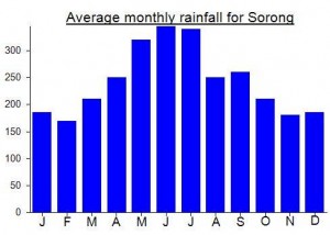
Local Average Monthly Rainfall (mm):
Location
Click on the blue arrow ![]() (top right) to see your current location on the map
(top right) to see your current location on the map
Some very useful info here http://www.eco-communications.net/2010/06/21/pulau-waigeo-kabupaten-raja-ampat-west-papua/
including that the “highest elevation of Waigeo, according to a botanical survey report of 1959, is Mt. Samlor (about 1000 m).”