Facts
- Elevation: 2,675 m (8,776 ft)
- Prominence: 1,329 m
- Ribu category: Tinggi Sedang
- Province: Jawa Barat (West Java)
- Google Earth: kml
- Rating:

 (19 votes) Add your rating
 Loading...
 - Other names: Known as ‘Panénjoan’ in ancient times according to the Bujangga Manik Old Sundanese (Hindu) text in which the main character climbs Papandayan and sees a panorama of other peaks both near and far, based in both reality and his imagination. Its other name Panénjoan means “panorama, vista”.
- Eruptions: 1772, 1923, 1942, 2002
Photos


Bagging It!
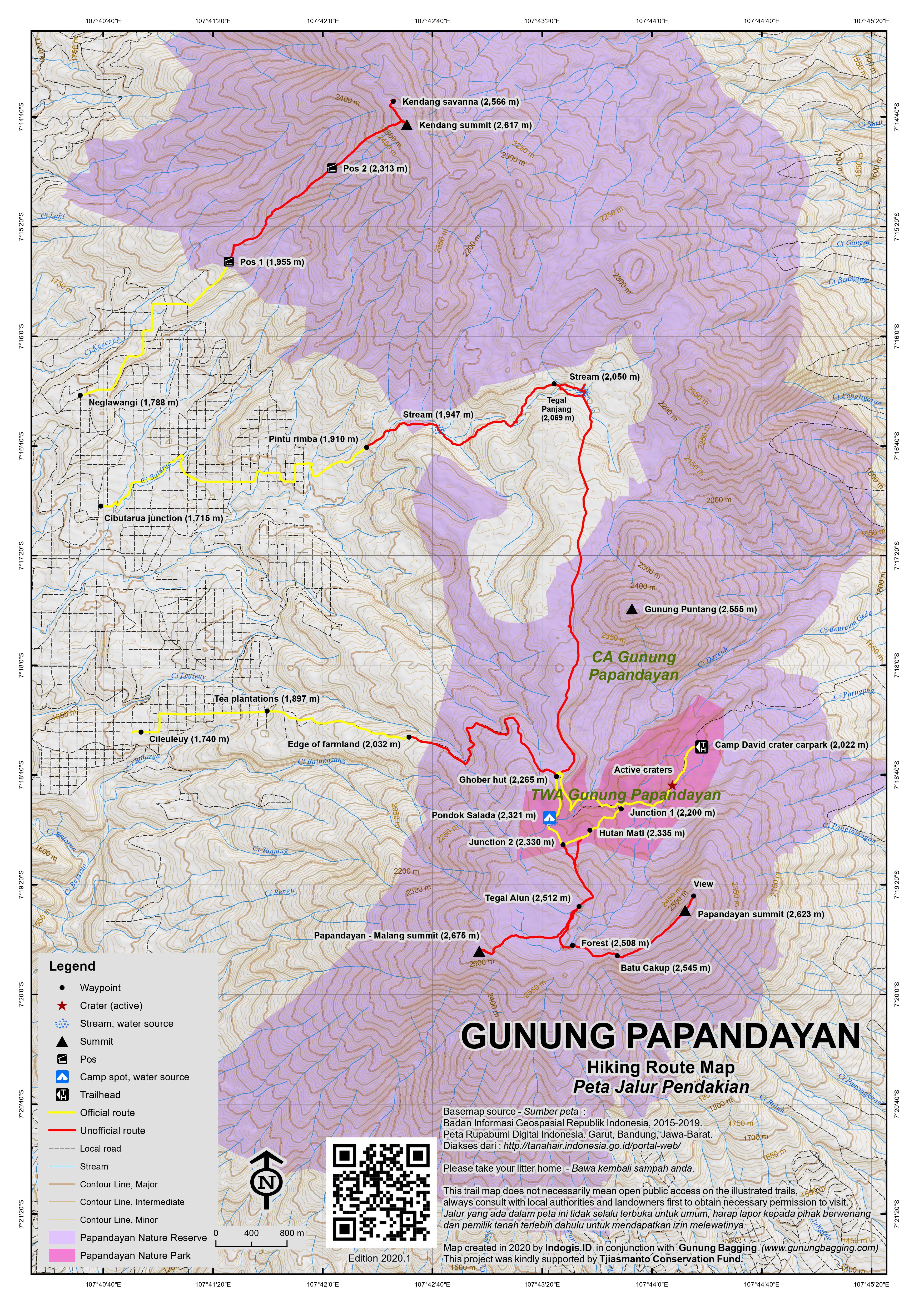
This Ribu is located about one hour’s drive from the town of Garut and actually has a car park at over 2,000 metres above sea level on the edge of the active craters. There is an alternative route to the mountain from Cileuleuy and Pangalengan but the approach from the main crater is by far the easiest and most popular. The scenery is some of the most spectacular and varied in West Java and the active crater attracts a lot of tourists. From Garut, take the road which leads via Samarang and Bayongbong to Cisurupan. Take a right turn here, or take one of the many ojeks (motorbike taxis, approximately Rp 30,000 each), and follow the occasionally bumpy road 8 kilometres up to the warung-surrounded car park. The entrance fee changes according to whether it is a weekday or weekend and is a ridiculous Rp 200,000/300,000 for foreigners and a much more appropriate Rp 20,000/30,000 if you’re Indonesian or have a KITAS/KITAP. Additional parking and camping charges apply.
Mount Papandayan has several summit craters and is very much alive, volcanically speaking. The most catastophic eruption was in 1772, but there are fairly regular eruptions, the last major one being in 2002. Apparently the mountain was over 3,000m high before the 18th century eruption though how this is known is unclear. Exploring the active crater is easily done in less than an hour. Further on, there are several peaks of a seemingly similar height, the principal and outer two being named Papandayan and Puntang, with various minor tops between them, one of which is the very rarely visited highest point in the mountain massif called Gunung Malang on Bakosurtanal maps.
From the crater carpark (2,022 metres up the mountainside, known somewhat bizarrely by local trekkers as ‘Camp David’!) it is a fascinating walk through the incredible crater scenery (sulphur clouds, rivers of steaming water and even bubbling hot mud pools at 2,190m). This part of the hike is very popular with tourists, some of whom do not venture further. Sometimes warnings are in place which prevent you from walking through the crater (most recently in August 2011) but remarkably some local people still use the trail as a villagers’ route to Cileuleuy and the vast tea plantation area south of Pangalengan. Indeed, you may even see one or two motorbikes go past across the crater.
The imposing 2,623m mountain to the south/south-east of the crater that actually forms the crater wall is called ‘Gunung Papandayan’ and is one of the highest peaks in the mountain range (many will tell you it is THE highest but they are wrong). It’s a tough 5 hour trek up there via various fascinating and varied landscapes and you definitely need a guide. The main crater path climbs round to the west, past the bubbling pools of mud (and previously a sign for ‘Balagadama crater’), and up towards the edge of the active crater scenery. From here, there are two routes to choose from. A left turn on a very pleasant new path (constructed in 2017) between the lovely Pohon Suagi bushes (Vaccinium Valium) with edible berries, following the edge of the crater leads you steeply up towards a small plateau of burnt trees (‘Hutan Mati’ 2,335m), avoiding and just beyond the moderately-popular camping area of Pondok Salada (2,321m).
It’s the quickest way of getting to the highest areas of the mountain range known as Tegal Alun (2,512m) – just 2 hours for fit hikers – but in recent years access has become unclear, with some saying no camping is allowed there and other sources suggesting nobody but researchers are allowed that high up the mountain.
The other option is straight on over the edge of the active crater scenery on a trail that will lead you to a cobbled track through an area of rich vegetation and some excellent camping areas. A huge landslide (which occurred in the eruption of 2002) destroyed one large section of the cobbled track and this means that you have to take a right down and across a river before ascending again back to the cobbled track. When you reach the saddle, there is a grassy area (2,265m) known as ‘Ghober Hut’. There used to be a couple of wooden huts but they were demolished sometime in early 2011 though may have by now been replaced.
This is a very important crossroads on the mountain and there are three options. Straight on on the wide farm track will lead you all the way down to the vast and beautiful tea plantations near Cileuleuy on the other side of the mountain. This makes an interesting alternative route down after you have finished your hike and if you have lots of time to slowly work your way back to Pangalengan and Bandung by ojek and minibus. However, access remains unclear at present due to nature reserve regulations.
The second option is a right turn along a track leading north out to Gunung Puntang, a 2,555 metre high forested peak. Unfortunately there is no trail at present to the top of the densely-forested peak but a 10-minute wander in the direction of Puntang offers wonderful views to Gunung Cikuray. (After that the trail descends into deeper forest, skirting the wild Puntang peak itself. Apparently an aircraft crashed into this remote area c.1992. There is no litter here because of how infrequently the trail is used by hikers, but it too is an area that is part of the nature reserve and therefore access may not be possible for ordinary hikers.
Local farmers and hunters sometimes traverse this incredibly wild area, which is populated with a large number of wild pigs ‘babi hutan’, and descend northwards to a large treeless area clearly visible on the satellite view on Google Earth and Google Maps called Tegal Panjang (c 2,069m – see further information below) before heading down into local villages. Perhaps local hikers will one day open a route to the Puntang summit but for now most regard it as a rather mysterious peak.)
The third option is a left turn towards the popular Pondok Salada and beyond to the highest parts of the mountain range. A path on the left of the two wooden huts leads up and then down through forest to the pleasant camping area known as Pondok Salada (2,320m). On the way there you can admire the views back down over the active crater. It’s a beautiful spot but do take note that there are lots of wild animals in the area – wild pigs, wild dogs and perhaps even some ‘big cats’ – so campers are advised to go in large groups.
Continuing further on, if allowed to do so, on the left of the boggy area and up through a sandy area with dead trees (near Hutan Mati, where the short cut from the active crater meets this trail), and steeply up the mountainside. Less than an hour beyond Pondok Salada is yet even more fabulous scenery called Tegal Alun where swallows swoop and dive. It’s a vast grassy meadow of extinct crater areas and has plenty of large flat open plains (2,512m) ideal for camping (if the prospect of beasts lurking in the bushes doesn’t put you and your group off) and lots of Javanese Edelweiss. In mist it is an incredibly eerie place and there are many dead trees and small clusters of bush. You are unlikely to meet any other hikers here and the official camping place is back at Pondok Salada.
The very highest point of Papandayan (2,675m) is actually an unmarked spot known as Gunung Malang in moderately dense vegetation 140 metres above to the west of the vast open plains and presumably formed part of an ancient crater wall many centuries ago. It seems unlikely that more than a handful of people have visited this true peak in recent decades as it is overgrown and now part of the nature reserve.
It takes about an hour from Tegal Alun to reach the highest peak (Malang) and you are advised to take a GPS with you and request official permission from the authorities in advance. It is not the broad, flat top with numerous rocks on it which lies in front of you when you first enter Tegal Alun but rather one of the peaks further to the right. If you do manage to reach the top and don’t get lost in the spiky vegetation, you can be back down at the carpark from Malang peak via Hutan Mati in just over 2 hours.
There is also a trail from Tegal Alun to the second highest peak known as ‘Gunung Papandayan’ and incorrectly assumed by local guides to be the highest point. It is the mountain you will have admired from the crater carpark and lies beyond Tegal Alun and to the left (east). It too may be off limits to ordinary hikers.
In 2017 there was a red sign with ‘Puncak’ written on it at Tegal Alun and with an arrow pointing left. This ‘puncak’ refers to Puncak Papandayan not the higher Puncak Malang. After skirting along the left side of Tegal Alun, the faint path drops down slightly to a small boggy area. It is very difficult to find the trail without a guide as it then snakes through dense undergrowth growing among dead tree stumps before climbing the ridge of the actual mountain which you will have seen as the active crater’s back wall from back at the carpark.
It takes about 90 minutes to reach the peak from Tegal Alun and there are some stunning views back down to Tegal Alun, Pondok Salada, the active craters below and many other distant mountains from the higher sections of the ridge. One landmark that guides will know is ‘Batu Cakup’ (2,545m) which is basically a section of the trail where there are a couple of large boulders. You can sometimes see the south coast of Java from here.
The Papandayan summit (2,623m, second highest after the numerous bumps on the Gunung Malang ridge) is marked with a little flag but offers only limited views to the active craters below. Keep on hiking beyond the highest point for another 200 metres for the best views directly down the cliffs of the crater walls to the new crater (including a small lake). You are likely to see birds of prey in this area.
It takes about 3-4 hours to descend the same way back through Papandayan’s wide array of splendid scenery, although there is supposedly a short cut back to the car park which simply continues beyond the highest point and follows the ridge back down. Apparently it takes about 2 hours to climb down from the peak to the car park if using this route (should permission be granted). Of course, you could climb up this way to begin with but then you would miss all of the beauty of Pondok Salada and Tegal Alun.
Bagging information by Daniel Quinn (updated June 2017)
Gunung Kendang (2,617m)
About 8 kilometres to the north of the Papandayan area, east of the vast tea plantations near Pangalengan, is another high mountain called Gunung Kendang. It is essentially a large extension of the Papandayan range, but feels separate enough in its own right to have been a key target for many keen local hikers in West Java for many years. Sadly, as is the case with many of the mountains in West Java, in the last few years access has been restricted as large areas of forest have been accorded the status of nature reserve (‘cagar alam’) and therefore only accessible to scientists or similar conducting research.
Although many local hikers have not always treated mountains with sufficient respect in the past, by leaving rubbish behind and so on, it seems quite drastic to prevent ordinary, responsible people from exploring so many beautiful, wild places of West Java. Anyway, for now, Gunung Kendang is officially shut, but should you be a researcher, or get special permission, or should the status of the trail change yet again in the future, then the following information may be useful.
The trail to Gunung Kendang starts in a small village called Neglawangi (1,788m) which is about one hour by car or motorbike from Pangelangan via the very scenic villages of Santosa, Talum and Sedep, and with good views of Wayang-Windu. The trail initially leads through tea plantations before entering forest (Pos 1, 1,955m, less than one hour). A ridge leads all the way up to the summit and on this ridge are Javan edelwiess plants, cantigi, and a large number of pitcher plants, now sadly a rare sight in Java.
The views over to Papandayan and down to the tea plantation are beautiful in clear weather. Pos 2 is at 2,313m and a junction is reached at 2,600m (after about 3 hours in total). Just two minutes to the right is the summit of Kendang, with a lonely, rusting metal sign. There is no view here and no reliable water sources. Down about 15 minutes to the right is a large clearing, allegedly formerly a lake, but most likely to have been a crater in ancient times. This is known as ‘savanna’ (2,566m) and used to be the main camping spot for hikers in recent years, although a day hike is also possible as fast hikers can be back down at Neglawangi in just 2 hours.
From the summit area, a powerful, continuous sound of gas explusion can be heard. This is either an inaccessible crater on the eastern side of the mountain, or more likely the geothermal plant at Darajat Pass – again on the eastern side of Kendang (the Garut side), and apparently with no trail between there and the summit or savanna. The 2,608m figure which is shown on some maps is thought to possibly refer to the height of the seemingly slightly lower northern top which is just to the north of the savanna.
Tegal Panjang
Tegal Panjang (2,069m) was popular with local hikers for a few years (2010-2015) on social media as one of the best spots in West Java to take photos of a large expanse of meadow surrounded by forest. The area is about one kilometre long (hence the name ‘panjang’ meaning ‘long’) and a couple of hundred metres wide.
Sadly, the forestry authorities decided to close this spot (along with tens of others) to all but scientific researchers, but some hikers still visit occasionally from the Pangalengan side. In reality, a handful of local people still use this trail as a short cut from the Garut side to the Pangalengan side of the range. If if officially re-opens to responsible visitors or you are lucky enough to be one of the chosen few, then the following information may be of use.
It takes around 90 minutes by motorbike (or preferably 4WD or trailbike) from Pangalengan to Cibutarua (1,715m) which is a village in the tea plantations about 30 minutes beyond Neglawangi mentioned above in relation to Gunung Kendang. There is a sign for Tegal Panjang by a road junction with a very small warung near the corner. Some hikers trek in from here (requiring about 3-4 hours up and 3 hours down) but others save an hour each way by taking their bikes 20 minutes up into the tea plantation and leaving then at an unmarked corner (1,830m).
From here the narrow trail drops down briefly before leading up through cabbage, potato and carrot fields, and past some huts (1,855m) where there are a handful of truly beautiful rainbow eucalyptus trees. A pool marks the entrance to the forest (‘Pintu Rimba’, 1,910m). There are no signs on the trail, but an occasional ribbon tied to branches and normally pleasant of local farm workers on the crop fields at the edge of the forest.
Once in the forest, the trail basically leads up gently with one or two steeper parts, and is never too far from a stream (especially at 1,947m). The first crossing in the forest is over a slippery, rotting footbridge where care needs taking. Given that Tegal Panjang is under 2,100m, the elevation gain required on the trek is minimal and the main obstacles are the numerous fallen trees that block this once-popular path.
Fast hikers can be at the edge of Tegal Panjang in under 90 minutes from the start of the forest. This is a grand view, with a character depending on the time of year and the weather conditions. After the rainy season the meadow is a lush green, and at the end of the dry season it is a yellow-brown. This area is known to be an important place for wild animals, and you can indeed imagine Javan tigers once roaming here in centuries past.
A deep, curving mini river valley cuts through this north-western end of the meadow, with a few trees growing, and an almost always reliable water source. There are also deep holes in one or two places that need to be avoided. A trail to/from the Garut side of the range starts to the left of the meadow, just before the crossing of this ‘mini river valley’, near a large tree on the edge of the forest, and a flat area clearly once used for camping. But Tegal Panjang itself stretches on for a good kilometre to the south-east, and the other trail that skirts by Gunung Puntang (enroute to the main crater of Gunung Papandayan) presumably leads into the forest at the far southern side of Tegal Panjang.
Back at the edge of Tegal Panjang on the Pangalengan trail side, there is a prominent memorial to a hiker who sadly died nearby in January 2015, near the slippery footbridge not far from the start and due to hypothermia in very bad weather according to locals.
Trail Map
For a high quality PDF version of this and other trail maps, please download from our Trail Maps page.
Local Accommodation
Featured Guides
If you are a reliable local guide and would like to be featured on this page to increase your bookings, or a tourist who would like to support the development of a local guide business, please email danpquinn@gmail.com with the following information: Mountain name, guide name, guide location, guide contact details, and at least one English language review from a previous hiker who was pleased with the guiding services. An example is given below for reference. We have a maximum quota of 3 featured guides for each mountain page on the site. The fee for this is £20 (British pounds sterling, typically via the Wise app or PayPal) for a period of 1 year and helps to pay towards the ongoing development of the Gunung Bagging project.
- Name and location: Pak Budi, Surabaya, East Java.
- Contact details: +62812xxxxxxxx, budi@gmail.com, https://www.instagram.com/budi_mountain_guide/
- Review from previous client: “Budi was a brilliant guide for our September 2023 trek up Gunung X and I would definitely recommend him to other tourists“, John, USA.
Practicalities
- Getting there: From Jakarta, take the toll road to Bandung and continue beyond to the end of the toll at Cileunyi. Follow signs to Garut and then take a right turn towards Cikajang. The road to the crater is signposted at Cisurupan. Primajasa buses to Garut leave from Jakarta’s Lebak Bulus and Cililitan bus depot frequently during the day (Rp52,000 in 2017). Angkots run from both Bandung and Garut to Cisurupan but you need an ojek (plenty available) up to the crater itself. The alternative approach from Pangalengan requires public transport (bus from Bandung to Pangalengan Rp25,000 and two hours) and probably ojeks too or hitching a ride with plantation workers.
- Guides and GPS Tracks: Want a PDF version for your phone? Looking for a guide? Need GPS tracks and waypoints? Gunung Papandayan information pack can be downloaded here.
- Trip planning assistance: Would you like Gunung Bagging to personally help you in arranging your whole trip? Please contact us here.
- Permits: Entrance ticket required at Camp David. An expensive Rp200,000 / 300,000 for foreigners or Rp20,000 / 30,000 for locals and those with KITAS/KITAP. The higher price is the weekend or public holiday price. You may get a discount for large groups. Additional parking and camping fees apply – and foreign tourists have to yet again pay more than locals for the camping! Access to many of the peaks in the nature reserve is difficult now and permission must be sought in advance and is not always granted to hikers.
- Water sources: Available at Pondok Salada (2,321m).
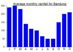
Local Average Monthly Rainfall (mm):
Location
Origins and Meaning
Mount Smithy’s Forge. Papandyan probably comes from the base-word panday or pande meaning “blacksmith, ironsmith, metal artisan”, and papandeyan is “the place of the ironsmith” i.e. the fire in which the ironsmith forges his metal. So the name papandayan probably refers to the volcanic crater of the mountain. (George Quinn, 2011)
Malang means ‘sinister’, ‘poor’, ‘dismal’ or ‘wretched’.
Just went up to Hutan Mati today, and the whole area seems still very much as described above. It’s an absolutely stunning mountain and well worth the journey. Prices are still the same as quoted above – 20rb/30rb for locals/KITAS and 10x that for non-KITAS foreigners. It is very popular, so please be ready for all that goes along with that – ojeks, warungs, selfies, etc. But still stunning.
Alas it is still not allowed to go to the peaks, and there are *lots* of signs saying so. You can hike the full permitted circuit from the carpark in a leisurely 3-ish hours (without availing of the ojeks). I would like to be able to check off the peaks, but the scenery in the permitted area is absolutely fully worthwhile anyway.
There was a very interesting article in the Jakarta Post a few days ago about a study using camera traps from 2016-2018 that found 10 Javan leopards in the ‘Guntur Papandayan conservation forest’. The article says they are active between 6 and 8 am and 10 and 12 at night. It is not clear from a simple online search the exact area that this covers but clear Gunung Papandayan and Gunung Guntur are major parts of it. I am not at all surprised, especially about Papandayan as the higher parts of that mountain always felt very wild indeed and I had a feeling of being observed up there on more that one occasion. It’s great that these endangered creatures are still surviving, but it seems some logging is still going on. It would appear the true peaks of both ranges are now out of bounds which is a bit of a shame to say the least.
Set off on Friday night for a weekend of bagging in West Java. First up…. A return to Papandayan and a proper attempt to reach the true highest point of the range (Gunung Malang 2675m). I took the trusty Primajasa bus from Lebak Bulus towards Garut (2017 price a very reasonable Rp52,000) and got off at Cipanas. Took about 5 and a half hours (typical Friday evening traffic). There was a lot of work going on at Cipanas – it’s the sort of place that never feels like it is finished. Excellent natural hot water from Gunung Guntur (‘thunder mountain’) though, direct into the mandis of the hotels at the far end of the road. Alas my hotel bed had bedbugs so I ended up sleeping with my clothes on.
Ramdan picked me up at 5.30am on the Saturday morning and we set off for the renovated ‘Camp David’ parking area 2000m up the Papandayan mountainside. Some considerable improvements to the road and the parking spots have been made since my last visit a few years ago, plus numerous new buildings and stalls, but the entry prices have also rocketed, most notably for foreigners (those who don’t work/ pay tax in Indonesia). Entry ticket alone is a ridiculous Rp200,000 and that’s just during the week. At the weekend, you can expect to pay Rp300,000. Quite how most backpackers would then be able to afford a guide, food, transport and accommodation on top of such a fee is something the powers that be have not thought about and perhaps have no interest in. They want to attract tourists apparently – I imagine a considerable number reach the ticket barrier and decide not to bother. Luckily for me, I have a KITAS so (after some discussion) I get the local rate (rp20,000 weekdays and Rp30,000 weekend), but it’s hard to encourage the less fortunate overseas tourists to spend this sort of money merely to be allowed to ‘be there’. Do foreigners create ten times the amount of trash that a local person leaves behind? Highly unlikely…. But then it’s my mistake in seeking any logic.
Along with newer facilities, there are several new bamboo huts near the main crater area and in the last six months a brand new stone path has been constructed, leading directly from the main crater up to Hutan Mati (Dead Forest). This means if you are heading to Tegal Alun you don’t have to drop down and back up again to the Ghober Hut and go via Pondok Salada and so you can be up at Tegal Alun in 2 hours.
Once we got to Tegal Alun, Ramdan showed me where he had taken Pauline a couple of years ago – a lower point on the Malang ridge, but according to my data definitely not the highest point of the whole mountain range. So we would push through and make our own way to what the Bako map and Google Earth data had long been telling me was the highest point. It was tough going – spiky plants and crumbling, steep, overgrown earth with numerous holes. Anyway, the weather was on our side and the views soon really opened up, as I gave Ramdan information on how many metres away from the peak we were, and how much more elevation gain was needed. We reached the ridge in just 45 minutes and in another 15 were at the true highpoint of Gunung Malang, Papandayan. Highest GPS reading was around 2683, which ties in with the 2675m on the Bako map. We had done it! Finally! My last unclimbed Ribu in West Java! Even more impressive – Ramdan had been fasting and so had made it up here with no food or water. In just 3 hours from the car park.
I decided to mark this spot somehow, so that others would hopefully know they were at the right point (though who knows how long it will be before the next group of hikers climb Gn Malang?) I couldn’t leave my batik shirt there as I needed it for work, so I left a friend’s blue shirt tied to a tree at the highpoint! A friend in Malang – whose old shirt is now on Gunung Malang.
From this spot, there are limited views over the other side due to the small trees, but back down to Tegal Alun and Gunung Puntang beyond is a lovely panorama.
Surprisingly, on the way back down we found a tree with 7 names written on it in black marker pen. Hikers from Bandung who had been up here in 2015. Well done! So we weren’t the first in modern times after all. We were back down at the car park in 2 and a half hours, and that includes several breaks to take pictures. The very keen could probably naik-turun in 5 hours, though anyone else considering this is advised to use my GPS tracks (check the page later this week) and go in the next month or two and take Ramdan with you (he also has accommodation in nearby Cisurupan should you need it).
I got on an ‘elf’ (mini bus thing) at the main road bound for Bandung Leuwi Panjang (Rp35,000 or 40,000) but the driver was stopping for a break every 5 minutes and then complaining to me about the lack of passengers (trying to make me pay more just so he would continue with the journey to Bandung). Those who can’t be bothered with this sort of crap are advised to get a rather more professional Primajasa bus from Garut bus station.
Then it was time for a few celebratory beers in Bandung, though in white mugs and unusual jars rather than overtly swigging from the bottle, what with it being Ramadan.
Hi Dan,
Can I have Ramdan’s contact please?
Vinchel
+62 857-5939-0341
Hi, can i check how much does it cost to hike mount papadayan if the vehicle will drop off at the carpark already. And is it complusary to get a guide? thanks! Appreciate any advice!
I haven’t been for years but I know prices have rocketed for foreigners (or those without a KITAS permit etc). Could be in the region of Rp250,000 (ten times the local price). May be higher at the weekend or public holidays. Guide probably not compulsory just for a quick hour’s walk round the main active crater area but if you want to go higher u I would definitely recommend one as it can get very confusing if the clouds come down. I aim to go again later this month or next month so will do an update soon.
Hello Dan, how many hours would take a round trip “Camp David – Dead Forest”? I’m a solo traveller and would not like to spend a night in a tent, I would like to do this hike during the day. Is it possible?
Many regards
Very easy Mark. Half a day is sufficient to explore quite a bit of the mountain.
Great… many thanks!
By the way, there is a sign now on the summit that can be reached by the trail that is described here. It indicates an altitude of 2622 m.
The walking times in the description are for very slow walkers. For normal hikers you must discount at least one hour for going up and another hour for going down.
The short cut to the summit is recommendable only going up. It is very steep and can get really a bit difficult when you take it going down. The first time I went to Papandayan I came down the short cut – never again. The second time we took it going up and took the long way going down. This is a very nice roundtrip. Papandayan is one of the best hikes you can do on Java, even if it is quite short and easy. It is definitely one of the most beautiful.
Hi Matthias. This is incorrect. You are confusing ‘Papandayan’ summit with ‘Malang’ summit. The second is higher and not properly accessible unless you fight through bushes. Malang is the highest peak in the range – a good 40 or 50 metres higher than the ‘Papandayan’ peak with the sign that you visited.
Hi Paulina, many thanks for the recommendation. will it be possible if i discuss with you some details via email? please email me at oahaji@gmail.com, i would like to seek more details as my girlfriend and i will be attempting to hike for the first time.
thanks again!
JH, Please do hire Rhamdan 085321821557. He is a great guide.
He can give you clear instructions how to reach Cisurupan by angkot. From Cisurupan he can take you to Camp David on his motorcycle.
Last May, I took a taxi from Bandung to a certain bus station nearby and he met me there.
** The advantage of hiring him is he knows the way to the summit of Mt. Malang **
April should be a good month to hike.
Have fun. It’s a gorgeous place to be.
Hi Dan, I’m interested to go to Papandayan but I do not have contacts to any guides, would you be able to advise me on how to get to Camp David from Bandung?
Also, would it be suitable to hike up Papandayan in the month of April 2015? Many thanks for your kind advice..
Cheers,
JH
Hi, Dan,
Just returned from Papandayan with Rhamdan and Pak Ujang.
With the help of Pak Ujang and his machete, we reached the summit of Gunung Malang.
Please go there while the trail is still new.
For detail info please contact:
Rhamdan 085321821557
Pak Ujang 087725456664
Photos can be seen on my FB which is opened to the public.
Video will be available on youtube soon, so please check http://www.youtube.com/epwerthen
Cheers…
Well done Paulina. Nice video too. http://www.youtube.com/watch?v=Nu74NQuBnjY
Hi Dan,
We, 16 people, just went to Papandayan 27 – 28 October 2012. Many hikers were there to commemorate “Sumpah Pemuda” (Youth’s Promises, 28 Oct 1948) in Pondok Saladah.
This is my second time, but I never really reached the Papandayan summit due to time concern, Tegal Alun is the highest for me at the meantime.
Could you explain where is actually the first highest Malang Summit? You mentioned that Thomas and Heinz almost reached the highest? Was that Malang Summit?
Thanks
Hi Zulfadhli.
Good stuff. The Malang summit is behind Tegal Alun, full of trees and bushes. On the Bakosurtanal map you can see it clearly-marked. But there is no proper trail. Apparently Thomas and Heinz got close to the top with a farmer. But still about 300 metres away from the real highest point.
You know much ya Dan… 😀
Let us know if gunungbagging team is going to reach the highest summit again…
Just back from another trip to one of West Java’s finest mountains. Stayed as usual at the rather dirty Tertamerta 1 (155Rp per night) at Cipanas where the hot water was wonderful but definitely slightly hotter than in previous times. Took me ten minutes to get in. I was picked up by Dede (see guides page) at 3.30am and whisked up to the crater carpark. The place was buzzing by 4.30am with well over 100 hikers from universities (MAPALA clubs) off to spend malam minggu at Pondok Salada and scare the lurking beasts away with their music and giggles.
I had previously told my guide I wanted to reach the top of the Puntang peak (an area I had not explored) but for some reason he ignored the important word ‘puntang’ and assumed I must want to climb to the top of the Papandayan peak. Anyway, after traipsing through a misty Papandayan crater at dawn I convinced him we should give Puntang a try as I had already explored other areas of the mountain many times.
So we reached the grassy Ghober Hut junction and turned right, past various old camp fires and down into denser and denser forest. Very little litter to be seen and lots of bird life in the trees. Sadly the trail only led further and further down the mountainside and we found no evidence of any routes up to the actual peak itself.
So back down to the crater carpark it was, to enjoy some newly-fried ‘bakwan’ before I headed off to have a brief look at the ancient Cangkuang temple and in the direction of Cicalengka and the next night’s climb, Gunung Kerenceng.
Heinz and Thomas made a serious attempt to reach the high point with the help of a farmer last weekend. From their GPS readings it would appear they were just 300 metres away from the true summit – closer than anyone else so far that we have heard from. I wonder how many people have actually gotten to the top in the last 100 years…. maybe none!
It would appear that Papandayan is about to erupt…..as it says in the article, if it blows before or as everyone is leaving Jakarta for the kampungs it could cause serious transportation chaos. Additionally, if it is indeed bigger than in 2002, it will be pretty huge considering that the 2002 eruption caused major landslides and reshaped the mountain.
http://www.thejakartaglobe.com/home/volcano-agency-warns-of-likely-papandayan-eruption/461307
Indonesia’s highly active Mount Papandayan volcano is in imminent danger of erupting, the Volcanology and Geological Disaster Mitigation Agency warned on Wednesday.
The agency, known as the PVMGB, said it was likely the volcano in Garut, West Java, would erupt either before or just after Idul Fitri, which marks the end of Ramadan.
The prediction was based on the increasing activity of the volcano, the agency said on its Web site.
“The volcano has more energy compared to its last eruption in 2002,” agency head Surono said in Bandung, the provincial capital, on Tuesday.
Papandayan has shown an alarming increase in activities since the volcano’s status was raised to standby. Between Aug. 19 and 20, there were 45 earthquakes.
“If the quakes increase to 60, an eruption will happen,” he said. “If Papandayan erupts, the annual exodus [mudik] routes will be blocked and 16 subdistricts in Garut will be isolated.”
The agency asked officials at the National Disaster Mitigation Agency (BNPB) to stay alert.
The head of West Java’s BNPB, Ujuwalprana Sigit, said it had prepared multiple quick-response strategies for the possible eruption.
The BNPB has prepared evacuation routes and emergency shelters for people living within 5 kilometers of the crater.
Hi Dan,
By reading your post above, it reminds me of my experience in 1997. I climbed Papandayan with three other friends. There were only two groups in Pondok Salada, and our tend was a bit further than the other; it was near the hill where you can climb and walk to Tegal Alun (it may be different now).
That night was quiet until someone from the other tend started to scream. Two friends of mine went down to check and afterwards they returned back to our tend and said someone was hallucinated. Afterwards, we decided to sleep but we couldn’t because we heard sounds of animal walking outside (presumably was big cat or dog) and started roared and was scratching the tend. We tried to be as quite as possible and hoping the beast would be gone. By the time the night went by, we couldn’t really sleep…particularly me because I could hear very noisy sound like people running and also woman’ voice, which apparently it was me the only woman in the camping ground. Finally the morning came, and we dared to get out from our tend. We could see animal footprint (only two feet) and two others human footprint all over the tend. Believe it or not, we could see those prints. Afterwards, we decided to move our tend a bit closer to the other one, and we still stayed for another night because our logistic (food) was still plenty 🙂
It was my third time climbing Papandayan, and that experience didn’t stop me to comeback in 1998 where I celebrated my 19th birthday there. We climbed to Pondok Salada bringing birthday cake and prestigious mpek-mpek 🙂 It was so much fun!! Although, again we had to go down earlier than our plan (5 days) to the base camp near the parking area because a friend of mine was “ill” after the 3rd day. I knew it would happen after I saw a girl in yellow sweater kept looking at to our tend on the first night. But none of my friend believed to what I saw.
Now, after more than 13 years I really want to comeback and see how Papandayan is after so many eruptions. I hope I still can manage to climb it, because I haven’t climbed any mountain anymore ever since. The last time I did was this May when I had a very short hiking in the French Alps. Cheers, Aulia “Udjo”
Just back from a weekend in West Java, climbing the fabulous Papandayan once again. The weather has been perfect all weekend. The plan had been to meet up with a local guide who had told me he knew the way to the mountain’s true highpoint, Gunung Malang (2665/2675m). There have been no confirmed reports of anyone having reached this peak – because it is covered in dense vegetation – but I fancied another try.
It soon emerged that the guide didn’t actually know the way to Gunung Malang, because there is no ‘way’ there. No trail whatsoever, as I had previously concluded. Having slightly anticipated this, I was happy enough hiking up to the peak known as Gunung Papandayan (the crater wall behind the main active crater you see from the main car park) which is the second highest peak. It was quite a tough one actually and takes quite a long time to reach – not many people even go to this peak though the views of Tegal Alun and the main active craters area are fantastic.
Myself and my companion got back down to Pondok Salada where we had already set up tents to spend the night there last night (Saturday). Our guide wished us a pleasant evening headed back down to the tourist office at the carpark. One thing that was rather strange was that another group of hikers who had planned to camp at Pondok Salada too were not there. The views in the late afternoon were excellent – quite a lot of smoke rising from one side of the crater walls and a large, full moon present in the sky from about 4.30pm.
All was fine until about 9pm after having settled into the tents to try to go to sleep. From about 9pm we started to hear howl from – presumably – wild dogs in the distance and inevitably they got closer and closer to us. Soon they were snarling at the tents and rummaging through our rubbish bag which I had stupidly left open. We tried not to attract their attention and stayed as still and as quiet as possible. Neither of us wanted to leave the tents. It was very eerie – we were the only people there, it was a full moon, there was all this howling going on and it got me recalling how it is known that a handful of ‘big cats’ live in the Papandayan mountain area, in addition to a large number of wild pigs. I hadn’t heard of the wild dogs here before. Anyway it was a very sleepless night as the beasts just wouldn’t leave us alone – not a pleasant camping experience by any standard.
To add insult to injury, I received 2 text messages at just before 3am – both sent at around 4pm the day before (poor signal in the mountains). The first was from our guide who just having reached the tourist office by then had found out that the Alert Level for Papandayan had be raised to Level 3 – Standby. That’s just one level below Eruption. He told us we should come down too for safety. Obviously this was impossible as I had only just received the message. We had another sms from another guy saying the same thing. We had noticed some rather large plumes of smoke above the crater on Saturday afternoon and it now made sense why the other hiking group had not camped here too, but we didn’t know about the increased frequency of volcanic earthquakes or that the gases rising from the crater were particularly lethal. Interestingly we both had coughs and sore throats the following morning.
So, we decided as soon as it was light we would dare to venture outside to see if any beasts were still lurking and back up very quickly and head down the other side of the mountain in the direction of Pangalengan (this is something we had planned anyway but it made even more sense now given that to walk back through the main active crater area would have been pretty hazardous). All was quiet outside, apart from a few wild pigs grunting in the distance, and we set off at a great pace stopping only for a few photos over the main crater with Cikuray beyond rising above the early morning mists. The trail down towards Cileuleuy and Pangalengan made a very pleasant stroll down a wide farm track but it’s a very long way out. Luckily we found some crazy farm workers with off-road farm motorbikes who offered to take us all the way to Pangalengan. At 175,000 each (bargained down from 250,000) it was expensive but it turned out to be one of the most spectacular routes in West Java (despite the appalling nature of the tracks and road surfaces). We sped and weaved our way through tea plantations and were in Pangalengan in less than 2 hours. Some stunning scenery. We then got the bus back to Bandung and then another home to Jakarta.
So, quite an adventure. It will be interesting to see if Papandayan does erupt in a big way in the coming days and weeks. Here’s a link or two….
http://www.thejakartaglobe.com/news/mount-papandayans-alert-level-raised/459106
http://www.washingtonpost.com/world/asia-pacific/indonesia-warns-people-to-stay-away-from-smoking-volcano-that-is-spewing-noxious-gas/2011/08/13/gIQAPJXZCJ_story.html
and a google translate…
Bandung, 13 / 8 (Reuters) – Status Papandayan Mountain (2665 masl) in
Subdistrict Cisurupan Garut West Java increased its status from
alert (level II) to alert (level III).
“Activity in seismicity and deformation at Mount Papandayan increase in
last few days and increased the alert status on Saturday
at 04.00 pm, “said head of Volcano Observation Center
Volcanology and Geological Disaster Mitigation Agency for Geology, Hendrasto in
Bandung, on Saturday.
According Hendrasto, an increase in seismicity at the volcano was observed
sesimograf of six devices installed in the mountain, especially from
Manuk Mas crater and crater.
Earthquake which took place 1-12 August 2011 recorded over 37 times
volcanic earthquakes in, 227 shallow volcanic earthquakes, 53 events
tectonic far and eight local tectonic earthquakes.
“The new status level III, there was no eruption on Mount Papandayan.
Communities in the vicinity of the mountain is expected to remain calm and vigilant, ”
Hendrasto said.
However, Hendrasto said, strato volcano that type A
solfatar observed smoke issuing from the crater wall and crater Gold New
with a height of 20-50 meters.
Volcanoes are also a favorite tourist attraction in the district of Garut
It has a crater that is the Golden Crater, Crater Manuk, Crater and Crater Nagklak
New. Then Balagama Crater, Crater Walirang.
The potential for disaster at level III is the eruption of Mount Papandayan
phreatic sudden cliffs and the potential for avalanches in the vicinity of Mount
Papandayan which could trigger flash floods of lava.
With the upgrading of Mount Papandayan, then PVMBG
masayeakat recommended not to approach the location of the crater radius
two kilometers.
“People are forbidden to enter area 2 kilometers from the crater, and maysarakat
expected calm, avoiding issues that are unclear, “said Hendrasto.
Meanwhile PVMBG will lower team and gerbung at Command Post
Volcano Observation Papandayan in the Village District Pakuwon Cisurupan
Garut Regency.
Great news just in – I’ve finally found a guide who has been to the true peak of Malang and will be taking us there in mid-August! My final Ribu of West Java! Nice one!
Just got back from Papandayan and after reading this Papandayan page for months. i thought it mught be an intersting place to see a couple of bubbling mud pools and some furmaroles. I told my two mates who accompanied me that we might see some geothermal activity. After a bumpy ride ona sporadically broken road with a few breaks of smooth tarmac laden between the vilages leading to the car park. We were literally blown away at what we were looking at. I’ve been to Tangkuban Perahu and Kawah Putih but Papandayan was just phenominal. I told my companions that we might be on one of Jupiter’s moons. the landscape is unique all to it’s own and is just as rewarding of a volcano to be found in Java or Indonesia. if you haven’t been to Papandayan then you may not be getting the complete picture if you are a biginning trekker, warrior veteran or a wanna be geologist like myself. The sulpher was hella active and we all were asphixiated. Quit your day job, sell your material posessions, drop the kids off at Grandma’s an make the excursion, you’ll be enlightned like Buddha or at least one of his honorable scolars. Papadayan is one of the best Natural temples in Java.
Hi All,
I plan to hike with felow fren abt 10 of us. WOuld like to hire a guide to CLimb Mount Papandayanon 18 December. Please assist me on how to contact them. TQ
Hi Mountain-Lovers,
I am going to climb Gunung Papandayan on the upcoming weekend. We want to go via Pangalengan track and spend a night on the vulcano. So what would you say, is it possible to hike it without guides and porters? Because the group I want to join plans to go without and to carry tents, water and food on our own. But no one of us has ever been there before…
Would be nice to hear from you!
Sonja
Hi Sonja. If you are a strong hiker then of course it is possible. I don’t know much about the Pangalengan track but I would imagine it is a longer hike in than from the main crater carpark. Let us know how you get on….I am considering approaching the mountain from the other side too, just for a change.
Hi Dan, thanks for your comment. Let´s see how it will work, I will tell you when we are back next week.
Have a nice weekend,
Sonja
Back again. And it was fantastic 🙂 We started in Cibatarua, went through beautiful tea plantations into the jungle and finally reached Tegal Panjang, a wonderful place surrounded by the jungle and just perfect for camping. On the second day we went on to the crater and via Garut back to Jakarta. Alltogether it was an easy hike in a fascinating scenery. As other hikers have marked the track with coloured ropes (we also did) it is easy to find and you don´t need guides. Finally it was just a great trip and I really can recommend it.
Happy hiking!
Sonja
hai ..mr daniel saya sudah kondisikan untuk anda jika nanti kembali ke daerah priangan timur garut ,tasik ,sumedang dan ciamis..mungkin nanti bisa bertemu di sekertariat wapana meski apa adanya kami siap mengantar anda untuk berekspedisi di wilayah priangan
regard
dani wapana
Yesterday a second attempt to find and then bag the true Papandayan summit ended once again in failure. However, we did ‘fail better’ this time. The vast, spacious Alun Alun area is beautiful and peaceful and quite the opposite of the noisy, hissing craters down near the warungs and the carpark. ‘The Land That Time Forgot’ is how Andy described it.
i’will come to jakarta on 20th june untill 23rd june, to climbing volcanoe at west java district. hopefully i can have chances to climb gede, papandayan or tangkuban parahu…how can i contact the mountain guide for those mountain? sunrise climbing hopefully…
papandayan is the best – an easy hike but very rewarding (even though you can’t reach the absolute highest point). guides at the crater carpark. gede you are supposed to arrange in advance, see national park website. tangkuban is not much of a hike as the road goes almost to the top.
Hi Dan,
Thanks for your response. Please do not feel hesitate to contact me also for your incoming expedition : ) as I may join also : )
By the way, for mountain in West Java, I found that there are some others “tinggi sedang” mountain you do not include in this websiter i.e. :
Telaga Bodas 2201 m
Kencana 2182 m
Waringin 2140 m
Kendeng 2608 m
Wayang 2162 m
Masigit 2078 m
Manglayang more than 2000 m
Tilu 2040 m
Malabar 2300 m
May be you should consider to add them.
Regards,
Dasmir
Hi Dasmir, Happy New Year. Thanks for the list of mountains in W Java over 2,000m elevation. Unfortunately these peaks do not have 1,000m PROMINENCE. “Prominence” is the important factor here. To give you an example, Gunung Gede is very popular and lots of people ask why it is not a “Ribu” – it is because Pangrango is higher and there is not 1,000m drop between the two peaks. Therefore Gede is considered to be part of the Pangrango mountain rather than as a separate mountain. So, neither Gede nor any of the mountains you mention qualify as “tinggi sedang”. However – if a mountain does not have 1,000m prominence but is very interesting for some reason then we will definitely consider it for the “Spesial” category. Some of the peaks on your list may well become Spesials if we find out more about them. Cheers! Dan
Dear Andy,
I check your information for Papandayan, but I find that the summit is not as per your information. When I climbed there to Tegal Alun, the summit is at the eastern side of Tegal Alun and we have to climb through unclear path. Very seldom hiker goes to the true summit so that the path is nearly lost and full of bushes now. There’s no any mark also for the real summit at Papandayan (No triangulation point). May be you can also ask the real summit to the guide at basecamp. They are also quite reluctant to guide anyone to the real summit as the path is not clear.
Thanks a lot, it is nice website : )
Regards,
Dasmir
Hi Dasmir
Thanks for the comment – I definitely think it’s a close one and will be going back there with a GPS next year
Dan
Hi.
(Note for 2020: the PSBB covid19 is over there and the gunung is re-open)
For the summit, we climbed up after Tegal Alun, there was a path and young hikers were going up as well.
We then turned West targeting the real peak.
People were telling us that the path is supposed to be closed because of wild animals, but no one stopped us. Vegetation (ferns) is dense.
We followed a group that claimed going to the real top but i’m not entirely sure we reached it because we had 0% visibility (in the cloud).
– but lots of paths exist on the way to both summits so it is still possible (mid-2020).
Hopefully you’ll have more chance with the weather and could give more info