
Facts
- Elevation: 2,376 m (7,795 ft)
- Prominence: 2,025 m
- Ribu category:
 Tinggi Sedang
 - Region:
 Sarawak
 - Range: Banjaran Mulu
- Division: Bahagian Miri
- Coordinates: 4.0463, 114.9304
- Rating:

 (9 votes) Add your rating
 Loading...
 - World Ribus ID: 69035
Photos


Bagging It!
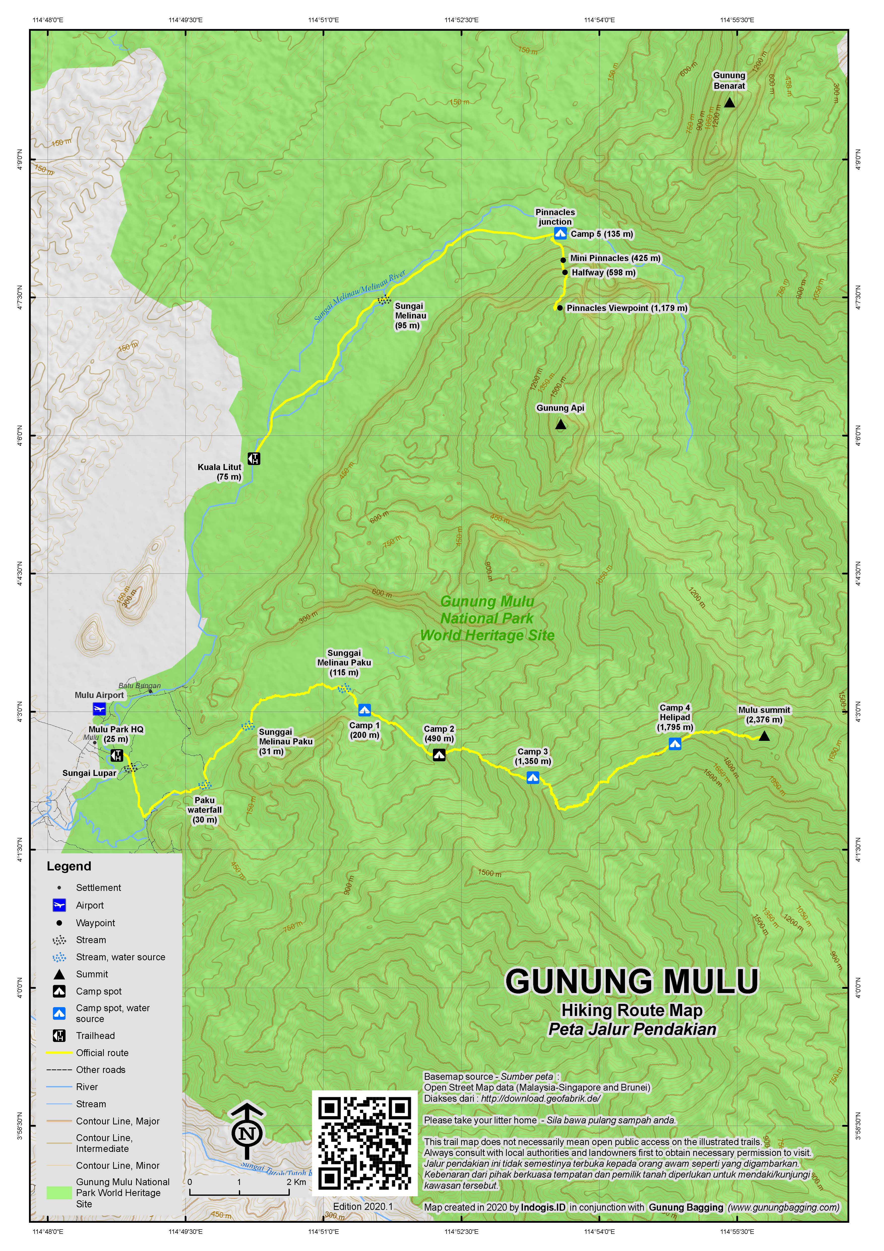
This mountain is the highest peak in the Gunung Mulu National Park which was declared a Unesco World Heritage site in 2005. Several attempts were made to reach the summit in the 19th century, notably by Spenser St John and Charles Hose. The first person to reach the summit was a rhino hunter named Tama Nilong who ‘discovered’ the south-west ridge in the 1920s. In 1932 Tama Nilong led Lord Shackleton and an Oxford University Expedition to the summit and the very same route is still used today.
Mulu Park is perhaps the number one tourist attraction in the entire province of Sarawak, so it may come as some surprise that the summit is reached perhaps only five times per year – usually by avid hikers or scientific researchers.
The usual trek to the summit with park guides takes 4 days and at present (2014) they do not normally allow hikers to attempt to complete the trek in less time than that. This is pretty sensible because the trail is 28km each way, it starts close to sea level, and there are lengthy sections of trail on Day 2 during which you lose elevation gains you have previously made.
Official Park guides are trained in First Aid, carry radios to speak to Park HQ staff on a regular basis and generally speak good English. You may be able to find guides from tour agencies or other operators from outside the park itself but the quality is not guaranteed and your safety may be jeopardised.
Whereas the lower peaks of the Mulu range, including Gunung Api and Gunung Benarat, are limestone, Mulu itself is formed of sandstone. The curiously-named Gunung Api (‘fire mountain’) is presumably so named because of regular fires being seen on its slopes over many decades including, according to Hanbury-Tenison’s “Mulu: The Rain Forest”, in 1968.
Given the other, more popular activities within the Park, it is recommended that you stay at least an extra day or two. The itinerary below assumes that you simply fly in the day before starting the hike and fly out the morning after getting back to Park HQ, thereby being the shortest itinerary under normal circumstances.
Day 0 – Arrive at Mulu National Park (usually by plane from Miri or Kuching). See below for ‘Getting There’ details.
Day 1 – Park HQ to Camp 3.
Day 1 is generally agreed by park staff, guides and the few that have actually climbed to the summit to be the toughest of all the four days so a good night’s sleep the night before is essential.
Assuming you are staying in the Park, you will be having breakfast at the restaurant, which overlooks the Melinau river, from 7.30am. When you checked in previously you should have been given a breakfast voucher for you to use when selecting which choice you would like from the menu. Remember at this stage to buy gas canisters from the shop next to the restaurant for your cooking over the next three nights and four days. It is recommended that you take 1 canister per person per day and although you may well not use all of them it is better to take more than not enough. Canisters cost 13 Ringgit from the shop (2014). You can also buy any last minute snacks, including a packed lunch, from the restaurant and shop but the prices are higher than you would pay normally and the options limited. Your guide should bring plates, cutlery and the actual cooking stove with him but best double-check just to be sure. Any heavy items you have with you that you do not need on the hike can be left with security near the entrance to Park HQ.
The elevation of Park HQ is around just 25m, so you have a hot and humid day ahead of you as you climb to Camp 3 at 1,350m. The first 30 minutes is along the raised wooden walkway as it heads south-east and then south from Park HQ. Just 5 minutes into the trek the walkway crosses over the Sungai Lupar (Lupar River). After 30 minutes you take a signposted left turn down off the walkway. Another 30 minutes and you will have reach Paku Waterfall (on the right side of the trail) which is an important junction (for those doing the ‘Paku circuit’ trek’) and is a good place to stop for a short break.
There are several crossings of the Sunggai Melinau Paku and after another 30 minutes you will be wading through a wide section of the river that is usually only 1 foot deep but could easily cause problems after heavy rain. If possible, consider wearing a lighter, smaller set of shoes (ones that you don’t mind getting wet) as far as Camp 1 before changing into your proper, dry hiking boots. By this stage you are already past halfway to Camp 1.
A deeper, narrow river crossing (at 115m elevation) is required about 45 minutes later. This is likely to be 2 or 3 feet deep even in dry times. Another 20 minutes and you will be at Camp 1 (approximately 200m) – that’s less than 3 hours in total from Park HQ. Camp 1 is the obvious lunch stop (for eating your packed lunch from the restaurant) and it is possible you will be other trekkers or scientific researchers here. Like Camps 3 and 4, Camp 1 has space to sleep around 15 people and has a basic toilet and food preparation area.
From outside Camp 1, if you look up you will see the top of a peak several hundred metres above you on the other side of the river. Apparently this peak, which we do not presently have a name for, was on fire in mid-2014 and required helicopter assistance to prevent its spread.
This is the last river – further up the mountain at Camps 3 and 4 rainwater is collected in tanks whhich you then have to boil before using.
After this point, the trail starts to finally lead you upwards rather than remaining down near sea level. Camp 2 (490m) is reached after 90 minutes from Camp 1. Don’t be fooled by the name, however, as there is little here except a flat area where you could pitch a small tent. There is a small stream down to the right of the trail that could be used in an emergency but don’t count on it during the drier months.
By this time you will have noticed lots of red and white markers along the trail. Most of these are on small metal plates but one or two are spray-painted on trees. This is helpful but in actual fact the trail is pretty clear throughout. There is also a sign near Camp 2 which lets you know that you have so far hiked 7km of the total 24km to the summit. It’s still a long way to go. Look out for sun bear markings on trees in this area (ask your guide to point any scratch markings out).
Depending on your speed it will take you another 3 or 4 hours from Camp 2 to Camp 3 (1,350m) and if it rains you are likely to encounter many leeches during this section. The temperature at Camp 3 is delightful for most Westerners but your local guide might find it a little chilly at night. Just above the impressive hut on the right side is a flat area that was presumably used as a helipad when the shelter was originally constructed. It’s a nice place to watch the sky change colour at dusk but you won’t get any panoramic views.
Tall hikers might be advised to take care in the cooking area as there is a beam that is at the perfect height for bashing one’s head on. Before going to bed, make sure you have hung your food up on the nails. Rats will probably visit at night and are likely to go through bags left on the floor, especially if there is any food in them.
Day 2 – Camp 3 to Camp 4. Sometimes to summit depending on weather and hiking speed.
This is another demanding day but significantly shorter than Day 1. Given what has been written about rats above, it is wise to boil your water this morning rather than the previous night just incase of contamination by rat urine. Not long after setting off you will start to be rewarded with some rather good views towards the shapely peak of Gunung Api (which has an elevation of 1,710m). There are several steep sections of trail here as you ascend through moss forest and up slippery rock. Some parts are steep enough to have had ropes attached to make things a little easier.
From an elevation of around 1650m you will start to spot a few small pitcher plant specimens – Nepenthes Tentaculata. These increase in number as you get higher up the mountain and are larger specimens of Nepenthes Lowii and Nepenthes Muluensis. The views back to steep cliffs near park HQ and the airport runway beyond are impressive.
The trail begins to flatten out to what feels like a flattish ridge. In actual fact you find yourself descending more than ascending over the next couple of hours, clambering over muddy logs and making slow progress. Tall hikers or those with large backpacks will struggle on this section. However, there are more good views on the left of Gunung Api and neighbouring Gunung Benarat (1,615m elevation) between which lies the Melinau gorge. A couple of mud wallows next to the trail look likely to have been ideal spots for rhinos (‘badak’) to have lived many decades ago. Sadly, it appears that there are now none left in Sarawak.
Finally you will be delighted to have made it to Camp 4 (1,795m). It should have taken you between 4 and 5 hours to get up here from Camp 3 so probably still early afternoon. You are now about 1.8km (in a straight line) from the summit of Mount Mulu.
Depending on how you and the rest of your team feel, and after making an assessment of the weather, you could possibly continue on to the summit today, before descending again by nightfall and making your Days 3 and 4 significantly shorter. Most hikers will be happy to have an afternoon rest and watch the butterflies around the hut. Indeed, the chances of clear views from the summit are usually greater during the morning than in the late afternoon so it may be wise for that reason not to summit on Day 2 (but it does all depend on various factors you will have to discuss).
There are quite a few harmless yet persistent bees around Camp 4 and these bees seem to especially like the sweat of Westerners. Don’t be surprised if your socks are covered in bees just minutes after you take them off! Best wash yourself well here so that they aren’t too attracted to you.
You will also notice a bit of grafitti inside the hut by previous hikers and possibly an old snake skin or two in the roof beams. Apparently during rainfall some of the snakes that live up in this part of the forest may enter the building. It makes sense to check first and block any holes in the floor boards with your bags. Alas you won’t be able to block with wide doorway itself but the snakes are not likely to come looking for trouble during the night. There are also squirrels who night come looking for food so, once again, keep your food bags tied up to nails if possible.
Just two minutes further up the trail from Camp 4 is an excellent open area originally used as a helipad during the construction of the hut. This is by far the best viewpoint on the trail so far and therefore a great place for photographs, especially at sunset. You can also be happy in the knowledge that some of your gear will not need to be lugged right the way to the top of Mulu the following morning and therefore you will be travelling lighter beyond Camp 4.
Day 3 – Camp 4 to summit and back down to Camp 3. Sometimes down to Camp 1 if summited on Day 2.
Listen out for gibbons lower down in the forest at breakfast time. The sound is wonderful. From Camp 4, the trail gets near-vertical in places with several roped sections and at one point a ladder to make aid your ascent. After an hour, at around 2065m there is an excellent view to the right of the trail and from here you will spot the pitcher plants Nepenthes Muluensis and Nepenthes Lowii. The former was originally thought to be endemic to Gunung Mulu but has since been found on other mountains in Sarawak. This is a likely spot to hear, or even better see, the magnificent hornbills.
Do be careful in this area as there are many frogs (you will of course hear them) and these frogs are what the Rhabdophis murudensis (Fire-Lipped Keelback) snakes feed on. We saw four keelbacks on the way back down from the summit and it is not known just how serious a bite is as little research has been done and few bites have been recorded. To be on the safe side, assume that a bite could be very serious indeed. Despite the daily radio contact with Park HQ this is a very, very remote area and the last place you want to have a medical emergency to deal with. Therefore walking sticks might be a good idea here. These snakes are encountered in mountaineous areas in both Sarawak and Sabah and it gets its name from Mount Murud where it was first discovered.
You should have reached the summit in about 2 and a half hours from Camp 4. If you are lucky, you will have a wonderful panorama to enjoy and photograph including Gunungs Api, Benarat and perhaps the more northerly Gunung Buda (963m). If you are like most hikers, you will probably catch a few glimpses of distant peaks through the swirling clouds. The summit has a couple of plaques including a memorial to the grandson of Tama Nilong and a Conquering G12 Expedition from April 2009. There is also an antennae for radio signal use across the entire mountain range. Once again, look out for the keelbacks as they slither around in search of mountain frogs.
It should take about 2 hours to descend back to Camp 4 for lunch before the tough work of getting back down to Camp 3. It may only be 3 hours or so back down from Camp 4 to Camp 3 but it could feel a lot longer as you ascend for a considerable proportion of your ‘descent’. If you summited the previous day then presumably you will either have reached Camp 3 by noon and had a relaxing afternoon or else continued down to the hot and humid Camp 1.
Day 4 – Back to Park HQ.
From Camp3 back down to Camp 1 should take around 3 or 3 and a half hours depending on your speed. Camp 1 is the obvious place for a lunch break, but you and your guide may been keen to get back to ‘civilization’ to have a proper shower, change into dry clothes and enjoy a more interesting meal at the restaurant after 3 nights in the forest. It’s up to you to decide on this. Fast hikers can reach Park HQ in about 2 and a half hours from Camp 1 – but remember than you have a couple of river crossings to negotiate.
Day 5 – If you have been staying within the Park, for example at the hostel, check out on the morning of departure is by 10am.
Bagging information by Dan Quinn (hiked September 2014, written October 2014).
This hike was part of a 2014 expedition project ‘Making Tracks: Researching the Mountains of Malaysia and Indonesia’ which was supported by the Royal Geographical Society (with IBG) with a Neville Shulman Challenge Award.
The much more popular Mulu Pinnacles trail starts at Kuala Litut (75m) which is several kilometres further north and accessed by boat from Park HQ, and mostly follows the course of the Melinau River to Camp 5 (135m) which has simple accommodation and is where most trekkers spend the night before the true ascent begins via Mini Pinnacles (425m), Halfway (598m) and finally the fantastic viewpoint itself (1,179m).
For further information on the history of the park, read ‘Mulu: The Rainforest’ by Robin Hanbury-Tenison.
Trail Map
For a high quality PDF version of this and other trail maps, please download from our Trail Maps page.
Practicalities
- Getting there: For Malaysian domestic flights and flights within Southeast Asia, for example to Kota Kinabalu or Kuching, we recommend Baolau. The Park is best accessed by plane as there are daily flights from the coastal city of Miri and several flights per week from Kuching. It is possible to travel overland but this will take at least one full day from Miri. Flights are very affordable at present (2014).
- Guides and GPS Tracks: Want a PDF version for your phone? Looking for a guide? Need GPS tracks and waypoints? Gunung Mulu information pack can be downloaded here.
- Trip planning assistance: Would you like Gunung Bagging to personally help you in arranging your whole trip? Please contact us here.
- Permits: You need to book in advance, especially during June-September when the Park is full with tourists. A booking deposit of 500 Ringgit needs to be made to confirm the reservation in advance. A maximum of 15 people (including guides and porters) are allowed to stay in each of the huts because of the size of the huts and also in order to minimise the impact on the surrounding vegetation. The cost of the hike (including one guide, hut accommodation and cooking equipment) is 475 Ringgit based on a minimum of 3 participants. If there is only one hiker it will cost 1425 Ringgit. Cost of a porter varies from 300 Ringgit (75 per day) to 400 Ringgit (100 per day) (2014). Confirm the price in advance on more than one occasion (i.e with Park staff and with the porter). If taking a porter you will need to pay an additional 45 Ringgit to the park office for the porter staying in the mountain huts. Cashback limit is set at 300 Ringgit per day and there is a 2% charge. Best bring enough cash with you to what is a remote area.
- Water sources: The last reliable natural source of water is at Camp 1 although rainwater tanks are in operation at Camps 3 and 4 for which you will need to boil the water first before using it.
- We recommend Safety Wing as travel insurance for overseas travellers and tourists hiking up to elevations not exceeding 4500 metres.
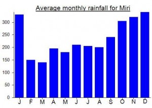
Local Average Monthly Rainfall (mm):
Location
Click on the blue arrow ![]() (top right) to see your current location on the map
(top right) to see your current location on the map
In his book ‘Mulu: The Rainforest’, Hanbury-Tenison writes the following on the pinnacles. “Probably the most spectacular spot in the park was about 3000 feet above the gorge on Gunung Api where a small temporary camp overlooked the famous Pinnacles which we adopted as the Mulu symbol. Geomorphologists became very excited by these dramatic needles up to 150 feet high, sculpted and grooved for fifteen million years since the whole limestone massif rose from the ocean where it formed from the remants of sea creatures. No one knows exactly how they came about but they are unique in size and shape with edges as sharp as knives.”
Spencer St John, who most likely thought Kinabalu’s St John’s Peak (later named after him) was the highest despite being lower than Low’s Peak, made some early attempts on Mulu. He failed in 1857, and tried again with Hugh Low the following year, only to find themselves on the limestone Gunung Benarat rather than the sandstone Gunung Mulu. Later in 1858 he made an expedition to the edge of the Kelabit Highlands but was not lucky with the weather however and did not get a proper view of Batu Lawi. He did make a decent map and estimated Murud’s height to be 8000ft which is only 50ft off today’s official elevation.
The standard 3-day trip to Mulu Pinnacles will be happening with Gunung Bagging in early July 2024. Places very limited. Please leave a comment and I will send futher details. Dan
Dear Dan,
Thank you very much for your descriptive information on Mount Mulu. Yes, we had done the hike, your information still valid at Year 2017!
Mulu summit was the first target on my series of planned hikes in Sarawak. I flew in to Mulu from Kuching – a lovely flight but as expected you only need to look out of the window when flying over much of Sarawak to see the devastation that logging and palm oil industries are having on the environment. Thankfully, Mulu is a different story, with any such activities only going on at the very fringes of the Park area. Mulu airport is tiny, as you might expect, and with the other ten or so tourists I was offered a seat in a car to the Park entrance, crossed the bridge over the river and found Mardhiya, a Malaysian hiker who would be joining the trek and, later, Harvey the guide.
The cafe has an excellent and diverse menu – better than any other National Park cafe I have visited – however prices are a fair bit higher than back in Miri or Kuching due to the remoteness of the location.
I found it tough to get to sleep that night as I was still acclimatising and the fans in the ‘Independent Hostel’ don’t do much to keep the temperature down. We set off ay 9am along with Patrick, our porter. The sounds of the rainforest symphony become increasingly impressive as you get further away from Park HQ and, once you get beyond Camp 1, you will probably not see any other people on the trail.
I was struggling with a large backpack in the incredible humidity and heat to which I was still acclimatising and it can as a huge relief when we reached our place for the night, Camp 3 at just after 5pm. My leech socks did a brilliant job keeping them off my skin – there were plenty about during a rain shower mid-afternoon. The temperature at Camp 3 was delightful and I expected a decent night’s sleep. Unfortunately, the scuttling rats disturbed us a little!
The following morning – a nice, clear morning, we put on our day clothes back on (still soaking wet with sweat from the day before) and left just before 9.30am after preparing some new drinking water from the rainwater tank. For this kind of multi-day trek it is vital to keep your day and night clothes strictly separate so you always have something dry to change into in the evening. Your day clothes will stay moist whatever you do about it, but it doesn’t matter once you get going on the trail again.
It is only now that you begin to get some views of neighbouring peaks in the Mulu range, and this is great reward for what is a steep start to the day. We reached Camp 4 by early afternoon and a rare butterfly landed on my socks. Storm clouds were gathering but the view from the helipad beyond Camp 4 was superb and dramatic. From there, you get an excellent, clear view of the rest of the trail and the summit beyond. It certainly is a steep finale the following morning.
Despite the concerns about snakes entering Camp 4, nothing untoward occurred that night and we were back on the trail by 7.30am hoping to get a reasonable view from the summit. It’s a good job you don’t need to take all your luggage with you for this section as the ascent is often awkward and, without the ropes in place, some sections would be treacherous.
Further up, beyond 2000m elevation or so, you start to see plenty of Nepehtes Muluensis – what was previously thought to be an endemic pitcher. We made it to the top in 2hr 15min but the clouds had already moved in thus limiting our views. The highest reading I got on my GPS was 2385m which is within the margin of error for the official 2376/77m published height for Mulu peak.
The summit ridge is covered in frogs – difficult to see but impossible not to hear croaking near-continuously. Harvey pointed out a snake to us – a snake which feeds on the frogs. It looked to me a bit like the Redneck Keelbacks I had seen in Hong Kong. Five minutes later and Harvey had spotted another one, though he couldn’t tell us the name of it or if it was dangerous. “Consult the guidebook!”
There is some unusual graffiti at the top including ‘Bintulu Ballbreaker’ scrawled across the small radio hut! This is something to do with the Hash House Harriers apparently.
On the descent I spotted two more of the same species of snake sunning themselves on the trail at around 2,065m where you have a open view of lower down forests to the right (left on the way down). With the help of a Facebook snake identification group I later found out that these were indeed part of the Keelback genus – this one is Murudensis or Fire-Lipped Keelback. Take great care not to get bitten.
We spent about eight hours hiking that day and my feet were much in need of drying out when we finally got back down to Camp 3. My favourite meal of the trip was chicken noodles (minus the flavouring) mixed with a small tin of baked beans (both available to buy in the Park HQ shop in small quantities).
The following morning we didn’t meet any leeches whatsoever on the way back down, presumably because it was so dry underfoot. At around an elevation of 380m, I spotted a very bright red tail end of a small snake disappear under leaves – the red colour exactly the same colour as a tree blossom also on the forest floor.
Not far beyond that we met a research assistant from Louisiana State University – David Bernasconi. He had been at Camp 1 for several nights and showed us a particularly impressive – though headless – cicada.
We were keen to get back to Park HQ for a more interesting meal and a decent wash so our stop at Camp 1 was a brief one. The dall and roti in the restaurant tasted particularly good that evening. One disappointment was that our porter requested 400 Ringgit, 100 Ringgit more than the figure given in email correspondence with park staff. I asked park staff about this but they wouldn’t take responsibility for it, simply saying that they were as surprised at the increase as I was. So it seems porters are setting their own charges now, and this can differ from porter to porter, so be sure to check not only with office staff but with the actual porter himself.
This unexpected price increase became something of a theme throughout my project.
I chatted to another researcher, Ryan, about my plans and the mysterious Hose range (Bukit Batu). He showed me a photo of a Hose’s Broadbill, a bird, like the mountain range, named after British zoologist Charles Hose.
With it being Saturday night, many in the park were getting absolutely plastered on local tuak and making quite a racket outside the hostel. Not me – I was exhausted and needed an early night in preparation for my trip to the Kelabit Highlands and Gunung Murud.
Here’s an account of a climb to the summit…
http://outdoorsmalaysia.blogspot.com/2009/04/gunung-mulu-my-3rd-g12-mountain-part-1.html