
Facts
- Elevation: 1,412 m (4,633 ft)
- Prominence: 1,412 m
- Ribu category:
 Kurang Tinggi
 - Province:
 Maluku (Moluccas)
 - Island: Wetar
- Coordinates: -7.6842, 126.5133
- Rating:
 (Bagged it? Be the first to rate it)
 Loading...
 - World Ribus ID: 69090
Bagging It!
Lalaitu is the highest point on the island of Wetar which is the largest of the remote Barat Daya islands. The Bakosurtanal map does not name this peak but has a spot height of 1,427m.
Practicalities
-
- Getting there: Unknown
- Permits: Unknown – take a photocopy of your passport photo page just incase.
- Water sources: Unknown
Local Average Monthly Rainfall (mm): 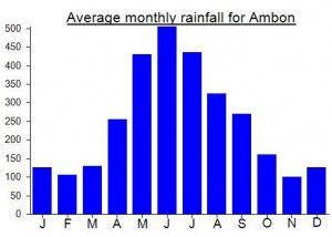
Location
Click on the blue arrow ![]() (top right) to see your current location on the map
(top right) to see your current location on the map
Wetar’s north coast (Lurang) is best accessed by the Cantika Lestari 77B ferry which leaves Ambon every Monday night, arriving in Lurang on Wednesday evening. The south coast (Ilwaki) is only accessible by the various Sabuk Nusantara ferries that call in en route from Ambon or Saumlaki to Kalabahi or Kupang. Lurang and Ilwaki are now connected by a new road that cuts straight through the virgin rainforest. The northern slopes are dominated by towering pinnacle-shaped peaks reminiscent of Jurassic Park. There is a lake in the centre of the island that looks like it belongs in Switzerland. However, the entire area is overrun by dangerous crocodiles, so it is best not to linger. The terrain either side of the road looks wild and untamed, and there are no villages whatsoever in the interior. An ascent of this mountain would not be an easy undertaking.