
Facts
- Elevation: 1,217 m (3,993 ft)
- Prominence: 1,184 m
- Ribu category:
 Kurang Tinggi
 - Region:
 Peninsular Malaysia
 - Malaysian state: Kedah
- Coordinates: 5.7867, 100.4342
- Rating:

 (5 votes) Add your rating
 Loading...
 - Other names: Kedah Peak
- World Ribus ID: 68620
Photos


Bagging It!
Gunung Jerai is a very striking limestone mountain surrounded by flat land and located on Malaysia’s west coast. In ancient times it was used as a navigational aid by traders from overseas and allegedly was once an island called Pulau Serai. It was also previously known as ‘Kedah Peak’ and is normally clearly visible from Penang. The mountain is also allegedly home to the mysterious legendary supernatural creatures known as Orang Bunian.
Gunung Jerai has long been regarded as a religious site and to this day it is common to see local Malays studying the Koran near the top. The forest has been protected since 1953 and the area is now listed as a Geopark as it contains the oldest rock in Peninsular Malaysia. There are several geological and historical sites worth a visit and paragliding is popular from halfway up the mountain. It is also the northernmost Ribu in Peninsular Malaysia.
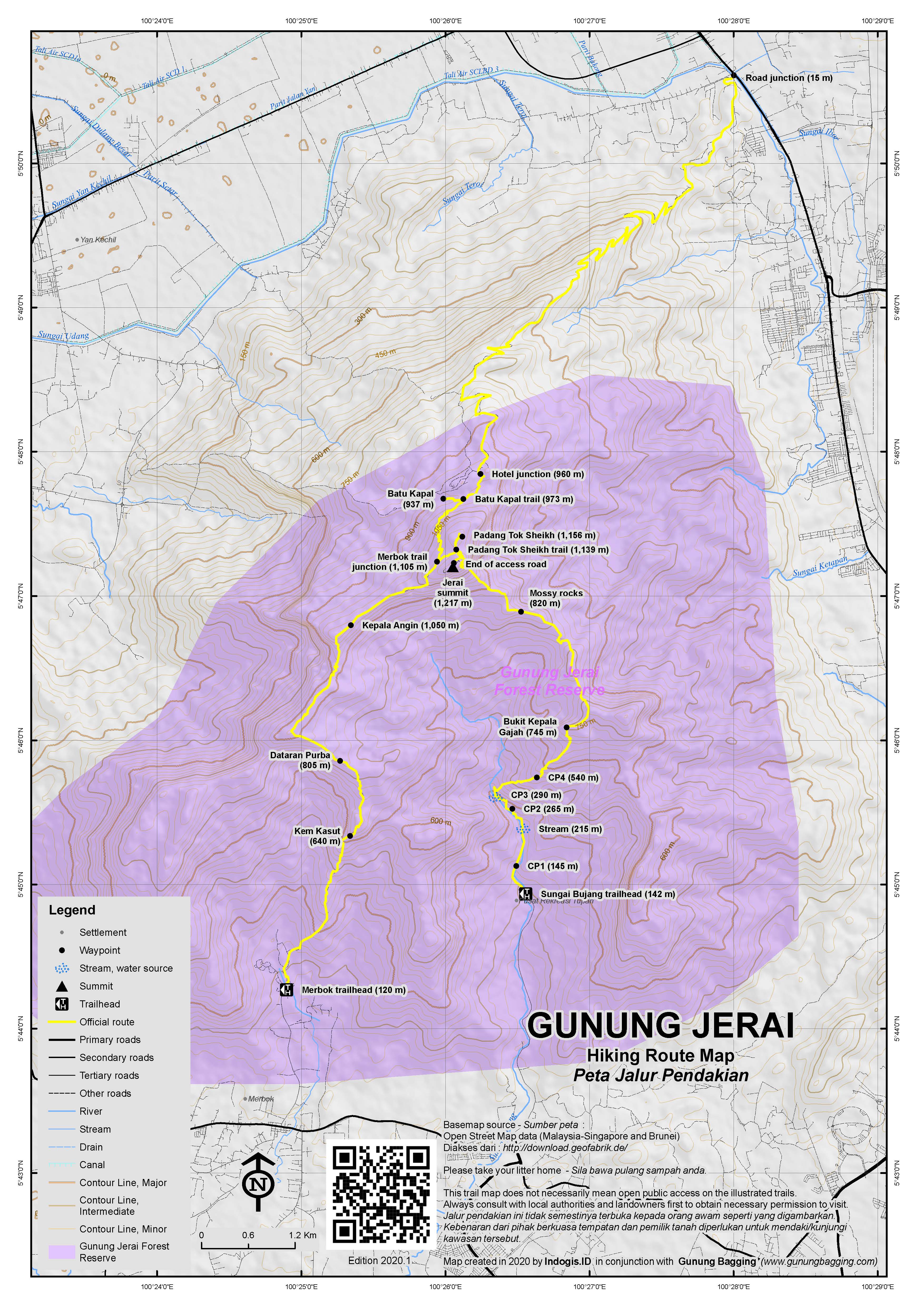
There is actually a road all the way to the top running for 12 kilometres (30 minutes by car) from the north near Gurun. Near the top is a hotel complex (The Regency Jerai Hill Resort at 960m), a Museum of Forestry (near the hotel), a food court, and a telecommunications tower. Most people therefore drive much of the way although keen hikers might like to know that some people trek to the top through forest from the south side at Merbok and Sungai Bujang and from the west side at Yan.
The Yan route starts/ends near the resort and leads up/down via Tangga Kenari. It is clearly signposted just before the hotel. Hiking purists may wish to hike up from Merbok or Sungai Bujang (see info below) and down to Yan (or vice versa).
After the resort junction, the road gets narrower and dips down past a few roadside stalls before ascending slightly to a little space for two small cars at the junction (973m) for Batu Kapal (‘Boat Rock’). Batu Kapal is a rock outcrop that resembles the wall or floor of a boat and is worth a 10-minute detour on the way back. If you want to do some kind of walk then best leave your vehicle here and spend an hour or two strolling further up and back down again.
Above 1,000 metres elevation you will see a few pitcher plants growing at the side of the road. It is also around here that you will be granted your first panoramas of the western coastline and the large Bunting island which is connected to the mainland by a bridge.In clear weather you should be able to see all the way to the Langkawi islands behind Pulau Bunting.
A little further up there is a prominent trail sign on the right and this is the junction (1,105m) for the hiking trail leading up from the Archaeological Museum (120m), Lembah Bujang (Bujang Valley) in Merbok to the south of the mountain. This trail passes via Kem Kasut (640m), Dataran Purba (805m) and Kepala Angin (1,050m), both of which have good views down to the coast.
A second route up from the south starts near Tupah water treatment plant at Sungai Bujang (142m) just 3 kilometres east of the Museum trail. It leads via CP1 (Checkpoint 1 – 145m), a stream (215m), CP2 (265m), CP3 (290m) where there is another stream and water source, CP4 (540m) and Bukit Kepala Gajah (745m). From here the trail follows the ridge via some mossy rocks (820m) before ascending steeply to the east of the highest point to near where the access road finishes.
It would obviously be great to trek down one of these ways but for most visitors who have driven a car up it will not really be practical without considerable planning. Apparently, fit hikers can be up in 4-5 hours and back down in 3-4. The Merbok area is fascinating, with numerous Hindu-Buddhist artefacts having been discovered in the Bujang Valley – hence the existence of the Archaeology Museum. Watch out for leeches and scorpions on these routes (in addition to the many lovely pitcher plants).
A little further on on the left is another small parking space which is the junction (1,139m) for Padang Tok Sheikh (1,156m). This is an important geological feature as it is made of the oldest rock in all of Peninsular Malaysia. It is also claimed that the first Islamic call to prayer in Malaysia was made at Padang Tok Sheik back in the 12th century. The site includes an Islamic tower monument and a small camping area and is just 2 or 3 minutes from the road junction. You may see evidence of wild pigs (‘babi hutan’) in the area.
The views to the south-east from the edge of the cliff near the Islamic monument are great and Gunung Bintang would definitely be visible in clear weather or early in the morning.
Further up, the main access road ends at around 1,175m with warning signs and a gate with a security guard on site and an instruction not to take photographs or attempt to enter the telecommunications compound. The views to the west coast and the Kedah plains are quite impressive here with a lovely little island out in the ocean below which appears to be named either Pulau Telor or Pulau Songsong. The highest point of Gunung Jerai is very close indeed but unfortunately not possible to reach at present.
Bagging information by Dan Quinn (December 2018)
Trail Map
For a high quality PDF version of this and other trail maps, please download from our Trail Maps page.
Practicalities
- Getting there: For Malaysian domestic flights and flights within Southeast Asia, for example to Kuala Lumpur, we recommend Baolau. Penang is the nearest large airport, but Alor Setar is not far away either. Gurun is the closest train station.
- Guides and GPS Tracks: Want a PDF version for your phone? Looking for a guide? Need GPS tracks and waypoints? Gunung Jerai information pack can be downloaded here.
- Trip planning assistance: Would you like Gunung Bagging to personally help you in arranging your whole trip? Please contact us here.
- Permits: Not required.
- Water sources: On the higher slopes there is usually some water in the channel by the side of the road for emergency use but best take sufficient supplies with you or buy at the stalls near the hotel complex. Available as far as Checkpoint 3 (290m) on the Sungai Bujang trail.
- We recommend Safety Wing as travel insurance for overseas travellers and tourists hiking up to elevations not exceeding 4500 metres.
Local Average Monthly Rainfall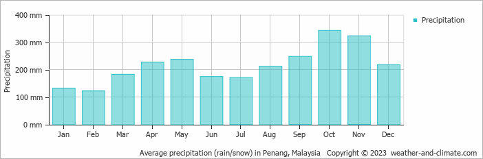
Location
Click on the blue arrow ![]() (top right) to see your current location on the map
(top right) to see your current location on the map
John Briggs, in his ‘Mountains of Malaysia’ book from the late 1980s, writes that ‘in 1884 a stone and brick construction was found on the summit. It was hidden under a metre-thick layer of peat and revealed by accident when the peat caught fire. The origins of the building are a mystery. They were at least 1,000 years old and unknown to the local people living nearby. They are the only ancient ruins ever found on a mountain top in Malaysia. Unfortunately, the ruins were destroyed in the construction of the summit survey beacon and the site is now covered by the radio station’.
After my friends did Gunung Pulai, we drove over to Gunung Jerai, making it to the top just after sunset. The security guard at the top gate was bemused as ever as I said ‘good evening’ to him and we took a few photos of the ocean down below. A real shame it is not possible to bag the highest point, but that’s just the way it is. A great viewpoint for sure.
Hi sir,
Can you share the GPX file of your movement? i tried to find the ship rock trailhead but unbale to do so.
Thanks !
Spent last weekend exploring both Jerai and Western Hill (the highest hill in Penang). Pretty easy to do from Jakarta as there are both AirAsia and Citilink direct flights as convenient times. This was made even easier by a friendly Penang resident, Kevin, being keen on returning to Jerai.
It took around 90 minutes to get to the foot of the mountain from Penang airport, with some great views of the mountain from Penang bridge. It is well signposted in Gurun and there is a food court both at the junction car park and also 12km further up the mountain road before the hotel.
I had already heard that the true summit was impossible to reach due to it being a telecommunications / military compound (see also Western Hill, Gunung Serapi, and others) but what with a road to the top and sites of historical interest it was of great interest regardless.
We left the car at the Ship Rock trailhead, where there was a Pig Tailed Macaque searching around for food. Lovely creature – we don’t have these in Java. According to Wikipedia they have been trained in Thailand for 400 years to harvest coconuts.
From the car it took us around 45 minutes to leisurely wander up to the highest accessible point – the gate full of warning signs. There was someone in a security box just beyond the gate watching tv, but I don’t think they mind folk taking pictures of the coastline here as it is a particularly fine view, especially of the flat paddy fields below and the islands.
We visited Padang Tok Sheikh on the way back to the car – another great viewpoint of the other side of the mountain. There were 3 or 4 guys in Islamic gear studying the Koran at the base of the Islamic monument and at first they seemed a bit shocked to see me walk over. But when they saw my batik shirt and heard me talking Indonesian they warmed up considerably. Definitely a site of religious pilgrimage so do be aware.
Down at the ship rock it was a similar story, with a Muslim chap dressed in white at the pondok looking a bit confused, and dare I say it out of it, as if he had been ingesting narcotics of some kind. Perhaps he was just receiving religious revelations or indeed just shocked to see a couple of western guys wandering about.
Other than that, the mountain was reasonably quiet except for a few visitors lower down near the hotel.
We were back in Penang by late afternoon so went and had a well-earned beer on Love Lane. Jerai is visible from the beach at Batu Ferringhi where I stayed but the weather was a little cloudy at dusk.