
Facts
- Elevation: 282 m (925 ft)
- Prominence: 282 m
- Peak category:
 Spesial
 - Province:
 Maluku (Moluccas)
 - Coordinates: -6.6352, 126.6607
- Rating:
 (Bagged it? Be the first to rate it)
 Loading...
 - Eruptions: 1512, 1699
Bagging It!
Gunungapi Wetar volcano forms an isolated island in the Banda Sea north of Wetar Island. The small circular island reaches only 282 m above the sea surface but is the summit of a massive stratovolcano that towers 5000 m above the sea floor. The central crater contains a small cone. Three large landslide scarps, the largest of which forms a prominent embayment on the NE coast, cut the flanks of the volcano. The youngest lava flow descended the SW flank to the coast. Explosive eruptions in 1512 and 1699 mark the only known historical activity of Gunungapi Wetar (Smithsonian).
Practicalities
-
- Getting there: Unknown
- Permits: Unknown – take a photocopy of your passport photo page just incase.
- Water sources: Unknown
Local Average Monthly Rainfall (mm): 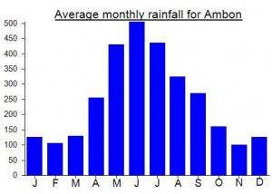
Location
Click on the blue arrow ![]() (top right) to see your current location on the map
(top right) to see your current location on the map