
Facts
- Elevation: 2,064 m (6,772 ft)
- Prominence: 425 m
- Peak category:
 Spesial
 - Province:
 Jawa Barat (West Java)
 - Coordinates: -6.7742, 107.5557
- Rating:


 (8 votes) Add your rating
 Loading...
Photos


Bagging It!
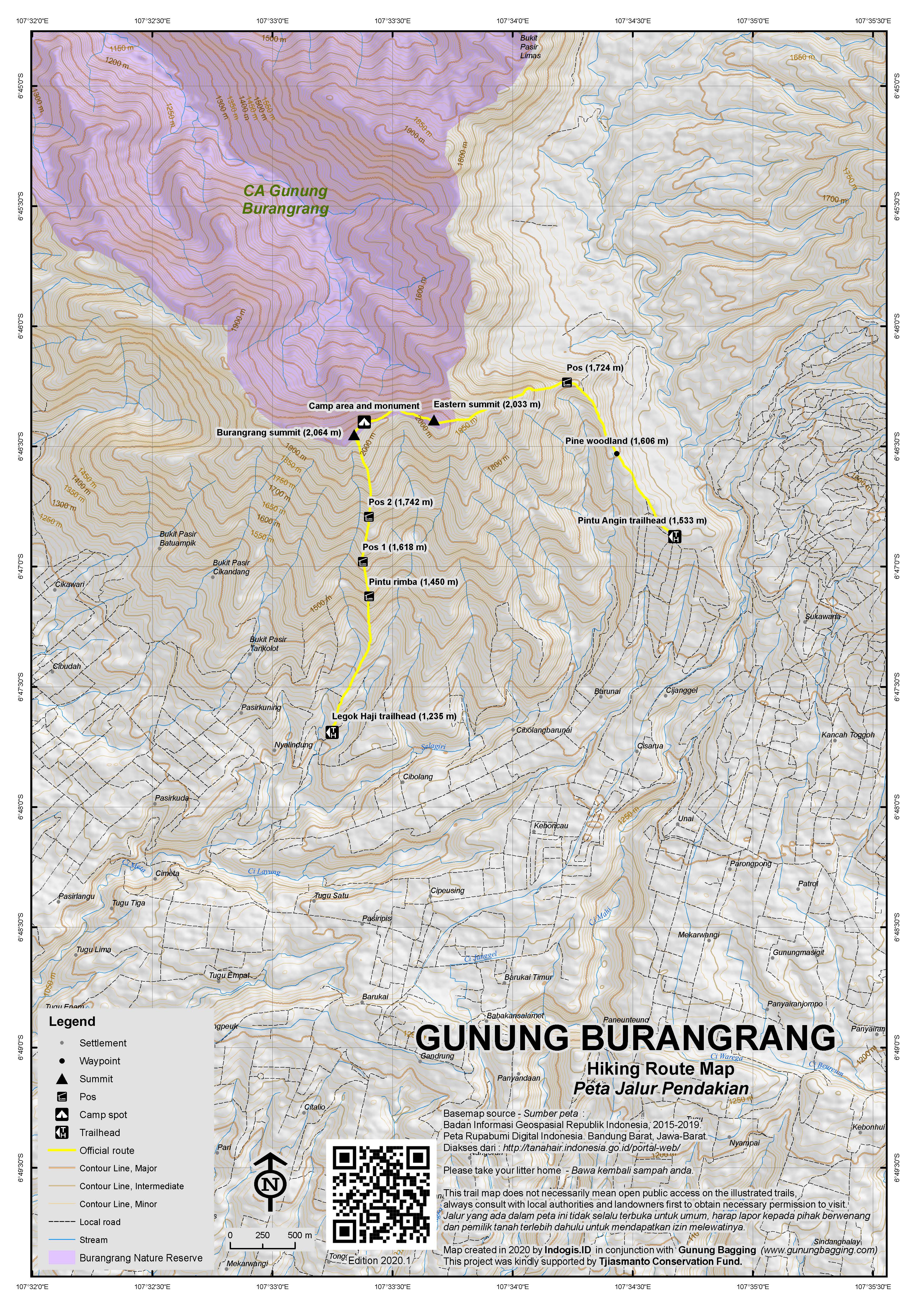
Burangrang is the westernmost of the 2000-metre high peaks north of Bandung. Along with Tangkuban Parahu and Bukittunggul it is the remnants of the ancient Mount Sunda. Burangrang makes an excellent ridge walk and is a very popular mountain given its proximity to the city of Bandung. It is also rather challenging in places. There are two main routes up onto the ridge – from the east at the col known as Pintu Angin and from the south at the tiny village of Legok Haji. At over 1,500m above sea level, Pintu Angin separates Burangrang from neighbouring Tangkuban Parahu. There is a stony track leading from Parompong all the way up to the col and beyond to the beautiful lake of Situ Lembang. Unfortunately this area is used for military exercises and is often closed. Even hikers wishing to climb Burangrang are now asked to request ‘permission’ from Indonesia Special Forces in advance. Therefore it is much better to climb from the south at Legok Haji and either descend the same way or simply claim ignorance at the small building when you descend to Pintu Angin!
To get to Legok Haji (1,235m), it is best to take an ojek for the short 3 or 4 km trip from Cisarua. The trail starts at the end of the village track and leads up to the right past some graves and up along a delightful grassy ridge offering a fabulous panorama in all directions. The friendly villagers will point you in the direction if you are lost. After less than an hour you will enter the forest (at about 1,450m) and encounter a few steep, muddy sections of trail where the use of your hands is required. There are a couple of flattish areas suitable for camping (Pos 1 – 1,618m, and Pos 2 – 1,742m) but there isn’t much point considering this trail leads directly up to the highest point of the Burangrang ridge and you can be at the top in 2-3 hours total. Just before the summit is an area of recent landslide. Take care both here and on the summit ridge itself as the drops are often several hundred metres!
Finally you will reach the grassy top crowned with one of the largest summit pillars in Indonesia. The panorama is superb – Kawah Sunda Purba (the ancient Mount Sunda crater) to the north, the lake of Situ Lembang visible to the Northeast and the outskirts of the city of Bandung to the south. There is enough space for one tent next to the summit pillar but a better place is just three minutes walk east along the ridge just before a small memorial, presumably to a local climber. This second spot is large enough for 2 or 3 tents and offers even better views of Situ Lembang lake.
You can return to Legok Haji in two hours or if you’re feeling adventurous you can explore the eastern part of Burangrang ridge and descend to Pintu Angin. However do be aware that getting an ojek from Pintu Angin is pretty much impossible and you would have to walk for another hour to the ojek post at the end of the stony track in Parompong. After the small memorial stone the ridge descends steeply and suddenly and there is even a short section where you can use a thin rope to help you. The views here are fabulous – a sheer drop on the northern side offering excellent views of other minor peaks that are part of the same mountain range. Beyond the rope section the trail ascends to Burangrang’s eastern top (approx. 2,033m), although the main trail actually circumnavigates it.
After the eastern top, the trail is steep and muddy as you head down via numerous minor tops to eventually find yourself in pine woodland (1,606m) at the base of the mountain. From here head out to the stony track at Pintu Angin (1,533m) and walk down towards Parompong where you will be able to find an ojek back into Bandung.
Bagging information by Daniel Quinn (November 2011)
Trail Map
For a high quality PDF version of this and other trail maps, please download from our Trail Maps page.
Practicalities
- Getting there: For domestic flights from or to West Java, such as the airport in Bandung, we recommend Baolau. For Legok Haji, head from Bandung to Cimahi and turn up the hillside towards Cisarua. From Cisarua take an ojek or drive along the final 4km of village tracks to Legok Haji (difficult to find parking spaces here). For Pintu Angin, drive from Bandung to Parompong and the up the stony track which leads all the way to Situ Lembang lake. Angkots are also available to both Cisarua and Parompong.
- Guides and GPS Tracks: Want a PDF version for your phone? Looking for a guide? Need GPS tracks and waypoints? Gunung Burangrang information pack can be downloaded here.
- Trip planning assistance: Would you like Gunung Bagging to personally help you in arranging your whole trip? Please contact us here.
- Permits: You are supposed to request permission in advance if climbing from Pintu Angin. No permits or official permission required if you hike from Legok Haji so it’s a much better starting point.
- Water sources: No water sources found – take enough with you.
- Accommodation: Try the Booking.com map above or use this link to search for suitable hotels, homestays, resorts and apartments for your trip.
- We recommend Safety Wing as travel insurance for overseas travellers and tourists hiking up to elevations not exceeding 4500 metres.
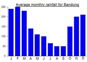
Local Average Monthly Rainfall (mm):
Location
Click on the blue arrow ![]() (top right) to see your current location on the map
(top right) to see your current location on the map
Climbed Burangrang on Sunday 26.07.20 from Legok Haji.
Having heard stories of several un-successful ascents from the Pintu Aingin trailhead from the North-East which passes through the Indonesian Special Forces military training grounds.
Legok Haji (1,235m) seems like a very well established trail basecamp and when we arrived at 245pm the camping area was buzzing with activity of people in no rush to go home having recently returned from the summit. We set off at 3pm for the summit and experienced a very well marked trail which got very steep from Pos 2 (1,742m) to the summit. As we summited we were pleased to see the sky clearing and we enjoyed glorious views towards Mount Sunda and its Crater Lake Situ Lembang – North-East and also Tangkuban Perahu to the East. It took us just under 2 hours to summit at a reasonable pace.
For those looking for adventure returning via Pintu Aingin would be fun, as you can clearly see several ridges with steep drops as you head east from the summit on that trail. As we had driven in our own car we returned down towards Legok Haji and were back at the basecamp in just over an hour just after dark.
I would suggest stay clear of Burangrang on Friday night, Saturday….. as its has clearly become a very popular hike amongst the Bandung hiking community. We climbed on a Sunday afternoon and most groups we encountered were on the way home.
Highly recommended hike, easily accessible from Bandung and you are rewarded with fine views of Mount Sunda.
I know a great guide for the Bandung Gunungs, Pepep feel free to contact me if you would like his contact details.
Hi, thanks for sharing the review. Are u able to share the guide’s contact numbers pls?
Back from a great traverse of Burangrang with Yudi, the young expert on the mountains near Bandung. We set off at about midnight from Legok Haji – a beautiful clear sky and nearly full moon. We were at the summit in just over 2 hours so we had quite a long wait for the dawn to arrive. Luckily there were some friendly students camping at the top so we chatted to them for much of the night. There appeared to be thunderstorms in every direction but luckily Burangrang was spared. Just before sunrise, a lot of low cloud blew past but this had disappeared in less than an hour to reveal a bright blue sky. I was very impressed with the ridge itself – pretty tough in places with huge drops on the northern side. It is a very worthy Spesial peak – watch out for another 4 new ones in the Bandung area to be added later this week.
We descended to Pintu Angin (in about 2 hours) where there was some kind of military exercise going on – a horrid racket ruining the quiet! When we got down to the security post we were told that we shouldn’t have been up there and you need permission and all that crap. Pathetic! Oh well, too late now, we’ve already done it!
I remembering trying to climb this mountain in December 2010 with Java Lava. The chaps at the security post told us it was too slippery and so we weren’t allowed! It is indeed a slippery mountain in places but that isn’t sufficient justification for closing access. Funny how they seem concerned about your welfare when it comes to hiking yet the number of greater dangers in Indonesia on a daily basis is simply overwhelming. So, to avoid all this bureaucratic nonsense, best climb this one from Legok Haji.