
Facts
- Elevation: 786 m (2,579 ft)
- Prominence: 786 m
- Peak category:
 Spesial
 - Province:
 Sulawesi Utara (North Sulawesi)
 - Island: Thulandang
- Coordinates: 2.3450, 125.4392
- Rating:

 (2 votes) Add your rating
 Loading...
 - Other names: Siwoge
Photos


Bagging It!
This is the highest point of the island of Tagulandang (in the Sangihe islands) and is the dormant remains of an old volcano crater rim. In 2017 we were unable to find any information locally about a trail onto the summit ridge although it may be worth asking in Haasi (a short ojek ridge along the coast from the main town of Bahoi) or Bawoleu or Minanga in the inner valley of the island. The name ‘Bukiri Kalongan’ does not seem to be known locally though it is used on the Bakosurtanal map which gives a height of 788m. One old US Army map lists the highest peak as Gunung Siwoge (805m). Cloves, nutmeg and salak are grown on the island and it is a particularly picturesque place. The second-highest peak on Tagulandang is called Gunung Malingge (‘Wuluri Balinge’ on the Bakosurtanal map) and is only a handful of metres lower than Bukiri Kalongan (Bako suggests just 4 metres lower at 784m). It looks like an ancient, inner volcano that is now dormant or possibly extinct. It too is densely vegetated, and despite a good network or roads round the island it remains unclear if there is a trail up to the top. Views from Tagulandang island are especially great when looking south-west to Ruang isand and volcano and north to Siau’s highly-active Karangetang.
Practicalities
-
- Getting there: The Majestic Kawanua Ferry travels daily in both directions (up from Manado, down from Tahuna and Siau). In 2017, a ticket from Manado is Rp175,000 and the journey time is about 2 and a half hours. There is also a larger, slower boat several times a week for Rp100,000.
- Accommodation: In 2017 there are at least three places to stay in town – the Platinum Inn or Claudy Hotel are the best ones.
- Permits: Unlikely to be required – but ask in local villages and inform them of any hiking plans.
- Water sources: Unknown
Local Average Monthly Rainfall (mm): 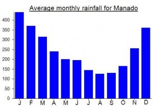
Location
Click on the blue arrow ![]() (top right) to see your current location on the map
(top right) to see your current location on the map
Headed out to Tagulandang last week to see if I could find much info on this and Gunung Malingge. Not a lot to go on, and sadly the ‘roads’ shown on Google Earth leading over the summit ridge of Bukiri Kalongan are complete fiction. However, the road leading up into the hills and close to Malingge is not fiction, and is part of a very picturesque ojek ride round the island (I paid 150,000 for several hours). Take the road up to the transmitter tower beyond the PLN Electric Station, through clove and nutmeg plantations and then over the other side near Malingge before dropping down into the valley known as a good place for Salak fruit, round to the village with mildly warm springs and then out round the grassy coast with excellent views to Karangetang on Siau island, and back round to the main town of Bahoi (great views of Ruang opposite).
Getting to Tagulandang itself is reasonably easy from Manado with daily boats, although sadly it is still not possible to book boat tickets online yet so you need to ‘queue’ up outside a grubby counter near Manado Marina. It would appear there are almost always seats available but I would get there early or book the day before if possible. Boats sometimes call off at Biaro first, and this adds half an hour onto the journey.
Nobody had heard of Bukiri Kalongan but there must be trails leading at least part of the way up the ridge, whether from the outer side or the inner side. The island itself is known on most maps as Thulandang, officially as Tagulandang, and locally as Mandolokang. Very few foreigners visit.
Very friendly island – I recommend Chill Out Cafe – a small place to eat and drink near Platinum Inn.