Facts
- Elevation: 1,428 m (4,685 ft)
- Prominence: 1,320 m
- Ribu category: Kurang Tinggi
- Province: Kalimantan Barat (West Kalimantan)
- Google Earth: kml
- Rating:
- Other names: none
Photos
Bagging It!
‘Onion Mountain’ is probably the most accessible hike of any great significance in West Kalimantan. Despite being less than 1500 metres high, the mountain has a huge amount to offer adventurous hikers including gorgeous rivers, pristine forests home to hornbills, pitcher plants, black orchids and all manner of creepy-crawlies plus stunning, panoramic views from the summit. One of the easier mountains to ‘bag’ in Borneo, Gunung Bawang remains relatively unknown to hikers outside of the province.
There are two trailheads – one at Desa Madi near Bengkayang and one at the village of Sungai Betung down a rough track which runs alongside a river and below the mountain itself. The latter is slightly more accessible and shorter – and so more frequently used. A couple of warungs selling snacks and drinks marks the junction – a few kilometres before Bengkayang – where you must turn left down a track to Sungai Betung village. Allow one hour and take motorbikes because there is a river which is often too deep to ford in four-wheel vehicles (so you instead take your motorbikes over the pleasant bridge).
The village head lives opposite the small pink and blue church and he is the man to register with (and pay just a few thousand rupiah). If you don’t already have a guide (which is essential) then he should be able to find someone to accompany you. The village is at an elevation of about 80m and those with motorbikes can continue for another couple of kilometres up the hillside directly behind the village head’s house beyond an entrance sign and large ceramic vase (165m) up to a cluster of abandoned and dilapidated buildings at the Sei Sansak river (218m) which used to be for producing electricity but are now regarded by hikers as the ‘basecamp’. They are padlocked but you can still find some limited shelter should it rain and there are plenty of flat areas ideal for camping should you wish. The river itself (250m) is gorgeous and perfect for a wash or swim both before and after the hike. Bear in mind that in the rainy season you may have a little difficulty getting your motorbikes back down the muddy trail which is steep in places.
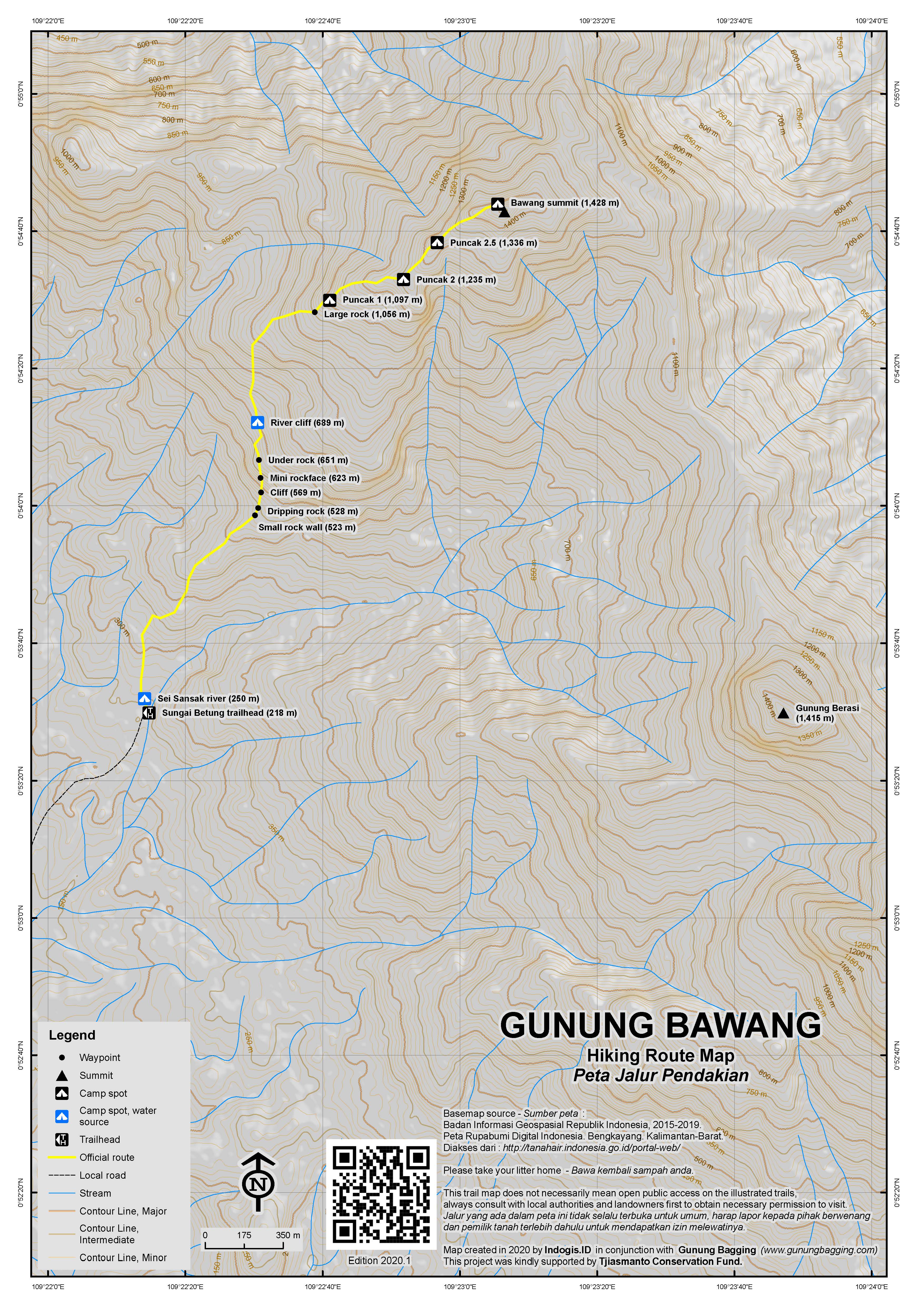
The hike proper begins behind the basecamp buildings. First you must cross the river itself (prepare to get your feet wet on this hike!) before ascending up to the right. Little black plastic bits of string tied to trees mark the route every hundred metres or less but even so it is easy to get lost here even with a GPS. There are lots of birds to be heard and occasionally seen in the forest and you should be able to hear the hornbills at an elevation of around 500m. At about 523m is a rock which looks at first like a man-made wall. It is the first of many rocks and cliffs in the middle section of the trail, some of which require careful scrambling and the use of all four limbs to clamber up near-vertical walls and roots. At 569m is a minor cliff-face with water often dripping from it.
A larger cliff is at around 623m before you reach an absolutely stunning little spot in the middle of the forest where water comes cascading down cliff faces (689m). This would make a wonderful place to camp for those not limited by time schedules. There is even a flat area where you could pitch 3 or 4 tents right next to the stream. From this point on check your boots and legs regularly for leeches (‘pacet’) as there are plenty of them in the higher parts of the forest. The trail continues weaving its way steeply up the side of the mountain, around large boulders now and again – a couple of which are almost cave-like and offer decent shelter from the rain, before reaching the edge of a ridge at 1,097m. This is known as ‘puncak 1’ by local hikers although it is not a proper peak of any sort but it is a reasonable spot to pitch a tent or two.
‘Puncak 2’ (1,235m) is reached after another 20 minutes or so and once again there is space for tents. By this point the vegetation has changed remarkably and there are orchids and moss and occasional pitcher plants. The trail drops down before ascending steeply again. Another spot at 1,336m in the middle of the trail (perhaps you could call it ‘puncak 2.5’) is reached before the views of surrounding mountains and valleys below begins to open up dramatically. The true peak ‘puncak 3’ is delightful and because of the lower vegetation offers stunning views in all directions. There are two cement summit markers and a couple of tiny water pools which are reasonably reliable during the wet season.
The large, prominent peak to the south is Gunung Berasi – the second highest in the range at approximately 1,415m. The Bakosurtanal map lists Bawang as 1,265m and Berasi as 1,224m but both of these figures are considerably lower than the real elevations.
In the distance to the east you may be able to spot Gunung Niut if you are very lucky indeed. Looking back along the ridge to the west you will see the lesser mountains closer to Singkawang, although from this angle the thumb-like Bukit Jempol cannot be seen clearly. In extraordinary conditions you may even see the ocean in the distance.
All together, assuming you walked from the village of Sungai Betung, it should have taken you about 6-8 hours to reach this point – perhaps one of the finest viewpoints on the island of Borneo given how densely-forested most peaks are here. Fit hikers can be back down at Sei Sansak river basecamp in about 4-5 hours for a good splash in the water before heading back out from this remarkable area.
Bagging information by Daniel Quinn (April 2013)
Trail Map

For a high quality PDF version of this and other trail maps, please download from our Trail Maps page.
Local Accommodation
Practicalities
- Getting there: Allow 5 hours from Pontianak – or 2 hours from Singkawang – to Sungai Betung village.
- Guides and GPS Tracks: Want a PDF version for your phone? Looking for a guide? Need GPS tracks and waypoints? Gunung Bawang information pack can be downloaded here.
- Permits: Not required but take a photocopy of your passport photo page just incase.
- Water sources: Sei Sansak River at the basecamp (250m). Lovely cliff-face/river at 700m elevation. Several other dripping rock-faces which cannot be relied upon except in the wet season. Possible couple of tiny pools on the summit ridge during the rainy season.
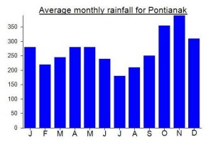
Local Average Monthly Rainfall (mm):

Location
Origins and Meaning
‘Onion Mountain’ in Indonesian. This is apparently because the peak resembles the top of an onion – with layers surrounding the central highest peak.

 (4 votes) Add your rating
terimakasih telah memuat laporan perjalanan ke gunung bawang bengkayang kalimantan barat,semoga perjalanan anda berkesan.
suatu saat saya akan mengunjungi,dan mendaki gunung bawang.
Many thanks to pitcher plant expert Alastair Robinson for identifying the Nepenthes I photographed on this mountain as Nepenthes tentaculata.
Had a fantastic hike up Onion Mountain this past weekend. Many thanks to the lads from Universitas Tanjungpura and friends in Pontianak for sorting out all the logistics. Arrived on Friday night, stayed in Pontianak at Mess Hijas (only Rp90,000 incl hot water) the up early to visit the equator monument (after watching the water in my sink just ‘sink’ down rather than turn clockwise or anticlockwise) and on to Singkawang for lunch.
We then headed inland towards Gunung Bawang passing by a smaller range including Bukit Jempol (thumb hill) and then an area where the Dutch built a small landing strip. I grabbed a Korean Dester beer at a roadside warung up in the hills (imported in Sarawak, brought over the border illegally perhaps???) and I must say it was one of the finest lagers I have ever tasted. The road then dropped before we reached the turning for the village.
We finally arrived at the trailhead at around 1pm, so although it is technically possible to do this hike in a weekend from Jakarta, it is in reality almost impossible. The Sei Sansak river is gorgeous and except for the chainsaw work by a couple of local villagers (for local buildings only, not for ‘capitalists’ apparently) it was an idyllic place to relax.
The trail itself is by no means easy – lots of steep sections where a fall would be disastrous. With large backpacks it can take a long time to negotiate these sections especially given the humidity and low elevation. Luckily there are plenty of water sources, the most beautiful of which is the cascading stream which comes down over near-vertical rock faces at around 700m elevation. Another spot where you really have to take a rest and enjoy the scenery.
Apparently orangutans used to live here but have since left for more remote mountains presumably.
After another couple of hours of hard work we camped at ‘puncak 1’ as some of the hikers were exhausted. A perfect temperature at 1,100m but tons of leeches. I woke up with a couple on my feet and they are itching like crazy now more than 2 days later.
We decided to get up at 4am in order to see the views at first light from the open summit. It turned out to be quite similar to Gunung Besar (Halau halau) in South Kalimantan – thick forest right the way up to the final top which offers 360 degree panorama of hills near and far. Stunning. Lots of butterflies fluttering about too. GPS recorded 1460 so our listing could be an underestimate. Look out for black orchids in the area (‘anggrek hitam’).
We made it back down (leisurely) by nightfall and went for a beers or two in Singkawang which was full of Easter gatherings, having 50% population of Chinese.
A fabulous mountain unknown to most that I would heartily recommend – though from Jakarta you’ll need a long weekend to do it unless you are super-fit and want to rush things. Next plan is Gunung Niut which requires about a week. Thanks once again to Abdi and friends for a great weekend.