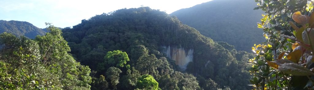
Author name: Dan

Gunung Buntung

Facts Elevation: 1,042 m (3,419 ft) Prominence: 627 m Peak category:  Spesial Province:  Kalimantan Timur (East Kalimantan) Coordinates: 1.6039, 117.4116 Rating: Photos Bagging It! Gunung Buntung is one of the highest peaks in the huge, spectacular Gunung Kulat karst area in East Kalimantan about which very little is known.

Gunung Buntung Read More »

Puruk Sandukui

Facts Elevation: 1,023 m (3,356 ft) Prominence: 772 m Peak category:  Spesial Province:  Kalimantan Tengah (Central Kalimantan) Coordinates: -0.4469, 113.5293 Rating: Photos Bagging It! Puruk Sandukui is incredibly difficult to get to – it takes several  days from the nearest city of Palangkaraya. This may explain why there are so few images of it available online. Apparently,

Puruk Sandukui Read More »

Bukit Batikap

Facts Elevation: 1,580 m (5,184 ft) Prominence: 491 m Peak category:  Spesial Province:  Kalimantan Tengah (Central Kalimantan) Coordinates: 0.2608, 113.4284 Rating: Other names: Betikap Photos Bagging It! Bukit Batikap is one of the northernmost mountains in Central Kalimantan. In 2012, as part of a mapping project with Tumbang Tohan, Heart of Borneo followed three village members to

Bukit Batikap Read More »

Gunung Kerenceng

Gunung Kerenceng is something of a hidden gem, lying so close to Bandung but little-known outside of local West Java hiking clubs. It can easily be climbed as a day hike, taking no more than 2-3 hours up and 2 hours down. The summit area is a tiny equilateral triangle with sides of just 3 metres and is where three narrow mountain ridges meet. Kerenceng is very accessible but the views from the top easily fool you into thinking you are in a much more remote area.

Gunung Kerenceng Read More »

Banda Api

BANDA API

Banda Api is a small but very active island volcano in the remote Banda islands. It has been observed and written about for centuries since it was a key location for the trading of spice when the British, Dutch and Portuguese sought the vast quantities of nutmeg on these islands – particularly Run / Rhun island. The last major eruption was in 1988 but there remains minor fumarole activity near the summit.

Banda Api Read More »

Gunung Guntur – Gunung Masigit

Facts Elevation: 2,249 m (7,379 ft) Prominence: 758 m Peak category:  Spesial Province:  Jawa Barat (West Java) Coordinates: -7.1426, 107.8413 Rating: Eruptions: 1690, 1777, 1780, 1800, 1803, 1807, 1809, 1815-16, 1818, 1825, 1827-29, 1832-36, 1840-41, 1843, 1847 Photos Bagging It! This vast volcanic range towers above the popular weekend destination of Cipanas, near Garut. Unlike most mountains

Gunung Guntur – Gunung Masigit Read More »

Gunung Egon

Facts Elevation: 1,708 m (5,604 ft) Prominence: 1,453 m Ribu category:  Kurang Tinggi Province:  Nusa Tenggara Timur Island: Flores Coordinates: -8.6759, 122.4550 Rating: Other names: Namang Eruptions: 1888-92, 2004, 2008 World Ribus ID: 69084 Photos Bagging It! Egon is a very active volcano and is one of the most popular hikes on Flores. The last major eruption

Gunung Egon Read More »

Scroll to Top