
Facts
- Elevation: 2,985 m (9,793 ft)
- Prominence: 1,104 m
- Ribu category:
 Tinggi Sedang
 - Province:
 Nanggroe Aceh Darussalam
 - Coordinates: 4.2416, 96.7950
- Rating:

 (2 votes) Add your rating
 Loading...
 - World Ribus ID: 69175
Bagging It!
The US Army map gives two elevation figures for this mountain – 2961m and 2985m. The Metalik group of hikers in Aceh reached Point 2961m (shown as being south of 2985m on the Army map but not matching up to modern terrain detail) in 2010 and mention on their website that the peak is referred to as Puncak P.127 because there is a colonial-era triangulation pillar with P127 written on it.
Practicalities
-
- Getting there: It takes roughly 12-15 hours to reach the starting point from Medan by private car.
- Accommodation: In view of the long journey it is a good idea to stop on the way from Medan.
- Permits: Ask in the local village.
- Water sources: Available in various places – your porters/guides will advise how much bottled water you will need to bring.
Local Average Monthly Rainfall (mm): 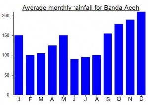
Location
Click on the blue arrow ![]() (top right) to see your current location on the map
(top right) to see your current location on the map
There is report from Metalik (Mahasiswa Fakultas Ekonomi Pecinta Alam dan Lingkungan Hidup) Syah Kuala Aceh already reached the top in 16 days expedition.