Facts
- Elevation: 2,115 m (6,939 ft)
- Prominence: 1,150 m
- Ribu category: Tinggi Sedang
- Province: Lampung
- Google Earth: kml
- Rating:

 (2 votes) Add your rating
 Loading...
 - Other names: Tangkit Tebak, known locally as Gunung Abung
Photos


Bagging It!
The strangely-named Gunung Tebak (‘tebak’ means ‘guess’) used to be one of the most mysterious mountains in Sumatra, with few trek reports to be found online and very little local information on there being any sort of trail to the true summit, despite it being the second-highest peak in Lampung. Its full name is Tangkit Tebak and it is actually the highest peak in a large range with numerous different peaks, the range itself being more commonly-referred to locally as Gunung Abung.
There are two main places that a hike onto the densely-forested range can feasibly begin. In the north-east, less than one hour from Kotabumi, is Tanjung Raja. From the centre of Tanjung Raja (200m), there is a minor road running higher up the slopes of the mountain to around 600m above sea level. A pleasant-looking sharp little peak in the foothills is labelled Bukit Batududuk (723.6m high and ‘sitting rock hill’ in English) on the Bakosurtanal map. One student group attempted to climb Tangkit Tebak from here in 2014 but, even with local help, they found it very difficult. Apparently, locals said they had climbed to the top in about 4 hours, but after 12 hours this 2014 team gave up short of the ‘summit’.
It is almost impossible that it would only take 4 hours to reach the true summit of the range from the Tanjung Raja side, not only because any trail is so infrequently-used that it would be re-opening, but also because the highest point is several kilometres further south-west, beyond other peaks and considerable drops and cols. It is therefore most probable that the locals were talking about the 1,700m-plus peak at the north-eastern end of the range which on some maps is known as Gunung Ulusabuk (1712.8m high and labelled Puncak Satu 7 on Google Maps, perhaps because it is over 1700 metres high and also perhaps as a nod to 17th August being Indonesia’s Independence Day when mountains such as this are hiked). This lower peak is more commonly-hiked now in 2021, and is known as Gunung Abung, a name that – as mentioned above – seems to be sometimes used for the range as a whole.
On the old US military maps of Indonesia, it appears that there is (or was) a triangulation pillar (P.72) at the true top of Tebak near the south-western end of the range, and if so then locals must have been up there in the early twentieth-century at least, however according to locals the only trig pillar was found lower down in the range near Dwikora.
In 2018, it was confirmed that a group of local hikers reached the true summit from Desa or Kebun Tebu near Tribudisyukur on the south-western side, taking an incredible 11 days to find a way to the top! Now that a trail has been made, it is possible to be up and down in two full days (one day up and one day back down again) and about 5 trips by various hiking groups have so far been made since then.
Sadly, access is difficult in 2021, with various departments needing to be consulted with prior to a hike, especially if you have any foreigners in your group. Indeed, it is not clear is permission will be granted in future, so anyone considering a hike here is encouraged to check and check again prior to starting your journey.
Not only is access difficult, the trail itself is very challenging, with leeches, spiky plants, very narrow ridges requiring the use of ropes, and mossy overhangs which are sometimes unstable. In short, you need a local guide who is experienced and knows the way. One Indonesian hiker described this mountain as the Raung of Lampung (referring to East Java’s difficult Gunung Raung) and this is a fairly accurate description, although whereas the trail on Raung is bare rock near the top, the Tebak trail is rotting vegetation and crumbly terrain which is difficult to judge and therefore needs approaching with extreme caution. Permanently fixed ropes are the only really safe approach to trekking this mountain, should the trail become popular and official in future. The positive side of the very narrow ridges is that panoramic views are possible, especially towards the pyramid-shaped Gunung Tanggamus.
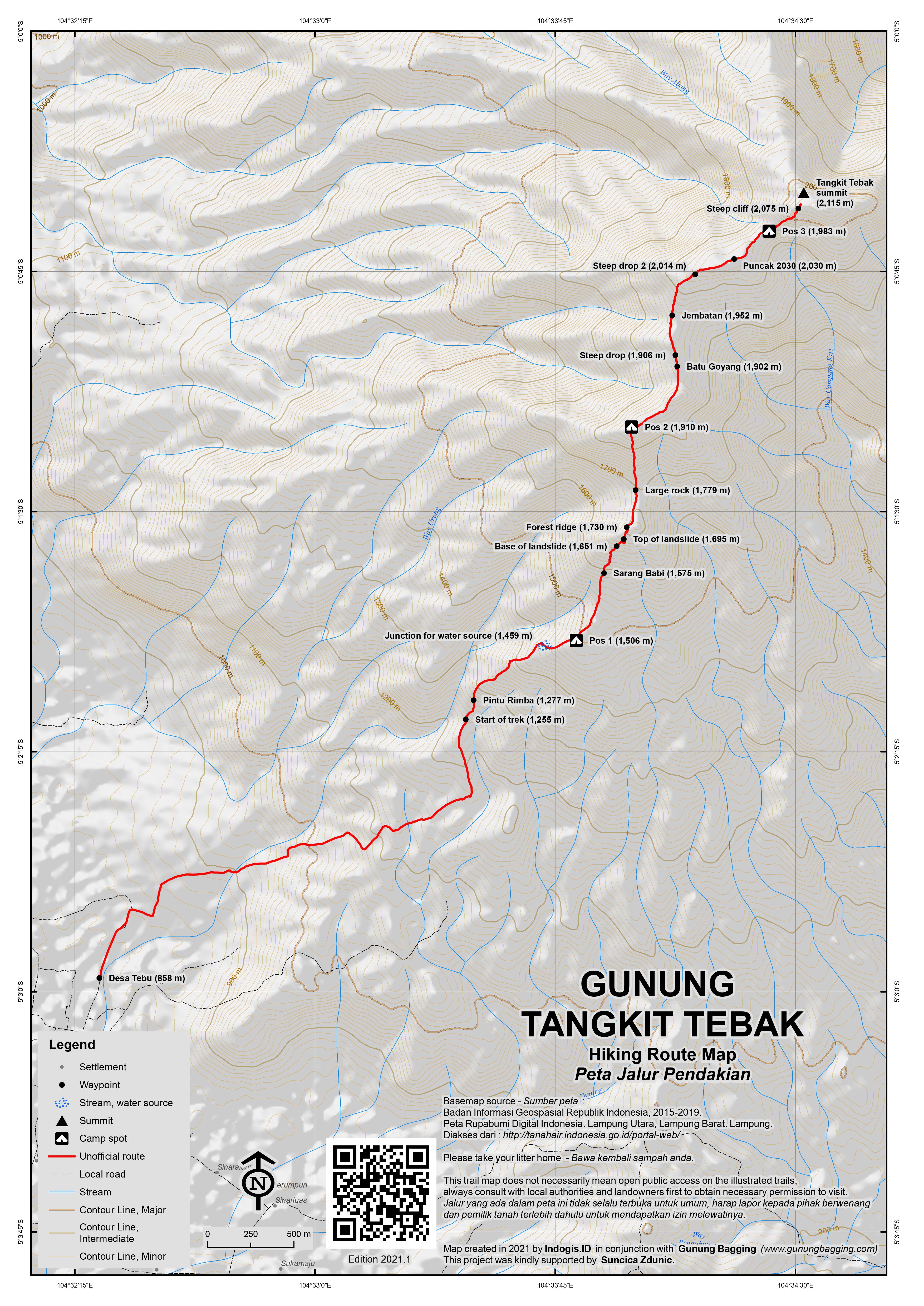
From Desa Tebu (828m), plantation ojeks can be arranged up through the steep, muddy farm tracks as far as Pintu Rimba (1,277m). This saves perhaps an hour of hiking and the views back down to the valley below are exceedingly pleasant. Once in the forest there are a few minor trails criss-crossing each other, including a junction (1,459m) where a left turn would lead to the only decent water source. Pos 1 (1,506m) comes soon after and it should have taken most hikers no more than 45 minutes to get here from Pintu Rimba.
There is not much at Pos 1 except leaves and leeches, although it is flat enough to be camped at in an emergency. Note the two different types of leeches, with red ones on the forest floor and trying to get onto your boots, an the yellow and green ones that wait for victims and drop onto them from leaves! Babi hutan are the usual source of blood for the leeches, and indeed this part of the forest is home to many and the next landmark is ‘Sarang Babi’ (1,575m).
Beyond this is a landslide area which is steep and slippery, starting at 1,651m and ending around 1,695m. A forest ridge (1,730m) is then gained, but the ridge has plenty of ‘duri’ or spiky plants that can make progress very slow. After a great viewpoint on the left (1,770m) on the ridge is a large boulder (1,779m) which is so large it provides some protection from the rain. This is also the point at which you start to notice pitcher plants, with several varieties visible.
Further along the trail, a right turn is needed on another ridge, just before reaching Pos 2 (1,910m). Again, there is not much here and not much flat space for camping, but it is one of the few vaguely flat spots available on the trail. It also marks the end of the leech zone, which few of them living beyond here! It also marks that last place to camp before the narrow, challenging ridges that some hikers will find too difficult, as if the many ups and downs along the forest ridge were not enough!
A good viewpoint on the right (1,900m) soon follows, before the first challenging section which is known as Batu Goyang (1,902m). Here, you need to pull yourself up onto a knife-edge ridge of rock with massive drops on either side and vegetation that is not strong enough to take your weight. For safety, a long rope is recommended at this point. A little further along is the first of two very steep drops (1,906m) where rope is once again essential for proceeding safely. Beyond this is another short knife-edge ridge of rock known as jembatan (1,952m), at the end of which is a difficult step back up onto the vegetated ridge. Again, a rope is advisable here as a fall or accident would lead to absolute disaster at this point.
Beyond here there is one more steep drop (2,014m) where rope is recommended, and then that is it for the challenging sections until the very base of the summit itself. Beyond this steep drop, a high point of the ridge is reached (2,030m on GPS) which might be described as the false peak or Puncak Bayangan. The view here are excellent, but do take real care on the slippery, mossy logs. The trail then drops down to Pos 3 (1,983m) which like the other Pos is not ideal but there are simply no larger, flatter alternatives here. The views remain excellent, and you should be able to see the true summit of Tangkit Tebak ahead of you, less than 500 metres away. Most hiking groups need a full day to reach Pos 3 from the village (even for fast hikers taking no breaks, Pos 1-2 takes around 2 hours and Pos 2-3 takes around 3 hours) and it is the obvious place to stay if you are attempting to reach the summit and get back within 2 days.
Alas, just below the summit is another steep, challenging section (2,075m) where rope is pretty much essential to get up over the near-vertical terrain coated in moss, crumbly logs and weak vegetation. Some will make it and others may think twice given the dangers. For those who do succeed, it is only another 5 minutes to the summit which is crowned with a black summit sign. Back down to Pos 3 takes around 30 minutes or so, and then back down to Pintu Rimba a further 7-8 hours, carefully negotiating the same tricky terrain between Pos 3 and 2.
Near Desa Tebu there is actually a very interesting megalithic site called Batu Berak (or Batu Brak) which consists of many tens of standing stones and other ceremonial collections of rocks apparently many hundreds of years old. There is also a very lovely old weeping fig tree (‘beringin’). This spot is very much worth a visit in its own right, yet is not well known outside of Lampung.
Bagging information by Dan Quinn (April 2021)
Trail Map
For a high quality PDF version of this and other trail maps, please download from our Trail Maps page.
Local Accommodation
Practicalities
- Getting there: The closest main town is Kotabumi which has a train station and one executive train each evening from Bandar Lampung / Tanjung Karang). An approach from the south-western end begins from the small road – Jalan Raya Tri Budisyukur – running down south from the main road at the Soekarno Monument at Sumber Jaya (about 1hr 20min by car or motorbike from Kotabumi) down 8km or so to Purawiwitan / Kebun Tebu.
- Guides and GPS Tracks: Want a PDF version for your phone? Looking for a guide? Need GPS tracks and waypoints? Gunung Tangkit Tebak information pack can be downloaded here.
- Permits: Complex, especially for non-locals. Officially, you are requested to ask for permission from PolHut (polisi hutan), Pak RT (in Desa Tebu), and even Lampung immigration (if you are not Indonesian). It is not clear how easily such permission would be granted and would probably require lots of time and advance planning.
- Water sources: Available only before Pos 1, so be sure to take plenty.
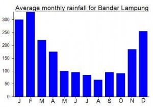
Local Average Monthly Rainfall (mm):
Had it confirmed yesterday from a local hiker, Dicky, that there is indeed a triangulation pillar near the summit. It is a bit damaged and covered in moss but still standing. Presumably this is located a short stroll from where the summit signs are.
This mountain had long been my closest un-climbed Ribu, for several reasons. Nobody seemed to know much about it until recently. Anyway, we did finally hike it, but it’s a difficult one to recommend at the moment, mainly due to access issues.
We took the ferry over from Merak, and conditions were so clear that we could even see Rakata in the distance. I think that is the first time I’ve ever seen it from the ferry crossing to Lampung.
After a night in Kotabumi, we set off with our guide to the mountain and the very friendly village at the base. The hike itself was challenging – especially once on the very narrow ridge beyond Pos 2. If this ever does become a popular trek, then there will need to be ropes installed permanently in a few places for basic safety.
It rained much of Day 1, so these tricky sections were even more treacherous! I was definitely on the edge of my comfort zone, and carrying large backpacks in some places was difficult. Day 2 started with great views from Pos 3, before we made an attempt on the summit. My friend made it up, but I was stuck at the final cliff just 5 minutes from the summit, too worried about falling on the slippery, crumbly terrain to proceed any further. People well-acquainted with rock-climbing would probably have few issues with it, but I am not a fan of taking risks so I was happy enough a little short of the summit waiting for the others.
We then had to get back down, ideally before the afternoon rains. Thankfully we did make it back to Pos 2 before the rain started, and therefore back to relative safety. Coming down from Pos 2 to Pos 1 was very slippery in the wet weather but not anywhere near as challenging as Pos 2 to 3.
The biggest surprise was waiting for us at the edge of the forest, where various people were waiting for us. It seems that foreigners visiting the area is highly unusual and someone reported us as they assumed we were not just hiking but perhaps looking for wood or animals or… something. The authorities were basically just doing their job but it was a bit of an ‘over the top’ response and the last thing we were expected after a tough hike. It took a while before numerous officials were understanding and eventually the problem was resolved as they understood we were not looking for anything except a good hike. But although Indonesians have hiked here before it may be more difficult in the future, with various departments requesting that you ask permission first. Foreigners may not be granted permission to hike here as the trail is not official. You need to check the latest information locally with all relevant authorities.
So, proceed with real caution here, and check with the authorities before starting any hike. In brief, a challenging hike and probably challenging to be granted permission by all relevant departments too.
Hey there,it’s an interesting topic about Tangkit Tebak mount. Can we have further disscussion about this mount? Because that is true there was a journey to the top of Tangkit Tebak in the mid of 2018, it’s HPPA Cakrawala STT – PLN Jakarta who’s go there, my organization of nature lover in the college. Maybe we can help each other
Many thanks Setiawan.
I am already in touch with one of your friends in Lampung and hope to visit in 2020.
Best wishes, Dan
Wow that’s great, i have a plan to goes there too in 2020. Maybe we can get there together
Good news, Dan! Looking forward to set out for Tebak soon. Quite possibly for Ranau too and gunung Pugung with Seminung
So, it is confirmed that a local group reached the top from the western side at Tribudisyukur last year, taking 11 days to find a way to the top! One of the team emailed me about this, and asked about the pillar I wrote might be at the summit (trig pillar made during the Dutch era for mapping purposes). Now, these triangulation symbols on maps often mean that a pillar is there or was there originally (or that triangulation occurred in some form – perhaps not requiring a pillar). This team did not find a trig pillar at the top, and mentioned a local news story about a cement pillar being found in the forest in 1997 and getting onto the local news….. https://www.youtube.com/watch?v=hfyx_YUJwtA
This is near Dwikora which is near Tangkit Tebak. Of course, this ‘mysterious pillar with Japanese writing on it’ is almost certainly a trig pillar from the Dutch era. If there really is Japanese writing on it, this would have come later. It is not clear exactly where the pillar in the video clip is…. somewhere deep in the forests, presumably on a peak of some sort or other, but by no means definitely the highest peak of the Tebak range.
Anyway, back to the hike itself which sounds newly accessible, there are apparently good views in places and pitcher plants. I imagine I will be back in the area before too long, perhaps to combine a trip here with a trip to Danau Ranau now that there is a Wings Air flight from Bandar Lampung to Krui….
where do i can find the old US military maps of indonesia? can you help me?
Hello there. Thanks for your messages. I will send you an email this evening. Dan.
the top of tangkit tebak was reached by group of nature lover, it started from Tribudisukur and reached the highest altitude of 2143 masl in august 2018
It appears that a local group may have reached the top in late 2018. A series of photos was published on Facebook but it remains unclear where they started from and the location of the peak they regarded as the sunmit. Either way, it may get slowly easier to hike this one as more groups give it a try….
Well, ‘Guess Mountain’ really does leave you guessing. Residing as I do in Jakarta, it’s my closest unbagged Ribu, and will probably remain so for a long time. I had seen it from a distance before, both from the top of Gunung Pesagi and also from the main road between Kotabumi and Sumber Jaya when me and Heri did a mad trip on his bike from Bandar Lampung to Danau Ranau. The day we drove past on the road it was hazy/cloudy, and this past weekend when I went back for a closer investiagtion I didn’t get any better luck with the weather… just low cloud obscuring a decent view of the range.
I had tried and tried to find any local hiking clubs who knew anything about the range. Very little information. I finally found one student no longer resident of Lampung who had tried to climb Tebak from the eastern side at Tanjung Raja but had little else to go on. After inviting them to join me on an investigative trip to Tebak, the Mapala at the main Lampung university demanded that I visit their university in Bandar Lampung once I had arrive at the airport on Friday night, an hour-long backtrack diversion and something I found bizarre and not reasonable given I was booked on a train to Kotabumi just an hour after arriving. My suggestion to meet in Kotabumi early on the Saturday was not acceptable to them, for whatever reason. So, anyway…..
After the usual chaos at CGK with incorrect information on the information screens, I flew from Jakarta to Bandar Lampung on Friday night (just a 23-minute flight in which the aircraft doesn’t get higher than, say, Kerinci or Rinjani before descending again). From the upgraded airport (another one…. full marks Jokowi for pushing ahead with all this much-needed infrastructure improvement work… proof he has the interests of the country and people close to his heart which is sadly a rare thing in politics) I got an ojek to Rejosari (15min towards Bandar Lampung and then down a dusty track) the closest train station serving executive class trains. They could really do with an airport train station as the line is very close to the airport.
I got on the Sriwijaya train heading to Kertapati (Palembang’s train station) and got off at Kotabumi around 11pm. This was much less traumatic that the hideous pot-holed mess of Lampung’s main roads and frankly if I come to this area again I will do my best to stick to the train where possible.
The next morning I tried using the Grab app to find an ojek guy who would take me to Batu Berak to the west of the range so I could ask around. No luck. The locals in the hotel showed little initiative, despite me offering Rp300,000 for half a day’s outing on a motorbike (probably only needing Rp50,000 fuel or so). ‘Tidak ada ojek disini’ came the reply. I continued to search and finally found one at the fuel station by Tugu Payan Mas near the friendly traffic police chaps. They were surprised by someone wanting to go 70km on the back of a bike but the local ojek guy agreed to Rp300,000 for half a day.
It took us just over an hour on a terribly pot-holed road to reach SUmber Jaya and the Sokarno statue junction. On the way there, all views of Gunung Tebak were disappointing…. low, low cloud. Also, the ojek chap insisted I let him keep my bag down at the front near his knees. Lampung and South Sumatra still have a reputation for thievery on the roads. As if the pot-holes aren’t enough…. I wouldn’t recommend anyone using a motorbike on this road after dark….. the holes number in the hundreds and are deep enough to cause fatalities.
From Sumber Jaya the minor road snakes up over a minor hillside before descending past lovely rice paddies towards Purawiwtan. I though I saw a sign for Hotel Anugerah here, but the hotel didn’t look open or busy, but might be worth investigating as it might be a better base to find info than Kotabumi.
Batu Berak was very impressive. Entry by donation. There were lots of Ibus from SUmberjaya and their children or students so I got completely mobbed for photos – very few tourists or foreigners come here. I also spoke to the very friendly Pak Ristiyo Widodo, the guide at the megalithic site. I asked him about Gn Tebak, known to him as Gn Abung. He didnt know much but later told me one friend of his had tried to climb it but even with 2 or 3 days he had found it difficult and returned due to a lot of rocks making progress really tough. I asked about tigers… apparently local people report seeing them from time to time. Not surprising given how infrequently humans enter this large area of forest.
On the way back we made a detour to Tanjung Raja at the east side of the range, where there is now an Indomaret. Not much information to be found here, and equally poor weather for photos of the mountain. I think the west side is a much better prospect, if local folk can be found to spend a few days up on the range.
Back at my hotel in Kotabumi the Ibu was complaining that I had only booked for one night but it was after 12 noon. I explained that I had booked twice, two bookings each for one night. She seemed utterly confused by this. I decided to leave. In any case, Kotabumi is not the most interesting town. I got a yellow angkot to Puspa (the tiny bus terminal) for Rp4,000 where as luck would have it there was a seat in a shared car for Rp50,000 to Bandar Lampung. Hopped in. Terrible journey though, nearly 3 hours, with lengthy areas of total chaos, dirt tracks, roadworks and stuck behind trucks travelling at 15 miles an hour over a road that resembled the craters of the moon. Classic SUmatra.
Anyway, I hope someone else has a proper try at climbing this mountain from the west.