Facts
- Elevation: 1,684 m (5,525 ft)
- Prominence: 1,106 m
- Ribu category: Kurang Tinggi
- Province: Jawa Barat (West Java)
- Google Earth: kml
- Rating:


 (7 votes) Add your rating
 Loading...
 - Other names: Called ‘Tampo Omas’ in the ancient Bujangga Manik script.
Photos


Bagging It!
Gunung Tampomas is located northeast of Sumedang (480 metres above sea level) – a town famous for its delicious tahu (fried tofu) – and is easily accessible by public transport from Bandung. Whilst no giant in terms of elevation, Tampomas is an easy and enjoyable hike – perfect as the first of the season or as a warm-up for something more challenging – and there are very pleasant views from the top to most of the major peaks in West Java.
Aside from the suggested possible origins of the name of the mountain given below at the bottom of the article, some say that it comes from ‘gunung tanpa emas’ or ‘tampah emas’ which means ‘mountain without gold’. Even if Mount Tampomas is lacking in gold, its lower slopes on the southern side at Cibeureum Kulon are certainly being seriously quarried for rocks of some sort or another.
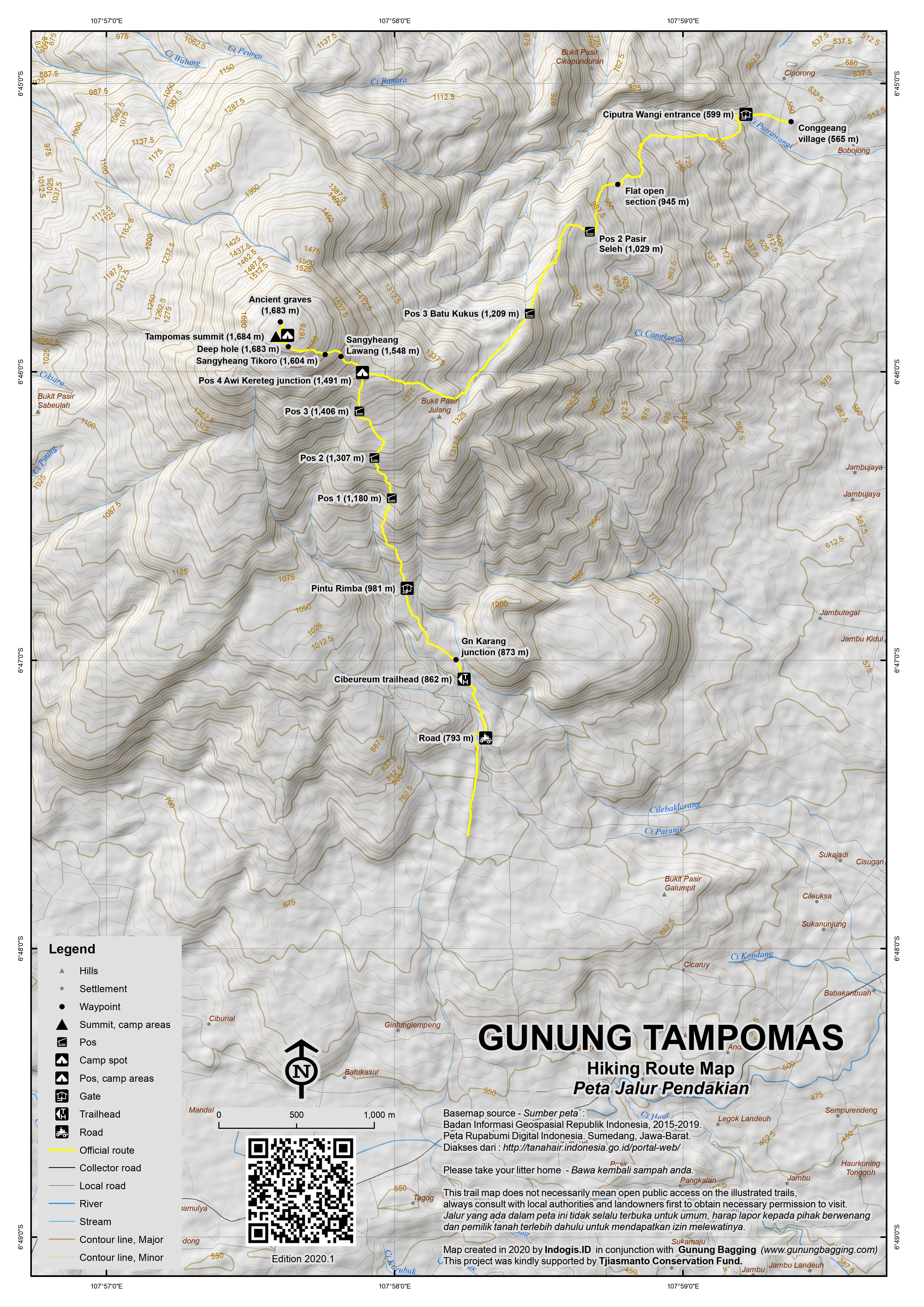
This is one reason why the Narimbang route (from the north-east) is more pleasant than the Cibeureum route (from the south), but the best thing to do is up one side and down the other, hopefully having arranged transport to collect you at the other side. Both routes require around 3 hours up and 2 hours back down.
Route from Narimbang
The route from Narimbang starts near Conggeang village at Ciputra Wangi Waterfall (599m) which is Pos 1. From the signs, warungs and ticket booth, the trail to the peak leads to the left and snakes up the hillside. There is an open, flat section of wide trail (945m) before reaching the pleasant warung at Pos 2 (Pasir Seleh, 1,029m). It should have taken you just over 1 hour to reach this point. If conditions are clear, this is a great spot for a coffee and a snack and you may even be able to see the occasional plane coming in to land at the new West Java International Airport a short distance away near Majalengka. The couple who live here grow bananas, onion, chili and papaya up here.
Further up the trail you get a glimpse through the trees on the right side of the trail of the flattish top of Tampomas – still a fair distance away. In rainy conditions you may meet one or two leeches in this part of the mountain, but they are not especially common. Pos 3 (1,209m) is the next landmark and is named Batu Kukus, presumably because the largest of the cluster of rocks vaguely resembles a rice steamer. In inclement weather, this rock would certainly provide some shelter from the rain. In March 2019, 3 teenage hikers from the Indramayu area sadly died in this area in bad weather – a tragedy that was easily preventable, especially given how short both trails up the mountain are.
Pos 4 (1,491m) is Awi Kereteg and being the junction between the Narimbang and Cibeureum trails is a very important point. There is also a reasonable amount of space here for those choosing to camp below the peak itself. It should have taken you around 2 or 2 and a half hours to reach this point, not including any time you spent at the warung back at Pos 2. Whilst navigating is pretty easy, it is important to mentally check the two trails here so you do not end up on the wrong one on your descent.
The path gets steeper and rockier from this point on, and there are a few places where you need to take care on steep and sometimes slippery rock. This rock is clearly volcanic in origin. The next landmark is a minor rockface at Sangyheang Lawang (1,548m) – also called Watu Gede (‘large rock’). There used to be a simple hut here but it was gone in 2019. If you look back down the trail, you may well see Gunung Ciremai – West Java’s tallest peak – in the distance. Shortly beyond this is Sangyheang Tikoro (1,604m), a minor point on the trail as you edge closer to the top. The summit area of Tampomas, known as Sangyheang Taraje (or Pasarean), is less than 10 minutes further and from Pos 4 to the peak should take no more than 45 minutes in total. Just before the peak there is a deep dark crevice to the right of the trail, which is apparently the remnants of an ancient crater.
The views from the boulder-studded peak are wide open and very pleasant – westwards to Bukittunggul and surrounding hills and south towards the many peaks near Garut – Gunung Guntur, Cikuray, Papandayan. There is enough space for at least eight tents in this area, and if you spend a Saturday night here you are unlikely to be alone. The highest point of the mountain appears to be the large boulder just north of the man-made pillar.
Approximately 100 metres to the north of the highest point are two ancient grave areas, known as Pasarean, which are certainly worth a visit. These are apparently tombs from the ancient Sundanese kingdom of Pajajaran (which existed until around 500 years ago and was Hindu). This minor top is only seemingly a metre or two below the viewpoint summit, so keen baggers are advised to visit both just incase!
Back down to either Ciputra Wangi or Cibeureum should take around 2 hours, not including breaks.
Route from Cibeureum near Sumedang
Follow the road from Sumedang towards Cirebon for about 6km, past the village of Cimalaka and to an area known as Desa Cibeureum Kulon. Take a left up a narrow road opposite Masjid Al-Bashir and next to a Bank Mandiri ATM (previously at a sign with “Lokasi TPA”). Follow the bumpy, rocky road to the sand quarry. There will probably be a large number of yellow quarry trucks coming the other way.
Head straight up the hillside, ignoring a left turn and then a right turn. After approximately 3km you will reach a sharp bend – park your car before this point. Just one minute beyond the sharp bend, take the path on the left heading up through farmland (793m). Five minutes later, take a left on a farm track and into pine woodland. Soon after this you reach a wooden hut (862m). It should have taken you no more than 15 minutes to reach this place (or one hour if you have walked all the way up from the main road).
Just beyond the hut is the junction (873m) for a minor top called Gunung Karang. This is of course not the mountain in Banten but another Gunung Karang (with an elevation of 1,011m) known locally as Anak Gunung Tampomas (‘the child of Gunung Tampomas’). It is not very far from the junction with the main Cibeureum trail and has a rocky outcrop at the top.
Don’t take a right here for Gunung Karang – continue straight ahead on the wide track through the pine woodland.
From this point on there are plenty of signs which should hopefully confirm that you are on the right track! The path leads you up through more pine woodland – most trees have small coconut shells attached to their trunks to collect the resin/sap. An important junction is next at an elevation of around 981m. Turn left here, off the wide woodland track and into the proper forest. You might call this spot ‘pintu rimba’ or ‘forest entrance’.
From here, the trail is easy to follow as it leads up the mountainside and via 3 Pos, none of which are ideal for camping but could be used if absolutely necessary. Pos 1 is at 1,180m, Pos 2 at 1,307m and Pos 3 at 1,406m.
The path begins to get steeper and the vegetation becomes more natural forest-like. According the the local forestry department, Tampomas forest is home to kancil (mouse deer), lutung (monkeys) and babi hutan (wild pigs). After a total of around 2 hours (or 3 hours if you walked all the way up from the main road) you should have reached Pos 4 (Awi Kereteg, 1,491m) where the path joins up with the other hiking route from Narimbang. This spot offers enough space for 5 or more tents.
It is less than one hour from here to the peak and fit hikers might manage it in just over 30 minutes – see the route description above.
Returning the same way from the peak to the tarmac road and quarry at Cibeureum takes less than two hours. You may be able to hitch a ride on the back of a quarry truck down to the main road and get an angkot back to Sumedang. Best allow an extra hour just incase you cannot find a ride – there are no villages in this area and only occasional motorbikes. If you descend via the Narimbang trail, allow about two hours back down too, but best arrange pick-up at Ciputra Wangi waterfall in advance if possible, or allow an extra 30 minutes to walk to the main road and search for public transport.
Back in Sumedang, there are a couple of hill-related tourist spots worth visiting if you have extra time. First of all, Bukit Toga (approximately 700m above sea level), which is a decent viewpoint over the town and towards Tampomas. Secondly, Gunung Kunci (‘key mountain’, originally spelt Koentji), an old Dutch fortress and prison built in 1914. Gunung Kunci (514m) is just to the east of Gunung Palasari (643m) which is pine woodland with a telecommunications tower at or near the top.
In north Sumedang is an attractive peak called Gunung Kecapi (656m). It slightly resembles Arthur’s Seat in Edinburgh, Scotland, but it is unclear if there is a path to the rocky top.
Bagging information provided by Daniel Quinn (updated June 2019).
Trail Map
For a high quality PDF version of this and other trail maps, please download from our Trail Maps page.
Local Accommodation
Practicalities
- Getting there: There are plenty of buses running between Bandung’s Cicaheum terminal and Sumedang. There are also Primajasa buses from Jakarta’s Kampung Rambutan to Sumedang but the slow pace can be frustrating. From Sumedang to both starting points is about 30-40 minutes by motorbike or car. The closest airport by far is the brand new West Java International Airport near Majalengka but at the time of writing (2019) this remains a fairly quiet airport. The closest train stations are Rancaekek, Bandung or Hargeulis (in Indramayu regency). Despite being a very small station, Hargeulis serves several executive class trains and it is just 2 hours from Gambir or Pasar Senen. Unfortunately it currently takes over 2 hours to reach Hargeulis from Sumedang due to poor quality or indirect roads. Still, this can sometimes make more sense than heading back to Bandung on what is a frequently jammed main road (typically 2 hours to cover just 60km). A new toll road from Bandung to Sumedang (and presumably onwards to the new West Java Airport) is under construction at the moment.
- Guides and GPS Tracks: Want a PDF version for your phone? Looking for a guide? Need GPS tracks and waypoints? Gunung Tampomas information pack can be downloaded here.
- Trip planning assistance: Would you like Gunung Bagging to personally help you in arranging your whole trip? Please contact us here.
- Permits: Tickets at Curug Ciputra Wangi, Narimbang Rp5,000 per person. Not required on the Cibeureum route at present (2019).
- Water sources: Available at the warung at Pos 2 on the Narimbang route. None seen near the trail on the Cibeureum route.
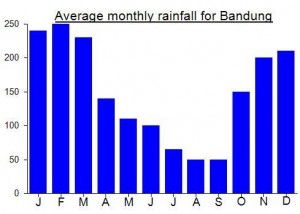
Local Average Monthly Rainfall (mm):
Location
Origins and Meaning
(unclear) There could be two possibilities. (i) In Old Javanese the word tampo means “rain, mist” so tampo mas might mean “golden rain”. “Golden rain” (usually udan mas or hujan emas) is a popular poetic term that might respectfully or affectionately be applied to a mountain. (ii) In Sundanese tampeu means “overlooking something” so tampo mas might mean something like “the golden mountain that looms over us”. (George Quinn, 2011)
Having not been up Tampomas for 9 years and never having tried the Narimbang route, I thought it was time to head back there. I love tahu and Sumedang is almost a great town (just too much traffic like almost everywhere else in West Java now) with scenic little peaks scattered around the outskirts. We stayed in Hotel Asri in the shopping mall, and whilst it was a difficult place to get to in the car at first, it turned out to be a good choice.
I had already been in touch with Bobby, a local student who also runs a hiking club called Mapala Garjamara. If you need help for this hike you could send him a message on +6282123905621. He met me at 5am and we got a Grabcar round to Narimbang for Rp70,000 (about 30 minutes at that time in the morning, but assume 45min later when traffic builds up).
There was nobody at the ticket booth so early on a Monday morning – weekends are by far the busiest time. The weather was pleasant but a little hazy, so by the time we were at Pos 2 warung chatting with its friendly owners we couldn’t make out the new airport in the distance, though perhaps you can only see planes preparing to land rather than the airport itself. As most domestic flights to Bandung are soon to be re-routed to this airport, I would imagine the area will get more and more developed and not necessarily in a good way. Let’s hope Tampomas isn’t negatively affected. Certainly, at present if you are coming from Surabaya specifically to hike Tampomas, then the Citilink flight to Kertajati / Majalengka is definitely the best choice for avoiding a long road journey.
The owners of the warung told me about various other foreigners who had hiked Tampomas, including a teacher from Cirebon. After a coffee we continued on, up what is a very pleasant gradient. After the junction with the Cibeureum trail things do get a lot steeper, but even so this is an easy hike by Indonesian standards, and the views are great. It was clearer than last time, at least down to the Garut mountains. No other hikers up here on a Monday morning. Spotted a monkey and a few birds and heard a few forest chickens but that was about it.
Highest GPS reading was about 1694m at the big boulder at the viewpoint. Graves area was a couple of metres below that but certainly not much in it. The graves area seemed more open than last time – perhaps due to hikers using tree branches for firewood. Atmospheric spot, but no views. I wonder if any studies have been done to accurately date this site….
We were down at the Cibeureum trailhead in just 90 minutes. It seems the old warung has gone, but there are some new signs, and after a short walk along the road we managed to hitch a ride in a truck that had been carrying rubbish. They were going all the way to Sumedang – perfect! The old women who saw me leap out of the back of the rubbish truck when we reached the roundabout in Sumedang were shocked to say the least!
Bobby and his friend agreed to take us to Bukit Toga and Gunung Kunci before we had to leave Sumedang. Sadly his friend’s motorbike couldn’t manage the steep road up to Bukit Toga so we had to turn back due to lack of time. It was a little hazy by this time anyway, but in clear weather (e.g early morning or after a storm) the panorama over the town and towards Gunung Tampomas is probably pretty good
Gunung Kunci was very interesting – an extensive Dutch fort and prison with tunnels and barbed wire and signs forbidding romantic activity in the pleasant pine woodland! Worth the Rp3,000 entry fee (Rp20,000 for evil foreigners unless you hold up your KITAS and remonstrate with them as I did!)
We had booked tickets back to Jakarta on the train from Hargeulis near Indramayu. This was for two reasons – firstly to avoid the hellish traffic around Karawang, and secondly just to try it out. Grab brough up the price of around 250k but none of the local drivers would agree to that price and kept asking for much more. Due to lack of time we ended up paying 350k. This is quite a bit considering you could just jump on a bus all the way to Jakarta for a fraction of that price, but not too much if you took the road via Buah Dua as we did. Google Maps recommended this route. It took about 2hr 20 min and at least 30 minutes of that was terribly bumpy, landslide areas that you would not want to risk in rain. Luckily we made it to Hargeulis station in time.
The views from the north of Tampomas up to the mountain are particularly fine. I have read that there is a third route up from the Buah Dua area (north of the peak) but I think this is incorrect as there is no detail about this and it may just refer to the fact that part of the mountainside is in the Buah Dua area. If you know otherwise, please drop me a line. For those thinking of using Hargeulis, I recommend using main roads which make be longer and less direct but will be a lot better than the jarring and potentially dangerous experience we had! Fascinating ride though, especially over the Sungai Cijurey.
I am looking for other hikers who wish to hike Mt. Tampomas this year or early 2024! I am an Indonesian national who can’t seem to find any Open Trip/guided tour services to Mt. Tampomas!
Hi guys,
I live in Sumedang. So, to anyone who wants to hike Mt. Tampomas and need any assistance, feel free to contact me.
Halo kang dindin, saya harap kita bisa bertemu dan bercerita banyak di tanggal 22 ini. Saya dan teman teman tampomas bicara akan mengadakan pendakian bersama ke tampomas
Hey! Thinking of checking it out around the 27th of September… Is there a contact number? 🙂
Hello Mas DindinMK, Please let me know your contact info. I plan a trip to Gunung Tampomas
Sure thing! You can text me (081322-3322-fourty two)
Info about climbing it from Narimbang :
– To join the village, just google maps “Narimbang, Jawa barat”.
– You can park your car 100m after the intersection of “Majelis Taklim (MT) Al Masturiyah” (located on google maps).
We pay the local people a small fee.
– Reach the starting point named “Curug Ciputrawangi” (all local knows). You can park there directly if you arrive by motorcycle.
– There is an entry FEE : 3000rp only (Same for Foreigner)
– Start the hike on the south side of the river. (A lot of other small paths cross the one for the top. Just Keep up)
– After one hour 30 minutes you shall reach a small warung own by Sasli for already 5 years. That is your last point to get water. Possibility of Camping.
– Keep up. Only one way and Sasli helps if you get confused.
– 2 hours to reach POS IV. Slippery because a bit dusty.
– 30 min-45 min for the top.
– Down the same way. A lot of warungs at Curug Ciputrawangi.
* The area seems often cloudy, we didn’t get a clear view. The hike is fresh under the trees. We saw boars and wild cotton plants 🙂
I climbed with a group from the Narimbang route two weekends ago. We were on the summit from the starting area in around 3 hours and 45 minutes, followed by1 hour at the marked tombs for lunch (Indo Mie flavoured with wild grasses that one of my party picked on the way up) and then almost exactly 2 hours to reach the bottom rest area. As mentioned above the route from Narimbang links up with the other route at Pos 4, after which it is a nice walk up to the summit. Our trek up Tampomas was leg 1 of a long (but rewarding) weekend wherein we climbed Gunung Bukittunggul outside of Lembang the next day. It was nice to have gone via the Narimbang route which was not very steep but took a bit longer.
nice information!
i’ll plan to hike the tampomas on the 10 – 11 October.
Thanks!
i had a interesting climb of tampomas last saturday. i arrived in bandung from singapore much later than i anticipated thanks to air asia.after a quick stop off to get a gas cooker i decided to pay extra to the taxi driver to take me to sumedang rather than mess around on public transport. in hindsight maybe public transport wouldnt have made any difference since its snails pace all the way. anyway by the time we arrived in sumedang it was already getting late but i wanted to get on the mountain .i had my tent and cooking gear and wanted to put it to use.problem was neither i or the taxi driver were entirely sure where we were going. i followed the instructions as above and i was very fixated on looking for the lokasi tpa sign.i never saw it.but at the turnoff we did stop and ask some locals. they sent us off down further towards cirebon. my taxi driver seemed convinced that he knew the way. we ended up in narimbang which was totally off. so we turned back and we took the narrow road with the broken light( no lokasi tpa sign). eventually we got to the warung at 6.30 pm.i left the taxi and started off with very little light left and on my own.no big deal i thought. then came the rain( the wet season is well in truly still alive).then came the bugs.leeches in particular.then came my dodgy head torch. i made my way to the camp area where the narimbang trail joins.i am amazed at how much wildlife is on this mountain. the whole night i heard animal noises outside my tent and a couple of times i heard trees falling down. the bigfoot crew on discovery channel would of had a field day.then in the early hours i opened my tent for maybe 10 seconds and a big spider with a few of its babies took the opportunity to crawl in.for the next few hours i ended up chasing this spider around a 1 man man tent.the bloody thing wouldnt die no matter how many times i hit it with my boot.
at daylight i made the half hour trek to the summit. .the views at the summit were great in the direction of papandayan.cikuray looks impressive.after hanging out with a couple of locals that were camping at the summit i made my way back to the warung. as others have said here i was surprised how steep this climb is. it was steep enough to give me knee issues on the way back down.from the warung i had a slice of luck when a kid was driving past on his bike coming back from studying his mice in the local dump. he gave me a lift down to the main road and within 5 minutes i caught a bus in the direction of cirebon to take on ciremai with a dodgy knee.
Whoever keeps this mountain clean is doing a great job. There must be dozens of people climbing up each month but there’s hardly a trace of the plastic trash that scars some other popular trails. Perhaps the Gerakan Bersih Gunung Sumedang Hijau, whose well-made signs are visible on a couple of tree trunks, are the ones responsible.
Thanks also to Dan for the easy-to-follow directions here.
We had a car to take us up from the main road to the warung with the green sign. On the way down the warung was actually open and the owner helped to get an ojek sent up to carry us down to the main road, saving a 45 minute walk.
Our time for the round trip from the warung was 6 hours- 3 hours up, 40 minutes hanging around the top and visiting the atmospheric gravesites and just over 2 hours down. GPS altitude was 790m at the warung at the start, 1450m at the campsite at the junction with the Narimbang route and 1697m at the summit.
According to hikers we met, the ascent from Narimbang is farther but less steep than the Cibeureum route. Access to Narimbang from the main road is from the Legok junction east of the turn off to Cibeureum. It’s on the same route as the Cileungsing hot spring (http://cipanascileungsing.web.id/) so it shouldn’t be too hard to reach.
When we reached the summit at 9 a.m. the clouds were just holding off but the air was already too hazy for clear views, so an overnight camp for dawn at the summit would be an interesting option. If you don’t bring a tent, you could sleep by the gravesites in the pilgrims’ shelters, which have raised bamboo platforms and metal roofs.
Very much interesting and helpful information. Thanks for it.
I will spend some time in the area and I wonder if there are access routes to the crater at the west side of the mountain, starting from Subang?
Halo stan Bukan kawah, tapi ada semacam goa sesudah sangheyang taraje, saya boby yang menemani Mr.daniel beberapa hari yang lalu. Tapi Kemarin saya tidak menemukan nua karena sudah tertutup rumput rumput yang panjang
Well thanks for all the info on Tampomas on the GB website. A friend and I climbed it last weekend. A good time had by all, was steeper than I thought for the last two hours or so. Once we got to the top there were probably 20 people already up there. One large group was from a hiking club in a nearby town. Nice folks.
Hi Jon
I’d allow just over 4 hours to the summit and back, but an extra 45min each way from the main road.
About how long does this hike take?
How far (walking) from Desa Cibeureum Kulon to the warung with the green sign?