Facts
- Elevation: 3,150 m (10,335 ft)
- Prominence: 1,761 m
- Ribu category: Sangat Tinggi
- Province: Jawa Tengah (Central Java)
- Google Earth: kml
- Rating:

 (30 votes) Add your rating
 Loading...
 - Other names: Sundoro, Sendoro
- Eruptions: 1971, 2011-14
Photos


Bagging It!
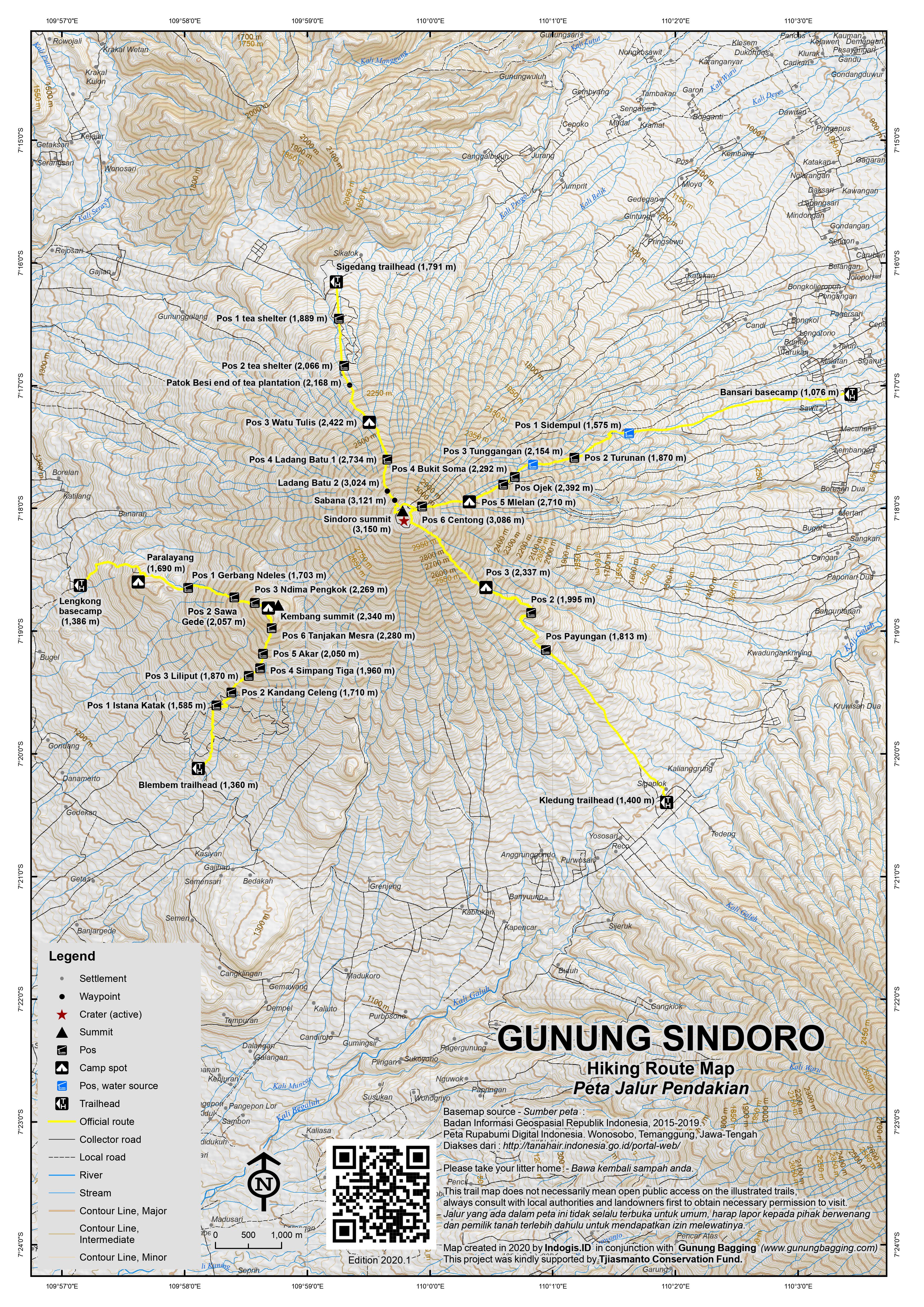
Mount Sindoro is separated from its similarly conical but slightly higher neighbour, Gunung Sumbing, by the Kledung Pass (1,400m). Together, they dominate the Dieng plateau area and can both be climbed from Kledung village where there is a decent hotel. There is another straightforward and slightly shorter ascent from the north at Sigedang (1,791m) and a couple of less popular routes from the west and east respectively.
For its size, Sindoro is an easy hike and would make a great introduction to hiking in Indonesia. From the top there are great views to Sumbing, Merapi, Merbabu, Ungaran, Slamet, Dieng plateau’s high ridge Gunung Prau and the north coast of Java. Sunrise is usually magnificent so it is worth climbing overnight.
Camping at the top is not advised at present (2019) due to poisonous gases near the summit crater (this has been the case since 2011 – and one hiker died camping by the crater in 2013). It is also a very good idea to wait until after 7am to peer into the active crater, and not to spend much time close to the gases.
If it fits in with your plans and you can find a willing guide, it is obviously best in terms of enjoying the different views of other mountains to hike up one route and descend via another. A north-southeast traverse (Sigedang-Kledung) or vice versa is excellent, and so is east-north (Bansari-Sigedang) or vice versa. Finshing in Banaran (west) is ideal for those continuing to Dieng, but this is a less well-known route at the moment so you are advised to take a guide from Banaran for this.
There is no huge time advantage to one trail over another, but Sigedang is the highest trailhead and Bansari the lowest (unless you take an ojek). The small lake at the top only exists during the rainy season, and not all the routes have reliable water sources, so make sure you take plenty with you and assume no availability on the trek itself.
At the summit, there are actually two deep craters next to each other and these have changed rather dramatically over the last decade as volcanic activity has increased considerably. The one on the Kledung side (south) is smaller, swampy-looking, and with several names written using stones by foolish local hikers. Connected to this is a larger, deeper, more northern crater which was partially filled with water back in 2010. Since 2011, the water has almost entirely disappeared aside from a (presumably hot) bubbling pool and there is lots of fumarole activity on both western and eastern edges of the crater in 2019.
If you follow the crater rim further round to the north, it descends to a large, flat sandy area which back in 2010 was grassy. It sometimes has a small lake in it during the rainy season. This would appear to be the remains of a very old, shallow third crater and prior to increased activity since 2011 would have made a great place to camp. Further round, to the western side, is the alun-alun, an even larger flat area with a grave or monument in the middle. Like the occasional lake area, this too is now sandy rather than grassy since 2011. Given the present fumarole activity it is not recommended at present (2019) to camp near the top. Check with guides regarding the situation in future for if/when activity ceases.
Much of the crater rim is of a very similar height. The highest reading on my GPS back in 2010 was on the edge just above the shallow third crater (occasional lake) and in 2019 the GPS gave its highest reading of 3157m on one of the similarly-high twin tops on the eastern side near the Bansari trail. It is possible the highest point has moved since activity has increased and altered the topography a little and some portions of rim may have collapsed. It takes only 15 minutes to circuit the crater rim so baggers don’t need to worry too much about missing the very highest point as long as they’ve had a full wander around the crater edge!
Back in 2010, there was lots of edelweiss, grass, and lots of cantigi bushes (a common vaccinium species on volcano peaks in Java) but after years of activity the area is currently more barren-looking, with less plants, and more sand and rocks, not to mention the active fumaroles.
The view is unarguably one of Java’s finest in clear weather early in the morning. To the south-east are Lawu, Merbabu, Merapi and Sumbing. To the northwest are the Dieng hills including Prau and off in the distance to the west is Gunung Slamet. In clear weather you can also see the north coast of Java.
Route from Kledung (SOUTH-EAST):
This is still the most popular route. From Kledung it takes around 5 – 6 hours to the top or slightly less if you get an ojek for the first section. From the main road at Kledung, take the cobbled road leading north opposite the Kledung Rest Area. It is difficult to miss because it’s the first turning east of the Kledung Pass hotel.
The cobbled road leads gently up the hillside for about one mile and it is recommended you get an ojek (motorcycle taxi) to take you up as far as possible. The end of the road is at 1,654m. The well-defined and occasionally slippery trail leads up through pine woodland past the remains of Pos 1 (1,761m), Pos Payungan (1,813m), across some very small wooden bridges and on to the remains of the shelter at Pos 2 (1,995m).
There are a few good places to admire the views of Sumbing across on the other side of the Kledung Pass but it is not until you are beyond Batu Longko and at the first major camping area (Pos 3 at 2,337m) that the vegetation becomes sparse. If you are going to camp anywhere other than at the summit (which is not advised at present due to volcanic activity), Pos 3 is recommended because the views south and east are spectacular and there is plenty of room for tents. However, there are many places suitable for just one or two tents all the way up.
The trail climbs more steeply and passes scattered rocks, notably ‘batu tatah’ (at 2,843m). There is little shade here so for the light-skinned it is essential to use sun cream during the day. Finally the top is reached and you are on the edge of Sindoro’s crater. If returning by the same route be careful to make note of this point.
Fast hikers can be back down at the Kledung Pass hotel in less than 4 hours. You may even be able to arrange an ojek from a local farmer when you reach the cobbled road.
Note there is another, newer and less popular route up from Anggrunggondok (also known as Alang-Alang Sewu route) which is just a kilometre or so further west from Kledung Pass and main Kledung Basecamp (and not far from the turning for the Garung basecamp for Gunung Sumbing). You might consider combining the two as it is easy to find transport between them. The Anggrunggondok route leads via Pos 1 Lembah Kesunyian (1,755m), Pos 2 Lembah Katresnan (2,062m), Pos 3 Alang-Alang Sewu (2,370m) and Pos 4 Jalu Mulyo / Labirin Stone (2,850m). There is a water source between Pos 1 and 2.
Route from Sigedang / Sikatok (NORTH):
This is an incredibly picturesque route with tea plantations and views to the Dieng Plateau and the hills north of Sindoro. Allow 3.5-4.5 hours up and 2.5-2.5 back down. The basecamp is at an elevation of around 1,700m and the trailhead starts a little higher up at 1,791m. Depending on if you follow the metal signs or not, the trail leads via Pos Bayangan (1,865m), Pos 1 Kebun Teh (1,889m), and Pos 2 Kebun Teh (2,066m). These first Pos are actually tea-weighing shelters.
The end of the tea plantation area is known as Patok Besi (2,168m). From there the trail continues through pleasant woodland via Pos 3 – Watu Tulis (2,422m) which is as the names suggests a large rock supposedly with some writing on it and is soon followed by the Pos 3 camping area (2,519m) which is by far the most favoured spot for spending the night.
Pos 3 camp area has really nice views back over to the minor hills on the other side of the Sigedang valley, including Gunung Sigandul which has a local peak name of Puncak Setlerep (Gunung Telerejo – 2,098m on the Bako map) and further east the un-named 2,142m peak on the Bakosurtanal map. In 2019, these peaks are tourist treks and camping spots in their own right, including a lower side peak called Gunung Buthak.
Next up is Pos 4 Ladang Batu 1 (2,734m) which marks the start of more challenging terrain, with very steep rocky sections, and offers views to Batu Susu (‘milk rock’). The terrain remains steep and slippery until after Ladang Batu 2 (Batu Tangga, 3,024m) and finally you reach Sabana (3,121m) which is just before the summit plateau. Note the cement boundary marker further up which is essential for finding your way back down to Sigedang by the same route.
Route from Ndoro Arum, Banaran, Wonosobo (WEST):
This new route leads via Pos 1 Ngrata which is an area of pine woodland, Pos 2 Kayu Sawa, Pos 3 Watu Putih and Pos 4 Uci-uci.
Route from Bansari (EAST):
You might think that this route takes a little longer as the basecamp is further down at 1,076m but you can almost always get an ojek up the wide stony plantation track to Pos 1 (about 20 minutes and a reasonable Rp20,000 per person in 2019). Allow 4-5 hours up (5-6 without ojek) and 3-4 hours back down (4-5 without ojek).
The trail leads via Pos Bayangan, Pos 1 Sidempul (1,575m) where there is an entrance plus a water source, Pos 2 Turunan (1,870m), and Pos 3 Tunggangan (2,154m) which has a water source down to the right just before the flat camp spots. Next is Pos 4 Bukit Soma (2,292m), and it’s an excellent place to see Sumbing, Merbabu and Lawu framed through tree branches at first light. Soon after is the amusing ‘Pos Ojek’ (2,392m) which is not included in the numbering system and is certainly not a place to find a motorbike taxi!
Once above an elevation of 2,550m, the vegetation becomes much lower and the views correspondingly more impressive. Next is an area popular with campers and not at all surprising given the fabulous panorama in clear weather. In 2019, this spot was marked with a tall bamboo flagpole (2,664m). Pos 5 Mlelan (2,710m) is next and should be reached by most hikersi n around 3 hours from Pos 1.
Pos 6 Centong (3,086m) is reached after a further hour during which the trail steepens and progress slows down a little. From Pos 6, the trail curves round to the left, overlooking a wide gash in the mountainside which may be the remains of an old side crater. After just five minutes from Pos 6 is the Bansari sign (3,132m) – a very important marker that you need to remember if you are returning on the same trail.
Route from Katekan (NORTH-EAST):
Just a few kilometres north of the Bansari basecamp is another trail up from Katekan. According to online maps, it leads via Pos 1 (1,650m), Pos 2 (1,930m), Pos 3 (2,260m), and Pos 4 (2,590m).
Bagging information by Daniel Quinn, 2010 (most recent updates in October 2019)
Gunung Kembang / Kembangan (2,340m)
To the south-west of Gunung Sindoro is a peak called Gunung Kembang (Kembangan on the Bakosurtanal map) which in 2019 is becoming a popular hike in its own right, having been officially opened as a new route in April 2018. It can be clearly seen just to the right of Gunung Sindoro from peaks in the Dieng area and it is no surprise that it is known as ‘Anak Sindoro’ (Child of Sindoro) as it nestles beneath Sindoro’s higher summit. There are two main routes, both starting at similar altitudes and requiring about 3 hours up and a little less back down. Gunung Kembang makes a great half-day out, although many local hikers choose to camp at the top.
It is most commonly hiked from the south at Tambi tea plantation (1,360m) in Blembem near Wonosobo. The Pos enroute include Pos 1 Istana Katak (1,585m), Pos 2 Kandang Celeng / Gerbang (1,710m, at the end of the tea plantation), Pos 3 Liliput (1,870m), Pos 4 Simpang Tiga (1,960m), Pos 5 Akar (2,050m) and Pos 6 Tanjakan Mesra (2,280m) which is just 15 minutes before the top.
The other route leads up from the west at Lengkong (1,386m) and it also takes around 3 hours to reach the top. This trail is much more open than the Blembem route so if you are keen on seeing the views over to the Dieng hills then Lengkong is the one to choose. The first part of the trail follows a wide cement track steeply up to an elevation of around 1,610m. Shortly afterwards is Camp Area Lembah Sirebut which is a grassy spot just after a junction on the right for a paragliding (‘paralayang’) take-off spot (1,690m). There are great views from here across to the whole Dieng range with Gunung Bisma, Gunung Pakuwaja and Gunung Prau from left to right.
The trail continues through pleasant, fairly flat terrain and the next important spot on the trail is Pos 1 – Gerbang Ndeles (1,703m) where you take a right. After this point the trail is steep once again, and quite dusty towards the end of the dry season. The next Pos is Pos Bayangan or Pakes Suri (1,914m) according to the trail map at the basecamp. Pos 2 – Sawa Gede (2,057m) is next followed by Pos 3 – Ndima / Bima Pengkok (2,269m).
The trail then passes through a flatter area of old trees, many of which were damaged in very strong winds in late September 2019. You then find yourself at the summit of Gunung Kembang (2,340m on the Bako map and 2,348m on a GPS device) overlooking an old grassy crater no longer active (known to locals as Bimo / Bima Pengkok) beneath the much taller Gunung Sindoro behind. You can do a quick circuit of this crater in ten minutes or so if you wish. To the right (south-east) you should in clear weather be able to see the huge Gunung Sumbing, and perhaps Gunung Merbabu between the two in the distance. Looking back to the west, the whole Dieng range should clearly visible.
If yu follow the crater rim anti-clockwise (towards Sumbing), you will find a couple of summit signs and meet the trail up from Blembem.
For a Lengkong guide, give Mas Faturahman a call on +6283145554198.
Trail Map
For a high quality PDF version of this and other trail maps, please download from our Trail Maps page.
Local Accommodation
Featured Guides
If you are a reliable local guide and would like to be featured on this page to increase your bookings, or a tourist who would like to support the development of a local guide business, please email danpquinn@gmail.com with the following information: Mountain name, guide name, guide location, guide contact details, and at least one English language review from a previous hiker who was pleased with the guiding services. An example is given below for reference. We have a maximum quota of 3 featured guides for each mountain page on the site. The fee for this is £20 (British pounds sterling, typically via the Wise app or PayPal) for a period of 1 year and helps to pay towards the ongoing development of the Gunung Bagging project.
- Name and location: Pak Budi, Surabaya, East Java.
- Contact details: +62812xxxxxxxx, budi@gmail.com, https://www.instagram.com/budi_mountain_guide/
- Review from previous client: “Budi was a brilliant guide for our September 2023 trek up Gunung X and I would definitely recommend him to other tourists“, John, USA.
Practicalities
- Getting there: Buses between Purwokerto and Semarang run through Kledung. From Yogyakarta, take a bus to Magelang and a second bus to Wonosobo. Kledung is just under 3 hours from both Yogyakarta or Semarang by car. The Sigedang trailhead is around 2.5 hours from both Pekalongan and Semarang where there are train stations. Weleri, which lies in between the two cities, is only 1.5 hours from the trailheads at both Sigedang and Bansari but currently (2019) very few executive class trains stop here. Also, getting from Weleri to the northern and eastern trailheads usually requires several short bus journeys so despite being the shortest and closest access route it can end up taking the same amount of time as getting to/from Purwokerto.
- Guides and GPS Tracks: Want a PDF version for your phone? Looking for a guide? Need GPS tracks and waypoints? Gunung Sindoro information pack can be downloaded here.
- Trip planning assistance: Would you like Gunung Bagging to personally help you in arranging your whole trip? Please contact us here.
- Permits: Your guide will arrange it for you or you can simply pay at the basecamp – typically around Rp15,000-20,000 per person in 2019 plus Rp5,000-Rp10,000 to leave your motorbike or car there while you hike. Take a photocopy of your passport photo page if climbing without local help. Be sure to check with local people about the volcanic activity near the crater as it may not be safe to climb.
- Water sources: Unreliable on the ascent from Kledung – take sufficient supplies with you. Usually available between Pos 1 and 2 on the Anggrunggondok route. Available at Pos 1 and near Pos 3 during the rainy season on the Bansari route. Usually a limited amount at the top (except during the dry season) but not recommended to use for health concerns.
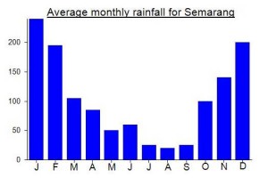
Local Average Monthly Rainfall (mm):
Location
Origins and Meaning
Lordly Mountain. Sindoro probably comes from the Javanese si (a kind of “title” or “person marker”) and ndara (pronounced /ndoro/) or bandara (pronounced /b’n.doro/) meaning “lord, master”. (George Quinn, 2011)
Great hike up Sindoro with spectacular views of Sumbing, Merapi, Merbabu, and Lawu to the east. Prahu and Dieng plateau and Slamet to the west. Logistics – we arrived in Jogja at 15:30 on Friday and a driver picked us up and we headed direct to the Dieng Kledung Pass Hotel (comfortable and clean). We’d arranged a guide, permit, and ojeks to/from the basecamp in advance. We got some sleep and at 2 am we were picked up by our guide and ojeks. we were hiking from “Pos 1.5” by 2:15 am. Steady progress, and we took 4 hours up and 2 hours down with time for wandering at the summit. A few great night views of Sumbing and Kledung after Pos 2. We reached Sunrise camp and Pos 3 in time for sunrise and had amazing views. There were a small group of Indonesian hikers at Sunrise camp, but they didn’t seem keen to head up to the summit early. We reached the crater at 6 ish and had the area to ourselves. We did the circuit (gases/fumaroles active but not problematic). It was pretty warm even in the early morning – just a light sweater required. We walked a little to the west for a great view of Dieng Plateau / Prahu and Slamet. As we started to descend, the Indonesian weekend hikers were on the way up. A steady stream all the way as we made out way to the base again. It’s definitely good advice to hike midweek or on Friday/Saturday as we did. The trail is VERY clean and in good condition. Really highly recommended hike. We paid 1 million Rp for the permit, guide, and ojeks for 2 people – expensive but everything was VERY smooth and our guide was very professional and a nice guy.
Climbed Sindoro on Thursday, 12-March-2020 via Sigedang. Hit the trail at 1am, returned at 12pm.
It was a great hike and I was lucky to catch a break in the weather. Between the amazing views of the Dieng mountains and the tea fields, I recommend this route. Going was slow: ~5 hours up and about the same coming down. The footing on this route is quite loose and extremely eroded, particularly from Pos 3 onward. This doesn’t really affect the ascent, but slowed the descent very significantly- coming down this mountain is much harder than going up, IMO.
Description of the trail is quite accurate, but here are a couple additional notes:
– Experienced motorbike riders should have minimal difficulty driving all the way to Pos 2, which is simply another tea collection shelter further up the stone road from Pos 1. Doing this will save only a small bit of walking through admittedly gorgeous tea fields, but depending on how exhausted you are following the hike, it may be an appealing option.
– While somewhat overgrown in spots between post 2 and 3, the trail remains easy to follow, even in the dark. I did not use a guide, nor do I think I needed one, except perhaps if the weather turned.
– Unlike some other mountains in Java were there is almost always someone awake at basecamp, the Sigedang basecamp building was closed when I started, so be sure to arrange a ojek to post 1/2 in advance, if that’s your plan.
– There is a clear path circumnavigating the crater rim, but hikers should take extreme care in some spots. There is a small saddle between the Sigedang route reaches the peak and where the Kledung route reaches the peak. The path along the crater rim is very treacherous in this spot and should be avoided via a very obvious detour that only takes an extra ~5 minutes. Other sections had significant gas that made it difficult to breathe.
Made my second trip to Sindoro this month – after a gap of over 9 years. Amazed at the changes to the summit area due to the volcanic activity. Got very lucky with the weather again and had tremendous views.
I decided to try reaching the area from Weleri train station. Although there are no executive class trains direct from Jakarta, it is possible to get the Argo Cheribon to Cirebon then hop on the Ciremai 2 / Tambahan for Weleri an hour later. I arrived in Weleri after midnight but luckily there were Grabcars available. It was Rp220,000 for the 50km, 1hr 20min ride to Bansari Kompas basecamp.
Upon arrival I was surprised at how few people there were, but this was very early on Saturday morning, so things are always quieter if you avoid Saturday night / Sunday morning. There was also an all-night wayang / gamelan performance going on nearby in Bansari village – beautiful to hear and sad that this isn’t much more common as it used to be in the past before the increasing Arabization of Indonesia’s culture. Gamelan – this is the real sound of Java, and it accompanied us for a few hours at the beginning of the hike. Apparently this was part of a 3-day festival!
We took ojeks up to Pos 1 and this definitely saved an hour or so (and 500m of ascent). As we started later than expected, sunrise happened when we were at Pos 4 Bukit Soma, and this turned out to be a good spot, with Merbabu and Merapi seen over the clouds, all framed in forest branches. Those first few minutes after sunrise are a delight in the forest, with bright red highlighting certain leaves and branches before succumbing to the bleach-out of full sun.
I was knackered by this point, having come straight from work in Jakarta, with little to no sleep, and found the final hour very tough going. Energy sapping.
There were no other hikers on the Bansari trail, but up on the rim were about 10 or so from Kledung. On our way down to Sigedang there were another 10 coming up. If you like solitude on Java’s 3000m plus peaks it pays to hike on Friday night / Saturday morning for sure. I didn’t get asked for a selfie once (until reaching Sigedang tea plantations!)
The only issue aside from the steepness of descending to Sigedang is getting public transport onward. It may be easier to get an ojek down to Wonosobo or up to Dieng, but I needed to get back down to Weleri on the north coast. As always, Grab is great from a town to a mountain but almost impossible from a mountain to a town. In the end, I got an ojek to the main road at Muntung then three sweaty little buses… first to Candiroto, then Sukorejo with its large roundabout, and finally down to Weleri, where I found very little to do except wait several hours in the train station for my train onward to Surabaya. If I did it again, I’d certainly start in the north in Weleri, but probably head south to Wonosobo afterwards, but perhaps transport and facilities will improve on the north side before long. It certainly beats trying to get to Pekalongan or Semarang.
By the time I reached Surabaya (after midnight and on the Jayabaya economy class train!) I was utterly destroyed due to lack of sleep and people trying to live chat with their friends whilst not-so-subtly videoing me, Mr Exhausted Bule, sitting behind them. I put up with all this for one strange reason… so I could fly back to Western Java the next morning using one of very very few flights to the large and currently not well used new West Java International Airport in Kertajati. Just to see what it was like. Very parched, empty landscape upon landing – must be one of the least populated low-lying areas in the province, and until they finish the toll road from Bandung it will presumably remain very quiet. From there, I got a taxi to Jatibarang (nearest station but harder to access than Cirebon as there is less public transport and very few ojeks) then back to Jakarta.
I had originally planned to hike Gn Kembang (Anak Sindoro) from Blembem, not knowing about the Lengkong route. After being asked for what I consider to be an excessively high fee (600,000) for a simple up and down from Blembem, from someone who said I would be unable to find anyone who would do it for 300,000 and then would not even reply to my pretty reasonable offer of 400,000 (because I was a foreigner and they were ashamed of charging a fair fee to an ‘outsider’ or because they simply won’t get out of bed for less than 600,000? – I don’t know) They didn’t seem very friendly so I half-considered not bothering with Gunung Kembang and just going straight to Dieng. Strange, especially when you want to promote their route online.
Thankfully, a bit more Googling and I found information on the Lengkong route and was told 300,000 – a fair price for six hours. The guys at the Lengkong basecamp turned out to be very friendly and serious about keeping the trail free of litter. Excellent.
From Purwokerto, I took a Grabcar to Wonosobo (under 2 hours – he was really speeding along the straight road near Banjarnegara!) About 3km north of Wonosobo on the Dieng road is the junction you want for Lengkong. It is easily identified just before a Hindu style entrance for the Dieng region, a statue of Pak Soehardjo Rustam (a former Governor of Central Java and also the Founder of Ambarawa Railway Museum), plus signs for Krakatau Homestay and an alternative route towards Semarang. From here it’s about 15 minutes by motorbike to the friendly village of Lengkong. In 2019, it’s Rp20,000 per person entry (same as Blembem) plus Rp5,000 for leaving a bike there. They check your bag to be sure that you bring down all your rubbish with you – and it seems to be effective as there is almost no litter to be seen on the trail.
We started at 2am (me direct from Jakarta straight after work with no sleep!) and we were easily up at the summit by 5am. If we had been walking quicker I’m sure 2 and a half hours would have been doable. It was quite a surprise how windy it was at the top – more like Scottish weather really and certainly the Scots would say it was blowing a hoolie up there. There were definitely more folk that had come up from Blembem, most of whom were camping, and whose tents were being buffeted by the winds. Wonderful views up here though. It’s a genuinely worthy additional hike to Sindoro itself, and the hills of Dieng look quite beautiful in the early morning.
We were back down in about 2 hours, with a brief stop at the paragliding spot. We then had coffee at Faturahman’s house and some getuk talas snacks. Not a bad place to live – perfect temperature and great views over the the Dieng hills, which is where I headed next for some local kentang goring and much-needed rest at Bu Djono’s.
Some terrible forest fires on Gunung Sindoro the past few days and possibly weeks (as if all the chaos in Sumatra and Kalimantan were not enough). Thankfully the Sigedang route is open as normal already – unsure about the Kledung route but quite probably still closed. Very much looking forward to a trip here next month…..assuming it is not set on fire by more irresponsible hikers in the meantime!
Yep. Was there 2 days ago and unfortunately I did not get this information in advance, not knowing where to find it. The Dieng Kledung Pass hotel said that the basecamp nearby was closed as of 22 September. Their English was not good but they seemed to suggest that it might not open again before the onset of the rainy season. I considered going up at night anyway. The risk looked very small risk given that the whole landscape is visible and absolutely no fires were to be seen. But no scooter was available to rent and I was worried about having enough torch battery for 4 hours of ascent in the dark, and I chickened out. Which I now regret somewhat.
Just returned from Sindoro, we climbed the Gunung via Sikatok. Having climbed neighbouring Sumbing we were running a little late and were to leave the Sikatok basecamp at 4pm. To save time our guide arranged transport which took us through the tea plantations to Pos 2: At 2127 mdpl. From here we started our trek at 4.20 pm, this route allows hikers to start at a fair height towards the summit. A short hike and just over an hour later after passing through the tea plantations the trail gets steeper at Patok Besi 2227m entering the forest area en-route to Pos 3 at 2530m. At 5.30pm we arrived at the camp site at 2530m, the site is small but has several sheltered flat areas to pitch tent. The campsite area has a clear view towards the Dieng Plateau below and Gunung Prau, Gunung Slamet and Ciremai are also visible to the left and Merbabu and Merapi to the right. The clear sky in the morning gave us great views of these Gunung’s in the morning.
At 6.30am we left the campsite enroute to the puncak/summit. Immediately the trail gets steep and due to the dry season weather it can get dusty but there is plenty of rock and scree for grip as the steep gradient allows for a fast and steady ascent. Ladang Batu and Pos 4 were reached in an hour. There is a false summit Ladang Batu at 3031m which we reached at 8.15am. At 8.30 am we were at the impressive crater and puncak summit at 3132m. The crater is very active and impressive in depth, and their is clear signs of a crater lake previously when the volcano was less active. The summit area is expansive and there is a crater rim which allows you to walk all the way around, and to the other side of Sindoro which opens up with a majestic view of neighbouring Sumbing, Merbabu and Slamet with Lawu lurking behind. The sulphur gas was ever present and constant so its best not to stay on top for too long, and by 9.30am the overhead sun is burning.
This is a great access route and having climbed in 2 hours from the campsite, it only took 1 hour to return to camp. Thank to our guide Pak Supri for showing is the route. The Sikatok route has not ben mentioned so not sure if it is a new route?
This is a great hike, and very accessible and offers 360 degree majestic view points of the volcanoes and highlands of Central Java. Combined with the well signed trail, good campsite area and easy access the tea plantations from Basecamp Sikatok, highly recommended.
Hi Simon. This is the same as the Sigedang trail. It apparently has two names. Funnily enough I have a plan to try it out in October. Looking forward to it especially after this report. Cheers, Dan.
Hi Dan do you know if this trail is still open. I heard bansari and kledung trails are going to closed soon. I have also planned to climb sindoro September end and now it seems to be closed:(
Hi Mayur. Normally they are closed from the end of the year but if there is a forest fire due to dry weather (or maybe a big risk) then it is possible. I still hope to hike up from Sigedang – probably weekend of Oct 19-20, with no camping, just hike up at night for sunrise at the top then straight back down. If you are interested then you are welcome to join me.
Hi Dan my plan was end of September and flights are booked. Actually i was going to 5-6 of them in 10 days like slamet, sindoro, sumbing, merbabu, lawu, raung but 4 in my list are closed. Thinking of any alternatives only to find nothing:(
Sindoro from Sigedang (in the north) is open as far as I know. Plenty of alternatives too.
I climbed Sindoro yesterday morning after climbing Sumbing the day before. I stayed at the Dieng Kledung Pass hotel right in the centre of the 2 mountains.
I left the hotel at 2am and rode up the stoney track for 2kms before coming to a kind of parking area just before pos 1. I parked here and started my hike. There was no one here at all when I arrived.
In actual fact you can ride the scooter another 2kms from here as the trail is mostly flat and very friendly for a scooter. You can ride almost the entire way to pos 2 and If I had my time over I’d do that.
The path up is quite steep with the last kilometre being at 40%. Poles make it much easier as it is very dusty and slippery!
From the scattered rocks at around 2700-2800m the sulphur smell was insane. The wind was strong from the south west so it was blowing the sulphur straight down the hiking path. I had to wear my buff and If I took it off the smell was too much to bear. My eyes were burning and i asked the Indonesian hikers if it was dangerous and they said no.
We gained the summit at 520am, around 3 hours of hiking up. I stopped for breakfast at 4am for around 15 mins.
The temperature wasn’t that cold and I almost didn’t need my jacket at the summit (I always hike in shorts and a tshirt) I’d hiked Lawu and Merbabu in the days before and they were much colder with ice covering the grass in certain areas.
Once at the summit you can escape the sulphur by simply going upwind. The summit area is quite big and really awesome. You can get different views and the Dieng Plateau on the west side looks amazing at sunrise. There is also what looks like a grave there with rocks covering it and some indonesian flags. There is evidence of 2 lakes but they are now dry. The crater has a huge hot spring inside that sounds like a huge jumbo jet about to take off. All the dead trees are also covered white from the sulphur.
The way down is very very slippery. The dust covering the rocks makes them like black ice. One step and you slide. I fell down probably 10 times even though i had poles.
From the summit to Pos 1 took me around 1.5 hours, stopping for many “selfies” along the way.
Sindoro is an epic mountain and certainly worth your time.
Distance 5 or 6km one way from pos 1 plus 1500m. My map and strava GPS gave 2 different readings for the distance.
Sindoro is very beautiful.
Took hours to get to its peak, but it was all worth it.
I climbed Sindoro yesterday and definitely agree this is a gorgeous climb! All the information was still correct. It is rather active, though, and care must be taken to stay clear of the huge Sulphur plume. In Europe or the US, it would never have been allowed to do this climb on your own. But as it was, I very much enjoyed it, leaving the starting point at 5:15 am, reaching the summit in 2 hours and 6 minutes, which was a bit funny as all the Sulphur-breathing students had taken 2 days….. easily doable as a day trip also when you are not a mountain runner. Make sure you go the (wide) round of the crater – the views of the Dieng Plateau and its Shangri-La like appearance are a highlight.
Sindoro is a very beatiful hike. It is easier and faster than Sumbing, which I found quite demanding for a day hike (compared to many other volcanoes in Indonesia). I needed 3.5 hours from pos 1 to the summit. Calculate with at least four hours. Spending the night on the mountain is not necessary because the tour is not so long (even if the mountain is a rather large one), but it possesses very beautiful camping sites. The gas emanations from the crater are very strong at the moment (April 2016). When I surrounded the crater area there was one part where breathing became quite difficult, and I watched out for possible escape routes (you always can go down a bit from the crater edge in case the gases are too strong). I saw Sindoro several times from the surrounding roads, and actually I noticed an increase in activity in the last time. The views from Sindoro are among the best you can have on Java. The trail is very well indicated, with a lot of signposts. And registration and ojek transportation to and from pos 1 is very well organized. And, good for foreigners, they have fixed prices, and they managed somehow that even the ojek drivers respect them. So no bargaining needed 🙂 I would say, Sindoro is one of the most recommendable mountains on Java (although maybe beaten by Semeru, Raung, and Selamet).
Hey Matthias,
I’m thinking of climbing Sindoro/ Sumbing this September and I can’t seem to find contacts online for a guide. If I can get to Kledung via bus will it be possible to get a guide there? Or is it possible to climb without a guide? Done a few hikes in Indonesia (Semeru/ Kerinci) and other parts of the world but so far always with a guide.
maybe i can help you on this issue. when i did sindoro i contacted the kledung pass hotel in advance and told them i wanted a guide and they organised it for me. all transport to kledung will know this hotel as you have to pass it and its probably the best and only place to stay.even just showing up there im sure they will have plenty of guides to find for you.make sure they include the ojek ride to pos 1 to save yourself a long walk on a cobbled road.you could do it on your own but i wouldnt.i didnt do sumbing but heard its way harder and to reach the actual summit you will have to do a bit of rock climbing and having someone else to give you a hand up is a must. so take a guide for that one
Hey Chris, thanks for the reply. Yeah, I’ll be more comfortable with a guide.Do you happen to have the contact?
no i dont have any guide contacts. i emailed the kledung pass hotel in advance and then in the end getting nervous that my guide wouldnt be ready i called them . in the end the worry of not getting the guide was unnecessary since they are plentyful in the kledung village. heres the hotel details if you want to get a hold of them in advance. DIENG KLEDUNG PASS hotel
Telp/Fax: (0286) 3322023, Mobile Phone: 081328119888
Email: diengkledungpas@yahoo.com
Here’s some info from a hiker who went up in June 2015.
“We went up about 2 weeks ago, the trail is signposted very clear with new bright orange signs.
You are not allowed to arrive at the summit before 7 AM as it might be dangerous (because of sulfur gas still trapped in the crater). After 7 AM the sun heats up the gas so it can escape.
And the regulation is to start your decent 12 noon the latest to prevent clouds coming in and obscuring the way. Fee is 10 000 per person, we did not take a guide.
And as far as we saw there is no water all way up.”
Climbed Sindoro last night. Started at around 12am. Those pressed for time can also take an ojek all the way up to Pos I from basecamp (Rp 15,000). Went solo, without a guide, fully prepared for the rain to greet me near the top, and boy it did! Nevertheless, one of the most complete treks in Java. Has a little bit of everything from flat jungle treks to steep climbs, vast savannahs to stony surfaces near the top. The summit is out of bounds before 7am and after 12 pm due to an increase in release of toxic gases from the crater. Pretty straightforward trail, clear enough for the solo hiker. Although it is a good idea to read up about the place as much as possible beforehand. The information here is indeed helpful. Plenty of information at the basecamp as well so do make sure to study it well before starting the trek. Pos III to the summit takes a lot longer than you think. Despite a difference of only 600m in elevation from Pos III to the summit, Pos III is just a little above halfway up the trek. If camping overnight at Pos III, a good idea to start at around 2.30 if in a big group or 3am if its just the two or three of you. I made it to Pos III from Pos I in about 90 minutes where i took a break for another 90 minutes as i didnt want to reach the summit too early for obvious reasons. Watch out for strong wind and persistent rain which could have disastrous effects on you if you don’t come prepared. A lot of people don’t end up reaching the summit because of this, and turn back from the 2nd hutan lamtoro, above batuh tatah (edelweiss forest or so i believe).
A couple of things to remember:
– Between Pos II and Pos III, you will come across a large stone with some writing scribbled all over it, climb above it and you should see another large stone with some writing on it with 2 paths that look like the trail. Take the trail on your left and you should be okay.
– On your way from Pos III to the summit, always keep right. There will come a point where you will have a lot of paths that look like the trail you’ve been climbing so far. Keep as right as possible. One of those trails lead you straight to ‘Jalur Buntu’ which is basically a forest area growing javanese edelweiss on it (a lot taller than the usual shrubs you come across on your trails. There is no access to the top from here. You should be able to see it on your left while climbing up the right trail, somewhere near the summit.
Views from the top are spectacular towards Sumbing where you can catch Lawu, Merbabu and Merapi on a clear sunrise. Sumbing’s magnificient presence can be felt throughout the climb. A beautiful blend of red, orange and golden dominate the skyline behind Merbabu and its neighbouring mountains. A good idea to wait for first light at around 4.30-4.45 am whichever part of the climb you find yourself in, assuming you’re well above Pos III of course. It will make for a truly memorable experience.
Be safe, be good and enjoy Sindoro, it makes for a fantastic adventure.
Far from being long-dormant, Sindoro is in fact as full of vim as a butcher’s dog. We were forbidden to see sunrise at the crater, because the gases are too lethal. According to our guide Rizal, Sindoro has been erupting since 2011 and a man died while camping beside the crater in 2013. This naturally made us wary of attempting the summit at all, but Rizal assured us we could do so if we waited until after 7am, when the sun’s warmth has helped to neutralize some of the gases.
Accordingly, we set off at 1 a.m. from the tobacco plantation, reaching Pos 3 at 3 a.m. Sulphur can be smelled at some points, but was not disturbing. By 5.30 a.m. we were in position at a lookout spot just above 2900m to enjoy the sunrise. The view south from here toward Merbabu and Sumbing is awesome, and effectively the same as one would see from the south edge of the crater rim.
At 6.30 we resumed our hike, reaching the crater after another hour. There is no longer any water in the large crater, just fumerolles blasting sulphurous gas high into the sky. It is still possible though to take a pleasant tour round the rim and visit the grassy camping area, with its small grave. A simple, cloth anti-pollution mask, sold in shops in Kledung village (mainly for motorcyclists), helps take the sting out of the gases. Camping or descending into the crater would be foolish, but old messages formed from rocks can still be seen on the shelf at the southwest corner of the crater. From the northwest side one has a view of Gunung Prahu and then a line of mountains westward as far as Slamet.
GPS height maxed out at 3162m at 2 separate points on the rim.
Descent took 4h30. Kledung Pass Hotel is nice, but Warung Joglo restaurant, 2km west of the hotel, has better food.
I was born and grow up in Wonosobo, and, Sindoro is the first mount that I climb. So glad to find this website, but I found a little mistake in the map above, the name of place at the north of Mojotengah is not “Garungan” but”Garung”.[Please ignore my poor English, he he..]
I’m looking at bagging some Indo peaks and this looks like a good one to start with, just have some questions
1. Is the trail/route easy to follow?
2. How much would a guide cost?
3. Could I leave a bag w/ unessential things at the Kledung Pass Hotel, and how much is it per night?
Thanks
1. yes
2. 300,000
3. probably and 250,000 a night (ish)
Thanks! Also forgot to ask; Are guides are mandatory?
Im planning to bag Sindoro on November 24th. I’ve contacted Ragil and he’s available. Anyone interested in coming along? Im coming from Semarang on the Saturday morning to do the overnight climb. Or if anyone has any thoughts or advice on climbing this close to the rainy season, id love to hear it!
i summitted this great one last week and it is open for hiking.at least it was if you call the kledung pass hotel in advance to organise a guide. through other scources i was told it was closed due to the extended dry season.
dans description is right on.not much to add except if you have a choice of flying to semerang or yogya , id be trying yogya. the road from semerang is very slow with lots of turns. never have i felt so carsick.and that was me trying to be smart and take a taxi instead of the bus.kledung pass hotel is ok.nice people there. not sure about the fly ridden food in the restaurant out the front but theres no other option for food.
as i said the hotel will organise a guide.defianetly get a ojek up the cobbled road.that will save a hour of boring walk.
i made the rookie mistake of setting off to early ( 10.pm) and arrived near the summit at 3.00am which gave me a freezing 2 hour wait for the sunrise.theres quite alot of bubbling water and gas coming out of a small lake in the main crater.views to sumbing,merapi and merbabu are spectacular.i wouldnt mess around too much at sunrise because you are looking right into the sun on the way back down and theres no shade.this was the first of 3 mountains i climbed this last week and this one defianetly gave me the most knee problems.the other 2 being merapi and lawu.i was supposed to do sumbing the next night but with my knee hurting and the guide freaking me out over how much harder sumbing is( he was very adament that you couldnt bagg it even though i know dan has done it) and also the thought of hanging around in kledung made me head off looking for a starbucks.
saya lahir&besar di kertek,waktu kecil ingin sekali naik ke atas sana,pada usia ku ke 15 aku dan 21 rekan ku mendaki sindoro,tapi hanya 4 termasuk saya yg sampai ke puncak,waktu itu terang bulan,jadi sepanjang pendakian ke puncak sangat menyenangkan,terang dan sangat indah,di saat itu lah ku sadari betapa AGUNG dan INDAH NYA CIPTAAN TUHAN,kami mulai mendaki jam 9 malam sampai di puncak jam 2pagi,dari atas saya dapat melihat matahari terbit,dan hamparan ilalang yang indah di tiup angin,waktu turun di sepanjang jalan berjumpa dengan warga setempat yang sangat ramah,dari puncak SINDORO,KE PUNCAK SUMBING,menjadikan aku pendaki TANGGUH,sekarang saya 34th,dan tinggal di SABAH MALAYSIA,kini saya bertekat menaklukan GUNUNG KINABALU,saya yakin saya bisa!!!!…
Salam lestari, saya juga lahir dan besar di Wonosobo Mas[Sambek], sekarang saya 38th dan tinggal di Cikarang, Bekasi. Tapi Sindoro adalah gunung yang pertama saya daki dan paling sering[7 x summit], dan dari Sindoro saya belajar menjadi kuat dan pantang berhenti sebelum puncak. Umur tidak menghalangi untuk mewujudkan impian2 yang sempat tertunda, untuk menapaki beberapa puncak gunung yang dulu belum sempat dikunjungi.
Experience the north and south slopes of G Sindara by ascending from Sigedang and descending to Kledung. Not the opposite because the Sigedang trek is extremely steep the last 3 – 4 hours. Scary to look back. The view to the north is beautiful although not spectacular. Sigedang route is not frequented by hikers, you could have the trek yourselves.
Ragil (081328096081) lives in Kledung and knows both routes well. He is just excellent.
I had the pleasure to finally summit this mountain on the 5th of April.The night before there was a substantial earthquake in Cilacap.Needless to say it shook the house I was staying in Wonosabo, and made me think that Sundoro was reawakening from a long slumber. The info above is accurate, byt Sundoro is a big mountain and by no means a walk in the park. Although we made it to the summit in about 5 hours or a little less excluding the water breaks. The descent took a little longer than expected (Slippery,loose rocks etc.) Although, the way up I kept thinking this is one of the most enjoyable trails I’ve done in Indonesia. At 10,000 feet the views are superlative and a potent reminder of the spirtual connection the Javanese feel with the aera. If Yoga is the epicenter of javanese culture. Wonosabo and the Dieng plateau is its heart and blood.
I climbed it last weekend and it was suprisingly long! We hiked from Kledung Pass at 9Pm and didn’t get there till 3:15am.. but the top is amazing! We swam in the lake. Oh and it’s really cold at the top esp. if it rains, so bring enough clothes and a towel to dry off from the rain and lake
great reports dan.do you think its necessary to have a guide . and how do you rate my chances of making the top considering my parang meltdown.
For a 3000+ it’s pretty straightforward. You’d probably have cloud during the day so I’d take a guide, climb at night in time for dawn.
i’ve been there, but never reach the top!!