Facts
- Elevation: 3,440 m (11,286 ft)
- Prominence: 3,440 m
- Ribu category: Sangat Tinggi
- Province: Sulawesi Selatan (South Sulawesi)
- Google Earth: kml
- Rating:


 (10 votes) Add your rating
 Loading...
 - Other names: none.
Photos


Bagging It!
This Ribu is the highest peak of the vast Latimojong mountains in the northern part of South Sulawesi and also the highest mountain in all of Sulawesi. It is almost as much of an adventure reaching the start of the trail as it is actually climbing to the top! For its great height, it is relatively unknown and is easily one of the least-climbed large island highpoints of Indonesia. It takes a long time to reach the start of the trail – a full day driving from South Sulawesi’s capital Makassar to the village of Gurra (via Pare Pare which is a good place to stop for lunch). Look out for the eccentric and amusing motor-becaks on the outskirts of Makassar!
The village at the trailhead is Karangan (at approx. 1,415m) and the muddy track to the village from Gurra is very rough, potentially dangerous and occasionally unusable. It is best if you arrange beforehand to be taken up to Karangan in jeeps/4WDs from Gurra – outdoor trekking companies in Makassar are your best bet to sort it out for you otherwise local ojeks should be available for smaller groups. This part of the journey alone will take nearly 2 hours in good road conditions, but it is certainly memorable!
It will probably be dark by the time you reach the friendly hill village but if you take porters from there you can stay overnight there and get well-fed. On the trail itself you are unlikely to encounter many fellow hikers due to the remote nature of the mountain. There are one or two steep and challenging sections (especially between Pos 2 and 3) but the flora and fauna should be enough to keep you motivated. The forested areas are covered in beautiful mosses – probably very rare species indeed. In clear conditions there are good views to West Sulawesi and the coast.
The trail leads via Pos 1 Buntu Kaciling (1,750m), Pos 2 Goa Sarung Pakpak (1,864m) where there is a river, Pos 3 Lantang Nase (2,020m), Pos 4 Buntu Lebu (2,250m), Pos 5 Solo Tama (2,600m) which makes a good alternative camping spot but has no water source, and Pos 6 Buntu Latimojong (2,835m).
There are plenty of campsite areas higher up (especially at Pos 7 Kolong Buntu at 3,200m) and a small lake (3,260m) just below the summit col. It is fairly cold at night up there – remember to take extra layers of clothing and waterproofs as it usually rains by late afternoon. Sunrise is the best time to admire the views from the summit pillar – the views over the sea to Southeast Sulawesi are particularly fine.
Note that there is some debate over the exact height of the mountain. Estimates range from 3,440m to 3,478m and the lower figure appears accurate based on GPS data and Rantemario is definitely the highest peak in the range (despite talk of nearby top Rante Kambola being higher).
The second highest peak in the range is Buntu Nenemori, a couple of kilometres to the south-east of Rantemario. The Bakosurtanal map suggests a height of 3,397m, but satellite readings mean it is likely to be a little over 3,400m. The peak that gives its name to the entire range, Buntu Latimojong (3,305m) is a around 5 or 6 kilometres further south-east of Nenemori.
Head back down the same way to Karangan for a night and then back to Makassar the following day.
Bagging information provided by Daniel Quinn
Trail Map
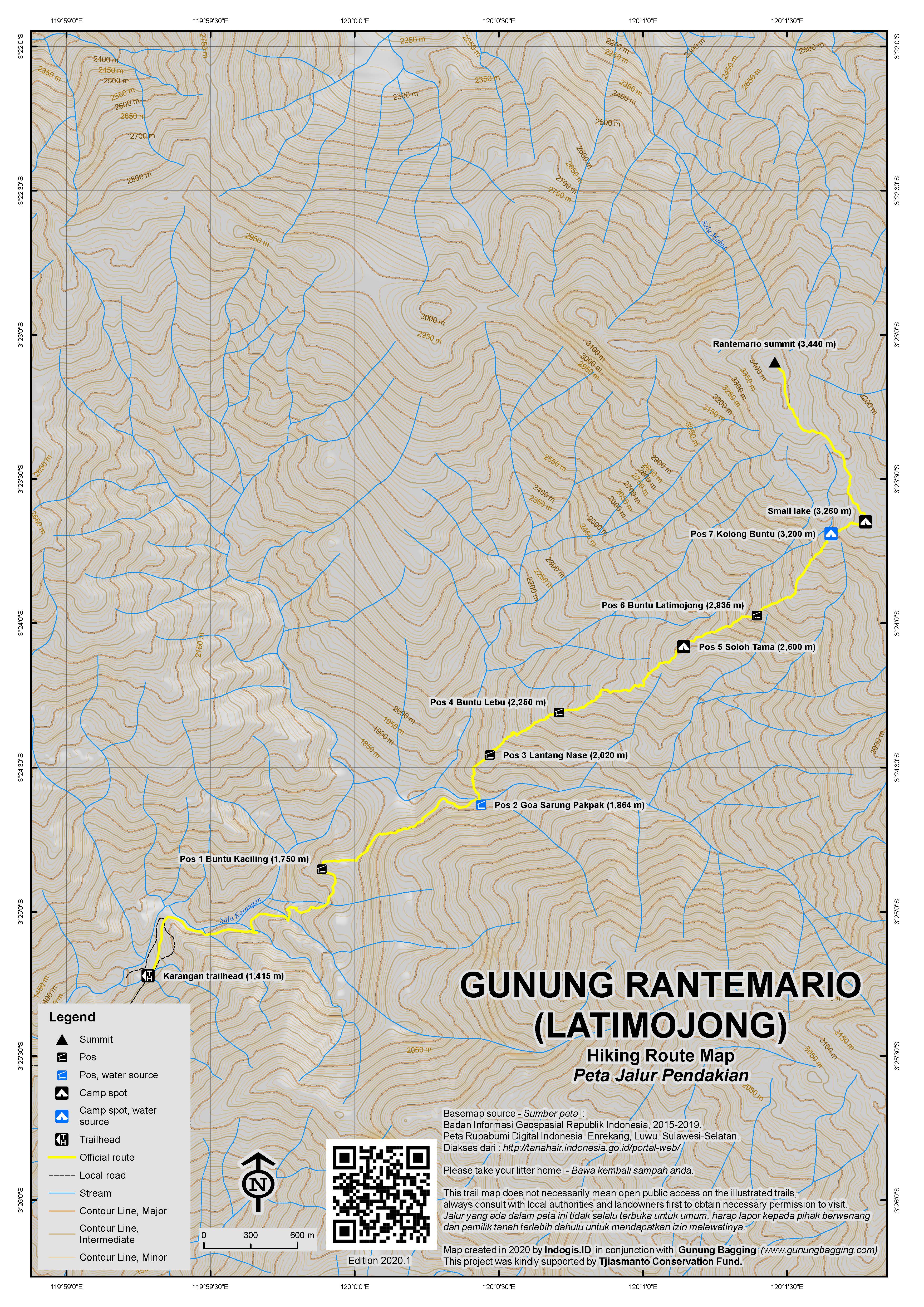
For a high quality PDF version of this and other trail maps, please download from our Trail Maps page.
Local Accommodation
Featured Guides
If you are a reliable local guide and would like to be featured on this page to increase your bookings, or a tourist who would like to support the development of a local guide business, please email danpquinn@gmail.com with the following information: Mountain name, guide name, guide location, guide contact details, and at least one English language review from a previous hiker who was pleased with the guiding services. An example is given below for reference. We have a maximum quota of 3 featured guides for each mountain page on the site. The fee for this is £20 (British pounds sterling, typically via the Wise app or PayPal) for a period of 1 year and helps to pay towards the ongoing development of the Gunung Bagging project.
- Name and location: Pak Budi, Surabaya, East Java.
- Contact details: +62812xxxxxxxx, budi@gmail.com, https://www.instagram.com/budi_mountain_guide/
- Review from previous client: “Budi was a brilliant guide for our September 2023 trek up Gunung X and I would definitely recommend him to other tourists“, John, USA.
Practicalities
- Getting there: It takes a full day to reach Karangan from Makassar by car/jeep. Daily buses from Makassar to Toraja leaving at 9am and 9pm.
- Guides and GPS Tracks: Want a PDF version for your phone? Looking for a guide? Need GPS tracks and waypoints? Gunung Rantemario information pack can be downloaded here.
- Trip planning assistance: Would you like Gunung Bagging to personally help you in arranging your whole trip? Please contact us here.
- Permits: Not required at present – take a photocopy of your passport photo page just incase.
- Water sources: Available at Pos 2 and Pos 7.
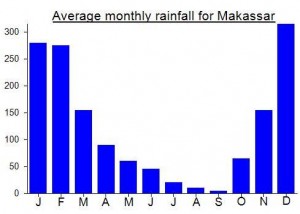
Local Average Monthly Rainfall (mm):
Just got down from a very very cool trip up Rantemario. It’s still remote but seems like it has gotten a fair bit more traffic since the Gunung Bagging team’s visit.
To get there, it’s a 6 hour drive from Makassar to the town of Baraka. That’s just a bit off the main road to Tanah Toraja so transport options are OK. Travel vans do the route several times per day. The road from there to Karangan is now paved the whole way, though still incredibly steep so you’ll need either an ojek or 4WD. These can be arranged in Baraka without much trouble, and the ride takes about 1.5 hours through stunning rural mountain landscape.
When you get to Karangan there are various places advertising outdoor adventure and you can arrange guides etc or a place to stay there. The trailhead itself is located just beyond Sivin Camp, which is set in a narrow valley around a lovely river and is probably the most beautiful campground I’ve seen in Indonesia, offering tent sites and cabins and general rural Indonesia hominess.
The trail seems basically as described above, but there are steady streams of hikers now. Nowhere near as busy as the major Java mountains but enough people to pick up the odd hiking companion and have a good chat now and then. Most people camp at either Pos 5 or Pos 7. From the trailhead, it took us 4 hours to Pos 5 and then another 2 hours to Pos 7. From there to the summit is 1 hour. Some other people were doing it as a day hike, which is just about possible if you leave before dawn. The trail is well maintained and easy to follow. Simaksi is 25K for people with Sulawesi KTP, 50K for other Indonesians and 150K for foreigners (including KITAS holders). They have a number of rules about hiking the mountain – some common eg about trash, but others less common, including that women on their period may not hike and people sharing tents must either be of the same gender or show a marriage certificate when registering.
We camped at Pos 7 which was stunning. It has a perfect view for sunset, and the clouds cleared for us just for an hour right around sunset giving us maybe the best sunset views we’d ever seen. We reached the peak before the sky started getting light and again the clouds cleared for just long enough for us to see distant lightning shows and a stunning sunrise before packing in again right after the sun came up. Unbelievable luck in the timing but both sunset and sunrise views were spectacular.
I’d recommend using local guides from Karangan itself. Several locals told us they’ve had problems with guides based elsewhere (like Makassar or Rantepao) not respecting the mountain and not paying the locals what they believe had been agreed. Obviously I can’t comment on those disputes but I will say that (1) when I was looking for a guide, I had a few oddly tense interactions with guides based in other parts of Sulawesi regarding prices and schedules, and (2) the people I dealt with in Karangan itself were extremely welcoming and helpful and keen to put their mountain on the map (noting that not much English if any will be spoken). It’s also quite a wild and rugged area with massive cultural differences across very small geographical areas, so probably best for all to try to use very local services as much as possible.
Hola…if You need any infornation or need a Tour Guide to hike to This Mountain,send me a line via Whatsaap +6285298361065 or email : inomayana@gmail.com,
I work as a Licenced Tour Guide in Sulawesi and based in Tana Toraja..
Warm Regard
Ino
Is it possible to to summit the mountain and return in a day? We are both very fit and experienced hikers but i can’t seem to find the distance to summit?
Is a mountain permit or guide required for this?
Thanks
I did it back in 2009 so that’s why the write-up is not as detailed as most of the others. Haven’t heard of anyone completing it in a single day. Guide highly advisable – they don’t like it if you don’t contribute locally in that way. Unless things have changed you don’t need a permit but do need to register (i.e write your name down in a book in the village and give them a small donation).
Bisa dengan trail run bosku,,,,, awal ramadhan kemarin saya kesana,,,, start jam 7 pagi base camp di karangan,, tiba kembali di basecamp jam 7 malam
jika ada yang ingin ikut trip ke gunung latimojong dan pulau dutungan pada tanggal 18-23 maret anda dapat daftarkan diri dengan cara menghubungi nomor ini: 082193028944 atau kirim lewat email @aminghamire12@gmail.com
Anyone want to ask about climbing to Rantemario, you can contact me and i can help you about the trip.
Thanks regards..
Pls email duration n price for 2 person climbing 31Aug-3Sep. Makassar n back… rush but we can move fast.
Tth_2k@yahoo.com
Ok, i will send you, or may you have whatsapp?. Please chat me to +6282189282666. Thanks
I am going from 1st of may 2016, anyone interest to join?
Hello , i am planning to climb /hike Mt. Rantemario on 12 July 2015 with any group, looking forward to updates and info./itinerary soonest, thank u
Hi All,
Please visit our website for more information about Trekking to Rantemario Summit http://www.indoglobaltours.com/tours-destination/sulawesi/rantemario.html.
We have been handling many guest trekking to the Rantemario Summit. Please feel free to send us an email if you have any question at info@indoglobaltours.com.
Sincerely,
Hernan Halim
hi, i’m from malaysia .
i wish to hike rante mario.
kindly advice the best guider and services offered starting from aiport. or any advice that should i know.
thank you for the advice mas handjono.. in february i finish my assignment in sulawesi :))
February will be rainy, it would be quite tough overthere. Also, you would miss the best views.
im planning to go to rantemario around february 2014, any advice or suggestion?
Hana, you can contact Dadang at Barakka (0813 549 769 76) or Hax at Kalosi (0852 998 702 23). There was no mobile phone signal in Karangan (the last village).
Thank you so very much! Really appreciate the help 😀
Anyone interested in climbing this 22nd Nov 2013?
Hana you want to make sure the weather is good by Nov. 22. On the way up, the trek approaching Pos 2 (the waterfall) is very treacherous. It is quite levelled but very narrow, slippery and unstabile. On the way down, the trek approaching Pos 2 is also treacherous. The descent is almost vertical although very short. Be very careful if it rains.
Oh thanks for the advice Handjono. Do you know where I can get a guide because I would be going there on my own? I will check the weather. If I cannot climb it, I will climb other mountains on the island. Thanks 🙂
Good morning Dan, we just returned from Rantemario and for a change your report of th climb is rather miss.leading. I have done many climbs throughout Indonesia and this is one of the toughest ones. There are several sections especially around Pos 2 which arenverybdifficult and rather dangerous . You must mention that there are actually 2 ways to reach the summit. We did probably the new route which is a totally different adventure. The easiest part of the whole climb is the trek from the camp up to the summit.
To reach the base village in one day is a huge challenge. The final 20 km to the starting point took us over 3 1/2 hours on motor bike. It would have been of great help to have the GPS treks. Keep climbing and best regards.
Let us know how you get on with Tonggongkarambu.
Users of public transport out of Makassar need to get to Terminal Daya on the north side of the city (the same side as the airport).
The big Metro Permai bus to Toraja leaves at 09.00 (officially, actually more like 09.30). There’s also an overnight bus at 21.00. You’ll pay the full fare- Rp95,000 to Rp115,000- even though you’re getting dropped off in Cakke, about 7 hours along the route. A Panther (shared taxi), also available at Terminal Daya, would be cheaper (Rp60,000), but hotter and less comfortable.
From Cakke it’s 30 minutes by ojek to Barakka, where you can get another ojek, or relay of ojeks, for the 2 hours via Gura, Buntu Mondong and Temolo to Karangan. If it’s late or pouring with rain, there’s a penginapan in Barakka. There are also said to be hardtop jeeps from the Barakka market to Karangan if you wait long enough.
Until you get to Karangan itself, three’s no point telling anyone you’re going to “Gunung Rantemario”, which nobody has heard of. “Latimojong” might ring more bells.
In Karangan, check in with Pak Sinu, a senior figure who can offer bed and board and arrange porters for Rp150,000 a day.
Hiking from Karangan, we spent the first hour in coffee plantations, then 6 further hours to reach Pos 7 on a forest trail of variable difficulty. The toughest sections are before and after Pos 2, where the trail winds along the side of, and then steeply up from, a narrow river valley. The riverside Pos 2 is a great place to bathe. There’s also a fine bathing pool just downstream from Pos 7; it’s breathsnatchingly cold though.
GPS altitudes were as follows: Pos 2 1864m, Pos 3 2015m, Pos 4 2241m, Pos 5 2598m, Pos 6 2824m, Pos 7 3197m.
After camping at Pos 7, which has space for a dozen tents, we set off at 04.30 for the summit, reaching it at 05.40, just after sunrise. The trail splits just after Pos 8, but merges again later.The summit altitude reading was 3,440m, identical to the Nelles Sulawesi map figure, but 38m less than marked on the Periplus map.
Weather at the end of October was overcast. We had a few light rain showers but the cloud blanket certainly helped to damp down the icy gusts at Pos 7.
Descending from Pos 7 to Karangan took 6 hours; it actually took longer getting down from Pos 3 to Pos 2 than going up! I wouldn’t recommend climbing Rantemario as a one-day round trip, given the treachery of some of the descent sections.
After a meal of rice with cow hide and a pleasant sleep in Karangan you can get an ojek directly to Cakke the next morning. Most buses or Panthers coming from Toraja will have empty seats to bring you back to Makassar.
Despite its remoteness and cruel ascents, unfortunately G Rantemario has seen garbage and graffiti. Water everywhere, be very careful when approaching Pos 2 for its treacherous trek. Also when descending from Pos 3 to Pos 2, for it is very steep. Can not rate the view from the peak because we did not see anything further than 10 meters at the peak. There was a 50 knots storm that lasted many days around the peak. Hopefully no one would experience that kind of storm anywhere.
Anybody going to G Rantemario before March 31, 2012?
Thanks for an inspirational and informative site! I’m thinking to hike Rantemario 23-26 November. Is anyone interested to join me? Or got a recommendation for a guide?
fyi, you can join with SAR UNHAS Team (Search and Rescue Hasanuddin University), Makassar, South sulawesi), they provide much information about the mountain, and they will guiding you to reach the mountain.
Is there anyone knew that this site very interesting> Imagine, I was botanist and I have recorded more than 20 species flora in this mountain are endemic to Latimojong and Sulawesi including whole Rhododendron that you never seen in any place.. Great..
For Indonesian speakers, the book “Jelajah Lima Puncak Sulawesi” has a reasonable enough pos-by-pos description of the track. The airport bookshops in Makassar generally have a copy so you can pick one up as you arrive. It’s a thin book too so easy to take up with you for the hike.
in 2000, i have reach seven summit in latimojong mountains, Rante Mario is tallest. Start from Rante Mario, Rante Kambola, Pokah Pinjang, Nene Mori, Buntu Sikolong, Lapande and finish in Sinaji Mountain in Toraja land, all in 15 days, nice adventuring.
good job… all information on this website very usefull and thanks to promote Indonesia’s mountains tourism…