Facts
- Elevation: 2,423 m (7,949 ft)
- Prominence: 1,967 m
- Ribu category: Tinggi Sedang
- Province: Sarawak (Malaysia)
- Range: Kelabit Highlands
- Division: Bahagian Miri and Limbang
- Google Earth: kml
- Rating:

 (5 votes) Add your rating
 Loading...
 - Other names: none.
Photos


Bagging It!
Mount Murud is the highest peak in the Kelabit Highlands and, indeed, the highest peak in Sarawak. It is part of the recently-created Pulong Tau National Park although at present there are no significant Park facilities or anywhere near as many travellers as you would encounter in Mulu National Park. However, with incredible flora and fauna, stunning rock formations, unbelievable panoramic views, and ample shelters to make carrying a tent with you quite unnecessary if you hike from Ba’kelalan, this is one of the finest hikes in Borneo, if not the entire Malay archipelago.
The first known successful ascent was in 1922 by Dr. Eric Mjoberg, a Swedish naturalist and then curator of the Sarawak Museum. Another curator, J. C. Moulton, had tried and failed twice previously to reach the summit in 1914 and 1920. Since 1985, Murud has been the ‘venue’ of an annual Christian prayer pilgrimage organised by the International Revival Meeting, and it is this large collection of simple wooden houses high up the mountainside known as ‘Church Camp’ that makes finding shelter very straightforward indeed.
There are two main routes up the mountain, and although getting to either trailhead is quite difficult, there are regular flights from Miri to the highland towns of Bario (sometimes mis-spelt Bareo) and via Lawas to Ba’kelalan (sometimes mis-spelt Bakalalan). Despite its considerable height, the mountain is not climbed regularly and, without local contacts, arranging guides can be difficult and time-consuming (especially for solo travellers) unless you want to pay a premium by booking an expensive tour online in advance.
Both Bario and Ba’kelalan are very close to the Indonesian border and there are actually permitted trekking routes which cross over the border (but you are not able to get an official Indonesian visa here and must return to Malaysia afterwards). The eastern slopes of Murud itself are technically in Indonesian territory although the regular trekking routes do not pass by here. In 2018 it appears that the authorities are not allowing foreign nationals to cross over the border for tourism purposes.
Anyone interested in pitcher plants will adore Gunung Murud as there are a large number of species alongside much of the trail. These include Nepenthes murudensis, muluensis, lowii and hurrelliana. Apparently September is a particularly good time to see rare orchids in bloom on the mountain.
Looking at the map and the basic facts, Bario (1,085m) really ought to be a better starting point as it is the largest town in the Kelabit Highlands (and even then more like a village) so you would expect there to be more potential guides available. However, guides are very few and far between, and you may need several spare days to find reliable and knowledgeable local guides who are actually available for what is a multi-day expedition.
The much better starting point is actually Ba’kelalan (920m), a smaller town than Bario but actually much better for getting to the top of Gunung Murud. Gukang is a recommended local guide who is very experienced, speaks good English and in 2018 charges RM150 per day for his services (not including food and transport).
If you a considering a traverse do bear in mind that whether you start in Bario or Bakelalan, if you are not returning to the same starting point, you will have to pay any guides and porters an extra two days of wages for the time it will take them to walk back from Bakelalan to Bario (or vice versa). For most single hikers – or even many small groups – this can put considerable strain on one’s budget. Groups of 4 or more are likely to find a traverse of Gunung Murud more affordable and within one’s means.
Bario-Murud summit-Bakelalan (or vice versa) can be done in 4 full days but you will need a minimum of six free days to allow for flying in at one end and flying out at the other and 4WD will be needed at at least one side.
The following is an account of the simplest, quickest and cheapest way to get to the summit and back which is from/to Ba’kelalan. Apparently, the population of the Ba’kelalan area is 1200 across 13 villages, the largest of which is Buduk Mur next to the airstrip with 300 people. Day Zero is reaching Ba’kelalan (via plane from Miri via Lawas (three times a week) or Bario (once a week) or else via 4WD from Lawas) and Day 4 is back out to Miri and onwards home. Therefore you need 5 days from/to Miri or possibly KL depending on flight connections, 3 of which are hiking days.
From/to Ba’kelalan:
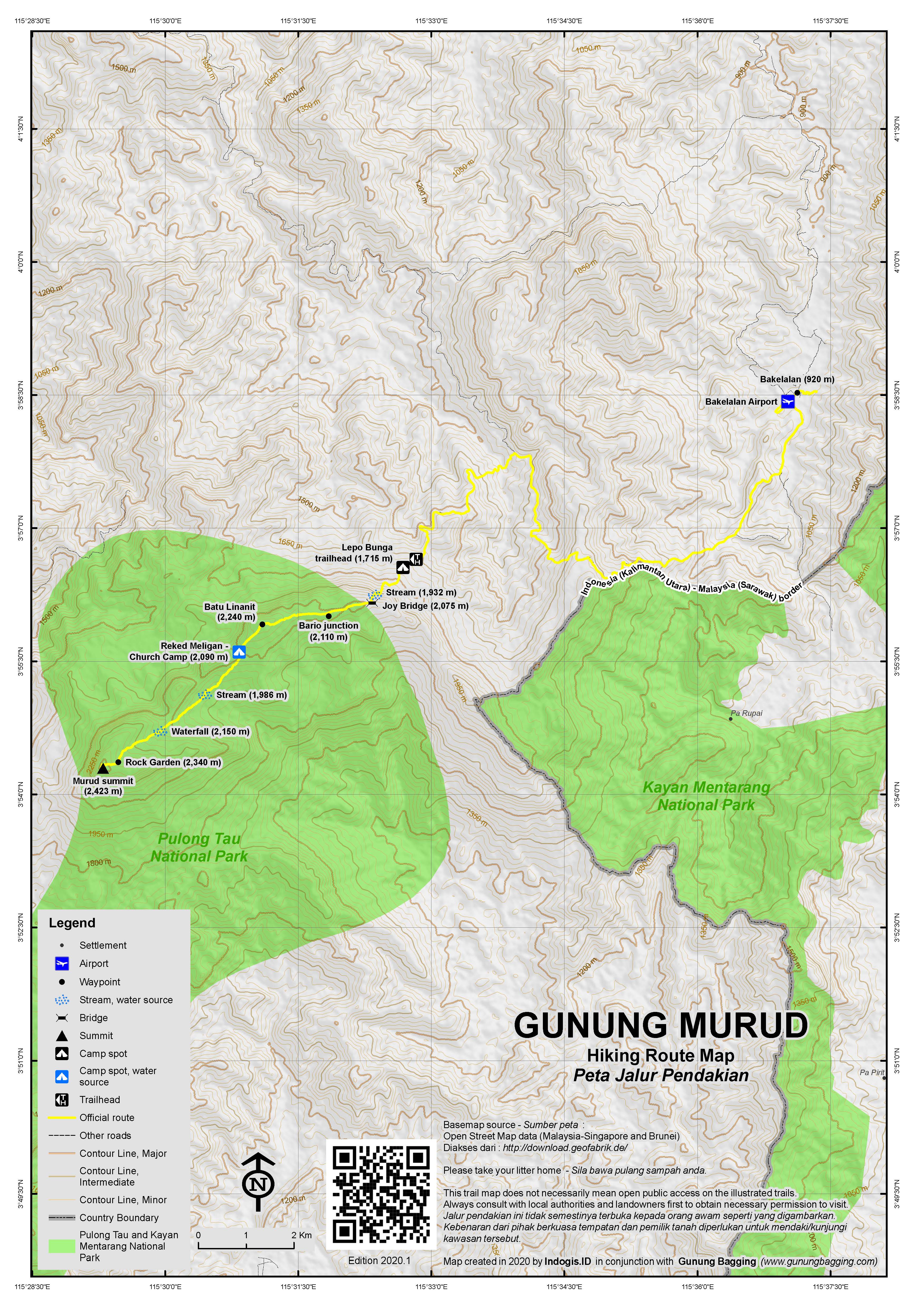
Day 1 – Ba’kelalan to Church Camp via Lepo Bunga (4-6 hours or 8-12 hours if not using 4WD)
If not using 4WD (which in 2018 costs a hefty RM350 for the one-hour journey to Lepo Bunga but will fit in a large group if some are willing to sit in the back of the truck) then you have a long day ahead of you with several hours of trekking along wide tracks in potentially direct sunlight. From the Ba’kelalan airstrip you need to take a left (not right to the sign for Lawas) and then pretty much all the next turnings you need to stay right. Eventually you will reach the dead end at Lepo Bunga (1,715m) where there are three wooden houses.
These wooden houses were constructed by the National Park authorities just a few years ago, yet have by 2018 already turned into accommodation for hundreds of swallows who have built nests everywhere inside, even in rooms with framed photographs in them! Nevertheless, should you have a problem with transport then these shelters will be acceptable for a night. The views here are quite nice as you are already quite high up.
From Lepo Bunga, a trail leads into the forest and is at first quite wide. However it soon narrows and gets progressively steeper, with some tricky narrow logs that are used as simple notch-cut ladders. In 90 minutes of less you should have reached a ridge known as Joy Bridge or Jambatan Sukacita (2,075m). This is a great spot for a short break and there are lots of beautiful pitcher plants from this point on. It is also where the old wooden walkway to Church Camp began. This has rotten over the years and is slowly being replaced with more durable metal sections of trail. The old wooden sections that remains are in various states of disrepair so take extra care and stay near the centre of the wooden walkway sections.
The easy-to-miss junction with the Bario trail (2,110m, on the left) is less than 30 minutes after the start of Joy Bridge. Another 30 minutes and you will be at the foot of a steep wooden stairway (2,175m) with a sign for Reked Meligan (Church Camp) at the bottom of it. From this point, the views open out and after just 15 minutes you will reach an airy top known as Batu Linanit (2,240m), which means ‘uncovered’ or ‘peeled’ rock, as this stone was cleaned of mosses by local people.
The panorama from atop the rock is superb. A few kilometres away is Gunung Murud, down to the right of which is Batu Lawi, and further right it is possible in clear conditions to see Gunung Mulu, the second highest peak in Sarawak. Looking back down from the way that you have ascended you may be able to make out a peak with some bare rock showing in between the trees. This is the highest point of the new road connecting Ba’kelalan with Bario which is still under construction.
From Batu Linanit, the trail leads down to Church Camp (2,090m), the usual place to stay before making an attempt on the summit the following morning. It takes less than an hour to descend to Church Camp which is ‘holy ground’ or ‘Reked Meligan’ to local people. There are about 50 simple wooden houses and two churches – the old one ‘gereja lama’ and the new one with ‘haleluyah’ written on the side of it. There are also two separate toilet blocks those these are still simple and you normally need to collect water for flushing from the streams. From near the new church there is an excellent view of the highest slopes of Gunung Murud which are still around 3.5km away (in a straight line). You are not supposed to drink alcohol or smoke here. The pilgrimage happens every other July (i.e. once every two years) so you might want to check online so you can avoid the dates otherwise it will be very busy indeed with potentially over 1,200 pilgrims.
Day 2 – Church Camp to summit and back to Church Camp (7-9 hours)
If there was somewhere decent to camp near the summit, then it might be possible for really strong hikers to set out early and hike Murud from Ba’kelalan in two very long days (Day 1: Ba’kelalan to summit and Day 2: summit to Ba’kelalan). As there isn’t, the common sense approach is to spend a second night a Church Camp rather than finishing in the dark after a gruelling second day.
From Church Camp, the trail leads down (easy to miss the junction – it’s a right turn off the wooden walkway next to the sign and before the new church) in boggy, narrow terrain. There are lots of logs and rocks that need clambering over. After around 2 hours from Church Camp you will have reached a pleasant spot known as ‘waterfall’ (2,150m). In dry conditions this is a nice stream but during the rainy season this really can turn into a waterfall, despite it not being particularly steep. The trail then leads up the stone bed of the stream and follows a water pipe gently rising up towards the Rock Garden (‘kebun batu’).
The Rock Garden (2,340m) takes about one hour to reach from the waterfall and is an incredible spot of rocks and bonsai-like trees. Numerous, large, weathered stones are spread out over a large area, and many of these large rocks are so peculiar in shape that it is incredible to think that they have not been sculpted by somebody. One looks like an animal about to leap forward; another resembles a cartoon cartoon with a cheeky expression, others are simply weirdly abstract. All around are pitcher plants – Murud is apparently home to 7 different species in total. If you look back down the trail you should be able to see some of the more prominent roofs of the buildings at Church Camp, and Batu Linanit peak to the left of that. It is a great place to take photographs but if possible get to the summit first and take you photos on your way back down.
The summit is just 30 minutes beyond the Rock Garden. Just before the summit, the trail re-enters boggy forest briefly before re-emerging in an opening just below the little top with three large boulders and the obligatory summit signs. There is a very deep crevice between two of the summit boulders so do take care. If the sky is cloud-free then you should have a wonderful view towards Batu Lawi and also to the Bario valley in the distance. In exceptionally clear weather Kinabalu can be seen but it is unlikely at lunchtime (you need an extra day to allow a night camping here for early morning views but as previously mentioned there are very few suitable camping spots). At night the lights of the Brunei coastline can apparently be seen.
There’s a blue sign ‘Buduk Murud’ at the very top, several rusting fuel drums and an ammunition box left by the British Army near the summit. There is also a metal memorial plaque to Dr Judson Sakai Tagal, a greatly respected local doctor and politician who died in a helicopter crash in the Murud area in 2004.
A lesser peak just a couple of hundred metres away is just 15 metres or so lower ( approximately 2,408m).
From the summit it’s approximately 3-4 hours back down to Church Camp the same way you came up.
Day 3 – Church Camp to Ba’kelalan (4-5 hours or 8-10 if not using 4WD)
Although most hikers reach the summit of Murud during the often hazy late morning or early afternoon and therefore miss the finest views from the top, Day 3 offers the perfect chance to get some great photos just after sunrise from Batu Linanit. Back to Batu Linanit from Church Camp is only around 40-50 minutes, so if you set out shortly after 6am you should be back up there to enjoy the views over distant valleys as the early morning mists swirl over the distant ridges of both Sarawak and Kalimantan.
And then back along to Joy Bridge and back down to Lepo Bunga should take most hikers 2.5 to 3.5 hours. If you have your driver waiting there you should be back in Ba’kelalan by lunchtime for a well-earned meal and rest.
Bagging information by Dan Quinn (June 2018)
Starting from Bario (4 days and a tent usually required):
Day 1 – Bario (or Pa Lungan) to Long Rapbun.
This is a long day that some guides will try to make you split into two by way of an overnight stay at a longhouse in Pa Lungan. Assuming you fly in to Bario on a morning flight, I would recommend either ensuring with your guide that you can cover the distance from Bario to Long Rapbun the following day or else make your way to Pa Lungan the day that you arrive from Miri. Pa Lungan is apparently the best place for guides on the Bario side of the mountain but they may be busy when you arrive if you have not made arrangements in advance. Pa Lungan is also home to a megalithic site called Batu Ritung which is worth visiting if possible.
Allow 5-6 hours from Bario to Pa Lungan. This trek goes via Pa Ukat. 30 minutes beyond Pa Ukat take a right at the fork in the trail. It makes sense to aim for a lunch stop in Pa Lungan. 30 minutes beyond Pa Lungan you will reach an abandoned airstrip. The trail follows to the left of it. From this point watch out for leeches on your footwear and legs. The pitcher plant Nepenthes Stenophylla and rhododendrons grow in this area. The trail leads steeply up to a ridge and then down the other side to Long Rabpun. Rafflesia have been reported on this section of trail. In total it should take 5-6 hours from Pa Lungan to Long Rapbun, therefore 10-12 hours in total for Day 1 (unless you can arrange transport to Pa Lungan from Bario, or else stay in Pa Lungan the previous night). Long Rapbun is the site of a former longhouse attacked and used as an Indonesian army shelter. This shelter is often used by local hunters and lies on the banks of Pa’ Dabpur river. It has a bamboo roof so you should be able to manage without a tent however the roof may be in bad condition so best bring at least a tent sheet.
Day 2 – Long Rapbun to Camp Halfway Up.
There are no less than 6 river crossings after Long Rapbun (2 of which can be hazardous) so after heavy rainfall an extra day waiting for the level to lower may be required. Rapung river is first to be crossed – not too tough. Further on is another hunting shelter at Pat Liuk. The main river in this area is the Ulu Dapur which the trail crosses 3 times.
The ‘Halfway Up’ camp is at around 1,750m above sea level and you’ll need a tent here. There is a small stream available 10 minutes from camp but in general the site is regarded as less pleasant than Long Rabpun. Day 2 is likely to entail 8 hours total hiking and please note that there are no reliable water sources beyond this point on this side of the mountain range.
Day 3 – Halfway to Church Camp to Summit and back to Church Camp (AKA Reked Meligan).
It takes 3-4 hours to reach Church Camp from Halfway Camp, from which point you can follow the description above.
Trail Map
For a high quality PDF version of this and other trail maps, please download from our Trail Maps page.
Local Accommodation
Featured Guides
If you are a reliable local guide and would like to be featured on this page to increase your bookings, or a tourist who would like to support the development of a local guide business, please email danpquinn@gmail.com with the following information: Mountain name, guide name, guide location, guide contact details, and at least one English language review from a previous hiker who was pleased with the guiding services. An example is given below for reference. We have a maximum quota of 3 featured guides for each mountain page on the site. The fee for this is £20 (British pounds sterling, typically via the Wise app or PayPal) for a period of 1 year and helps to pay towards the ongoing development of the Gunung Bagging project.
- Name and location: Pak Budi, Surabaya, East Java.
- Contact details: +62812xxxxxxxx, budi@gmail.com, https://www.instagram.com/budi_mountain_guide/
- Review from previous client: “Budi was a brilliant guide for our September 2023 trek up Gunung X and I would definitely recommend him to other tourists“, John, USA.
Practicalities
- Getting there: The best method is to fly from Miri into either Bario (direct) or Bakelalan (via Lawas but preferable) in one of the tiny 18-seater turbo prop planes on the ‘Rural Air Service’. It takes about 50 minutes to Bario and the view of the huge, vertical rock fingers of Batu Lawi seen from the left side of the plane is fabulous. Have your camera ready. There are 3 flights a day to/from Bario and 3 flights a week to/from Bakelalan. There is at least one flight per week from Bario to Bakelalan. Because of strict weight limits on these small aircraft you are only allowed 10kg checked luggage and 5kg hand luggage. You will also be asked to stand on a set of scaled in order to weigh yourself. If your luggage is just a kilogram or two over you may be asked to pay an extra ringgit per kilogram (although this does depend on how full the plane already is and you could technically be refused). The alternative to flying in is a slightly more expensive and much more time-consuming 4WD trip from Miri to Bario (or Lawas to Ba’kelalan) and vice versa which takes the best part of a day (approximately 150 rinngit per person for the 6-10 hour journey along logging roads). It takes roughly 30 minutes to walk from Bario airport to the centre of the village/town. For getting to the trailheads you either need a lot more spare time (at least a half-day on either side) or else enough money to hire a 4WD at either side. Unfortunately ojeks (motorbike taxis) are not common here (unlike in nearby Indonesia).
- Guides and GPS Tracks: Want a PDF version for your phone? Looking for a guide? Need GPS tracks and waypoints? Gunung Murud information pack can be downloaded here.
- Trip planning assistance: Would you like Gunung Bagging to personally help you in arranging your whole trip? Please contact us here.
- Permits: You may be asked to sign a foreign visitors book at Ba’kelalan or Bario airports. At present, you do not need an official hiking permit to climb Murud but your local guide will register your plans with local village representatives so that they know where you are going and when to expect you back.
- Water sources: Available at Church Camp and Waterfall. Ask your guide for further details.
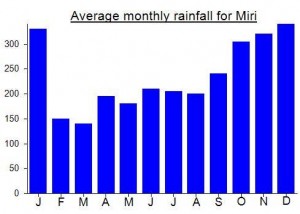
Local Average Monthly Rainfall (mm):
Hi Daniel, it was blessing to meet you during our trek & it gave us an eye opening experiences of yours passion to summit almost every weekend. Jumpa Lagi – from Ghia
Well, Murud is definitely my favourite hike of 2018 so far. After all the problems I encountered during my previous Sarawak trip it was wonderful to have things go very smoothly second time around.
To get there from Jakarta, the simplest way is probably to take a direct flight to Kota Kinabalu and then arrange land transportation to Lawas and take the MASwings flight from Lawas to Ba’kelalan. However, as I wanted to go to Kuching first, I actually ended up flying Jakarta to Pontianak to Kuching to Miri to Bario to Ba’kelalan and then back out via Lawas, Miri, Kuching and Pontianak! This is not necessary unless you too are wanting to explore the Kuching area. Flying in via Bario (just one flight a week connecting Bario with Ba’kelalan) is fabulous as you get amazing views of Mulu and Batu Lawi.
It was great to meet a group of 3 Malaysian hikers (Nigel, Ashok, Joyce) on the plane who were also going to hike Murud at the same time. It was fortunate that our dates were almost identical as it meant they could share 4WD transport with me (paying for this alone would have been a massive expense and I probably would have walked back down on the way out) and I could share Gukang, the local guide who I had booked months previously, with them (there are very few other local guides for Murud at present). It worked out very nicely. I also met the very friendly Luke Southwell, the adopted son of Hudson Southwell, one of the missionaries who brought Christianity to the region, plus Rob, an Australian anthropologist staying in the area doing research on rice production.
Ba’kelalan is a lovely little place. The runway is just 549m long – allegedly the shortest in Malaysia. It is fun, and slightly terrifying coming in to land as there are hills surrounding the valley!
Gukang was waiting there, in an Australian (?) hat. I immediately liked him – he is one of the best guides I have hiked with and is an expert on Murud. The local tribe are the Lun Bawang (nothing to do with onions apparently!) and they have lots of links with the villages and people over in North Kalimantan, just a few kilometres away.
Everyone goes on about the quality of the Bario rice, but apparently much of the Bario rice actually comes fro the Ba’kelalan area and over the border in Kalimantan! The salt in this region is of great quality too, full of iodine, and allegedly responsible for the high level of intelligence of the local people (the Kelabits in Bario were named one of the 7 most intelligent enthic groups in a major study, but I do not know quite how this was measured). The locals speak great English too, so my use of Bahasa Indonesia with Gukang was almost pointless, as he studied in English at school.
The highland region is proudly Christian for the most part, but if you are hoping, as I was, that beer is readily available then you will be in for a surprise as the drink is frowned upon by many and difficult to find outside of just one or two shops. Apparently after the locals stopped drinking, the rice production doubled!
The 3-day hike is wonderful, with the middle day being the longest one. It’s great not to have to worry about taking a tent with you, and given that you start up at 1,715m if you take a 4WD to Lepo Bunga it is effectively a long ridge-walk for the most part. Day 2 is also the day that you really hope you get good weather for the trke to the summit and for photos at the stunning Rock Garden.
On the third day, I went on ahead back up to Batu Linanit, and sat there for an hour alone, watching the early morning mists swirl around distant valleys in both Malaysia and Indonesia. It was a genuinely transcendental experience.
The name Murud might possibly derive from Murut, the name of an ethnic group literally meaning ‘hill people’: https://en.wikipedia.org/wiki/Murut_people
Contact details (in 2018):
Guide – Gukang +60128056372 or via Gukang’s daughter or son +601114013212
Transport to/from Lepo Bunga RM350, RM100 porter, RM150 guide
Accommodation – several places in Ba’kelalan, some not so easy to contact in advance but there is almost always space available upon arrival. Apple Lodge : applelodge@borneojunglesafari.com or search for the excellent Owl House homestay if you have a bit more to spend or are especially interested in birdwatching.
If you dont’ mind, I would like to share some information on how to get to Mount Murud as well.
http://wilsonchin.blogspot.my/2016/07/mount-murud-exploration-journey-to.html
Thank you.
Unfortunately my planned hike of Murud fell apart before it began. Hopefully my trip report will point others trying to do similar how they might increase their chances of success.
The previous night I stayed at a guesthouse opposite Miri airport so I would have a short walk over to board the plane the following morning. I was a little worried about the weight of my luggage and had been doing what I could to dry it out as much of my clothes as possible to reduce the weight. After standing on the scales at Miri airport I was told the weight was fine.
Having previously researched Murud and found a fiar bit of information online I was confident I could complete the trek in 4 days, with one day either side to fly in and out of the Kelabit Highlands. The only treks that it seemed possible to book in advance were immensely expensive and for large groups. The Lonely Planet mentions one which is 1500 Ringgit per person with a minimum group of 4. So that’s 6000 Ringgit, about 1140 Pounds Sterling, just to get started. Naturally I expected to be able to arrange a far more reasonable price in the local area after talking with local guides and explaining that I was not with a large group but on my own. Over the border in Indonesia (just a few kilometres from the Kelabit Highlands) you can almost always arrange a fairly priced hiking trip there and then, last minute, instead of paying over the odds in advance. My mistake was thinking it would be as easy to arrange such a trip in Malaysia.
The flight itself makes a trip to the Kelabit Highlands worthwhile. On a lovely 18-seater twin otter ‘Pratt and Whitney Dependable Engines’ written on the side you will get some amazing views over some of the most remote areas of Sarawak. You need to be sitting on the left side for the best views but, given that lots of goods are transported this way and their weight is in lieu of some passengers, you may well find that there are a few spare seats on either side of the little plane.
The first thing to look out for is the Mulu range – seen from a very different angle and of great interest, especially to those who have perhaps just been trekking in Mulu Park. It is an immense area, and the summit peak looks even more remote from above, surrounded by endless forest, than it feels standing on top of it.
After you have passed Mulu, next up is Batu Lawi (2,040m) – sometimes spelt Batu Lawih locally – a fantastic twin rock pinnacle on top of a mountain. The lower ‘female’ peak can be climbed as part of a 4 or 5-day trek from Bario but the taller ‘male’ peak requires expert rock climbing skills and ropes. Just to the rear of Batu Lawi is Gunung Murud itself.
There is no door between the passengers and the pilot so you will see the whole approach and landing. Bario airport is a nice, peaceful little spot, feeling very much in the middle of nowhere. The temperature up here at over 1000 metres is very pleasant. The local Bario rice and pineapples are much sought after.
There were a couple of other tourists leaving as I was arriving but other than them I didn’t meet any others. There are several places to stay in and around Bario so I decided to walk into town and have a chat with whoever was around and find a place to stay based on what I could find out from local guides.
The town itself – village really – was exceedingly quiet – all the shops were shuttered and there were very few people around. Later I found out that they were all working in the fields at this important time of year, but it was quite a surprise as I have read reports of guides actively approaching tourists to propose treks in the area.
The first sign I saw for a homestay was the Nancy Harriss, so I strolled to the house and had a chat with the friendly Irene, a former Mulu guide. I told her my intention to climb Murud and she said she knew just the chap to be my guide, an experience local guy. Things were looking up so I checked in for the night and waited for this guide to appear. The cost was 70 Ringgit for the room including all meals. Nobody else was staying there.
The homestay is owned by one of Tom Harrisson’s local relatives. Tom is famous in the local area – he and his men parachuted into theis area during March 1945 as part of a military exercise by British and Merican troops to encourage locals to stand up and fight against the Japanese. There is a monument to Tom on the outskirts of Bario and he went on to become one of the best sources of knowledge of wild areas of Sarawak during the 20th century.
At the homestay itself was a very encouraging map of the local area, with trekking routes between villages and up Murud clearly marked. The guide didn’t appear during the first couple of hours so I took a walk back into the village to see if I could buy supplies ready for the hike and have a chat with locals so I had a plan B guide ready. Unfortunately, the only shop I could buy anything from (I.e the only shop that appeared open) had little except bottled water and very basic snacks and it was being looked after by young children! I would have to wait until later.
I continued along the road to eBario where I hoped to check my email. This, too, was closed. As luck would have it, the guide Irene had mentioned actually found me in the street. Unfortunately he didn’t seem confident about getting to the summit, especially not in four days, couldn’t tell me how many times or if he had climbed it before, and couldn’t propose a price for himself and a porter to form a team. Neither could he arrange transport to Pa Lungan the following morning, something which would be more or less essential to completing the traverse to Bakelalan in four days. His own price would be 120 Ringgit per day. Not cheap, but certainly cheaper than the 200 Ringgit per day that guides allegedly charge over in Bakalalan.
Unconvinced, I asked him to come to the homestay after he had found a porter and got a full price for the trek and found out about the possibility of transport to the trailhead. Back at the homestay we would be able to finalise our plans with the additional use of the map on the wall.
He never returned and Irene was also out all day, so I basically stood around or paced about waiting for news, unable to find anyone else in town with any information, and keen not to upset anyone by simply heading off for Pa Lungan myself the same day. In hindsight, I should have tried to get to Pa Lungan the same day I arrived instead of staying in Bario.
In the meantime I read about Bruno Manser, Swiss rainforest and human rights activist who lived with the indigenous Penan tribe for several years. He went missing in May 2000 on his way to climb Batu Lawi near Bario. Many people assume that he was abducted and murdered as ‘revenge’ for his encouragement of blockades to prevent further logging in the area and his publicisation of the environmental devastation that the Sarawak state government’s support of widespread logging and palm oil plantations was having.
The Penan tribe were particularly badly affected, being evicted from their traditional areas with little or no compensation. The problems continue to this day as the logging areas grow and grow throughout Sarawak. Anyone flying over Sarawak need only look out of the window on a clear day to see the devastation, with logging roads criss-crossing huge areas of land and immense grid-like formations of palm oil plantation. Reading about Bruno Manser probably didn’t help my feelings about where I was staying.
By nightfall, the electricity finally came on and Irene returned. I asked about the guide and said we had not fixed a plan or been able to buy any supplies for an early start in the morning. Things just weren’t panning out and, having been standing around alone waiting for news or trying to get some information and getting nowhere, the day had been a very frustrating one. Even if the guide had returned I felt unconfident about him leading a multi-day trek from a safety point of view as much as anything.
Additionally, I was due to fly out from Bakelalan 5 days later but given the lack of information and the cost of just one guide, let alone a guide and a porter, and the unlikelihood that it would be possible now that our preparation time was almost over, I decided to, instead of pay 480 Ringgit for the guide to just take me to Bakelalan forgetting Murud summit (and then for him to return to Bario) it would be better to simply return to Miri by plane the following morning for the standard 117 ringgit. My feelings had changed considerably and I wanted to get out of there.
The following morning I gulped down my coffee and walked back to the airport just after first light, keen to see if there was a seat on the first plane back to Miri. I was in luck, disappointed to have failed on the mission but quite honestly pleased I was leaving Bario. It’s interesting how seemingly small decisions can alter the course of your project in significant ways. I daresay if I had found myself at a different homestay on the other side of Bario things may well have turned out very differently and the trek would have gone ahead. Who can tell?
To conclude, if you want to hike Murud, allow a week if you fancy trying to arrange things yourself in the local area. Even if you can find a decent guide, he might not be available until the following day, or even the day after that. If you are part of a large group and have plenty of money to spend then you might aswell book a tour in advance with an online agent.
Here’s an account of an ascent to the summit
http://outdoorsmalaysia.blogspot.com/2010/10/gunung-murudmountain-for-soul-part-1.html