
Facts
- Elevation: 1,929 m (6,329 ft)
- Prominence: 938 m
- Peak category:
 Spesial
 - Province:
 Banten
 - Coordinates: -6.7108, 106.4517
- Rating:

 (4 votes) Add your rating
 Loading...
Photos


Bagging It!
Mount Halimun is surrounded by the largest area of unspoilt rainforest in Java and the summit of the range (Halimun Utara – ‘Halimun North’) unsurprisingly lies within Gunung Halimun-Salak National Park. The peak is right on the border of West Java and Banten and it is debatable exactly which side the summit lies. There are lots of waterfalls in the area, and the bumpy tracks around the foothills are popular with trail-bikers at weekends.
The mountain range is incredibly extensive, stretching up from not far north of the south coast of Java near Pelabuhan Ratu all the way north to Gunung Endut (1,296m) which is a significant peak a few kilometres south-west of Cipanas (a different Cipanas to the many others such as the one near Garut but where there is unsurprisingly natural hot water bathing pools), and Gunung Gede (1,012m), a outlying peak about 10 kilometres south of Jasinga on the main Bogor-Rangkasbitung road running east-west.
Since combining forces with the Gunung Salak National Park, the Halimun-Salak area covers around 400 square kilometres, including an 11-km forest corridor stretching between the two peaks of Halimun and Salak. The Halimun area in particular is home to populations of Javan leopards, Javan lutungs and silvery gibbons.
Perhaps not sururpsingly, there are strict rules about access to parts of this huge conservation area. Whereas there are popular hiking routes on Gunung Salak, Gunung Halimun is harder to access unless you are conducting approved scientific research. Halimun remains quite mysterious, and lives up to its name of ‘misty mountain’, with very few (if any) having reported successful ascents to the highest point of the range. However, there are certainly a few minor treks that are possible on the edges of the park area and there are several good ‘days out’ exploring the region even if you don’t bag any peaks. Meeting one or two leeches is to be expected.
From south to north, the main peaks of the range over 1,500m high are as follows:
Gunung Talaga / Telaga – 1,631m. One of the most accessible tops in the Halimun area. The trail starts at around 730m in Pangguyangan, Sirnarasa (within fairly easy reach of Pelabuhan Ratu on the south coast of Java) and it takes under 3 hours to the lesser southern top (approximately 1,600m). A second top 15 minutes further is higher but was overgrown (in 2011). The name Talaga (‘lake’) apparently refers to a small lake at the foot of the mountain.
Gunung Halimun Selatan (South) – 1,758m. A remote peak and one of two that give their name to the range as a whole. Probably best attempted via Gunung Talaga but likely to be very overgrown.
Gunung Kendeng – 1,680m north top (and 1,761m south top). Accessed from Cikaniki Research Station. Supposedly good views and pitcher plants near the north top. Trail quality unknown at present and although this was once open to ordinary folk it is now sadly closed to all except researchers.
Gunung Botol – 1,797m. This eastern top is accessed easily from Pasir Banteng near Nirmala tea plantations in just one hour. Local guides suggest that there is a ‘Gunung Botol 2’ nearby but it is unclear if this is higher or lower than Botol 1.
Gunung Halimun Utara (North) – 1,929m. The obscure highest peak in the Halimun range with unclear access. This is not marked on the Bakosurtanal map but can be found by looking for the name ‘G Bintonggading’ and then moving to the province boundary line. The highest peak is assumed to be the one a couple of hundred metres south-west of the 1,911m elevation spot height. Note that Gunung Sanggabuana (approximately 2 kilometres south-southwest) is perhaps the second highest in the entire range at 1,920m.
Assuming you have permission to hike to Halimun Utara from Park staff, it would appear that a hike to the true summit of Halimun Utara would be best started at one of the following two places:
- At the north of the mountain in the village of Leuwijamang / Lewijamang (at 800m elevation) which lies an hour’s walk from the nearest road at Cisarua. To get there, you have to take the main road which heads west from Bogor towards Rangkasbitung and turn left (south) at Cigudeg or Nanggung. We haven’t been to Leuwijamang, so please leave a comment below if you can add any important information. One source states a return journey from here to the peak takes a minimum of 8 hours. This is probably a gross underestimate unless a group has been up there just prior to your visit.
- At the Nirmala tea plantation at Malasari (‘kebun teh Nirmala’) to the east of the peak. There is a bumpy plantation track up as far as around 1,560m above sea level at Pasir Banteng. Use the Nanggung junction on the Bogor-Rangkasbitung road.
Reaching the Nirmala / Malasari area from Jakarta takes around 4 hours in good traffic conditions, mainly because the track into the tea plantation is very bumpy (especially the second half of the 28km from Curugbitung (CRB on road-side signs) to Nirmala) and should really only be negotiated with a trailbike or a 4WD. Vehicles such as these can make it as far as Pasir Banteng (1,557m), but you could also leave your vehicle at a wide junction (suitable for turning) next to a sign (1,355m) 2km below the huge greenhouses and village at Nirmala and enjoy the 30 minute walk through the tea plantations. Views from here towards Gunung Salak and Gede-Pangrango are supposed to be excellent in clear weather at first light, though it is often misty here.
It is a surreal location – vast tea plantations with seemingly very few people for many kilometres and then suddenly a large village appearing out of the blue. Between Nirmala greenhouses (where there is a warung) and Pasir Banteng (the end of the track leading up into the hills) is a large training centre owned by the Sinarmas group. There is even a usually-deserted restaurant here, but be warned that the prices are extortionate for the few hikers or tourists who pass by this way.
Finding a local guide here in the morning is not always easy as most are working as tea pickers and will not be free (except, for example, from lunchtime on a Saturday). Even with a local guide, there is seemingly very little local knowledge about Halimun Utara, and although it is only 4 or 5 kilometres away (and less than 400 metres higher) it seems that the only peak that is well-known at Pasir Banteng is Gunung Botol (1,797m). After entering scrub and then forest (at 1,596m), Gunung Botol takes just one hour to reach and offers no views at all. From Gunung Botol, a couple of faint trails continue in two directions, but neither of them seem to head in the direction of Halimun Utara. Therefore you would either need to ask Park staff (and obtain permission which is very difficult indeed) or try asking at the alternative starting point of Leuwijamang.
A little further south of the Malasari / Nirmala tea plantations is Citalahab (1,100m), a group of small villages. Birdwatchers often stay with local families in this area. 4 kilometres south again is the Cikaniki Research Station (1,050m). It is possible to stay here, but you need to book well in advance because there are often students and researchers using the accommodation. You will also have to pay the expensive entrance fee if you are not an Indonesian citizen.
Next to Cikaniki is Gunung Kendeng (see above). It used to be possible to hike to the top of this peak and see some pitcher plants on the summit ridge and enjoy the views to distant mountains. In 2018, access to ordinary hikers (as opposed to scientific researchers) is no longer permitted. Cikaniki can still be reached from the road running south of Bogor near Parungkuda via Kapala Nunggal, Kabandungan and Cipeuteuy. It takes anything from 2 to 4 hours to cover the 50km and is best attempted in a 4WD.
The western side of the vast Halimun range is famous for being home to the genuinely unique Baduy (or ‘Badui’) tribes, who generally practice the Sunda Wiwitan animist belief system, shun foreign influences including vehicles, footwear, electronic devices and modern clothing. You sometimes see them on the outskirts of Jakarta, often selling bottles of honey, having walked all the way from their villages in the foothills of Gunung Halimun near Rangkasbitung.
The outer Baduy villages (Baduy Luar) can be visited via Ciboleger about 20 kilometres due south of Rangkasbitung or 20 kilometres south-west of Jasinga. The Inner Baduy (Baduy Dalam) remain off limits to all foreigners and to this day they have only limited contact with a small number of other Indonesians.
The most interesting area for hikers and mountain photographers in this western side of the range is the picturesque enclave Citorek, a traditional upland valley surrounded by the Halimun forests. Getting there is time consuming and reliant on there having been no major landslides or new construction projects underway at the time. You need to get a recent update on the state of the road as the main route in from the north is at the time of writing (March 2020) not usable by cars and we have no recent reliable information on the southern route from the Pelabuhan Ratu area.
In late 2019, the hills near Ciusul about 15 minutes by car or motorbike south of Citorek were popularised as ‘Negeri di Atas Awan’) on Instagram as a great place to see the sunrise and witness the view from ‘the land above the clouds’. There are several spots in Indonesia using a very similar name, but this one is especially popular owing to its relatively close location to Jakarta. The newly-famous viewpoint is just 2 minutes’ walk from the road on Gunung Luhur (the Bakosurtanal map gives the names Gunung Saga – 1,049m and Gunung Luhur – 1,037m – to the north and south tops respectively) with various wooden constructions for posing on or next to. The viewpoint is not actually as either of the peaks on the Bakosurtanal maps, but the northern slopes including one or two spots lower down where you can pull over and avoid the crowds.
It is indeed a great place to see the dawn clouds down in the Citorek valley, with the sun rising behind the highest peaks of the Halimun range many kilometres to the east. But the huge popularity of the place on social media actually means it is advisable to avoid the area on weekends as in September 2019 several thousand visitors arriving, and according to media reports this created a tailback (macet) for 7 kilometres through one of the least populated parts of Java! The site was closed shortly afterwards, to allow for the road to be properly paved and perhaps to allow for some proper thinking about how to best manage it. In Java, both the positive and negative powers of online popularity are highly visible.
In 2020 it appears to be much less popular, ‘thanks’ to a landslide washing a bridge away in Lebak Gedong making access for cars from the north impossible. Even those attempting it with motorbikes will need 4-6 hours from Jakarta (one-way including rests), and a lot of patience! It is a remarkable day out though, passing through about as wide a variety of scenes in one day as is possible.
In Citorek itself, there are lots of traditional wooden buildings, very similar if not exactly the same as the Baduy villages examples further west. With the forested hills, traditional wooden buildings and rice terraces, it is a truly picturesque place. A 2-3 hour trek towards the west will take you to an ancient stone wall terrace ‘pyramid’ of unknown antiquity called Situs Lebak Cibedug (or ‘Cibedug Temple’) and some other ancient megaliths such as upright stones at Situs Punden Berundak Lebak Cibedug. In 2020, these can be accessed on a motorbike, but 1 hour is needed to get there from Citorek.
Other interesting megalithic and ancient sites scattered across the Halimun range include the impressive Situs Tugu Gede monolith (over 3 metres high) way down south in Cengkuk about 30 minutes by car or motorbike from Pelabuhan Ratu on the south coast.
Various north-south or south-north journeys following a variety of roads and rough tracks through the entire range by mountain bike is possible over a couple of days, but this obviously does not include any actual trekking on foot or visits to any mountain peaks.
Information by Dan Quinn, May 2020.
Trail Map
For a high quality PDF version of this and other trail maps, please download from our Trail Maps page.
Practicalities
- Getting there: For domestic flights from or to Banten, such as Jakarta’s Soekarno-Hatta International Airport, we recommend Baolau. For Nirmala/Malasari: Take a train or bus to Bogor and then public transport /taxi to Nanggung (on the road west towards Rangkasbitung). Angkots run part of the way up the hill but stop a long way prior to the National Park entrance arch. Ojeks probably required if you don’t have your own vehicle. For Citorek, there are two options: from the south near Pelabuhan Ratu via Warung Banten, or from the north via Jasinga, Cipanas, Lebak Gedong and Majasari but note than in early 2020 the vehicle bridge at Lebak Gedong has been destroyed by landslides and only motorbikes can get across using two simple temporary wooden village bridges, with assistance from villagers.
- Guides and GPS Tracks: Want a PDF version for your phone? Looking for a guide? Need GPS tracks and waypoints? Gunung Halimun information pack can be downloaded here.
- Trip planning assistance: Would you like Gunung Bagging to personally help you in arranging your whole trip? Please contact us here.
- Permits: You need a permit to enter the Park. Take a photocopy of your passport photo page. As noted above, it is currently not usually possible to get a permit to climb to the summit at the moment unless you are doing research! No permit is needed to visit Citorek as it is an enclave and accessed using public roads.
- Water sources: Take sufficient supplies with you and be sure to fill up your car or motorbike with fuel at every opportunity. There is a warung at Nirmala tea plantations and even a restaurant at the Sinarmas training centre but they are expensive and not to be relied upon!
- Accommodation: Try the Booking.com map above or use this link to search for suitable hotels, homestays, resorts and apartments for your trip.
- We recommend Safety Wing as travel insurance for overseas travellers and tourists hiking up to elevations not exceeding 4500 metres.
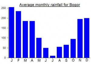
Local Average Monthly Rainfall (mm):
Location
Click on the blue arrow ![]() (top right) to see your current location on the map
(top right) to see your current location on the map
Origins and Meaning
Gunung Halimun means ‘mountain of mist’ in Sundanese.
Had another trip to the Halimun area this past weekend. After all the social media stuff about Negeri di Atas Awan (of which there are several with similar names (eg ‘Negeri Atas Angin’ near Bojonegoro) scattered around Java and probably elsewhere) I thought it was a good excuse to head into the western side of the range from the Jasinga area, heading all the way to the Citorek valley which is perhaps the most substantial large village or small town in the whole Halimun range.
We set off from BSD at midnight. If you live in Jakarta, you could try heading to Bogor and then west to Jasinga, or even heading west to Balaraja on the Merak toll road before heading southwards. But for us, the fastest route was via Padang Panjang. At night, this whole area feels like a never-ending quarry or building site, endless trucks clogging the road, throwing up dust, and men at the sides of the roads, primitively smashing large rocks with tiny hammers. In the middle of the night!
Further down you end up in palm oil plantation, and then those of us on motorbikes can take an unsignposted right turn cutting straight down to Jasinga. At night, this quiet, narrow road, complete with a cemetery or two, scared the hell out of my co-riders and they were delighted when we reached the main road at Jasinga and found a warung for a drink.
From Jasinga, the road up into the hills is quiet, but wide (newly-surfaced?) so pretty enjoyable but windy riding. Do be sure to fill up with fuel though, because options up in the villages are few and far between, especially in the middle of the night! There are Indomarets are every major village, but they are not 24 hour! In the Cipanas area there are lots of Islamic boarding schools for some reason, on the edge of the Halimun range.
Although we had set out early, we were quite surprised to see very little traffic heading up the same way as us, especially as it is the only real route in from the north, and on a Saturday night / Sunday morning you would expect it to be at its peak of business for Negeri Di Atas Awan. At one point the road is very steep and very damaged, to the extent that a group of villagers was on hand 24 hours a day to help push bikes up it (and hold their hands and boxes out for money, as is the tradition).
At Lebak Gedong we found the reason why there were so few others travelling in the same direction. We were also chased by some feral dogs! A group of youths stood around on the road – remember this was around 2:30am! And it is a good job they were standing in the road as there didn’t appear to be any signs to prepare night travelers what was coming next. A river – with no way across – road and bridge completely washed away in a landslide or flood in January 2020.
It was a little intimidating having this group huddle around us, doing the usual of looking for money in order to help us across to the other side, holding cardboard boxes to collect our cash, and asking for a photo with Mister! As it was unclear quite how you would get over to the other side as the road bridge was certainly washed out, we retreated to the Indomaret (closed at night) and sat down and contemplated heading home! Already a hell of a lot of work to get here and now unclear how we would continue our journey (and do the same thing in the reverse direction later on).
But after a group of trailbikers zoomed past and didn’t turn back, we decided to pay the villagers Rp30,000 to show us up the muddy slopes and onto what we discovered were two simple wooden bridges, wide enough to take bikes across. Not sure of the weight limit, but you can barely see anything in the pitch black anyway! So we just went for it.
Once over on the other side, one of our bikes started having difficulty accelerating up the road. Turned out he hadn’t filled up with fuel, so we had to share the fuel from our own tank between 2! Always remember enough fuel, especially at night! After sorting that out, we found another closed Indomaret to have a quick rest. One of our group asked why we had come this way – that there must be an easier route. Well, unless you live in Pelabuhan Ratu there simply isn’t! It is quite an ordeal, halfway between trauma and adventure! We also had a pet accompanying us – a month-old otter! It was like a bizarre dream, especially not having slept much the night before!
Finally we made it to Citorek where there are several pom bensin minis – little fuel stations at the front of peoples’ stores. We filled both bikes up to the maximum and continued as the sky began to lighten for the final 15 or 20 minutes up to the Gunung Luhur viewpoint. We were just about perfectly in time for sunrise – my original plan of leaving at 2am might have meant we would have only been up here by 7am at the earliest. Google’s 3 hours from BSD is complete nonsense, especially as it appears not to even register that the bridge is out of action at Lebak Gedong. With breaks, we needed 6 hours but 4 hours and 30 minutes is probably doable in ideal conditions and with bridges that are in place rather than washed away.
The name ‘negeri di atas awan’ did not disappoint, as we did have cloud down in the Citorek valley as we rode up the steep, newly-built road curving up Gunung Luhur. The viewpoints below the carpark and main spot are actually just as good, especially if you want a bit of solitude. Up at the carpark, it’s Rp5,000 to park, Rp5,000 to visit the viewpoint and so on. There are even bamboo houses you can stay in for the night. There were about 30 others up there – so the lack of bridge was a real blessing as who really enjoys sitting on a bike for 6 hours to be surrounded by noisy people shouting ‘hello mister’ at you?! It didn’t help that my trousers had completely split, so I must have appeared like some alien Mr Bean character, trying to wrap a jacket round my waist to hide my pale upper thighs from other visitors!
Back down in Citorek, we called off for food at a small but friendly café at the right-angle turn in the main road – Warung Simpang? The woman told me it takes about 1 hour to get to Situs Lebak Cibedug. Only 4 or 5 kilometres but… still an hour away. As we were all absolutely knackered after the journey I suggested we could miss it out, as it would be an additional 2 hours and we still have to get back across the wooden bridges, something you want to have done before the afternoon rains! Halimun does indeed seem to be one of the best places in Java for ancient stone monuments, large and small. I did some online reading and it turns out there’s another interesting ancient pyramid thing about 1 hour east of Bandar Lampung in southern Sumatra too – another one to visit….someday.
Back down at the bridges it all became a bit clearer in the daylight. We paid a local guy Rp20,000 to take one of our bikes over as it is quite tough dragging it up and down muddy tracks. Very interesting to note that this kind of ‘infrastructure disaster’ actually helps locals (at least those who haven’t had their property damaged in the event) by giving them a job they can charge for every time someone wants to come past! You wonder how it might be possible to incentivise decent infrastructure when locals cannot see any immediate financial benefit from it (but quite the opposite when there is a problem that they can fix for you for a small fee). If you’re a tax payer, you would hope the government would be responsible for important public infrastructure repairs, so it’s a little unfair to pay your tax and then as is so often the case in rural Indonesia, get asked for money towards local, simple infrastructure projects. Until most Indonesians pay tax it is hard to see this tradition dying out.
We stopped at another warung a few kilometres before Jasinga in the palm oil plantations, dazed and confused. The otter needed a rest too, most probably. The short-cut road on the other side of Jasinga seemed a lot less spooky than at night, and the road up to Padang Panjang was not quite as horrific or truck-filled as at night, but still a fair number and lots of dust in the air making a face-mask pretty useful. Padang Panjang itself leaves a lot to be desired, despite being on the commuter line train network. Finlly made it back home to BSD by around 1pm – so about 4 and a bit hours for the return journey. It’s easier in daylight. Then we had to return the motorbikes to South Jakarta before finally getting some sleep.
Quite an exhausting experience, but some great photos and some good memories of all these different places.
Just had confirmation that even Gn Kendeng is now closed to ordinary folk. Basically all the peaks are officially closed in Halimun-Salak except Gunung Salak. A shame, as I was hoping to visit Cikaniki from the Parungkuda side (east) and spend a night there before hiking up Kendeng.
Interesting to note the inclusion of Gn Kendeng as a tourism destination on an old map of the area at the training centre at Nirmala/ Malasari. Access is getting more and more difficult. For further details try Pak Yossi 0812 8192452.
Had another little explore of the Halimun area last weekend – this time from the north. Strange that I hadn’t been up here before, but the bad roads, lack of information and access issues meant I left it for years before investigating. Even after this trip it remains a mysterious range. You rarely get a glimpse of the true highest peak from anywhere. Weirdly, a south-west facing tower block in South Jakarta or Bintaro or BSD may be your best bet first thing in the morning in unusually clear conditions.
Indeed, it is close as the crow flies from Jakarta, but is a real effort getting down here, except in the middle of the night – at which time navigating the tea plantation tracks would be dangerous and difficult. We cut through a load of estates from Bintaro down to Ciampea and the Batu Roti – bread rock mountain on the usually congested Bogor-Rangkasbitung road. There was a huge storm so we stopped off for food and supplies at Nanggung, the junction for the road up into the hills.
Blue angkots do run up the hill for several km from Nanggung, but they are typically so frustratingly inefficient that ojeks or walking would probably be better unless you have a particular liking for these hideous vehicles. The roads are narrow (really only suitable for mono-directional traffic but the norm in Indonesia) but the surface is ok to begin with. There is one junction we reached where Google said go left so we went left to save ten minutes or less. This was a big error as we ended up on a steep and stony track a long way before we should have ended up having to use steep and stony tracks. Anyway, we suddenly reached a village after feeling that we were in the middle of nowhere (it was already dark by this time) and better road surfacing.
We were soon at the junction with the original road where the boundary of the National Park is, with entrance arch and a sign for Malasari wisata (tourism stuff at the tea plantation). A few kilometres beyond this we stopped off to ask at a warung and ended up staying the night with villagers at this tiny hamlet just a couple of km into the Park area. At an elevation of around 1,070m. Didn’t catch the name of the village and the accommodation was basic, but a very friendly family indeed. Two young women lived there with their friendly parents, after having been married at 14 (‘it’s normal in the village, mister’) and then divorced again (‘due to economy reasons’).
We were up at 5am and continued on the track which deteriorated permanently soon afterwards. Lots of police training goes on in this area, so don’t be alarmed when you see signs with ‘jungle warfare’ on them! Alas, the morning was overcast so there was no great sunrise but still it was lovely to be in the middle of a tea plantation all of a sudden. We left the car at the 2km Nirmala sign junction and walked up to the surreal buildings and village at the very upper reaches of the tea estate. Even weirder to see a Sinarmas training centre up here. Lovely spot, but can’t see it being used very much given the state of the road in.
We managed to find a couple of local chaps at Pasir Banteng to take us on a wander. We made it up to Gunung Botol in no time, where the guides spotted a cobra! I didn’t see it as it must have slithered off rapidly once the guides starting poking around looking for it! Beyond this top, the terrain was very tough. A few tags on trees and ribbons mark a recent Kopassus training exercise in the forest here and presumably some scientific research of some kind or another. We gave up and headed back down.
Given that there is a restuarant at the training centre, we decided to have a quick bite to eat there. A huge lounge complete with billiard table, maps and so on. But dirty and appeared as if nobody had been to stay up here for a long time. But there were some locals eager to offer us food so we accepted. Should have checked the price or asked for a menu (didn’t seem to be one) beforehand as for nasi goreng, cassava and 2 teas they asked for a ridiculous Rp200,000. Amazing that even when locals know you have lived in Indonesia for a while, and know the price of things, that they can pluck these outlandish figures out of the air, as if you have just been nodding and accepting being ripped off for all the years you have spent here! Utterly bizarre. Anyway, the price was suddenly reduced to Rp100,000 when they saw our surprise – another price randomly plucked out of nowhere. A shame, as otherwise I would have considered coming back here. When it is a constant battle just to get people to be reasonable with you and not try to rape your wallet every half hour it becomes deeply unenjoyable. No moral compass whatsoever! ‘Ethics, morals, what are they, mister? I’ll take whatever I can!’
It took us over 4 hours to get back to Jakarta – mainly due to horrendous congestion near Leuwiliang and then on the toll road from Bogor. Chaos. But a decent trip out. Having seen a mention on one of the maps in the training centre of views from the top of Gn Kendeng near Cikaniki Research Station I am quite tempted to come out to Halimun again soon, especially if it can be accessed from the Bogor-Sukabumi side for a change (ideally, would get the train from Bogor Paledang to Parungkuda or Cibadak). I also spotted a photo or two online of a triangulation pillar supposedly on a peak somewhere here that I haven’t yet visited. I guess that it is at the top of Kendeng but am still seeking confirmation……
The people living there called the mountain “menir” (north halimun peak)
No, i’ve Summit meneer peak. It’s not halimun Kaler. I’ve reached bintong gading but the explorer need partner to open waytrack for reach north halimun ..
What a shame! Is there any updates on this issue?
Just back from a roasting hot Java Lava weekend down near Pelabuhan Ratu. First day was a lengthy coastal hike down to Sawarna via some beautiful, remote beaches, second day an ascent of Gunung Talaga on the southern edge of Halimun National Park. The well-defined trail starts at 730m in Pangguyangan and it takes about 2 and a half hours to the top with some extensive views on the way up – both down to the coast and inland over minor peaks and bumps within the National Park. The more commonly-visited first top is 1600m – a second top 15 minutes further is a higher peak (1630m) although it is much more overgrown. Not much in the way of views from either summit, but 5 minutes beyond the true peak there is a spot where in clear weather you should get some great views east towards Salak etc. According to Google Earth the very highest part of the mountain is even further beyond – perhaps another 30 minutes if the trail was clear – but the trail is very overgrown.
The name Talaga (‘lake’) apparently refers to a (presumably small) lake at the foot of the mountain.
For several weeks, I have been trying to arrange a hike to both Salak2 and Halimun Utara (North) which is the highest Halimun peak. Sadly, I have gotten nowhere. After finally managing to get in touch with a member of National Park staff, I explained that I wanted to climb to these peaks and that I would be willing to pay for a guide to help me do so. I was informed, politely, that because neither route is considered by Park authorities to be an official hiking route that it is actually ILLEGAL (!) to climb them. Very strange considering that Salak2 was commonly climbed in the past and should be considered a traditional hiking route (and therefore remain open). Salak2 is actually closed because the National Park does not have enough resources to keep it open – perhaps the Park should think about reducing the size of the Park boundaries then? Instead of embracing the opportunities of employing more people to take local and foreign tourists on a wider range of routes they decide to simply deny anyone the legal right to visit these areas.
The only way that you can officially explore these important places is if you are conducting official scientific research.
This is a real shame for all hikers in Indonesia, especially as Halimun and Salak are two of the nearest peaks to Jakarta.
I hope that some Indonesians will help to campaign for a change in the law which recognizes that hikers can be responsible for themselves and that National Parks are not supposed to prevent people from entering them. It is the same in East Java at Ijen-Merapi where climbing Merapi is technically illegal. This problem is likely to grow in size unless something is done to change the law and allow hikers greater access to these places which they deserve to have. Otherwise, bribery or paying a fine is the only way to enjoy visiting these mountain peaks. A ridiculous situation!