
Facts
- Elevation: 2,600 m (8,530 ft)
- Prominence: 938 m
- Peak category:
 Spesial
 - Province:
 Jawa Tengah (Central Java)
 - Coordinates: -7.1972, 109.9322
- Rating:

 (31 votes) Add your rating
 Loading...
 - Other names: ꦣꦶꦲꦾꦁ The highest mountain in Dieng is Gunung Prau, also spelt ‘Prahu’ and ‘Perahu’.
- Eruptions: Dieng 1375, 1786, 1826, 1847 (Pakuwaja), 1883-84 (Kawah Sikidang), 1928 (Kawah Timbang), 1939 (Kawah Timbang), 1943-44 (Kawah Sileri), 1945 (Kawah Candradimuka), 1953-54, 1956 (Kawah Sileri), 1964 (Kawah Sileri), 1979 (Kawah Sinila), 1981 (Kawah Sikidang), 1984 (Kawah Sileri), 1986 (Kawah Sileri), 1993, 2003 (Kawah Sibanteng and Sileri), 2009 (Kawah Sibanteng and Sileri), 2011, 2017 (Kawah Sileri), 2018 (Kawah Sileri)
Photos


Bagging It!
Introduction
The Dieng Plateau is a huge volcanic complex near the pleasant town of Wonosobo. It is quite rightly one of Central Java’s leading tourist attractions and there are so many fascinating sites, both geological and historical, that it definitely makes sense to stay in Dieng village itself and properly explore the place. Colourful lakes, hissing and bubbling craters (‘kawah’) and numerous temples (‘candi’) are dotted all over the landscape.
The area was a very important Hindu site and eight ancient Hindu temples remain here today, the main cluster being the Arjuna complex just a couple of hundred metres from Dieng village. These are supposedly the oldest temples in Java, dating from the Kalingga Kingdom era of the 7th and 8th centuries and it is thought that there were up to 400 temples here originally.
Nowadays, the Plateau is an important site for geothermal plants and, if anything, the steaming chimneys in several locations make the panoramas even more dazzling and unusual to behold.
The most impressive craters are the busy and popular Kawah Sikidang, the atmospheric and ghostly Kawah Sileri (which erupted phreatically without warning in July 2017) and the somewhat bizarre bubbling and smoking Kawah Candradimuka.
Because Dieng village is at an elevation of about 2,070m, the area is in general quite damp, chilly and often misty. Good visibility is most likely in the morning, hence the need to start your hike before first light for the most impressive views.
In July 2018, temperatures reached as low as minus 2 degrees Celsius, and most years the region has a few nights of thin ice or frost during the dry season. Locals call this ’embun upas’, literally ‘lethal dew’ as it can destroy crops. But tourists flock to the temples at these times to get photographs of what are rare scenes in Java.
As the climate here is subtropical, the crops grown successfully here include a fair number of vegetables that are found in Europe. The list includes delicious potatoes, onions and cabbages, and also a few more unusual things including carica which is also known as mountain papaya and resembles tropical papaya but with small fruit that have paler flesh.
There are numerous peaks and craters in the area, the most interesting of which are as follows (clockwise from Dieng village, key mountains to explore on a hike are named in bold, key other attractions worth visiting underlined, all elevation data taken from relevant Bakosurtanal maps unless better data is available):
- Gunung Prau (2,600m) – the tallest peak in the area, with the most fantastic views but also very crowded at weekends.
- Gunung Igir Binem – no peak as such but a crater home to two crater lakes, Telaga Warna and Telaga Pengilon.
- Gunung Pakuwaja (2,390m) – the second highest mountain in the Dieng area but rarely hiked at present despite offering great views.
- Gunung Sikunir (2,275m) and Seroja (2,252m) – Sikunir is another great viewpoint and incredibly easy, requiring a hike of just 20-30 minutes, but as is also the case with Gunung Prau it can be overcrowded if you visit on a weekend.
- Gunung Bisma (2,365m) – increasingly popular, the third highest in the region and – like Gunung Pakuwaja – a great viewpoint and makes a great traverse.
- Gunung Rogojembangan (2,177m) – a considerable distance to the west of Dieng village, Rogojembangan is perhaps best accessed separately from the north coast via Pekalongan.
- Kawah Sinila, Kawah Candradimuka and Telaga Dringo – fascinating but sometimes dangerous craters and volcanic features surrounded by the rarely hiked tops of Gunung Petarangan (2,152m), Gunung Alang (2,240m) and Gunung Jimat (2,210m).
- Gunung Sipandu (2,240m) above the craters of Kawah Pagerkandang and Kawah Sileri – the former crater is a completely agricultural crater that few tourists even know about and the latter a little way below is an atmospheric lake with mist hovering over the water.
- Gunung Pangonan (2,308m) – an easy 30-40 minute hike to the 500m-wide savanna from Dieng Kulon, and not far from Kawah Sikidang and the Arjuna temple complex.
Gunung Prau
The most popular easy ‘hike’ in the area is to the top of Gunung Sikunir (2,265m according to the Bako map) for sunrise but, despite the great views of other volcanoes in Central Java, this is a very easy stroll of less than 30 minutes each way and most keen hikers will be left wanting more.
The highest mountain in the Dieng area is called Gunung Prau, presumably because it slightly resembles a boat (see also Tangkuban Perahu near Bandung, West Java). It towers directly above Dieng village and can be climbed without the need for additional transport. Because Dieng village is already very high up, it is a relatively short and easy hike to the peak (2,600m). The views are absolutely spectacular at dawn – perhaps Central Java’s very finest. When I first wrote about it in 2010 it was quite possible to find the summit ridge deserted even at weekends, but now in 2019 you will probably be one of more than a thousand people up there enjoying the grand scenery on a Sunday morning.
There are actually multiple routes up Gunung Prau – in 2019 there are no less than 8 official ones, seemingly all with basecamps! The main 3 at present are Dieng village itself (recommended for ascent due to it being a short stroll from most hotels and homestays), Patakbanteng – which is only about 4km back along the Wonosobo road from Dieng (not recommended as this is already too popular at weekends with many hundreds of local hikers queuing up), and Wates, a less popular but very pleasant trail from the south-east (recommended for descent if you want to ‘traverse’ the mountain and have time to negotiate transport from what is a rather remote village).
Other trailheads include Kalilembu and Dwarawati (both very close to Dieng village and Patakbanteng therefore only of merit if the Patakbanteng trail is just too crowded), Kenjuran and Campurejo (both north of Wates and therefore worthy of investigation for those wishing to get back to the north coast afterwards but currently not clearly-marked so a guide is probably essential) and finally Pranten, which is west of the mountain and would therefore be better combined with a traverse to Wates, Kenjuran or Campurejo (again, a guide probably essential for this). Dwi, who works at Bu Djono homestay and restaurant, is especially recommended for any hikes in the area.
At present, the recommended hike for those not wishing to return the same way is from Dieng village up to the summit ridge and then down to Wates (or Kenjuran or Campurejo if you can find an experienced guide). Hikers who have Indonesian language skills and have hiked plenty of mountains in Java previously can manage the trail from Dieng village to Wates without a guide (assuming good weather and/or use of GPS tracks – see resources) though it is not a good idea to trek alone. On weekends you are not likely to be too far from other hikers on any of the three main trails. The Dieng village to summit to Wates route is described below. It is best to set off from Dieng village at 3am with a torch so that you reach the summit ridge by around 5am ready to watch the sunrise.
From Dieng village, behind the Dieng Homestay follow the cement track up past the school (right) and graves (left). After less than 10 minutes you will have reached the new Dieng basecamp (2,123m) where you can register (Rp10,000 in 2019) and take photos of Dieng village below from the large red letters spelling ‘GUNUNG PRAU’. You can also buy simple snacks and basic clothing items. The track is well sign-posted and leads up through farmland (mostly potato fields) and into pine forest (Pos 1, Gemekan, 2224m – reached after just 20 minutes from the basecamp) where it begins to ascend more steeply. After under one hour you will have reached a border marker (2,395m), marking the end of one region (Wonosobo) and the beginning of another (Batang). This is now known as Pos 2 – Semendung and is where the less-used trail up from Dwarawati meets the main Dieng village trail.
From Pos 2 you should be able to see the radio transmitter mast (2,559m, known as ‘repeater’ on the little map available at Dieng basecamp) as even at night there is a bright light on the tower itself. Whereas a few years ago the trail went up to the transmitter mast compound and more regional marker stones (2,560m), it now skirts round to the right of the ‘repeater’ peak meaning you don’t have to ascend to the tower and descend again along the ridge towards the true summit. You can simply do the short cut like everybody else does now – indeed, it seems that the trail to the repeater tower has been deliberately closed as the hike has grown so massively in popularity in the last few years.
After less than 90 minutes total from Dieng village you should have reached Pos 3 – Nganjir (2,518m) which is the start of the lovely ridge walk. It is quite narrow at this point with great views on either side. This ridge is presumably the remnants of an ancient crater wall and the trail is very easy to follow. After 20 minutes of hiking along the ridge you will reach the first important ‘peak’ which is marked with a cement marker with 2,565m written on it. In actual fact, this first peak is approximately 2,585m above sea level but the 2,565 figure seems to be the preferred one for t-shirts, stickers and so on that you can buy at the basecamps! From this top you will get your first proper view along the ridge to the south-east beyond a few other higher bumps and clumps of trees to the huge twins Sindoro (nearest) and Sumbing (taller but further away).
After this first peak, the trail drops down into a daisy-filled meadow area reminiscent of many small European hills. Some locals actually refer to this area as Bukit Teletubbies (Teletubbies hill) and Bukit Rindu (Longing hill). The meadow area is home to occasional and impressive trees, both lone and in clumps. From this point on you will start to notice more and more tents as you get closer to the junction with the route up from Patakbanteng.
The highest point on the ridge (2,600m – possibly known as Gunung Patakbanteng locally, listed as 2,590m on the Bakosurtanal map) lies about 2 km along the ridge from the radio masts and, given how easy the trail is, can be reached in 2 hours total from Dieng village. It is basically just a bump on the ridge on the right side of a bowl-like dip of the meadow and interestingly it is unmarked though you may find a tent or two on it on weekends! From the true summit you will have a fabulous view down to Dieng village, Telaga Warna, Kawah Sikidang, back along the ridge to the ‘repeater’ tower and, most beautifully, Sumbing, Sindoro, plus Merbabu and Merapi in the distance to the left of Sumbing and Sindoro.
20 minutes further along the ridge over a series of slightly less high bumps is the junction with the Patakbanteng trail. This is the most popular camping spot and it is not unusual to have hundreds of tents here at weekends (meaning thousands of hikers!) The vast majority will have hiked up from Patakbanteng. The Dieng village route sees far less but still perhaps 100 or so. The Wates route might see 50 or so. The other routes see very few. You can see why this spot is popular – brilliant views of Sumbing and Sindoro.
From this junction, you have several options. Returning the same way to Dieng village takes about 2 hours. You can also make a small circuit by descending to Patakbanteng village (turn right at the tents) from where it an easy 4km along the road back to Dieng village (ojeks should be readily available). Better still, if the weather is clear making route-finding easy, traverse the mountain by descending to the small and remote highland village of Wates (1,683m).
To descend to Wates from the Patakbanteng junction (i.e where all the tents usually are) continue south-east down the ridge on the clearest path you can see in the direction of Sindoro and Sumbing. After less than 20 minutes you should have reached a tree with a red and silver ‘Wates’ sign on it. Soon after this the trail drops down to the left of the highest part of the ridge. You should have reached Pos 3 (Sudung Dewo, 2,253m) in about 45 minutes from the Patakbanteng camping area. You are back in forest now so listen out for birdlife. It is then another 20 minutes to Pos 2 (Cemarang, 2,122m) and a further 20 minutes to Pos 1 (Blumbang Kodok, 1,973m) which has a pond and is the end of the forest. From here it is about 30 minutes down an often slippery farm path passing cabbage and potato fields. There are usually friendly farm workers around if you need help but the trail is pretty well signposted. The Wates basecamp (1,683m) can be reached in about 2 hours total from the summit ridge, meaning a total hike of under 5 hours from Dieng (not incuding breaks for photos etc.) Assuming you set out from Dieng village at 3am and spent around an hour taking photos on the ridge you will probably be down here no later than 9am. Treat yourself to some coffee and meatballs from the friendly Ibu at the basecamp!
The boys at basecamp have been doing a lot of work trying to promote this route to the top of Gunung Prau on social media. It is indeed a proper hiking trail – requiring slightly more effort than the Dieng and Patakbanteng easy routes up. To ascend from Wates to the summit ridge would probably take around 4 hours including rests, but you can get an ojek to Pos 1 for Rp20,000 (in 2017). They are also trying to publicise Bukit Larikan, a minor hill with a wooden or bamboo structure at the top, seemingly offering good views too.
Getting back round to Wonosobo from here shouldn’t be too difficult but you will need ojeks from villagers or the lads at basecamp. If you don’t have private transport already arranged and are trying to head to the north coast at Pekalongan or similar, you will probably have to pay around Rp75,000 per ojek for a 45-minute motorbike ride down to Candiroto terminal where there are regular small buses to Sukorejo (Rp10,000, 40 minutes). This ride down from Wates is very scenic – beautiful farming country (mostly tobacco and a bit of chili peppers). From Sukorejo terminal there are more small and uncomfortable buses on to Pekalongan via Bawang and Limpung (Rp40,000, 2 and a half hours).
Bagging information by Daniel Quinn (updated November 2020)
Gunung Igir Binem
Very few locals, let alone tourists, will have heard of this name but it’s the formal name for the large crater to the south of Dieng village that contains Telaga Warna (coloured lake) and Telaga Pengilon. The lakes are a pleasant place to take a stroll but foreign visitors should note the expensive entry fee of Rp100,000 (Rp150,000 on weekends and public holidays). If you just want a view of the lakes, it is recommended you head up to Batu Pandang Ratapan Angin viewpoint (Rp30,000 for foreigners or Rp10,000 for locals) near Dieng theatre instead where you can clamber up a few rocks to look over the lakes and to Dieng village and Gunung Prau.
Gunung Pakuwaja (2,390m)
Just to the south of Telaga Warna, the infrequently climbed mountain named Gunung Pakuwaja (also spelt Pakuwojo) is at 2,390m (as high as 2,399m according to GPS device) an important peak in the region and second only to the Prau ridge in height. Perhaps unsurprisingly it offers a great view early in the morning and you don’t have to share the hill with hundreds of others like is now the case on both Gunung Prau and Gunung Sikunir. There are very few trees so the view is open for most of the hike.
As with most of the peaks in the Dieng area, there are multiple routes up the hill from numerous different starting points. Without doubt, the best thing to do is a traverse from one side to the other. The most obvious traverse is from the road end beyond the Dieng Theatre and Batu Pandang near Telaga Warna, up to the summit and down to Sembungan. If doing it in that direction, allow about 2 hours to walk from Dieng village up to the peak and 1 hour down to Sembungan village where you should be able to find an ojek or other transport back to Dieng village.
At the end of the Batu Pandang road, continue on a muddy and occasionally boggy track as it skirts round to the left of Gunung Kendil (2,328m) which is essentially the northern peak of Pakuwaja but only the third highest. It is possible to hike up to the point from Desa Parikesit / Wadasputih to the north-east on the main road up from Wonosobo but it would take an extra half an hour as these villages are under 2,000m above sea level. There is a clear signpost for a Pakuwaja trailhead at the main road near Kings Hotel in Parikesit but it seems to not be popular compared to the trails up Prau on the other side of the road. You can also climb from further down at Tieng which is east of the mountain and under 1,900m.
After some geothermal pipes, drop down across potato fields and follow a farmers’ track up to the right to gain the ridge (2,260m) between Kendil and the higher slopes of Pakuwaja. Take a left here and as you finally get beyond the cultivated land and be prepared to get a little wet in the deep undergrowth.
A common site on Indonesian volcanoes, the vaccinium family Cantigi bush grows here and accordings to guides is a sign that volcanic activity is not dangerously high in the locality (otherwise it would have died). Sadly, the invasive Crocosmia / Montbretia plant also thrives here, which despite the nice orange flowers is a very difficult plant to get rid of in the UK, let alone the slightly warmer hill-tops of Dieng!
To the right, if you are lucky with the weather, you should be able to see the andesite pillar which allegedly gives Pakuwaja its name (‘paku’ means ‘nail’). This is best visited on your descent, so best stick to the ridge for now and continue to the grassy area which may have a simple sign informing you that you’re at the top of Dieng’s second highest hill.
There’s a slightly damaged summit pillar which is probably an old border marker of some sort, like the ones found on nearby Gunung Prau.
To the southwest of the summit is another top sufficiently separate enough to have its own name (Gunung Prambanan, 2,338m), and the ridge connecting the two is the favoured spot by local campers though it is quite likely you won’t meet any other groups. This ridge also alows some good views of the andesite pillar below and Gunung Bisma beyond.You may even see Gunung Slamet in the distance to the west and hopefully if the weather is good then Prau and Sindoro will both be clearly visible.
You will probably notice that the ridge with the pillar on divides what appears to be an old, marshy crater from another. It does indeed appear that there are at least two old craters here (smaller north-west and larger south-east) and on the way up you will probably have smelled sulphur from a side crater to the north, so like with much of this area there is still considerable activity beneath the surface here.
Retrace your steps and follow the ridge to the left with a cluster of Acacia trees growing on it. Veer left again to reach the base of the pillar itself (2,331m) which is probably around 25 metres tall. Head back to the junction and then southwest to the edge of the potato fields. From here it is easy to descend steeply to Sembungan village (2,117m) in about 30 minutes or just cut acorss to the nearby Sikunir Dieng Inn if you happen to be staying there.
Sembungan is allegedly the highest village in Java, and sits on the shores of yet another crater lake, Telaga Cebong.
An ojek back round to Dieng village (6km) should cost around Rp20,000 per person. If you do the hike in the opposite direction you may need to pay a little extra for ojeks if you want to start your hike at 4am or so. Best go with a guide if you are starting in the dark.
Gunung Sikunir (2,275m)
The popular, short hike up Gunung or Bukit Sikunir is best done for sunrise. The starting point, Sembungan, lies on the edge of a lake, Telaga Cebong, and at over 2,100m is said to be the highest village in all of Java. It takes about 20 minutes to reach by ojek from Dieng village (6 kilometres, around Rp30,000 per person during daylight). There are warungs and a carpark and at weekends the place will be full of mainly domestic tourists.
From there it’s just 20 minutes to the top of Gunung Sikunir on a very popular and well marked path, but it may take you longer if you get stuck behind a large group at weekends. You don’t really need a guide. The ‘golden sunrise’ is supposed to be particularly fine when viewed from Sikunir peak. 15 minutes or so after the golden sunrise on Sikunir, there is apparently a ‘silver sunrise’ at the Arjuna temple complex.
The stone trail up Sikunir has been ‘improved’ in recent years to catch up with the sheer volume of people on its slopes every weekend, to the extent that there are two prayer rooms on the mountain – one at 2,220m on a rare flat stretch of trail just below the summit area and one almost on the summit. The sunrise viewpoint (2,265m) has a small cement shelter and is where most hikers congregate, but it is worth having a look at the attractive rocks near the prayer room and the true summit (2,275m) which is much less popular and just 3 minutes to the north-east in what remains of forest on the top, overlooking Telaga Cebong and the car-park.
The peak of a very similar height just a few hundred metres to the south of Sikunir is the cultivated Gunung Seroja (2,252m) and is likely to be a good viewpoint as it overlooks the large lake to the south called Telaga Menjer which is a crater lake down at a much lower elevation of around 1,200m. It might be argued that Sikunir is actually simply the highest part of Seroja mountain which in total has three craters.
Gunung Bisma (2,365m)
A bit lower than Pakuwaja is the impressive-looking Gunung Bisma (2,359m on the Bako map, 2,365m according to other sources), also spelt Bismo, which lies a few kilometres west and forms the southern boundary of the plateau. It appears to be comprised of a huge crater wall that has been breached to the south-east in ancient times.
Gunung Bisma is a fabulous viewpoint and an excellent choice if you want to avoid the large crowds on Gunung Prau and can find a local person to take you to the top, though the trail on the Dieng side may be unclear unless it has been used recently.
There are at least three routes, but the best thing to do is to combine the easy route from a few kilometres out of Dieng village in Sikunang (around 2,064m) with the much lengthier and more challenging route up from the south (Silandak, Slukatan, 1,225m) via the southern ridge peak (2,331m). To combine these two makes for a brilliant ridge walk on a par with a full traverse of Gunung Prau, and starting on the Dieng side at Sikunang makes sense if you want to see the sunrise but don’t fancy camping as you can be at the top in just over one hour! In 2019, this trail is really more of a farmer’s track through potato fields and up onto the ridge, but it is highly likely there will be a basecamp and signs there before long.
Whilst the currently informal route from Sikunang is rarely used, has no signs or ticketing or basecamp, the Silandak route has all three and has in the last couple of years become very popular with local teenagers from Wonosobo and elsewhere in Central Java. On a Sunday morning you can expect to meet up to one hundred hikers on the southern end of the summit ridge (and perhaps around 5 or less at the northern end near Dieng!) This southern route requires 3-4 hours when hiking up with full camping gear, so assume around 2 hours for a descent that way with daypacks back to the Wonosobo area.
There are several peaks along the steep summit ridge as follows (from Sikunang in the north to Silandak in the south):
- First flag peak (2,347m on GPS). Great for views over Dieng.
- 2,368m peak which is just about flat enough for one or two small tents and has more vegetation.
- North summit peak (2,370m on GPS and probably the 2,359m spot height on the Bakosurtanal map) which appears to be the highest of all the peaks on the ridge. There are summit signs here including one reading ‘2365m via Pulosari’ in 2019.
- 2,367m peak which is another good vantage point and is near the junction (2,347m) for the less popular trail from Pulosari.
- South summit peak (2,331m on GPS and probably the 2,319m spot height on the Bakosurtanal map). This is perhaps the most popular of all the peaks along the ridge because it is the closest one to Silandak which is by far the most popular trail. In 2019, the sign here reads ‘Mt Bismo 2338m’. There is also a large rock and a grave with a small fence around it.
Allow around one hour from the ridge walk from the first peak near Sikunang to the south summit peak with the grave. After the south summit peak, the trail leads steeply down so real care is needed as the drop on the left side especially is very considerable. At 2,230m is a junction where you turn right if heading down to Silandak. Soon after this is a popular camping area with good views. This is Pos 4 (2,208m). It then gets even steeper, with vines to hold on to in the steepest places. Pos 3 – Sigandul – follows at 2,053m.
Pos 2 (1,804m) is another popular camp area as is named Hutan Pakis (‘fern forest’) due to the extraordinary number of ferns growing here and it is quite beautiful in the early morning sunlight. Pos 1 (1,563m) is called Perbatasan and marks the start or end of the forest. There is a newly-constructed shelter here with a roof which would be ideal for a rest during rain.
From here, the trail descends through crop fields with cabbage, chili and potato. On Sunday mornings, there is usually a long line of local ojek men with their motorbikes waiting at 1,500m for any weary hikers to take back down to the Silandak basecamp but it can be walked in 30 minutes or so. The highest reaches of Silandak are at 1,278m but the basecamp is a little further down at 1,225m. Ojeks are easy to find here and it takes about 20 minutes to get back to Wonosobo.
Gunung Bisma appears to have been named after a character, Bhishma, in the Hindu epic Mahabharata and is therefore likely to have had its name for many, many centuries. However it appears that as the peak has grown in popularity over the last few years the preferred spelling by hikers and the Silandak basecamp is Bismo with an ‘o’ at the end.
For a local guide for Gunung Bisma and many other Dieng peaks, give Taufik a call on +6281229075300.
Gunung Rogojembangan (2,177m)
About 25 kilometres west of the Dieng area is another significant peak called Gunung Rogojembangan. It is no longer active but appears to have been part of the original crater wall in ancient times. Despite being close to Dieng, it actually takes around 90 minutes to reach from there. Most hikers approach the area from the north coast at Pekalongan, which is just over 2 hours from the foot of the mountain. The region is very similar to Dieng, with similar crops and only slightly warmer night-time temperatures.
Gunung Rogojembangan is usually climbed from Gumelem (1,550m). Despite the already high elevation, it can take 2-3 hours to reach the peak as it is not very popular and the middle section of the trail is often overgrown with some bamboo sections (1,715m) requiring you to crawl under! From Gumelem, a brick path leads through farm fields before heading up to Jalan Simego (1,620m – an asphalt road) which is crossed. After this, the trail can be somewhat overgrown so unless a group has climbed it the same week it may require some patience! Pos 1 (Watu Cungur – 1,795m) is soon reached and not long after this the trail becomes clearer as you gain a pleasant forest ridge (1,925m). After Pos 2 (Giri Selo Gilang – 2,020m), the trail gets very steep indeed, with ropes required to help you pull yourself up tricky sections which are very slippery in wet weather.
Once at the top you will go past a deep hole with a fence around it. Locals who are familiar with the mountain can find water here but for ordinary hikers it is not advised as the hole is very deep. The summit, known as Puncak Raja, is a small grassy area above a small garden with what look like a couple of simple graves of unknown antiquity. There are a few pitcher plants on the higher slopes of the mountain. It takes most hikers just 1-2 hours to descend back to Gumelem.
Kawah Sinila, Kawah Candradimuka and Telaga Dringo
These are some of the more dangerous locations on Dieng Plateau and also some of the most interesting to visit, all near Pekasiran village. Telaga Dringo is a rathe pleasant but small crater lake. Lower down is Sinila crater. Sinila was the location of the 1979 tragedy in which 149 people died of gas poisoning in the nearby area. Afterwards villages here were abandoned. Just a few hundred metres to the east is Candradimuka which is a large pool of hot water and bubbling mud and the usual sulfurous emissions. In 2019, there is a sign warning of dangerous gas emissions here so please obey any such signs on your visit and keep whatever distance has been recommended.
There is also a well, Sumur Jalatunda, which is said to be around one hundred metres deep.
Kawah Pagerkandang and Kawah Sileri
Kawah Pagerkandang is a very obscure crater north of the main road between Dieng and Batur and is currently used entirely for agriculture. Aerial photos made by Oystein Lund Andersen in May 2019 reveal a truly beautiful scene of a near perfect crater entirely covered in vegetable fields, farmed to literally within a few inches of a fumarole! Perhaps there are some great vantage points of the scene from the rim that few people currently visit – ask in your hotel or local farmers.
Kawah Sileri is much more famous and considerable caution is advised as phreatic eruptions can occur with little to no notice (as has happened on a small number of occasions in recent years). This site is well signposted and is less than a ten minute drive west of Dieng village. The signs at the shelter overlooking the eerie crater lake suggest staying a minimum of 100 metres from the edge of the crater but you are likely to see farmers working the land almost down to the water’s edge! Sileri is best seen at late afternoon or dusk, with the ‘volcanic mist’ hovering and swirling just above the surface of the lake.
Kawah Sikidang and the Arjuna temple complex
Kawah Sikidang is probably the most visited crater on Dieng Plateau, due to its location close to Dieng village and its impressive bubbling mud pool which has water that ‘jumps’ like a ‘kidang/kijang’ (deer). There are many stalls here selling local potatoes, snacks, plants, sulphur (for your skin) and photos with and owl or two.
The main crater itself is only a few metres wide, but is continually bubbling and smoking away and in clear weather the view to the ancient crater wall of Gunung Prau is impressive from here.
Nearer to Dieng village is the famous Arjuna temple complex (the main cluster of temples on the Plateau) plus a museum (Kailasa) with information on flora and fauna and some ancient artefacts that are perhaps too precious to leave outdoors. There are two entrances to the temple complex and it is best to walk through from one side to the other and either walk back again or find an ‘ojek’ (informal motorbike taxi). From the centre of the complex it is a truly stunning scene with Gunung Prau as a backdrop.
If you have explored all the peaks and craters above and are still hungry for more you could do the very simple trek to the savanna below Gunung Pangonan (2,308m) which is close enough to Dieng village to be hiked directly from there and easy enough to accomplish in total in less than half a day. The 500m-wide savanna (part of the nature reserve named Cagar Alam Telogo Sumurup) is a pleasant spot, presumably once a crater, surrounded by forest presumably once an old crater wall, including the highest point. Gunung Pangonan actually forms the backdrop to Kawah Sikidang, and on the other side of the mountain (west of the peak) is yet another crater lake, Telaga Merdada which is apparently the largest lake on the Plateau.
Telaga Merdada can be seen from Pangonan summit ridge (2,257m) in clear weather, but most hikers here only visit the savanna itself below (2,157m) which is a straightforward trek that takes less than one hour and has several shelters on the route. The trail up the the summit ridge is marked at a junction just before the entrance to the savanna, but the true summit is overgrown and presumably very rarely visited by humans.
Trail Map
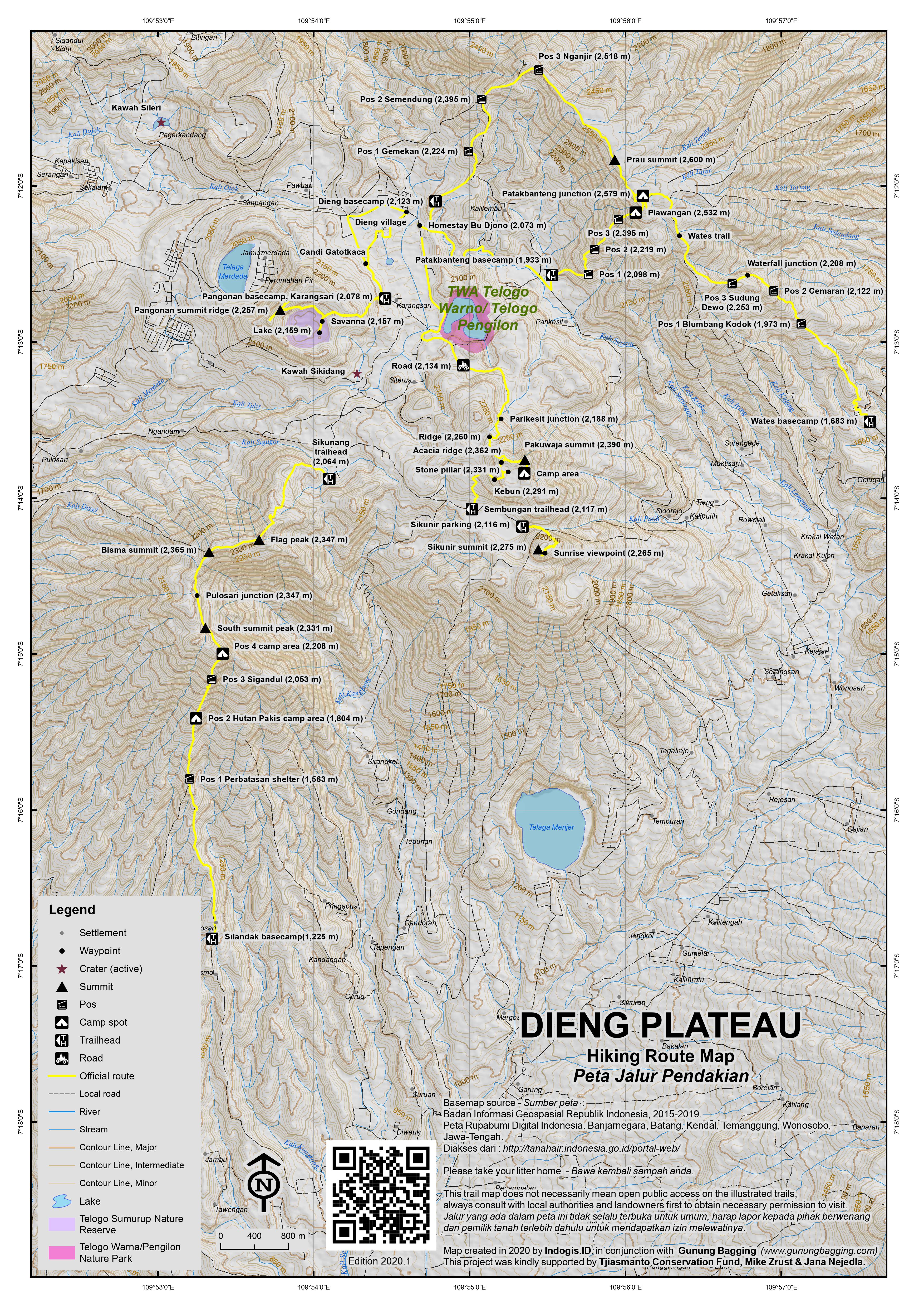
For a high quality PDF version of this and other trail maps, please download from our Trail Maps page.
Practicalities
- Getting there: For domestic flights from or to Central Java, such as the airports in Semarang, Solo (Surakarta) and Yogyakarta/Jogjakarta we recommend Baolau. Most people come to Dieng via Wonosobo from the south from either Yogyakarta or Purwokerto (from where there are frequent buses) and these are the easiest options. Those travelling from Jakarta are advised to get a train to Purwokerto then a bus up to Wonosobo (3 hours, Rp35,000). Then, take one of the many small buses plying the Wonosobo-Dieng-Batur route (1 hour, Rp20,000). The closest train station to Dieng is actually Weleri, Kendal, between Pekalongan and Semarang on the north coast. Unfortunately, only a handful of economy class trains stop here at present but it is hoped it will become a more important stop on the north coast main line in future. Note that in 2020, a military airbase called Sudirman Airport in Purbalingga is currently being renovated and will hopefully be open to the general public from 2021. This could make a weekend trip to Dieng from Jakarta much more efficient, time-wise. For now, Semarang and Yogyakarta airports are the closest. If you are feeling particularly adventurous the area can also be reached from the north if you take a bus from Pekalongan to Bawang (2 hours) and then an ojek (motocycle taxi) up into the hills as far south as you can (30 minutes). This northern route from Bawang to Dieng used to be passable but the bridge over the river was swept away many years ago. With due care, descend then cross the river on foot and rejoin the steep farm track at the other side of the river. The track ascends through farm plantation and soon you will be on a proper tarmac road again. There are plenty of villagers and farm workers in this area so you may be able to arrange another ojek to Dieng. If not, in total it is only 2 hours from the river to Dieng village itself and could well save you time if trying to reach the Plateau from the north. One other route in is from Banjarnegara to the southwest but given how windy the roads are and how unreliable the public transport is, this is perhaps for those with extra time or their own vehicle.
- Guides and GPS Tracks: Want a PDF version for your phone? Looking for a guide? Need GPS tracks and waypoints? Gunung Dieng information pack can be downloaded here.
- Trip planning assistance: Would you like Gunung Bagging to personally help you in arranging your whole trip? Please contact us here.
- Permits: Rp10,000 per hiker (in 2019) for Gunung Prau. Similar for Gunung Sikunir. Register at the relevant basecamp. All hiking trails usually closed January-March. Other hikes in the Dieng area tend to be obscure obscure enough not to have tickets or registration booths. As for craters, lakes and others sites, there are a variety of fees (mostly very reasonable). For Candi Arjuna (Arjuna temple complex) and Kawah Sikidang, one ticket including entry to both places costs Rp30,000 for foreigners or Rp15,000 for locals and KITAS/KITAP holders. Motorbike parking is typically Rp3,000 per site.
- Water sources: Take enough bottled water with you for any significant hike such as Gunung Prau – in most cases one large 1.5l Aqua per person should suffice unless you are camping and cooking up there.
- Accommodation: Try the Booking.com map above or use this link to search for suitable hotels, homestays, resorts and apartments for your trip.
- We recommend Safety Wing as travel insurance for overseas travellers and tourists hiking up to elevations not exceeding 4500 metres.
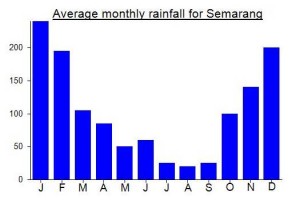
Local Average Monthly Rainfall (mm):
Location
Click on the blue arrow ![]() (top right) to see your current location on the map
(top right) to see your current location on the map
Origins and Meaning
Dataran Dieng = The Plateau of the Great Gods. Dieng seems to be a modern contraction of the words da – hyang. In Old Javanese da (sometimes ra) is a kind of title in front of the name or title of someone of high rank, and hyang means “a god, goddess, deity”. So dahyang means “the great gods”. Compare this with the place name Parahyangan which is still in use today to denote the mountainous interior of West Java. Parahyangan consists of ra-hyang (the great gods) flanked by the prefix-suffix combination pa-an which signifies a place. So Parahyangan means “the place of the great gods”. (George Quinn, 2011)
Prau means ‘boat’ and refers to the shape of the actual mountain which looks like an upside-down boat (see also Tangkuban Parahu in West Java).
Links and References
Wikipedia English
Wikipedia Indonesia
You could visit the Dieng Plateau several times without knowing of the existence of the Pangonan savanna, a lovely grassy area presumably once an old crater. The only way you would know is if someone told you or you looked on the satellite version of Google Maps or similar. Anyway, it is well worth a half-day out, being easily walkable from most of the homestays in Dieng village.
Alas, the great majority of the homestays here are Shariah / Syariah, which to the owners means that they uphold the current populist form of moral integrity, presumably because these days Indonesian tourists far outnumber Westerners, similar to Malaysia’s Cameron Highlands. Dieng is an ancient site of great significance, with Hindu temples from the 7th/8th century, so sadly the irony of shariah hotels in such a place, entirely determined by a particular sectarian ideology from Saudi Arabia really is completely lost on most of the folk here. Never heard of a Hindu Hotel or a Catholic Hotel, in Indonesia or elsewhere.
The Arjuna temple complex opens at around 0730, the same time as the Pangonan basecamp, so depending on your itinerary you can pay Rp20,000 to take a shortcut from where most of the hotels are in Dieng village over to Pangonan, or alternatively walk round the longer way. I walked round the longer way because I set off before 0730 but cut back across to my hotel via the temple complex.
The basecamp was still shut at 0730 so I sent a message to a contact and was told just to start hiking! Upon my return just under 2 hours later it was still padlocked shut! The important thing is to turn right at the back of the basecamp and then it is obvious to take a left up some wooden steps and into the forest.
There are shelters every few minutes and you can be at the savanna in about 30-40 minutes. For those keen on getting a view of Telaga Merdada, take the summit trail from the junction just before the savanna. I saw some large droppings on the summit trail – some kind of ‘big cat’ I think. Within 15 minutes I was on the summit ridge where a bunch of local students were camping. Low cloud so no view of the lake on the other side but this would be the place.
Folk do not seem that interested in bagging the true summit which is to the right. I followed the trail for 10 minutes, crawling under vegetation before thinking better of continuing when there would be no view anyway. Taking a left from the camp is much easier, to the south-western top which has some kind of sensor on it. Again no view when I was there but might be very pleasant in better conditions.
I visited the savanna on the way back – a lovely spot growing in popularity since the trail was opened by Governor Ganjar in Feb 2016. You only really need 2 hours to do the return hike, or 3 if you fancy having a go at the true summit!
Note on getting to Dieng. We decided to try to approach Dieng from the Semarang side this time, but overall I would say getting the fast little buses from Purwokerto is a much, much better option unless you have your own private vehicle. All 3 of the ‘travels’ that we used were unprofessional and unreliable. Every single one of them! They got progressively worse. I was mad at the time but it is quite funny now, the murky depths to which these companies can sink to in terms of unprofessionalism.
First up was Kencana Travel from Kudus to Semarang. After booking online they called to say it was already full, as if
it was somehow our fault for booking rather than theirs for taking our money and not updating the website. They stuck us on an earlier shuttle, which meant getting up earlier than we wanted and having a long wait in Semarang for shuttle number 2 to Wonosobo.
Up next was Aragon Transport. Arogan Transport would be a better description. They asked us to be at the starting point earlier than the arranged time. Fine. We set off early – unusual in a positive way. This soon turned out to be less positive, with the driver going all over the city picking customers up, way off the main route. At 2pm, over an hour after departing we were still in Semarang. Quicker and cheaper to get the normal buses. Indeed, the claim that we would be in Wonosobo by 1530 was complete garbage. We didn’t arrive until nearly 1800.
And then the next day, we had booked with Mitra Trans to take us from Wonosobo at 1300, to arrive at 1530 in Semarang (again, nonsense as the minimum travel time is realistically around 3 and a half hours). But, as usual, they couldn’t just do what they had promised but had to phone up at 9am to ask if we wanted to take the 11am shuttle instead of the 1pm one. As I was still hiking I said we had better stick to the 1300 one, as we still had to get the bus back down to Wonosobo from Dieng. We waited in a café in Wonosobo when we got the message that the shuttle would arrive at around 2pm (one hour late). We asked where it was. Purbalingga apparently. Probably picking up a customer from some ludicrous distance away from the actual route of the journey. As we had to get rapid antigen tests done in Semarang for the train home we were worried this was going to end in trouble. So Mitra Trans man found us an alternative ‘travel’ that would pick us up at the arranged time of 1pm.
Unfortunately when it arrived, it was not a proper minibus but rather a dirty old car with other passengers and no social distancing possible. For 135,000 a seat this was a scam. But we needed to get to Semarang so we stuck with it. Unfortunately, the driver pulled in to Wonosobo bus terminal. Presumably for lunch or a smoke or something. Very frustrating. After 30 minutes we were still waiting for this utter pillock to get back to the vehicle and I was livid, so we got out and walked away, ordering an expensive Grabcar to take us all the way to Semarang. At this point, the driver suddenly got up and came running over to say we would be leaving now, but it was already 1345 – and who could guess what nonsense would happen next?
Folk want to get from A to B, but many Indonesian travel operators seem to try to do anything but get you from A to B, even though it is the main aim of the service. They are about as unprofessional as it is possible to be, doing things on their terms, not according to the wishes of their customers or the agreed timetable. Mitra Trans have not yet agreed to give a refund of our 270,000 and probably won’t because they think this level of service is normal, presumably because most of their passengers do not complain and seemingly acccept a 3.5hr journey taking nearly all day even when there is a published timetable which people book with in mind.
So… avoid the travels from Semarang to Purwokerto via Wonosobo – utter garbage! Are they incompetent or do they deliberately treat their customers with disdain? Probably a mixture of both.
The Java Lava hiking group in Jakarta have just released their intended schedule of trips for 2021, covid-dependent. Hilariously, a Gunung Bismarck is listed again, as it was for 2020 (a schedule that was postponed) as part of a Dieng trip.
According to all reliable maps of the region, no mountain with the name Gunung Bismarck (!) exists in the Dieng area, and they presumably mean Gunung Bisma / Bismo! If anyone does discover a Gunung Bismarck on the Dieng Plateau, please get in touch!
Just made another weekend trip to Dieng – planned the usual route…train to Purwokerto then bus to Wonosobo then smaller bus up to Dieng. Things didn’t run as smoothly as on previous trips due to a few issues – some specific to the management of sites at Dieng, and some specific to transport. These things are ok once in a while, but when you have a whole series of hassles your trip ends up being rather unpleasant. I can understand why private cars are increasingly popular – precisely because you avoid much of this nonsense.
The first was before we even got to Gambir to catch the train. Ordering a large Gocar for 4 passengers costs more this year due to the social distancing thing so you need a 7-seater – anyway, naturally after ordering this, the car turns up and it is not the car registered on the app and it is just normal size rather than a 7-seater. So the choice is complain and re-order and be delayed, or just accept it and get on with it, with no social distancing and the driver getting a cash bonus without providing what was promised. This is all too common and why Indonesia will likely remain a developing country – so little integrity and honesty to be found on a daily basis. But plenty of short-cuts, scams and hassles.
The train ride was pleasant as usual, and on time as usual, but no coffee available for the entire journey. Imagine that, a coffee producing country but you can’t even get a black coffee in the dining car on the train. Given that KAI sorely need the profit this year, you wonder why they let things slip so far that their stock is so limited and they miss out on food and drinks sales. No logic from the point of view of a customer. Perhaps it’s best to bring your own flask at present! Bizarre.
The next was at Purwokerto train station, where there is the usual scrum of locals waiting for passengers to try to offer them transport. Quite a few wearing a uniform of sorts, but our ‘taxi’ driver didn’t have a meter and was driving just a regular car. So, you have to discuss the price. Rp50,000 to the bus terminal is acceptable but I have no idea if that was being over-charged as there is no level of professionalism beyond the shirt that makes them look official even if they are anything but. It’s just a guy with a car wearing the same top as several of his mates.
Why is it not regulated better? But I could say the same for places like Kampung Rambutan bus station in Jakarta and the anti-Grab mafia at many airports though – people think they can follow you around and bully you into paying them some money for a below-par service. The authorities need to regulate these places and make them more orderly. It is not complicated, but any rules are just ignored it would seem. But it makes for an unenjoyable experience especially for foreigners who get more attention than wanted anyway.
The next was Purwokerto bus terminal, where there are a lot of folk sitting around doing very little except waiting for a new potential customer to arrive. Sadly, their behaviour would be regarded as harassment in most countries and if you are in a group you will be followed by these people, each trying to ask a different member of the group, all trying to make some cash out of you but acting like they just want to help. We were ushered into a ticket booth for tickets on to Wonosobo and I asked how much and he had to think first, as if it was the first time he had ever sold a ticket! Or rather, he was wondering how much he could get away with asking for after weighing me up. Presumably he was thinking ‘foreigner so can charge more, but speaks Indonesian so not too much more’. Finally out came Rp50,000, a lot more than the Rp30,000 of last year and making a real difference when you are paying for 4 tickets so I just walked out and dodged the guys who continued to follow.
It’s a shame because the bus terminal itself is quite nice by Java standards. Bulupitu is the name. But whoever is managing it needs to look at doing something to stop these guys from following customers around. It is as if the experience of the bus passengers is not as important as a rude mob following you around and trying to make some profit out of you. Their right to hassle you is more important than your right to be left alone. I understand it has been a hard year but it is really bad manners to harass customers like this. Just set up a fair system that benefits all and makes the travel experience pleasant. Perhaps this is simply too hard a task.
When the bus driver of the next Wonosobo bus was found he didn’t respond verbally to my question about ticket price, but merely put up 4 fingers and continued smoking his cigarette, perhaps wondering if I would be so stupid as to pay Rp400,000. Too cool to just say ‘Rp40,000, mister’ as is the standard expected from someone in such a circumstance. It was the usual small type of bus for this route going very, very fast, almost exhilaratingly so. But it turned out we paid an extra Rp5,000 per person more than we should have done. Again, the local government needs to regulate these services better.
We arrived in Wonosobo at around 4pm, getting off at the road junction at the A Yani statue. Again, lots of folk milling around smoking and trying to make some money, chatting with us but more than we wanted, to the point of extreme nosiness and thinking up ways they could make a quick buck by ojekking us somewhere. Sometimes you just want to be left alone – imagine if any of these guys were being followed around when not standing on home turf – they’d absolutely hate it. We were just waiting for the bus, but it was like being on stage in a wayang orang, but a wayang orang you really aren’t interested in being part of.
No Dieng/Batur buses came for a period of over 30 minutes so we ended up with Grab which turned out to be a local taxi. At Rp225,000 for the last leg of the journey it dented our budget a bit as the bus would have been Rp20,000 each, but it seems there are hardly any doing the route after mid-afternoon which is pretty annoying. Indeed, the Rp500,000 that the ‘taxi’ driver at Purwokerto train station quoted to take us all the way to Dieng might have been a better idea for a group of 4 as it would have avoided all the transit points and hassle and only been Rp100,000 extra. Sometimes you are exhausted before you even reach your destination. So it was a welcome relief to eat kentang goreng and drink a beer at the genuinely friendly Bu Djono’s. This is where we hired motorbikes.
We did Sikunir the following morning, and it was completely packed – almost impossible to social distance. The weather was below average so not much of a sunrise but a pleasant stroll nonetheless. But the number of tickets you need to buy is over-the-top. Two each for entry (one is Rp5,000 and another Rp10,000) about 1km before the trailhead plus a parking ticket at the start of the path. It’s a waste of paper and feels like every damn kilometre you are being asked to pull over and open your wallet. It gets tedious. A Rp50,000 ticket for all places on the Plateau would be much preferable.
We called at Sikidang on the way back, but the entrance was different to the standard one I remembered from previous trips. Not sure what is going here. The signs guide you down near the geothermal plant along a rocky track. There’s a ticket booth, but it’s just a little wooden booth with two guys asking for money. No tickets given but paid Rp10,000 per person. You can’t always trust the signs, even if they look fairly official!
Towards the crater itself there is building work going on (it feels like this is the case almost everywhere in Indonesia – construction work, chainsaws, circular saws, workmen, noise, people revving motorbikes without good reasons, people staring at you). There’s a new wooden walkway from the proper entrance but it is not finished and as usual there is no alternate route to the crater set up – just people improvising by clambering over dirt and mud. A real mess. Pleasant scenery if you could avoid all the construction work in your vision.
Back at the parking spot and we had to pay again for parking the motorbikes. No tickets so probably unofficial. Over at Candi Arjuna we were told our temple tickets would get us free entry to Sikidang too. Kind of annoying that we had just been there and been given no tickets at some dodgy half-official entrance. As seems to be the theme of this weekend, what are the authorities doing, allowing 2 different Sikidang entrances with official-looking signs? The visitor just feels scammed. Have the authorities tried and just given up when so many locals ignore rules, or not even bothered to try in the first place? So, we had to pay again, for a ticket that would get us free entry to Sikidang via the normal route. And the Candi Arjuna exit route is quote unnecessary – just sending you on a long loop past another guy with his hand out for money and ten stalls selling exactly the same items for (one assumes) identical prices. What a mess. It feels very disorganized in 2020.
Sad that all this harassment colored the weekend somewhat – both the excessive ticketing, construction work and semi-fake or unofficial entrances round Dieng and the transport hassles. But the Plateau of course remains a great spot, especially if you can avoid the weekend crowds. Shaun The Shep (sic!) and the teletubby men were at the temples as usual, adding to the surrealism, but when you look behind the costumes or context you see your interaction with them is, like so many, just another way of them saying ‘give me money, mister’.
After Gunung Kembang (Child of Sindoro) I headed to Dieng for some kentang goreng and much needed rest after a night with no sleep. The next morning, Taufik picked me up at Bu Djono’s at 4am for our planned traverse of the fantastic Gunung Bisma. I would say this is almost as good as Gunung Prau – brilliant views at sunrise and a great, long ridgewalk. You could of course head back to Dieng rather than heading all the way down to SIlandak, but the traverse is the best way of getting to understand more of the character of the mountain.
At present Gunung Bisma / Bismo is very much a mountain of two sides, with very few hiking from the Dieng side and no signs, and then perhaps 100 or more hiking on weekends from the southern side at Silandak. Lots of campers up there. We had great weather, started around 4.20am and were down in Silandak by 8.30am or so, with 30 minutes or so spent admiring the views from the long summit ridge. I then got an ojek to Wonosobo (Rp40,000) and took one of those little hurtling buses back to Purwokerto for the train home. Lovely views from the Bumiayu area towards Gunung Slamet, which at present is off limits due to increased volcanic activity.
If you’ve done Prau and find yourself back in the Dieng area, this comes highly recommended. I predict there will be a basecamp on the Dieng side in the next year or two as it is such a great viewpoint and pretty easy!
Went up yesterday morning, by the standard route from Dieng village. Left in the dark around 04.40. Basecamp was still sleeping so no entry fee to pay. Got up to the ridge around 05.20, by which time it was light. Sunrise proper was around 05.30. The first part of the trail is a sort of farm track which has been turned into a wet gully by scooters. The ascent, thru the wood, is badly eroded, a mass of completely exposed tree roots. Really, they need to install some stones as steps here. Met a school group on the way up. The ridge walk itself however is better defined and really pleasant. Lots of birds. I only went about 1km along it to get to the first open view of Sindoro and Sumbing, before turning back. There were a few locals up there but it was fairly quiet. And almost no litter at all, such a pleasant surprise! Amazing views all round. Sunrise itself is perhaps overrated, and no sign of clouds on the horizon a couple of hours later. So going up a bit later would have been fine.
Spent a very pleasant weekend up on the Dieng Plateau. Got one of the trains from Pasar Senen to Purwokerto on Friday after work, staying at Wisata Niaga which was in surprisingly celebratory mood despite being Ramadan. The next morning took a Grab to the bus terminal and got in one of the many small buses that hurtle from Purwokerto to Wonosobo via Purbalingga and Banjarnegara.
There is a new airport (or rather an old military airport renovated and opened to the public) supposedly in operation from 2020 which depending on flight times might make the journey to Dieng an easier one. But, aside from climate change, the train journey is pleasant enough and the buses go fast enough for you never to feel that you are not making good progress. Bus costs Rp30,000 which is very reasonable for the distance. Under 3 hours.
In Wonosobo, make sure you get off at the fork in the road (the driver should call out for Dieng) or else you will end up at the bus terminal which is several kilometres in the wrong direction. Once again, there are tons of buses heading from Wonosobo to Batur via Dieng village (one had arrived within 5 minutes of waiting) and at the time of writing the cost is Rp20,000 (under one hour). So basically only Rp50,000 per person all the way from Purwokerto to Dieng.
We had booked as usual at Bu Djono as they have knowledgeable guys working there, adequate rooms in a central location, good kentang goreng and beer available (unlike all the syariah hotels that have sprung up over the last few years to cater to domestic tourists).
Dwi is still working there, as is Taufik, who I later found out was my guide back in May 2010 when i first visited the area. This was before social media catapulted Gunung Prau from a place nobody bothered with to a sunrise selfie spot that is frankly too popular now. Taufik recalled I stayed at Gunung Mas Hotel that first time and he remembered it well because I was the first tourist he took up the mountain!
We borrowed a bike and sped round the usual sites. Light rain but even in bad weather Dieng is a special and atmospheric place. I noted once again the nasturtiums growing up the walls of abandoned buildings and on the verges near Telaga Warna. These plants are well-known in the UK for their edible, peppery flowers, but not many know you can eat the leaves too. Lovely on a cheese sandwich. Maybe there’s an opportunity to build a business of some kind selling nasturtium-based products or snacks. I would definitely buy it.
Dieng was a little quieter that usual with it being Ramadan, but Bu Djono was busy at lunchtime with day-trippers from Yogyakarta, including a group of Chinese one of whom was startled when upon asking for the wifi password was told to order first. She said she had already ordered, and the reply came that yes, they knew, and the password for wifi was order first! I bought some Wonosobo coffee from the counter and am looking forward to tasting it later this week at work.
Sikidang crater was quiet, with stalls shut for Ramadan, and none of the fern vases for sale (vas pakis motif batik) which are utterly beautiful and look like incredibly detailed art yet are simply intricate patterns on highland fern trunks from Ibu Alam herself. As we were walking round the temple complex, air raid-esque sirens rang out piercing the air at half past five to let people know they could finally break their fast and eat once again without incurring the wrath of god.
Amazingly bumped into Oystein from Jakarta, who was here to do some aerial photography. The same week he made some great images including a particularly brilliant one of the entirely cultivated Pagerkandang crater.
The original plan was to get pre-dawn ojeks round to Sembungan and hike over Pakuwaja and all the way back to Dieng village but for a couple of reasons we ended up doing it in reverse. It didn’t make much difference as there was sadly rather a lot of low cloud around. Still a worthwhile hike though whatever the weather, and presumably an incredible viewpoint in clear conditions. Recommended to anyone who doesn’t want to be surrounded by hundreds of other hikers up on Prau and Sikunir.
I have to come back later in the year anyway, for a traverse of Gunung Bisma. Plan would be to hike up to the top for dawn from the Dieng side and then continue all the way down to the other trailhead down vaguely in the direction of Wonosobo. I may combine this with a hike up Gunung Kembang on the SW slopes of Gunung Sindoro – another great viewpoint.
Mas Taufik was a great hiking companion after 9 years since the last time, and I wholeheartedly recommend him (and also Dwi as recommended below in a previous comment) as an enthusiastic and knowledgeable guide for any of the Dieng hikes. Here is Taufik’s WhatsApp number…… 081229075300
One of the few significant peaks in Java I hadn’t explored until this week was Gunung Rogojembangan. Given how short the hike is, I decided to do a mad bag by getting a trail to Pekalongan arriving at midnight, going with Bang Ahmad on his motorbike to the base, hiking up for dawn and then back down and out to Pekalongan and back on a train at 12 lunchtime back to Jakarta (5 hour train journey). Alas the weather was cloudy and we had slight rain – the best views were at Gambir at dusk as I boarded the train – very atmospheric views over Monas. The trail itself was tougher than expected, mainly because the middle section was overgrown and with very low bamboo making it difficult for anyone over 1 metre tall. You really have to expect a bit of crawling here! It was well worth it despite the lack of views. The journey itself from Pekalongan is very scenic, as you head up into the hills from sea level to over 1,500m. Many thanks to Bang Ahmad and his friends for so kindly taking me to this place.
A very good mountain with a view, Sunrise and the peak is so beautiful.
Definitely one of the best viewpoints in Java. Glad to have made it back to Prau for a second time, especially as the weather was much better this time around. As with many of the ‘previously quiet’ hikes in Java such as Parang, Butak and so on, this is now an incredibly busy spot at weekends with local hikers, but the crowds are mostly just at the Patakbanteng junction area of the ridge so you can still find beautiful solitude by walking in the opposite direction for five minutes.
We did a circuit of both central Java and Gunung Prau itself. Friday night train from Jakarta to Purwokerto, then a bus the next morning from perhaps Java’s cleanest bus terminal on the edge of Purwokerto up to Wonosobo (Rp30,000, under 3 hours). There seem to be small buses or minivans continuing up to Dieng from time to time but we wanted to get up there rather than wait around so we got a metered taxi direct to Bu Djono’s for Rp170,000. It took about 45 minutes including 5 minutes of delay at a recent landslide area where the road is being carefully reconstructed, or ‘rehabilitated’ according to the bizarre signs.
The main Dieng tourist attractions are much as the same as before, with people dressed up as Shaun the Sheep and various Teletubbies characters for you to get a photo taken with them. Also now various owls chained up at Kawah Sikidang so Harry Potter fans can get owl photos – though the owls themselves can’t enjoy this much, being nocturnal beasts. Little chunks of giant fern trunks also for sale – very beautiful, as though the intricate pattern had been designed. If you made the terrible error of being born in a foreign country and don’t have a KITAS or KITAP, you now have to pay Rp100,000 (Monday-Friday) or Rp150,000 (weekends) to visit Telaga Warna, though the experience at weekends is almost certainly not 50% better than at other times. Watch out for the beautiful but deadly angel’s trumpets flowers (Brugmansia) which grow in abundance at Telaga Warna and Arjuna temples – if ingested these things can take you on a mind-bending trip of a very negative and potentially fatal nature.
The hike itself was wonderful – especially the litter-free descent to Wates, but perhaps in another 7 years the Wates route will be crowded too. It would be great if a route heading directly north was more obvious and popular, as getting up to the north coast is still a bit time-consuming considering the distances involved. Indeed, the bus journey to Pekalongan was harder on the legs than the hike itself! Most notable incident was when the guy sitting next to me got up to disembark at Onion village and dragged a huge turkey from under our seat that had been resting, tied up, just centimetres from my ankles. I had no idea.
Finally, there are some interesting fines listed on official basecamp leaflets. Some are very worthwhile, such as for the use of trailbikes on the mountain, the leaving behind of rubbish, and the chopping down of trees. Others are slightly more moralistic and eccentric, such as a fine of ‘3 bibit’ for urinating into a bottle, ‘4 bibit’ for ‘carrying alcoholic drinks’, and ’10 bibit’ plus being reported to the authorities for committing adultery up on Teletubbies hill. Still trying to get my head around the ‘bibit’ system of fines, but my best guess is that this is a way of reforesting the higher slopes by planting new trees as ‘bibit’ means ‘seed’.
Nice and very helpful article! My friends are planning to also hike Mt. Prau this coming month. We will come straight from Jogja and go to Semarang after. Any idea on how to get to Semarang from Dieng?
Just back from a second trip to Dieng. One of the most fascinating and friendly spots in Indonesia. To save time, we caught the train to Purwokerto on Friday evening and then took a bus to Wonsobo the following morning. There are buses running about every 10 or 15 minutes and most of the shoot along at terrifying speed. Cost was Rp25,000 per person and took 3 hours or just under.
Once in Wonosobo we had trouble finding transport on to Dieng as there may be more than one bus station (‘terminal’) so we ended up getting a taxi up there for Rp125,000. Nusa Indah 2 is a very central place to stay, new and clean but the sound from the mosque is incredibly deafening at 4am so if you have to get up early it’s ideal but if you want a lie in then it’s a terrible place to stay!
Met a very friendly chap called Dwi at Bu Djono homestay and restaurant (the best place to eat in Dieng) who has a website http://www.dwidieng.com and speaks excellent English and is highly recommended. One of the best guides in Indonesia. His number is 085310791967.
The afternoon we took ojeks round to the main sites (Rp50,000 for the circuit of the main natural attractions). Bizarrely, there were men dressed as teletubbies at the Arjuna temple complex. Kawah Sileri remains relatively unpopular as it is 3 km or so out of town and that’s great – it’s a brilliant spot to sit in the late afternoon/dusk and watch the smoke swirl above the lake.
The short hike up Gunung Sikunir was planned for the following morning but early morning rains and too much beer the night before meant this was delayed until 9am. You really need transport to get out to the starting point, Sembungan, which lies on the edge of a lake, Telaga Cebong, and at 2300m is said to be the highest village in Java. It takes about 20 minutes by ojek from Dieng village. There are warungs and a carpark and at weekends the place will be full of mainly domestic tourists.
From there it’s just 20 minutes to the top of Sikunir (2,394m) on a very popular and well marked path. You don’t need a guide, but at present it’s Rp120,000 per person to do the sunrise hike including transport from Bu Djono homestay. Not bad at all. Sikunir is not the highest peak in this little area – even it’s less-often climbed neighbour Pakuwojo is a little higher at 2411m. However the ‘golden sunrise’ is supposed to be particularly fine. 15 minutes or so after the golden sunrise on Sikunir, there is apparently a ‘silver sunrise’ at the Arjuna temple complex.
We tried the local herb, Purwaceng, which is for sale everywhere round Dieng, and mixed with coffee and so on, and is apparently good for ‘male stamina’ amongst other things.
From the top of Sikunir the views were on this occasion limited by the clouds but the view over the lake below and to the Wonosobo road and viewpoint are excellent anyway.
After that it was back to Bu Djono for more delicious local kentang goreng (friend potatoes). We then decided to try the other route back to Purwokerto (down to Banjarnegara). We got ojeks for 140,000 per person (including calling off at the fascinating kawah Candradimuka on the way) and it was pretty good value consider the distance and scenery (it’s about 58km away). You could theoretically get minivans all the way down but this would involve a lot of waiting around for the vans to fill up. From Banjarnegara you are back on the main road between Purwokerto and Wonosobo so it’s easy to get a bus back west.
Dwi told us that there are some pitcher plants growing up on Gunung Prau. I never noticed this last time, so I may make another visit to the area sometime before too long.
prau mt, nice place in the world 🙂
hi,
is it possible if i use motobike from jogja to dieng? i was plan just to visit the lake and villagers.
yes its possible. it takes about 4 hours on bike
Residents in the Dieng area are being evacuated after the volcano spews poisonous gas…. http://www.thejakartaglobe.com/home/alert-raised-over-volcanos-deadly-gas/444182
Most visitors to Dieng Plateau would visit Gunung Sikunir for the sunrise. However when doing research using Google Earth, I found Gunung Prahu to be the tallest mountain in the region, offering a better view as well. Since this mountain is rarely visited, photos and reports are almost unavailable elsewhere on the net except on Gunung Bagging.
I arranged for a guide at Bu Djono’s Homestay on the second day at Dieng Plateau and started the hike at round 2pm, planning to stay overnight on the mountain. The starting point is just to the east of Dieng village. The hike was a 1.5 hours of ascend trough jungles followed by another 1 hour’s ridge walk (The summit rigion of the mountain is a long ridge). The ascending part was pretty slippery for my case since it rained like mad the previous day, and I can’t really comment on the view since I was shrouded in mist all the time. The ridge walk, though, was an easy and pleasant one through flower beds full of daisies.
The placed I camped is probably Gunung Patakbanteng as mentioned in Daniel’s trip report on Gunung Bagging. The place is marked with a short cement pillar and is the southern end of the summit ridge, further down southwest is PatakBanteng village. There are plenty of space to camp near the pillar, however the west is obstructed by a taller hill. The top of the hill is covered with tall trees with little space to camp. To get a bird’s eye view of the west, one has to climb up this hill. In terms of weather, it wasn’t as windy as those 3000m peaks in Java, but the relatively higher humidity made up for it.
The sunset was completely clouded out for my case, and my camp site was constantly shrouded in mist till midnight. It all cleared up after around 2am, and the sky was full of stars. Gunung Sindoro and Sumbing could be seen faintly lit up by starlight. The camp site offered a completely unobstructed view towards the east and south, and the morning view of Central Java peaks is unbelievable. Gunung Lawu, Merapi, Merbabu, Ungaran, as well as nearby Gunung Sumbing and Sindoro make for a surreal and incredibly photogenic sight. Rolling sea of clouds for my case further added to the view. To get a view of the west, I hiked up the small hill to the west mentioned earlier. The view as a pleasant surprise to me as smoking Gunung Slamet and distant Gunung Ciremai came into view, since I didn’t expect to view to be so extensive. The whole Dieng Plateau, numerous villages, craters, and even Arjuna Temple Complex could be seen. Major tourist attractions such as Kawah Sikidang (mud volcano) and Telega Warna (multi-hued lake) are impressive viewed from up above.
I chose to descend southwest to Patakbanteng village. The trail was similar to the ascending trail, taking less than 2 hours, again pretty slippery for my case. The view west and south was fantastic in open areas. Gunung Sumbing gradually went hidden behind Gunung Sindoro as I descended. There are freuquent buses to Dieng village stopping at Patakbanteng.
I could say that Gunung Prahu offers one of the best summit views in Java, and it will not dissappoint any hiker on a clear day. The hike is also less demanding with a mild camping condition, campared to those 3000m peaks in Java. I’m really surprised why this one is so rarely hiked. Rating? 10 out of 10.
i like ur poto in prau :thumbup
Thanks very much for the great report Jia.
When I went, I climbed onto the north-west to south-east ridge that is Gunung Prau/Prahu via the mast above Dieng village at the north-west end. I didn’t descend to Patakbanteng so never got as far as the pillar you camped at at the south-eastern end of the ridge. Using my GPS I found the true summit to be an unmarked spot on the ridge between the pillar you camped at and the telehone mast at the north-western end of the ridge above Dieng village.
Many thanks for sending your great photos in too, we will be transferring all galleries over to Google’s Picasa in due course.
Cheers.